ATL: PALOMA - Tropical Depression - Discussion

Moderator: S2k Moderators

Message
Author
User avatar
Tampa Bay Hurricane
Category 5
Category 5
Posts: 5597
Age: 37
Joined: Fri Jul 22, 2005 7:54 pm
Location: St. Petersburg, FL

Re:

#361 Postby Tampa Bay Hurricane » Fri Nov 07, 2008 2:26 pm

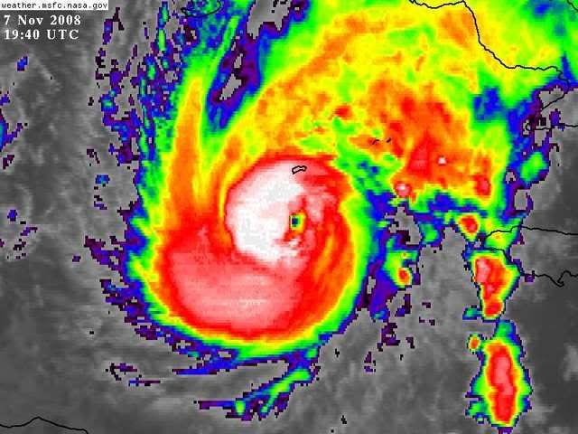
CrazyC83 wrote:Just got an eyewall drop: 84 kt at the surface.


Hmm...they could/might go with 100 mph then....
0 likes   

jinftl
Category 5
Category 5
Posts: 4312
Joined: Tue Aug 31, 2004 4:47 pm
Location: fort lauderdale, fl

Re: ATL: PALOMA - Hurricane - Discussion

#362 Postby jinftl » Fri Nov 07, 2008 2:30 pm

Winds at 38 mph, gusting t0 53 mph as of about 25 min ago at Owen Roberts Airport on Grand Cayman....just shy of sustained ts winds.

http://www.wunderground.com/global/stations/78384.html

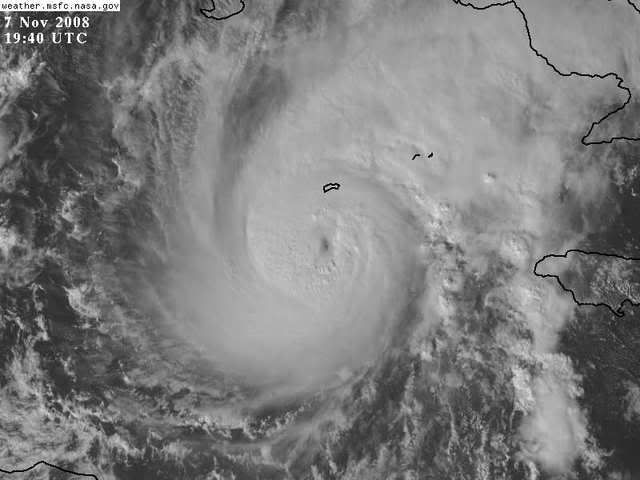
wxman57 wrote:I'm measuring a 3-hr movement toward 17 degrees at 6kts. That course would take the eye just east of Grand Cayman Island in about 9 hours, or around 05Z tonight. Of course, assuming no wobbles or speed changes. Grand Cayman is 60 miles north of the center and the 18Z observation was easterly at 31 gusting 45 kts. Still no TS force winds, but close.
0 likes   

User avatar
gatorcane
S2K Supporter
S2K Supporter
Posts: 23689
Age: 47
Joined: Sun Mar 13, 2005 3:54 pm
Location: Boca Raton, FL

Re: ATL: PALOMA - Hurricane - Discussion

#363 Postby gatorcane » Fri Nov 07, 2008 2:33 pm

Observe the nearly perfectly symmetric "ring" of cirrus that extends well out around Paloma up to the SE GOM and the FL Straits.. and over to almost the Yucatan Peninsula....I see no evidence of shear north of 20N quite yet. Could another anticyclone being building over Paloma? Very intense systems can build anticyclones over them. At the same time this may be the best Paloma will ever look so get a good look before the shear arrives later tonight and into tomorrow.

Image
0 likes   

User avatar
HURAKAN
Professional-Met
Professional-Met
Posts: 46086
Age: 38
Joined: Thu May 20, 2004 4:34 pm
Location: Key West, FL
Contact:

#364 Postby HURAKAN » Fri Nov 07, 2008 2:49 pm

Image

Image
0 likes   

User avatar
HURAKAN
Professional-Met
Professional-Met
Posts: 46086
Age: 38
Joined: Thu May 20, 2004 4:34 pm
Location: Key West, FL
Contact:

#365 Postby HURAKAN » Fri Nov 07, 2008 3:03 pm

Best Track 18z:

AL, 17, 2008110718, , BEST, 0, 184N, 814W, 85, 974, HU

100 mph.
0 likes   

User avatar
wxman57
Moderator-Pro Met
Moderator-Pro Met
Posts: 22951
Age: 67
Joined: Sat Jun 21, 2003 8:06 pm
Location: Houston, TX (southwest)

Re: ATL: PALOMA - Hurricane - Discussion

#366 Postby wxman57 » Fri Nov 07, 2008 3:19 pm

Here's a McIDAS shot of the eye approaching Grand Cayman. I'm calculating a 3-hr movement toward 28 degrees at 7 kts now. That would put the center of the eye about 10 miles east of Grand Cayman Island around 04Z this evening.

Image
0 likes   

Derek Ortt

#367 Postby Derek Ortt » Fri Nov 07, 2008 3:21 pm

it might wobble back to the left. Looks like the smaller inner-eye is rotating around the larger feature
0 likes   

User avatar
mf_dolphin
Category 5
Category 5
Posts: 17758
Age: 68
Joined: Tue Oct 08, 2002 2:05 pm
Location: St Petersburg, FL
Contact:

#368 Postby mf_dolphin » Fri Nov 07, 2008 3:22 pm

That would put the western eyewall just about raking the island.... not fun.
0 likes   

User avatar
wxman57
Moderator-Pro Met
Moderator-Pro Met
Posts: 22951
Age: 67
Joined: Sat Jun 21, 2003 8:06 pm
Location: Houston, TX (southwest)

Re: ATL: PALOMA - Hurricane - Discussion

#369 Postby wxman57 » Fri Nov 07, 2008 3:33 pm

Last 3 hours of obs from Grand Cayman airport. Wind section is bold. Still no report of sustained TS wind and teh center is only 50 miles south of the airport. Small storm. Eyewall is approaching, though. Note the rotation of the wind from 080 to 070 to 060 degrees over the past 2 hours. That indicates the center is going to pass east of the airport. Strongest winds will be out of the north.

MWCR| |072000|75.0F|73.0F|94.2%|060|031|043|2147483647.00|999|OVC|Rain
MWCR| |071900|75.0F|73.0F|94.2%|070|033|046|2147483647.00|999|OVC|Rain
MWCR| |071800|77.0F|75.0F|94.2%|080|031|045|2147483647.00|999|OVC|Light Rain
0 likes   

Derek Ortt

#370 Postby Derek Ortt » Fri Nov 07, 2008 3:35 pm

Is the airport at georgetown?

if so, that is on the western end of the island. Likely would have stronger winds on the eastern end
0 likes   

User avatar
hurricanefloyd5
Category 5
Category 5
Posts: 1659
Age: 44
Joined: Sun May 02, 2004 10:53 am
Location: Spartanburg
Contact:

Re: ATL: PALOMA - Hurricane - Discussion

#371 Postby hurricanefloyd5 » Fri Nov 07, 2008 3:38 pm

The CayMan Island is going into the eyewall very very soon and the Hurricane looks to be RAPIDLY DEEPENING from what I can see on the Sat. Loop. Correct my if I am wrong anyone?????


http://www.ssd.noaa.gov/goes/flt/t1/loop-vis.html
0 likes   

User avatar
mf_dolphin
Category 5
Category 5
Posts: 17758
Age: 68
Joined: Tue Oct 08, 2002 2:05 pm
Location: St Petersburg, FL
Contact:

Re:

#372 Postby mf_dolphin » Fri Nov 07, 2008 3:43 pm

Derek Ortt wrote:Is the airport at georgetown?

if so, that is on the western end of the island. Likely would have stronger winds on the eastern end


Yes Derek, the airport is at Georgetown on the SW side of the island
0 likes   

Derek Ortt

#373 Postby Derek Ortt » Fri Nov 07, 2008 3:46 pm

would not be surprised if the winds were 10-15KT higher on the eastern end of the island just because those are onshore while those from Georgetown are coming from the land, where the co-efficient of friction is higher
0 likes   

CrazyC83
Professional-Met
Professional-Met
Posts: 34001
Joined: Tue Mar 07, 2006 11:57 pm
Location: Deep South, for the first time!

#374 Postby CrazyC83 » Fri Nov 07, 2008 3:50 pm

000
UZNT13 KWBC 072031
XXAA 57207 99188 70813 04581 99981 24402 02595 00671 ///// /////
92513 21802 05598 85244 17400 07097 70888 11400 10090 88999 77999
31313 09608 82016
61616 NOAA3 WXWXA PALOMA3 OB 30
62626 REL 1882N08130W 201608 SPG 1879N08144W 202150 WL150 03101 0
85 DLM WND 07588 980643 MBL WND 04103 EYEWALL 000=

Is that 95 kt surface winds?
0 likes   

User avatar
cycloneye
Admin
Admin
Posts: 143879
Age: 68
Joined: Thu Oct 10, 2002 10:54 am
Location: San Juan, Puerto Rico

Re: ATL: PALOMA - Hurricane - Discussion

#375 Postby cycloneye » Fri Nov 07, 2008 3:53 pm

AT 400 PM EST...2100Z...THE CENTER OF HURRICANE PALOMA WAS LOCATED
NEAR LATITUDE 18.7 NORTH...LONGITUDE 81.3 WEST OR ABOUT 40 MILES...
70 KM...SOUTH OF GRAND CAYMAN AND ABOUT 290 MILES...465 KM...
SOUTHWEST OF CAMAGUEY CUBA.

PALOMA IS MOVING TOWARD THE NORTH-NORTHEAST NEAR 6 MPH...9 KM/HR. A
TURN TOWARD THE NORTHEAST IS EXPECTED OVERNIGHT AND THAT GENERAL
MOTION IS EXPECTED FOR THE NEXT COUPLE OF DAYS. ON THE FORECAST
TRACK...THE CENTER OF PALOMA WILL PASS NEAR THE CAYMAN ISLANDS
TONIGHT OR EARLY SATURDAY AND BE APPROACHING THE COAST OF CENTRAL
CUBA LATE SATURDAY.

MAXIMUM SUSTAINED WINDS ARE NEAR 105 MPH...165 KM/HR...WITH HIGHER
GUSTS. PALOMA IS A CATEGORY TWO HURRICANE ON THE SAFFIR-SIMPSON
SCALE. FURTHER STRENGTHENING IS LIKELY AND PALOMA COULD BECOME A
CATEGORY THREE HURRICANE TONIGHT OR EARLY TOMORROW. SLOW WEAKENING
IS POSSIBLE BY LATE SATURDAY.
0 likes   

sevenleft
Category 1
Category 1
Posts: 315
Joined: Sat Aug 05, 2006 2:36 pm

Re:

#376 Postby sevenleft » Fri Nov 07, 2008 3:53 pm

CrazyC83 wrote:000
UZNT13 KWBC 072031
XXAA 57207 99188 70813 04581 99981 24402 02595 00671 ///// /////
92513 21802 05598 85244 17400 07097 70888 11400 10090 88999 77999
31313 09608 82016
61616 NOAA3 WXWXA PALOMA3 OB 30
62626 REL 1882N08130W 201608 SPG 1879N08144W 202150 WL150 03101 0
85 DLM WND 07588 980643 MBL WND 04103 EYEWALL 000=

Is that 95 kt surface winds?

Yes. It's not considered a sustained wind, but it's impressive nonetheless for that side (northwest) of the eyewall. Stronger winds should be found on the next pass through the east side.
0 likes   

CrazyC83
Professional-Met
Professional-Met
Posts: 34001
Joined: Tue Mar 07, 2006 11:57 pm
Location: Deep South, for the first time!

Re: Re:

#377 Postby CrazyC83 » Fri Nov 07, 2008 3:58 pm

sevenleft wrote:
CrazyC83 wrote:000
UZNT13 KWBC 072031
XXAA 57207 99188 70813 04581 99981 24402 02595 00671 ///// /////
92513 21802 05598 85244 17400 07097 70888 11400 10090 88999 77999
31313 09608 82016
61616 NOAA3 WXWXA PALOMA3 OB 30
62626 REL 1882N08130W 201608 SPG 1879N08144W 202150 WL150 03101 0
85 DLM WND 07588 980643 MBL WND 04103 EYEWALL 000=

Is that 95 kt surface winds?

Yes. It's not considered a sustained wind, but it's impressive nonetheless for that side (northwest) of the eyewall. Stronger winds should be found on the next pass through the east side.


I thought that was a sustained surface wind? Anyway, if they find 100 kt winds, I am sure a special advisory would be coming out.
0 likes   

User avatar
Evil Jeremy
S2K Supporter
S2K Supporter
Posts: 5463
Age: 31
Joined: Mon Apr 10, 2006 2:10 pm
Location: Los Angeles, CA

Re: ATL: PALOMA - Hurricane - Discussion

#378 Postby Evil Jeremy » Fri Nov 07, 2008 4:00 pm

Oh no! SE FL is boardering the 5 day cone! I am preparing to bunker up from the media storm that should be striking any moment now lol.

Anyways, It looks like Paloma is intensifying rapidly now, and I honestly would not be suprised to see a borderline Cat 3/4 within the next 24 hours. My prayers go to those down in Cayman Island and in Cuba right now.
0 likes   

User avatar
carolina_73
Tropical Storm
Tropical Storm
Posts: 148
Joined: Wed Jul 23, 2008 1:30 am

Re: ATL: PALOMA - Hurricane - Discussion

#379 Postby carolina_73 » Fri Nov 07, 2008 4:07 pm

The East end of Grand Cayman is getting sustained TS winds now. 1 minute average of 50mph and a peak gust of 61mph. The current pressure is 997mb. http://caymanchillin.com/caymanchillin-weather.html
0 likes   

jinftl
Category 5
Category 5
Posts: 4312
Joined: Tue Aug 31, 2004 4:47 pm
Location: fort lauderdale, fl

Re: ATL: PALOMA - Hurricane - Discussion

#380 Postby jinftl » Fri Nov 07, 2008 4:07 pm

The front that was forecast to sweep through florida this weekend...guess what, it isn’t going to ever get to south florida…

AREA FORECAST DISCUSSION
NATIONAL WEATHER SERVICE MIAMI FL
125 PM EST FRI NOV 7 2008

FOR THE SHORT TERM...TONIGHT THROUGH SUN...THE SURFACE RIDGE OVER
CENTRAL FLA MOVES EAST...PUSHED BY THE COLD FRONT ASSOCIATED WITH
THE UPPER TROUGH. THE FRONT MOVES INTO N FLA OVER NIGHT...SLOWS
...STALLS AND EVENTUALLY DISSIPATES OVER CENTRAL FLA SUN.
0 likes   


Return to “2008”

Who is online

Users browsing this forum: No registered users and 38 guests