ATL: PALOMA - Tropical Depression - Discussion

Moderator: S2k Moderators

Message
Author
Sanibel
Category 5
Category 5
Posts: 10375
Joined: Mon Aug 30, 2004 11:06 pm
Location: Offshore SW Florida

Re: ATL: PALOMA - Hurricane - Discussion

#381 Postby Sanibel » Fri Nov 07, 2008 4:10 pm

Intensifying hurricanes can be tougher than steady ones.

EDIT: JEESH monster category eye opening up. Will pass over Cayman!

Paloma's cirrus overhead here under perfect day.


Personal Forecast Disclaimer:
The posts in this forum are NOT official forecast and should not be used as such. They are just the opinion of the poster and may or may not be backed by sound meteorological data. They are NOT endorsed by any professional institution or storm2k.org. For official information, please refer to the NHC and NWS products
0 likes   

EyELeSs1
Tropical Storm
Tropical Storm
Posts: 220
Joined: Sat May 03, 2003 11:09 pm
Location: Antigua, W.I

Re: ATL: PALOMA - Hurricane - Discussion

#382 Postby EyELeSs1 » Fri Nov 07, 2008 4:19 pm

This should be interesting...web cams located on eastern end of Grand Cayman RIGHT on the shoreline!!
0 likes   

User avatar
wxman57
Moderator-Pro Met
Moderator-Pro Met
Posts: 22951
Age: 67
Joined: Sat Jun 21, 2003 8:06 pm
Location: Houston, TX (southwest)

Re: ATL: PALOMA - Hurricane - Discussion

#383 Postby wxman57 » Fri Nov 07, 2008 4:22 pm

Evil Jeremy wrote:Oh no! SE FL is boardering the 5 day cone! I am preparing to bunker up from the media storm that should be striking any moment now lol.

Anyways, It looks like Paloma is intensifying rapidly now, and I honestly would not be suprised to see a borderline Cat 3/4 within the next 24 hours. My prayers go to those down in Cayman Island and in Cuba right now.


Yep, better board up! That remnant low (if it's even that by then) will get you!

It looks like the strong SW-WSW winds are approaching fast from the NW. Paloma may have another 12 hours before wind shear starts rising fast. Beyond then, it should be steadily (or rapidly) weakening.

Grand Cayman 3pm CST Observation - 060 deg at 39 kts gusting 51 kts.

MWCR| |072100|77.0F|73.0F|88.7%|060|039|051|999|OVC|Heavy Rain
0 likes   

User avatar
fci
S2K Supporter
S2K Supporter
Posts: 3323
Joined: Tue Sep 14, 2004 10:29 am
Location: Lake Worth, FL

Re: ATL: PALOMA - Hurricane - Discussion

#384 Postby fci » Fri Nov 07, 2008 4:26 pm

wxman57 wrote:
Evil Jeremy wrote:Oh no! SE FL is boardering the 5 day cone! I am preparing to bunker up from the media storm that should be striking any moment now lol.

Anyways, It looks like Paloma is intensifying rapidly now, and I honestly would not be suprised to see a borderline Cat 3/4 within the next 24 hours. My prayers go to those down in Cayman Island and in Cuba right now.


Yep, better board up! That remnant low (if it's even that by then) will get you!

It looks like the strong SW-WSW winds are approaching fast from the NW. Paloma may have another 12 hours before wind shear starts rising fast. Beyond then, it should be steadily (or rapidly) weakening.


I am awaiting official notification of a "remant low evacuation" and plan to buy a can of tuna tomorrow (just in case) :eek:
0 likes   

User avatar
HURAKAN
Professional-Met
Professional-Met
Posts: 46086
Age: 38
Joined: Thu May 20, 2004 4:34 pm
Location: Key West, FL
Contact:

#385 Postby HURAKAN » Fri Nov 07, 2008 4:30 pm

Image
0 likes   

User avatar
gatorcane
S2K Supporter
S2K Supporter
Posts: 23689
Age: 47
Joined: Sun Mar 13, 2005 3:54 pm
Location: Boca Raton, FL

#386 Postby gatorcane » Fri Nov 07, 2008 4:37 pm

NWS Miami pondering forecast scenarios in the long-range, a slam-dunk easy forecast for South Florida with no rain for the next several days is not a "slam dunk" any longer:

.DISCUSSION...HIGH PRES RIDGE ALOFT OVER NEW ENGLAND...THE MID
ATLC STATES AND ATLC E OF FLA MOVES EASTWARD AS A DEEP FULL LATITUDE
TROUGH...EXTENDING S FROM THE GREAT LAKES INTO THE GULF OF MEX
...MOVES INTO THE EASTERN U.S. AS THE TROUGH DEEPENS THE SW WINDS
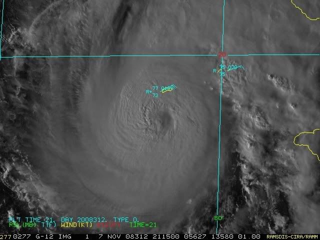
TURN PALOMA TOWARD THE NE AND ACROSS CENTRAL CUBA AND INTO THE S
BAHAMAS LATE THIS WEEKEND (REFER TO LATEST TRACK GUIDANCE FROM NHC).

FOR THE SHORT TERM...TONIGHT THROUGH SUN...THE SURFACE RIDGE OVER
CENTRAL FLA MOVES EAST...PUSHED BY THE COLD FRONT ASSOCIATED WITH
THE UPPER TROUGH. THE FRONT MOVES INTO N FLA OVER NIGHT...SLOWS
...STALLS AND EVENTUALLY DISSIPATES OVER CENTRAL FLA SUN. AS THE
FRONT WANES...PALOMA MOVES ACROSS CENTRAL CUBA AND INTO THE SW
N ATLC EARLY SUN. AFFECTS FROM PALOMA THOUGH BEGIN TO BE FELT IN
S FLA BY LATE TONIGHT AND INTO EARLY SUN...BUT MAINLY OVER THE SE
PORTIONS OF THE CWA.
MODELS DIFFER ON EVOLUTION OF PALOMA. NAM KEEPS
SYSTEM OVER THE CARIB...NGM BRINGS IT CLOSER TO S FLA WHILE GFS
SIMILAR TO NHC TRACK AND WILL FOLLOW GFS. STILL HAVE PROBLEMS THOUGH
WITH GFS POPS AS THIS MODEL FOCUSES AND THE MID/HI LEVEL MOISTURE
TOO MUCH. WILL SHAVE POPS BUT MODEL PRECIPITATION PATTERN WILL BE
FOLLOWED
. MAX/MIN TEMPS NEAR NORMS THROUGH THE PERIOD THOUGH SUN MAX
TEMPS A SHADE COOLER. WINDS SHIFT FROM E TONIGHT TO NE SAT THEN MORE
NORTHERLY SUN AND POSSIBLY BREEZY E AS PALOMA PASSES.


http://www.srh.noaa.gov/fwd/productview ... &version=0
Last edited by gatorcane on Fri Nov 07, 2008 4:39 pm, edited 3 times in total.
0 likes   

CrazyC83
Professional-Met
Professional-Met
Posts: 34001
Joined: Tue Mar 07, 2006 11:57 pm
Location: Deep South, for the first time!

#387 Postby CrazyC83 » Fri Nov 07, 2008 4:38 pm

FL and SFMR both now support 95 kt intensity.
0 likes   

CrazyC83
Professional-Met
Professional-Met
Posts: 34001
Joined: Tue Mar 07, 2006 11:57 pm
Location: Deep South, for the first time!

#388 Postby CrazyC83 » Fri Nov 07, 2008 4:42 pm

This is starting to look similar to the November 1932 hurricane - not nearly as strong though (yet).
0 likes   

User avatar
cycloneye
Admin
Admin
Posts: 143879
Age: 68
Joined: Thu Oct 10, 2002 10:54 am
Location: San Juan, Puerto Rico

Re: ATL: PALOMA - Hurricane - Discussion

#389 Postby cycloneye » Fri Nov 07, 2008 4:45 pm

This was a cat 4 max,but I dont think Paloma will reach that.

Image
0 likes   

Derek Ortt

#390 Postby Derek Ortt » Fri Nov 07, 2008 4:45 pm

highest winds in NW quad. Passing east of Cayman is not good
0 likes   

User avatar
gatorcane
S2K Supporter
S2K Supporter
Posts: 23689
Age: 47
Joined: Sun Mar 13, 2005 3:54 pm
Location: Boca Raton, FL

Re:

#391 Postby gatorcane » Fri Nov 07, 2008 4:46 pm

Derek Ortt wrote:highest winds in NW quad. Passing east of Cayman is not good


Derek that doesn't surprise me looking at the IR shot, clearly the West side seems stronger (deeper colors on this image). No SW shear yet.

Image
Last edited by gatorcane on Fri Nov 07, 2008 4:47 pm, edited 1 time in total.
0 likes   

CrazyC83
Professional-Met
Professional-Met
Posts: 34001
Joined: Tue Mar 07, 2006 11:57 pm
Location: Deep South, for the first time!

Re: ATL: PALOMA - Hurricane - Discussion

#392 Postby CrazyC83 » Fri Nov 07, 2008 4:46 pm

cycloneye wrote:This was a cat 4 max,but I dont think Paloma will reach that.

Image


Actually, that was probably a Cat 5 based on reports of 140 kt winds and a pressure of 915mb.
0 likes   

User avatar
HURAKAN
Professional-Met
Professional-Met
Posts: 46086
Age: 38
Joined: Thu May 20, 2004 4:34 pm
Location: Key West, FL
Contact:

#393 Postby HURAKAN » Fri Nov 07, 2008 5:20 pm

Image

The eye is looking right at Grand Cayman.
0 likes   

User avatar
carolina_73
Tropical Storm
Tropical Storm
Posts: 148
Joined: Wed Jul 23, 2008 1:30 am

Re: ATL: PALOMA - Hurricane - Discussion

#394 Postby carolina_73 » Fri Nov 07, 2008 5:27 pm

Weather station at East end of Grand Cayman has updated now. The pressure is down to 995 and a 1 minute average of 54mph. The peak wind gust so far is 66mph. http://caymanchillin.com/caymanchillin-weather.html
0 likes   

CrazyC83
Professional-Met
Professional-Met
Posts: 34001
Joined: Tue Mar 07, 2006 11:57 pm
Location: Deep South, for the first time!

#395 Postby CrazyC83 » Fri Nov 07, 2008 5:27 pm

oops wrong thread
Last edited by CrazyC83 on Fri Nov 07, 2008 5:30 pm, edited 1 time in total.
0 likes   

User avatar
Tampa Bay Hurricane
Category 5
Category 5
Posts: 5597
Age: 37
Joined: Fri Jul 22, 2005 7:54 pm
Location: St. Petersburg, FL

#396 Postby Tampa Bay Hurricane » Fri Nov 07, 2008 5:28 pm

*****NOT OFFICIAL
Eastern Cayman could see max sustained winds near 115-120 mph at the rate
Paloma is deepening.
0 likes   

User avatar
Just Joshing You
Category 2
Category 2
Posts: 512
Joined: Sat Nov 03, 2007 10:29 am
Location: Nova Scotia

#397 Postby Just Joshing You » Fri Nov 07, 2008 5:38 pm

OK question.

Can someone post how many AHI steps Paloma passed? Not saying she is Annular, but just want to know how many steps, and if any, which.
0 likes   

CrazyC83
Professional-Met
Professional-Met
Posts: 34001
Joined: Tue Mar 07, 2006 11:57 pm
Location: Deep South, for the first time!

#398 Postby CrazyC83 » Fri Nov 07, 2008 5:42 pm

Current Intensity Analysis


UW - CIMSS
ADVANCED DVORAK TECHNIQUE
ADT-Version 7.2.3
Tropical Cyclone Intensity Algorithm

----- Current Analysis -----
Date : 07 NOV 2008 Time : 214500 UTC
Lat : 18:43:01 N Lon : 81:06:50 W


CI# /Pressure/ Vmax
5.6 / 959.3mb/104.6kt


Final T# Adj T# Raw T#
(3hr avg)
5.6 6.0 6.0

Latitude bias adjustment to MSLP : +1.7mb

Estimated radius of max. wind based on IR :N/A km

Center Temp : -41.9C Cloud Region Temp : -69.5C

Scene Type : EYE

Positioning Method : SPIRAL ANALYSIS

Ocean Basin : ATLANTIC
Dvorak CI > MSLP Conversion Used : ATLANTIC

Tno/CI Rules : Constraint Limits : NO LIMIT
Weakening Flag : OFF
Rapid Dissipation Flag : OFF
0 likes   

User avatar
Tampa Bay Hurricane
Category 5
Category 5
Posts: 5597
Age: 37
Joined: Fri Jul 22, 2005 7:54 pm
Location: St. Petersburg, FL

#399 Postby Tampa Bay Hurricane » Fri Nov 07, 2008 5:45 pm

Watching recon closely to see if the 104 kt 120 mph estimate verifies...and also
praying for the Caymans people.
0 likes   

User avatar
DESTRUCTION5
Category 5
Category 5
Posts: 4423
Age: 43
Joined: Wed Sep 03, 2003 11:25 am
Location: Stuart, FL

#400 Postby DESTRUCTION5 » Fri Nov 07, 2008 5:52 pm

Paloma is just stunning looking for a Nov storm...Makes you want to do a double take at the calendar...
0 likes   


Return to “2008”

Who is online

Users browsing this forum: No registered users and 38 guests