http://cimss.ssec.wisc.edu/tropic/real- ... t48hrs.gif
Seems the hurricane senses the island and moves east with a jerky movement. Trough
influence more prominent at that point.
Now moving NE or NNE or something like that. Trough influence prominent.
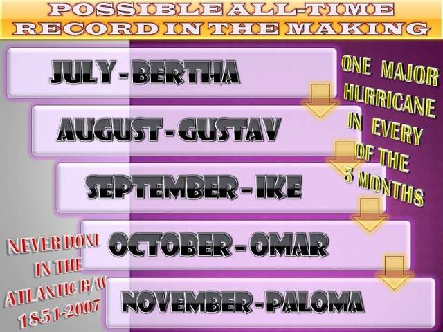
ATL: PALOMA - Tropical Depression - Discussion
Moderator: S2k Moderators
-
Tampa Bay Hurricane

- Category 5

- Posts: 5597
- Age: 38
- Joined: Fri Jul 22, 2005 7:54 pm
- Location: St. Petersburg, FL
-
cycloneye

- Admin

- Posts: 149282
- Age: 69
- Joined: Thu Oct 10, 2002 10:54 am
- Location: San Juan, Puerto Rico
Re: ATL: PALOMA - Hurricane - Discussion
AT 1000 PM EST...0300Z...THE CENTER OF MAJOR HURRICANE PALOMA WAS
LOCATED NEAR LATITUDE 19.1 NORTH...LONGITUDE 80.9 WEST OR ABOUT 25
MILES... 40 KM...SOUTHEAST OF THE EASTERN END OF GRAND CAYMAN AND
ABOUT 65 MILES...105 KM...SOUTHWEST OF LITTLE CAYMAN. THIS POSITION
IS ALSO ABOUT 250 MILES...405 KM...SOUTHWEST OF CAMAGUEY CUBA.
PALOMA IS MOVING TOWARD THE NORTHEAST NEAR 7 MPH...11 KM/HR...AND
THIS GENERAL MOTION IS EXPECTED TO CONTINUE FOR THE NEXT 48 HOURS.
ON THE FORECAST TRACK...THE CENTER OF PALOMA IS EXPECTED TO PASS
OVER OR NEAR LITTLE CAYMAN AND CAYMAN BRAC SATURDAY MORNING...AND
BE APPROACHING THE COAST OF CENTRAL CUBA LATE SATURDAY NIGHT OR
EARLY SUNDAY.
MAXIMUM SUSTAINED WINDS ARE NEAR 115 MPH...185 KM/HR...WITH HIGHER
GUSTS. PALOMA IS A CATEGORY THREE HURRICANE ON THE SAFFIR-SIMPSON
SCALE. SOME SLIGHT STRENGTHENING IS POSSIBLE TONIGHT AND EARLY
SATURDAY MORNING...BEFORE GRADUAL WEAKENING BEGINS BY SATURDAY
EVENING.
0 likes

-
Matt-hurricanewatcher
Re: ATL: PALOMA - Hurricane - Discussion
Looks like a cat4 to me. Wait intil the next recon and be suprized. 
0 likes


-
Tampa Bay Hurricane
- Category 5
- Posts: 5597
- Age: 38
- Joined: Fri Jul 22, 2005 7:54 pm
- Location: St. Petersburg, FL
-
wxman57

- Moderator-Pro Met

- Posts: 23172
- Age: 68
- Joined: Sat Jun 21, 2003 8:06 pm
- Location: Houston, TX (southwest)
Re: ATL: PALOMA - Hurricane - Discussion
It does look stronger than 100 kts to me. Maybe 110-115 kts? That NE jog has spared Grand Cayman some fairly strong wind. It appears the western Eyewall is only grazing the east end of the island. New NHC track looks reasonable. There really won't be anything left of Paloma to accelerate out to sea once it passes Cuba. I think shear will be so strong that it'll be ripped apart as it emerges north of Cuba. The last advisory will probably be written on Monday.
0 likes
-
Tampa Bay Hurricane
- Category 5
- Posts: 5597
- Age: 38
- Joined: Fri Jul 22, 2005 7:54 pm
- Location: St. Petersburg, FL
Re: ATL: PALOMA - Hurricane - Discussion
wxman57 wrote:It does look stronger than 100 kts to me. Maybe 110-115 kts? That NE jog has spared Grand Cayman some fairly strong wind. It appears the western Eyewall is only grazing the east end of the island. New NHC track looks reasonable. There really won't be anything left of Paloma to accelerate out to sea once it passes Cuba. I think shear will be so strong that it'll be ripped apart as it emerges north of Cuba. The last advisory will probably be written on Monday.
I agree it looks 115 kt, and shear is like 100 kts north of cuba and will eat this thing.
Would the left over moisture move west toward florida (after it is dead)? Kinda like
a harmless ghost at that point in 5 days.
0 likes


-
Tampa Bay Hurricane
- Category 5
- Posts: 5597
- Age: 38
- Joined: Fri Jul 22, 2005 7:54 pm
- Location: St. Petersburg, FL
Re: ATL: PALOMA - Hurricane - Discussion
We have 'coneage' in south florida..and thankfully we are not talking right now anything more than a spritz, a breeze, and a cold front gone 'poof'

Last edited by jinftl on Fri Nov 07, 2008 10:16 pm, edited 1 time in total.
0 likes

Re: ATL: PALOMA - Hurricane - Discussion
Satellite presentation is great. SSD is at 6.0, and the ADT from CIMSS has been hovering around 6.6/6.7 the last few hours. Just another 2.5 hours till recon...wxman57 wrote:It does look stronger than 100 kts to me. Maybe 110-115 kts? That NE jog has spared Grand Cayman some fairly strong wind. It appears the western Eyewall is only grazing the east end of the island. New NHC track looks reasonable. There really won't be anything left of Paloma to accelerate out to sea once it passes Cuba. I think shear will be so strong that it'll be ripped apart as it emerges north of Cuba. The last advisory will probably be written on Monday.
0 likes
-
Crostorm

- Category 5
- Posts: 2060
- Age: 51
- Joined: Mon Dec 25, 2006 3:51 pm
- Location: Croatia-Europe
- Contact:
Re: ATL: PALOMA - Hurricane - Discussion
UW - CIMSS
ADVANCED DVORAK TECHNIQUE
ADT-Version 7.2.3
Tropical Cyclone Intensity Algorithm
----- Current Analysis -----
Date : 08 NOV 2008 Time : 021500 UTC
Lat : 18:59:54 N Lon : 80:47:28 W
CI# /Pressure/ Vmax
6.3 / 941.8mb/122.2kt
Final T# Adj T# Raw T#
(3hr avg)
6.3 6.6 6.6
Latitude bias adjustment to MSLP : +1.6mb
Estimated radius of max. wind based on IR : 20 km
Center Temp : +11.6C Cloud Region Temp : -69.1C
Scene Type : EYE
Positioning Method : RING/SPIRAL COMBINATION
Ocean Basin : ATLANTIC
Dvorak CI > MSLP Conversion Used : ATLANTIC
Tno/CI Rules : Constraint Limits : NO LIMIT
Weakening Flag : OFF
Rapid Dissipation Flag : OFF
****************************************************
0 likes
Re: ATL: PALOMA - Hurricane - Discussion
NWS Miami translation of what this all means for se fl in terms of the forecast...
NWS Forecast for: Miami FL
Issued by: National Weather Service Miami - South Florida
Last Update: 9:52 pm EST Nov 7, 2008
Saturday: A 20 percent chance of showers after 8am. Mostly cloudy, with a high near 80. North wind between 10 and 14 mph, with gusts as high as 21 mph.
Saturday Night: A 30 percent chance of showers. Mostly cloudy, with a low around 70. North wind between 13 and 15 mph, with gusts as high as 25 mph.
Sunday: A 20 percent chance of showers. Mostly cloudy, with a high near 79. Breezy, with a north wind between 17 and 20 mph, with gusts as high as 32 mph.
Sunday Night: Isolated showers. Partly cloudy, with a low around 68. Windy, with a north wind between 18 and 21 mph, with gusts as high as 33 mph. Chance of precipitation is 20%.
Monday: A 20 percent chance of showers. Partly cloudy, with a high near 80. Breezy, with a north wind around 18 mph, with gusts as high as 29 mph.
Last edited by jinftl on Fri Nov 07, 2008 10:23 pm, edited 1 time in total.
0 likes
-
Tampa Bay Hurricane
- Category 5
- Posts: 5597
- Age: 38
- Joined: Fri Jul 22, 2005 7:54 pm
- Location: St. Petersburg, FL
Re: ATL: PALOMA - Hurricane - Discussion
jinftl wrote:NWS Miami translation of what this all means for se fl in terms of the forecast...
NWS Forecast for: Miami FL
Issued by: National Weather Service Miami - South Florida
Last Update: 9:52 pm EST Nov 7, 2008
Saturday: A 20 percent chance of showers after 8am. Mostly cloudy, with a high near 80. North wind between 10 and 14 mph, with gusts as high as 21 mph.
Saturday Night: A 30 percent chance of showers. Mostly cloudy, with a low around 70. North wind between 13 and 15 mph, with gusts as high as 25 mph.
Sunday: A 20 percent chance of showers. Mostly cloudy, with a high near 79. Breezy, with a north wind between 17 and 20 mph, with gusts as high as 32 mph.
Sunday Night: Isolated showers. Partly cloudy, with a low around 68. Windy, with a north wind between 18 and 21 mph, with gusts as high as 33 mph. Chance of precipitation is 20%.
Monday: A 20 percent chance of showers. Partly cloudy, with a high near 80. Breezy, with a north wind around 18 mph, with gusts as high as 29 mph.
The remnant low "ghost of Paloma" will make it breeezy across South Florida...33 mph. Thank goodness for shear.
0 likes
Re: ATL: PALOMA - Hurricane - Discussion
Cayman Brac is smaller and more vulnerable. This turn is not good for them.
0 likes
-
Tampa Bay Hurricane
- Category 5
- Posts: 5597
- Age: 38
- Joined: Fri Jul 22, 2005 7:54 pm
- Location: St. Petersburg, FL
Re: ATL: PALOMA - Hurricane - Discussion
winds are coming around from the NNW in grand cayman meaning they probably have escaped the brunt of this storm as i thought earlier.
0 likes

Who is online
Users browsing this forum: No registered users and 188 guests