Some info from Grand Cayman
: Updated -- 8:00 pm Friday: CUC says residents in the following areas across Grand Cayman are experiencing outages: various areas within downtown Georgetown; various areas immediately south of downtown Georgetown; Crew Road Bypass through Prospect Point Road to Spotts, Savannah, Savannah Meadows, Lower Valley, Beach Bay; all of North Side from Rum Point to Morritts.
CUC will continue efforts to reroute power and re-establish service. However, high winds make safe response by line crews very limited and a spokesperson for the company said they would have to wait for winds to abate to conduct a full physical investigation of faults. CUC is not presently aware of any extensive damage to equipment and generation services at the North Sound Plant are unaffected.
CAL: Cayman Airways has announced that operations are now suspended in the Cayman Islands due to the rapid approach of Hurricane Paloma and the reservations offices in Miami remain open to accomodate passenger queries.
Water: The Water Authority has now shut don its supply to all customers and all customers are urged to keep listening to the radio for updates from the Water Authority as well as to visit the website at http://www.waterauthority.ky Cayman Water which supplies the West Bay area however has said it will try to maintain the supply for as long as possible.
For more details of shelters and of the storm's path please also see CNS lead story at: cayman-battens-down
Banks: The Cayman Island Clearing Banks has announced that all member Banks will be closed on Friday November 7, and will not re-open until the Hazard Management Cayman Islands’ Joint Communications Service (JCS) has issued their ‘all clear’ bulletin. The Cayman Islands Clearing Banks consist of the following members: Butterfield Bank (Cayman), Cayman National Bank, FirstCaribbean International Bank (Cayman), Royal Bank of Canada, Scotiabank & Trust (Cayman), Fidelity Bank (Cayman), HSBC (Cayman).
Supermarkets and stores: All stores, shops and supermarkets on Grand Cayman are now closed and will remains closed untill the all clear is given.
The Cayman Islands Hospital Accident & Emergency Unit will remain open 24 hours for emergency medical treatment. However, ambulances are unable to respond to calls after the onset of tropical storm force winds until the all clear is given.
For persons who may be emotionally vulnerable during this time the Health Services has advised that a mental health professional will be available at each shelter to offer counsel and support. It is important that those on medication ensure that they have at least one week supply available. Persons who may find themselves unable to cope should avoid isolation and are encouraged to stay with relatives and friends who are able to offer coping skills. All Mental Health Patients requiring refills should attend the Mental Health Department at the Cayman Islands Hospital between the hours of 8am and 9am tomorrow.
http://www.caymannewsservice.com/local-news/2008/11/07/paloma-preparations-and-information-update
ATL: PALOMA - Tropical Depression - Discussion
Moderator: S2k Moderators
-
vbhoutex

- Storm2k Executive

- Posts: 29146
- Age: 74
- Joined: Wed Oct 09, 2002 11:31 pm
- Location: Cypress, TX
- Contact:
Re: ATL: PALOMA - Hurricane - Discussion
EyELeSs1 wrote:winds are coming around from the NNW in grand cayman meaning they probably have escaped the brunt of this storm as i thought earlier.
If by the brunt you mean the highest winds it does appear so, but there have been unofficial reports(per NHC) of 80 mph sustained with gusts to 100 mph, which we know is nothing to sneeze at.
0 likes
Re: ATL: PALOMA - Hurricane - Discussion
Weird track here. I think this is a 45 degree turn on a dime off the front. This is headed right at Little Cayman and Cayman Brac All depends on how much punch it retains. Those islands are lower and more vulnerable than Grand Cayman. Little Cayman only has 170 permanent residents. If Paloma maintains intensity we should see eye type winds on those two Keys.
0 likes
-
dixiebreeze

- S2K Supporter

- Posts: 5140
- Joined: Wed Sep 03, 2003 5:07 pm
- Location: crystal river, fla.
Re: ATL: PALOMA - Hurricane - Discussion
WOW! 07/2345 UTC 18.8N 81.0W T6.0/6.0 PALOMA -- Atlantic
0 likes
-
Crostorm

- Category 5

- Posts: 2060
- Age: 51
- Joined: Mon Dec 25, 2006 3:51 pm
- Location: Croatia-Europe
- Contact:
Re: ATL: PALOMA - Hurricane - Discussion
Current Intensity Analysis
UW - CIMSS
ADVANCED DVORAK TECHNIQUE
ADT-Version 7.2.3
Tropical Cyclone Intensity Algorithm
----- Current Analysis -----
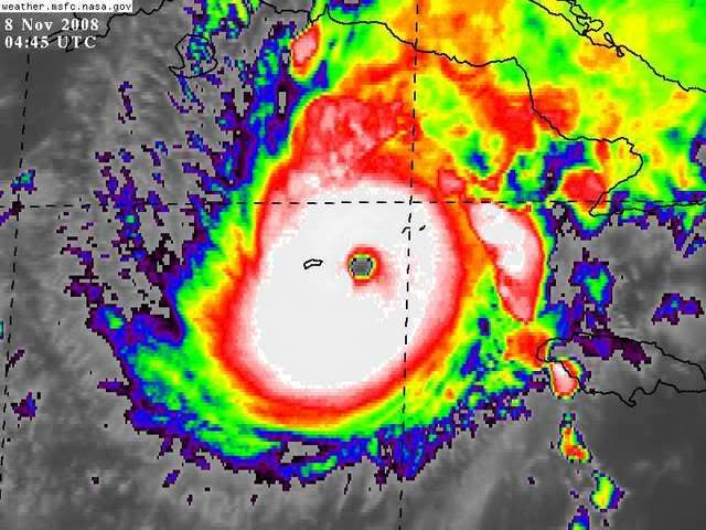
Date : 08 NOV 2008 Time : 031500 UTC
Lat : 19:04:02 N Lon : 80:43:28 W
CI# /Pressure/ Vmax
6.5 / 936.6mb/127.0kt
Final T# Adj T# Raw T#
(3hr avg)
6.5 6.7 6.7
Latitude bias adjustment to MSLP : +1.6mb
Estimated radius of max. wind based on IR : 17 km
Center Temp : +14.9C Cloud Region Temp : -70.1C
Scene Type : EYE
Positioning Method : RING/SPIRAL COMBINATION
Ocean Basin : ATLANTIC
Dvorak CI > MSLP Conversion Used : ATLANTIC
Tno/CI Rules : Constraint Limits : NO LIMIT
Weakening Flag : OFF
Rapid Dissipation Flag : OFF
****************************************************
UW - CIMSS
ADVANCED DVORAK TECHNIQUE
ADT-Version 7.2.3
Tropical Cyclone Intensity Algorithm
----- Current Analysis -----
Date : 08 NOV 2008 Time : 031500 UTC
Lat : 19:04:02 N Lon : 80:43:28 W
CI# /Pressure/ Vmax
6.5 / 936.6mb/127.0kt
Final T# Adj T# Raw T#
(3hr avg)
6.5 6.7 6.7
Latitude bias adjustment to MSLP : +1.6mb
Estimated radius of max. wind based on IR : 17 km
Center Temp : +14.9C Cloud Region Temp : -70.1C
Scene Type : EYE
Positioning Method : RING/SPIRAL COMBINATION
Ocean Basin : ATLANTIC
Dvorak CI > MSLP Conversion Used : ATLANTIC
Tno/CI Rules : Constraint Limits : NO LIMIT
Weakening Flag : OFF
Rapid Dissipation Flag : OFF
****************************************************
0 likes
-
CrazyC83
- Professional-Met

- Posts: 34315
- Joined: Tue Mar 07, 2006 11:57 pm
- Location: Deep South, for the first time!
I do agree that Recon will find a Cat 4...although we have to wait and see! I wonder if history could be made by tomorrow with the first (maybe second?) Cat 5 in November? I think it has about 12-24 hours left to strengthen before the bottom falls out...
Last edited by CrazyC83 on Fri Nov 07, 2008 11:30 pm, edited 1 time in total.
0 likes
-
Just Joshing You

- Category 2

- Posts: 512
- Joined: Sat Nov 03, 2007 10:29 am
- Location: Nova Scotia
-
CrazyC83
- Professional-Met
- Posts: 34315
- Joined: Tue Mar 07, 2006 11:57 pm
- Location: Deep South, for the first time!
Re:
Just Joshing You wrote:If it hits 7.0 *after* recon leaves, would they upgrade to Cat 5?
Probably not, unless Recon finds something very close and a reasonable case can be made.
0 likes

-
Just Joshing You
- Category 2
- Posts: 512
- Joined: Sat Nov 03, 2007 10:29 am
- Location: Nova Scotia
-
CrazyC83
- Professional-Met
- Posts: 34315
- Joined: Tue Mar 07, 2006 11:57 pm
- Location: Deep South, for the first time!
Re:
Just Joshing You wrote:What is the strongest ever November storm?
Strongest in the database is Lenny (1999), 135 kt/933mb.
However, a storm in November 1932 (currently listed with no pressure and 115 kt) had a pressure reading of 915mb and was likely at least 140 kt.
0 likes
Re: ATL: PALOMA - Hurricane - Discussion
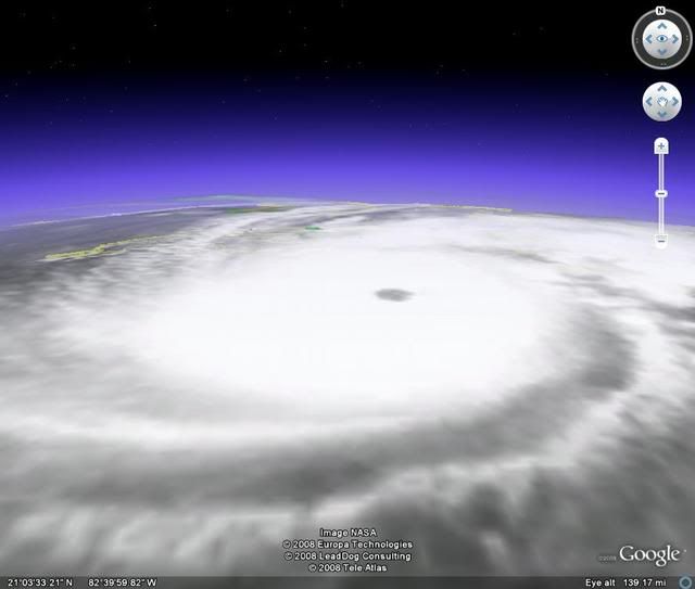
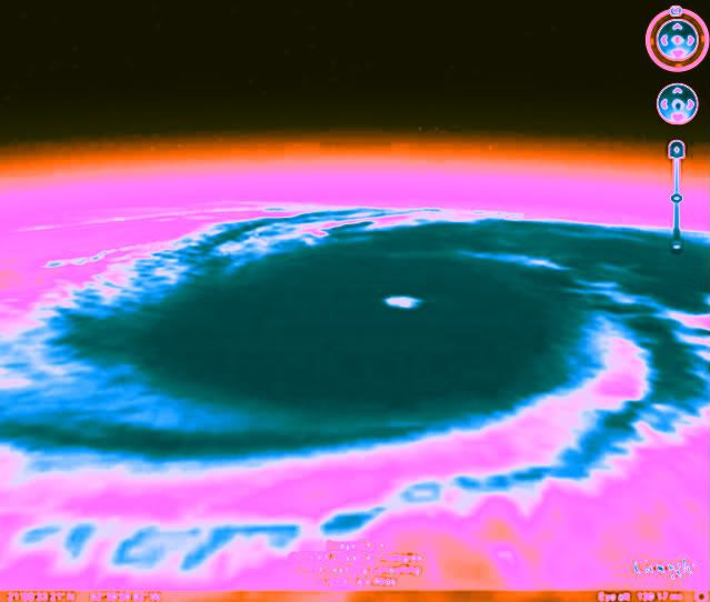
Eye tightened on shortwave. That usually means further intensification. Bad prior to Little Cayman.
0 likes

-
Squarethecircle
- Category 5
- Posts: 2165
- Joined: Fri Oct 19, 2007 4:00 pm
- Location: Fairfax, VA
Re: ATL: PALOMA - Hurricane - Discussion
This is a serious hurricane. Need reconnaissance.
Think a correction left is happening.
Think a correction left is happening.
0 likes
-
Just Joshing You
- Category 2
- Posts: 512
- Joined: Sat Nov 03, 2007 10:29 am
- Location: Nova Scotia


-
HURAKAN

- Professional-Met
- Posts: 46084
- Age: 39
- Joined: Thu May 20, 2004 4:34 pm
- Location: Key West, FL
- Contact:
HURRICANE PALOMA INTERMEDIATE ADVISORY NUMBER 10A
NWS TPC/NATIONAL HURRICANE CENTER MIAMI FL AL172008
100 AM EST SAT NOV 08 2008
...CENTER OF DANGEROUS CATEGORY THREE PALOMA APPROACHING LITTLE
CAYMAN AND CAYMAN BRAC...
REPEATING THE 100 AM EST POSITION...19.3 N...80.5 W. MOVEMENT
TOWARD...NORTHEAST NEAR 8 MPH. MAXIMUM SUSTAINED WINDS...120 MPH.
MINIMUM CENTRAL PRESSURE...958 MB.
FORECASTER BEVEN/BRENNAN
0 likes
Who is online
Users browsing this forum: No registered users and 64 guests