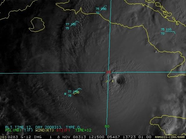
ATL: PALOMA - Tropical Depression - Discussion

Moderator: S2k Moderators

Message
Author
User avatar
Gustywind
Category 5
Category 5
Posts: 12334
Joined: Mon Sep 03, 2007 7:29 am
Location: Baie-Mahault, GUADELOUPE

Re: Re:

#561 Postby Gustywind » Sat Nov 08, 2008 7:18 am

caribepr wrote:
Gustywind wrote:
You're right Hurak, absolutely in the books my friend, history-wise!!!! Excuse me if the sense of my sentence was so doubtfull. Sincerely you know me, how can we say that a monster cane it's a pleasant event for the Caymans islands???? It's a nightmare for all the islands in the path.... :( :cry: :eek:


Gusty, *smooch*! I was/am just feeling really sad for them...I knew you knew.

Yeah me too remembering sadly Omar scenario, oh it's hard for them, let's pray... :)
0 likes   

User avatar
Blown Away
S2K Supporter
S2K Supporter
Posts: 10140
Joined: Wed May 26, 2004 6:17 am

Re: ATL: PALOMA - Hurricane - Discussion

#562 Postby Blown Away » Sat Nov 08, 2008 7:27 am

Chris_in_Tampa wrote:Cayman Brac live obs:
http://www.neoc.gov.ky/CYB/index.html
Main: http://www.neoc.gov.ky/


This station reporting Cat 1 sustained with Cat 3 gusts, pressure going up and winds are starting to come down a little. Hopefully that was the most this island got.
0 likes   

User avatar
Gustywind
Category 5
Category 5
Posts: 12334
Joined: Mon Sep 03, 2007 7:29 am
Location: Baie-Mahault, GUADELOUPE

Re: ATL: PALOMA - Hurricane - Discussion

#563 Postby Gustywind » Sat Nov 08, 2008 7:30 am

Blown_away wrote:
Chris_in_Tampa wrote:Cayman Brac live obs:
http://www.neoc.gov.ky/CYB/index.html
Main: http://www.neoc.gov.ky/


This station reporting Cat 1 sustained with Cat 3 gusts, pressure going up and winds are starting to come down a little. Hopefully that was the most this island got.

:eek: :eek: TKANKS nice and pertinent info guy :wink:
0 likes   

User avatar
HURAKAN
Professional-Met
Professional-Met
Posts: 46086
Age: 38
Joined: Thu May 20, 2004 4:34 pm
Location: Key West, FL
Contact:

#564 Postby HURAKAN » Sat Nov 08, 2008 7:34 am

Image
0 likes   

User avatar
Tampa Bay Hurricane
Category 5
Category 5
Posts: 5597
Age: 37
Joined: Fri Jul 22, 2005 7:54 pm
Location: St. Petersburg, FL

#565 Postby Tampa Bay Hurricane » Sat Nov 08, 2008 7:43 am

Devastating eyewall near the islands...praying for those people
0 likes   

User avatar
TampaFl
S2K Supporter
S2K Supporter
Posts: 1904
Age: 67
Joined: Thu Sep 04, 2003 11:23 am
Location: Tampa, FL

Re: ATL: PALOMA - Hurricane - Discussion

#566 Postby TampaFl » Sat Nov 08, 2008 7:52 am

Last edited by TampaFl on Sat Nov 08, 2008 8:01 am, edited 1 time in total.
0 likes   

User avatar
MGC
S2K Supporter
S2K Supporter
Posts: 5885
Joined: Sun Mar 23, 2003 9:05 pm
Location: Pass Christian MS, or what is left.

Re: ATL: PALOMA - Hurricane - Discussion

#567 Postby MGC » Sat Nov 08, 2008 7:57 am

Incredible hurricane for November or any time. Praying for the people in the Cayman's and Cuba. Don't look like the shear will arrive in time to spare Cuba.....MGC
0 likes   

User avatar
Chacor
Category 5
Category 5
Posts: 10229
Joined: Mon Oct 02, 2006 10:43 pm
Location: Singapore

#568 Postby Chacor » Sat Nov 08, 2008 7:59 am

Code: Select all

TCCA22 KNHC 081251
STDCCA

SATELLITE TROPICAL DISTURBANCE RAINFALL ESTIMATES
NWS TPC/NATIONAL HURRICANE CENTER MIAMI FL
1215 UTC SAT NOV  8 2008


SYSTEM NAME/IDENTIFIER...PALOMA

                                             MAX RAINFALL
  DATE/TIME      LOCATION       MOTION      MEAN      LAST
 -----------   ------------     ------     -------   -------
  8/1215 UTC   19.7N  79.7W     045/06     17.8 IN   14.4 IN


LAST RAINFALL DISTRIBUTION...

     DISTANCE          LEFT OF CENTER      RIGHT OF CENTER
   -------------      ---------------      ---------------
   0 TO 1 DEGREE       6.7 TO 12.3 IN      10.4 TO 14.4 IN
   1 TO 2 DEGREE       0.9 TO  6.5 IN       2.9 TO 14.3 IN
   2 TO 3 DEGREE       0.0 TO  0.8 IN       0.3 TO  2.3 IN
   3 TO 4 DEGREE       0.0 TO  0.5 IN       0.0 TO  2.3 IN


                        ...LEGEND...

SYSTEM NAME/IDENTIFIER...NAME OR NUMBER ASSIGNED TO SYSTEM
                         (E.G. TROPICAL STORM ALPHA, TROPICAL
                         DISTURBANCE 01, SURFACE TROUGH)

DATE/TIME...             DAY OF MONTH AND TIME IN UNIVERSAL TIME
                         COORDINATES (UTC) IN A DY/HRMN FORMAT

LOCATION...              ESTIMATED CENTER OF SYSTEM OR ADVISORY
                         POSITION FOR TROPICAL CYCLONE IN TENTHS
                         OF DEGREES OF LATITUDE AND LONGITUDE

MOTION...                ESTIMATED DIRECTION AND SPEED OF SYSTEM
                         IN DEGREES AND KNOTS

MEAN MAXIMUM RAINFALL... THE 24-HOUR MEAN MAXIMUM ACCUMULATION OF
                         RAINFALL FOR THE SYSTEM IN INCHES BASED
                         ON FOUR SATELLITE IMAGES SIX HOURS APART

LAST MAXIMUM RAINFALL... THE MAXIMUM ACCUMULATION OF RAINFALL FOR
                         THE SYSTEM IN INCHES BASED ON THE MOST
                         RECENT SATELLITE IMAGE

RAINFALL DISTRIBUTION... THE DISTRIBUTION OF RAINFALL WITHIN FOUR
                         DEGREES (240 NM) LEFT AND RIGHT OF THE
                         SYSTEM CENTER IN ONE DEGREE (60NM)
                         INCREMENTS...LOOKING DOWNSTREAM
                         (1 IN = 25.4 MM)
0 likes   

User avatar
TampaFl
S2K Supporter
S2K Supporter
Posts: 1904
Age: 67
Joined: Thu Sep 04, 2003 11:23 am
Location: Tampa, FL

Re: ATL: PALOMA - Hurricane - Discussion

#569 Postby TampaFl » Sat Nov 08, 2008 7:59 am

0 likes   

User avatar
wxman57
Moderator-Pro Met
Moderator-Pro Met
Posts: 22951
Age: 67
Joined: Sat Jun 21, 2003 8:06 pm
Location: Houston, TX (southwest)

Re: ATL: PALOMA - Hurricane - Discussion

#570 Postby wxman57 » Sat Nov 08, 2008 8:03 am


That link takes minutes to work, and it's best not to make such a hot link to an external web page. You can really tax their server over there and make the S2K page load slowly. Just snap a picture, upload it, and post it and/or post the URL to the loop.

Here's the URL:
http://www.insmet.cu/asp/genesis.asp?TB ... B1=RADARES

Here's the radar image:
Image
0 likes   

User avatar
Weatherfreak14
Category 5
Category 5
Posts: 1383
Joined: Sat Sep 24, 2005 3:40 pm
Location: Beaufort, SC
Contact:

Re: ATL: PALOMA - Hurricane - Discussion

#571 Postby Weatherfreak14 » Sat Nov 08, 2008 8:04 am

MGC wrote:Incredible hurricane for November or any time. Praying for the people in the Cayman's and Cuba. Don't look like the shear will arrive in time to spare Cuba.....MGC


Right now im in pretty much disbelief, when is the shear suppossed to start to rip this thing apart????
0 likes   

User avatar
Blown Away
S2K Supporter
S2K Supporter
Posts: 10140
Joined: Wed May 26, 2004 6:17 am

Re: ATL: PALOMA - Hurricane - Discussion

#572 Postby Blown Away » Sat Nov 08, 2008 8:06 am

Image

I'm trying to figure out if I'm on some drugs looking at this graphic.
0 likes   

User avatar
TampaFl
S2K Supporter
S2K Supporter
Posts: 1904
Age: 67
Joined: Thu Sep 04, 2003 11:23 am
Location: Tampa, FL

Re: ATL: PALOMA - Hurricane - Discussion

#573 Postby TampaFl » Sat Nov 08, 2008 8:10 am

wxman57 wrote:


That link takes minutes to work, and it's best not to make such a hot link to an external web page. You can really tax their server over there and make the S2K page load slowly. Just snap a picture, upload it, and post it and/or post the URL to the loop.

Here's the URL:
http://www.insmet.cu/asp/genesis.asp?TB ... B1=RADARES

Here's the radar image:
Image


Thanks Wxman57 for the advice & information - did not no that. Learn something new everyday. :D

Robert 8-)
0 likes   

User avatar
wxman57
Moderator-Pro Met
Moderator-Pro Met
Posts: 22951
Age: 67
Joined: Sat Jun 21, 2003 8:06 pm
Location: Houston, TX (southwest)

Re: ATL: PALOMA - Hurricane - Discussion

#574 Postby wxman57 » Sat Nov 08, 2008 8:15 am

Blown_away wrote:http://img526.imageshack.us/img526/5308/93luf0.jpg

I'm trying to figure out if I'm on some drugs looking at this graphic.


The 5-day cone is actually a series of error circles centered on each forecast point. At the 5-day forecast point, this circle is 800 miles across. Typically, the circles aren't drawn as different shaded and translucent, so you won't see the full circle. And when a storm slows down, the "cone" becomes that error circle.

With Paloma, there won't be much left of it beyond 72 hours. I doubt that remnant swirl of clouds will even exist out to day 5.

However, it's possible you could be on drugs.
0 likes   

KBBOCA
S2K Supporter
S2K Supporter
Posts: 1559
Joined: Fri Sep 05, 2003 5:27 am
Location: Formerly Boca Raton, often West Africa. Currently Charlotte NC

Re: ATL: PALOMA - Hurricane - Discussion

#575 Postby KBBOCA » Sat Nov 08, 2008 8:19 am

So how many landfalls would this make for Cuba this season? This has to be something like #5 or 6? Incredible. Poor Cuba. Praying for them. What's the record for one island or state being hit with hurricanes in a given season? Just devastating to look at this storm.
0 likes   

User avatar
Dionne
S2K Supporter
S2K Supporter
Posts: 1616
Age: 73
Joined: Mon Jan 02, 2006 8:51 am
Location: SW Mississippi....Alaska transplant via a Southern Belle.

Re: ATL: PALOMA - Hurricane - Discussion

#576 Postby Dionne » Sat Nov 08, 2008 8:28 am

Did Little Cayman just take a direct hit from the eyewall?
0 likes   

User avatar
cycloneye
Admin
Admin
Posts: 143889
Age: 68
Joined: Thu Oct 10, 2002 10:54 am
Location: San Juan, Puerto Rico

Re: ATL: PALOMA - Hurricane - Discussion

#577 Postby cycloneye » Sat Nov 08, 2008 8:30 am

Image
0 likes   

User avatar
HURAKAN
Professional-Met
Professional-Met
Posts: 46086
Age: 38
Joined: Thu May 20, 2004 4:34 pm
Location: Key West, FL
Contact:

Re: ATL: PALOMA - Hurricane - Discussion

#578 Postby HURAKAN » Sat Nov 08, 2008 8:31 am

Dionne wrote:Did Little Cayman just take a direct hit from the eyewall?


Image
0 likes   

User avatar
cycloneye
Admin
Admin
Posts: 143889
Age: 68
Joined: Thu Oct 10, 2002 10:54 am
Location: San Juan, Puerto Rico

Re: ATL: PALOMA - Hurricane - Discussion

#579 Postby cycloneye » Sat Nov 08, 2008 8:40 am


UW - CIMSS
ADVANCED DVORAK TECHNIQUE
ADT-Version 7.2.3
Tropical Cyclone Intensity Algorithm

----- Current Analysis -----
Date : 08 NOV 2008 Time : 124500 UTC
Lat : 19:45:58 N Lon : 79:28:38 W


CI# /Pressure/ Vmax
6.7 / 930.8mb/132.2kt


Final T# Adj T# Raw T#
(3hr avg)
6.7 6.7 6.7

Latitude bias adjustment to MSLP : +1.4mb

Estimated radius of max. wind based on IR : 17 km

Center Temp : +14.5C Cloud Region Temp : -69.6C

Scene Type : EYE

Positioning Method : RING/SPIRAL COMBINATION

Ocean Basin : ATLANTIC
Dvorak CI > MSLP Conversion Used : ATLANTIC

Tno/CI Rules : Constraint Limits : NO LIMIT
Weakening Flag : OFF
Rapid Dissipation Flag : OFF

http://cimss.ssec.wisc.edu/tropic2/real ... dt17L.html
0 likes   

User avatar
tomboudreau
Category 5
Category 5
Posts: 1869
Age: 48
Joined: Tue Feb 18, 2003 6:07 pm
Location: Carnegie, PA
Contact:

#580 Postby tomboudreau » Sat Nov 08, 2008 8:43 am

Looks like she is continued to strengthen then with those numbers? Don't want to say this, but if the trend continues, could she become a Cat 5 storm? Where oh where is the shear that is forecasted to enter the picture?
0 likes   


Return to “2008”

Who is online

Users browsing this forum: No registered users and 34 guests