Australian Government Bureau of Meteorology
Western Australia
Media: The Standard Emergency Warning Signal should NOT be used with this
warning.
TOP PRIORITY FOR IMMEDIATE BROADCAST
TROPICAL CYCLONE ADVICE NUMBER 6
Issued at 9:50 am WDT on Wednesday, 19 November 2008
BY THE BUREAU OF METEOROLOGY
TROPICAL CYCLONE WARNING CENTRE PERTH
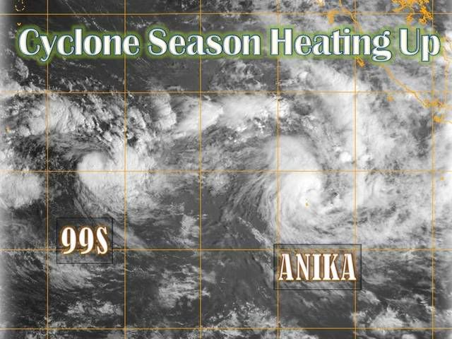
A Cyclone WARNING is current for the Cocos Islands.
At 9:00 am WDT Tropical Cyclone Anika was estimated to be
215 kilometres north northwest of Cocos Island and
moving east at 29 kilometres per hour.
Tropical Cyclone Anika has formed to the north of the Cocos Islands and is
expected to maintain an east to southeast movement over the next few days.
Gales with wind gusts to 100 kilometres per hour could develop over the Cocos
Islands today as the tropical cyclone passes to the north of the Islands.
Details of Tropical Cyclone Anika at 9:00 am WDT:
.Centre located near...... 10.3 degrees South 96.4 degrees East
.Location accuracy........ within 45 kilometres
.Recent movement.......... towards the east at 29 kilometres per hour
.Wind gusts near centre... 100 kilometres per hour
.Severity category........ 1
.Central pressure......... 995 hectoPascals
The next advice will be issued by 1:00 pm WDT Wednesday 19 November.
This advice is available by dialling 1300 659 210.
A map showing the track of the cyclone is available at:
http://www.bom.gov.au/weather/cyclone
SIO: Ex Tropical Cyclone Anika (02S)
Moderator: S2k Moderators

-
HURAKAN

- Professional-Met

- Posts: 46084
- Age: 39
- Joined: Thu May 20, 2004 4:34 pm
- Location: Key West, FL
- Contact:
Australian Government Bureau of Meteorology
Western Australia
Media: The Standard Emergency Warning Signal should NOT be used with this
warning.
TOP PRIORITY FOR IMMEDIATE BROADCAST
TROPICAL CYCLONE ADVICE NUMBER 8
Issued at 3:45 pm WDT on Wednesday, 19 November 2008
BY THE BUREAU OF METEOROLOGY
TROPICAL CYCLONE WARNING CENTRE PERTH
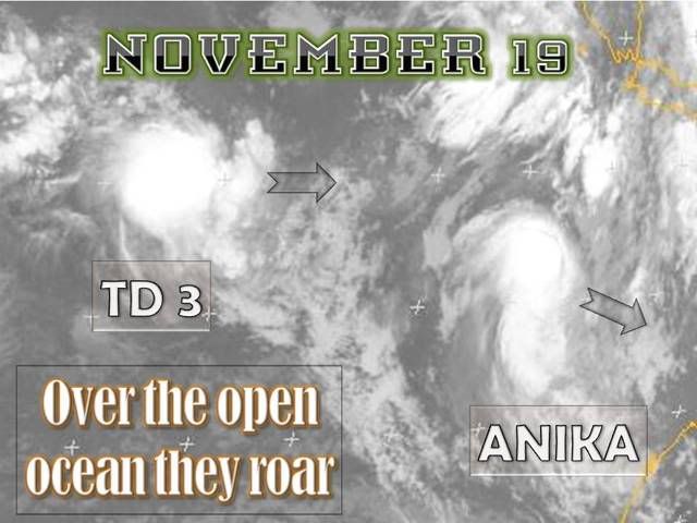
The Cyclone WARNING for the Cocos Islands has been CANCELLED.
At 3:00 pm WDT Tropical Cyclone Anika was estimated to be
170 kilometres northeast of Cocos Island and
moving east southeast at 29 kilometres per hour.
Tropical Cyclone Anika is located to the northeast of the Cocos Islands and is
expected to continue moving away from the islands on an east to southeast track.
Gales with wind gusts to 100 kilometres per hour are no longer expected at the
Cocos Islands.
Details of Tropical Cyclone Anika at 3:00 pm WDT:
.Centre located near...... 11.2 degrees South 98.0 degrees East
.Location accuracy........ within 45 kilometres
.Recent movement.......... towards the east southeast at 29 kilometres per hour
.Wind gusts near centre... 100 kilometres per hour
.Severity category........ 1
.Central pressure......... 993 hectoPascals
No further advices will be issued for this system.
This advice is available by dialling 1300 659 210.
A map showing the track of the cyclone is available at:
http://www.bom.gov.au/weather/cyclone
Western Australia
Media: The Standard Emergency Warning Signal should NOT be used with this
warning.
TOP PRIORITY FOR IMMEDIATE BROADCAST
TROPICAL CYCLONE ADVICE NUMBER 8
Issued at 3:45 pm WDT on Wednesday, 19 November 2008
BY THE BUREAU OF METEOROLOGY
TROPICAL CYCLONE WARNING CENTRE PERTH
The Cyclone WARNING for the Cocos Islands has been CANCELLED.
At 3:00 pm WDT Tropical Cyclone Anika was estimated to be
170 kilometres northeast of Cocos Island and
moving east southeast at 29 kilometres per hour.
Tropical Cyclone Anika is located to the northeast of the Cocos Islands and is
expected to continue moving away from the islands on an east to southeast track.
Gales with wind gusts to 100 kilometres per hour are no longer expected at the
Cocos Islands.
Details of Tropical Cyclone Anika at 3:00 pm WDT:
.Centre located near...... 11.2 degrees South 98.0 degrees East
.Location accuracy........ within 45 kilometres
.Recent movement.......... towards the east southeast at 29 kilometres per hour
.Wind gusts near centre... 100 kilometres per hour
.Severity category........ 1
.Central pressure......... 993 hectoPascals
No further advices will be issued for this system.
This advice is available by dialling 1300 659 210.
A map showing the track of the cyclone is available at:
http://www.bom.gov.au/weather/cyclone
0 likes

IDW27600
TROPICAL CYCLONE TECHNICAL BULLETIN: AUSTRALIA - WESTERN REGION
Issued by PERTH TROPICAL CYCLONE WARNING CENTRE
at: 0630 UTC 19/11/2008
Name: Anika
Data At: 0600 UTC
Latitude: 11.2S
Longitude: 98.0E
Location Accuracy: within 30 nm [55 km]
Movement Towards: east southeast [117 deg]
Speed of Movement: 15 knots [29 km/h]
Maximum 10-Minute Wind: 40 knots [75 km/h]
Maximum 3-Second Wind Gust: 55 knots [100 km/h]
Central Pressure: 993 hPa
Radius of 34-knot winds NE quadrant: 80 nm [150 km]
Radius of 34-knot winds SE quadrant: 60 nm [110 km]
Radius of 34-knot winds SW quadrant: 60 nm [110 km]
Radius of 34-knot winds NW quadrant: 80 nm [150 km]
Radius of 48-knot winds NE quadrant:
Radius of 48-knot winds SE quadrant:
Radius of 48-knot winds SW quadrant:
Radius of 48-knot winds NW quadrant:
Radius of 64-knot winds:
Radius of Maximum Winds: 15 nm [28 km]
Dvorak Intensity Code: T3.0/3.0/D1.0/24HRS
Pressure of outermost isobar: 1002 hPa
Radius of outermost closed isobar: 60 nm [110 km]
Storm Depth: Deep
FORECAST DATA
Date/Time : Location : Loc. Accuracy: Max Wind : Central Pressure
[UTC] : degrees : nm [km]: knots[km/h]: hPa
+12: 19/1800: 12.0S 100.1E: 060 [110]: 050 [095]: 986
+24: 20/0600: 13.0S 101.9E: 090 [165]: 055 [100]: 983
+36: 20/1800: 13.9S 103.4E: 120 [225]: 050 [095]: 985
+48: 21/0600: 14.5S 104.8E: 155 [285]: 045 [085]: 989
+60: 21/1800: 15.1S 107.0E: 200 [375]: 035 [065]: 996
+72: 22/0600: 15.5S 109.5E: 250 [465]: 030 [055]: 998
REMARKS:
The system developed rapidly over the last 24 hours. Most convection is located
on the western side of the system due to moderate NE shear. Based on a curved
band or shear pattern a DT 3.0 has been assigned. The system is expected to
develop over the next 24 hours and then begin to weaken as it moves over cooler
SST's and experiences an increase in wind shear due to the approach of a
mid-level trough.
==
The next bulletin for this system will be issued by: 19/1300 UTC by Perth TCWC.
0 likes
-
HurricaneBill
- Category 5

- Posts: 3419
- Joined: Sun Apr 11, 2004 5:51 pm
- Location: East Longmeadow, MA, USA
Re: SIO: Tropical Cyclone Anika (02S)
Whenever I hear the name Anika, all I can think of is the girl from the Pippi Longstocking movies.

0 likes
AXAU01 APRF 191305
IDW27600
TROPICAL CYCLONE TECHNICAL BULLETIN: AUSTRALIA - WESTERN REGION
Issued by PERTH TROPICAL CYCLONE WARNING CENTRE
at: 1305 UTC 19/11/2008
Name: Anika
Data At: 1200 UTC
Latitude: 11.9S
Longitude: 99.0E
Location Accuracy: within 30 nm [55 km]
Movement Towards: east southeast [115 deg]
Speed of Movement: 13 knots [24 km/h]
Maximum 10-Minute Wind: 40 knots [75 km/h]
Maximum 3-Second Wind Gust: 55 knots [100 km/h]
Central Pressure: 995 hPa
Radius of 34-knot winds NE quadrant: 80 nm [150 km]
Radius of 34-knot winds SE quadrant: 60 nm [110 km]
Radius of 34-knot winds SW quadrant: 60 nm [110 km]
Radius of 34-knot winds NW quadrant: 80 nm [150 km]
Radius of 48-knot winds NE quadrant:
Radius of 48-knot winds SE quadrant:
Radius of 48-knot winds SW quadrant:
Radius of 48-knot winds NW quadrant:
Radius of 64-knot winds:
Radius of Maximum Winds: 15 nm [28 km]
Dvorak Intensity Code: T3.0/3.0/D1.0/24HRS
Pressure of outermost isobar: 1004 hPa
Radius of outermost closed isobar: 100 nm [185 km]
Storm Depth: Deep
FORECAST DATA
Date/Time : Location : Loc. Accuracy: Max Wind : Central Pressure
[UTC] : degrees : nm [km]: knots[km/h]: hPa
+12: 20/0000: 13.3S 101.0E: 060 [110]: 050 [095]: 988
+24: 20/1200: 14.5S 103.0E: 090 [165]: 055 [100]: 985
+36: 21/0000: 15.4S 104.7E: 120 [225]: 050 [095]: 987
+48: 21/1200: 16.2S 106.8E: 155 [285]: 045 [085]: 991
+60: 22/0000: 16.5S 109.1E: 200 [375]: 035 [065]: 996
+72: 22/1200: 16.7S 110.9E: 250 [465]: 030 [055]: 999
REMARKS:
Anika has developed steadily in the last 24 hours. Convection has been located
on the western side of the system consistent with the prevailing moderate NE
shear. The 07UTC microwave imagery showed a tight low level cloud signature and
recent IR images seem to indicate increased convection near the centre.
Dvorak: CI=DT=3.0 based on time averaged shear pattern, although there is some
uncertainty in overnight positioning.
The recent increase in convection is consistent with the expectation of
intensification overnight.
The system is expected to develop over the next 24 hours and then begin to
weaken as it experiences an increase in wind shear due to the approach of a
mid-level trough.
==
The next bulletin for this system will be issued by: 19/1900 UTC by Perth TCWC.
0 likes
-
HURAKAN
- Professional-Met
- Posts: 46084
- Age: 39
- Joined: Thu May 20, 2004 4:34 pm
- Location: Key West, FL
- Contact:
HIGH SEAS WEATHER WARNING FOR METAREA 10 ISSUED BY THE
AUSTRALIAN BUREAU OF METEOROLOGY TROPICAL CYCLONE WARNING
CENTRE PERTH AT 1302UTC 19 NOVEMBER 2008
STORM FORCE WIND WARNING FOR THE WESTERN AREA
Please be aware, wind gusts can be a further 40 percent stronger than the
averages given here, and maximum waves may be up to twice the height.
SITUATION
At 1200 UTC Tropical Cyclone Anika was centred within 30 nautical miles of
latitude eleven decimal nine south [11.9S]
longitude ninety nine decimal zero east [99.0E]
Recent movement : east southeast at 13 knot
Maximum winds : 40 knots
Central pressure: 995 hPa
AREA AFFECTED
Within 80 nautical miles in NE quadrant
and within 60 nautical miles in SE quadrant
and within 60 nautical miles in SW quadrant
and within 80 nautical miles in NW quadrant.
FORECAST
Maximum winds to 40 knots near the centre increasing to 55 knots by 1200 UTC 20
November.
Winds above 48 knots within 20 nautical miles of centre after 1800 UTC 19
November with very rough seas and moderate swell.
Winds above 34 knots within 80 nautical miles with rough seas and moderate
swell.
Forecast positions
At 0000 UTC 20 November: Within 60 nautical miles of 13.3 south 101.0 east
Central pressure 988 hPa.
Winds to 50 knots near centre.
At 1200 UTC 20 November: Within 90 nautical miles of 14.5 south 103.0 east
Central pressure 985 hPa.
Winds to 55 knots near centre.
REMARKS
All ships in the area please send weather reports every three hours.
Regular weather observing ships use normal channels.
Other ships please use either email to tcwcwa@bom.gov.au or fax to +61892632261
or satellite to SAC 1241 through Land Earth Station Perth 312.
Next warning will be issued by 1900 UTC 19 November 2008.
WEATHER PERTH
0 likes


-
HURAKAN
- Professional-Met
- Posts: 46084
- Age: 39
- Joined: Thu May 20, 2004 4:34 pm
- Location: Key West, FL
- Contact:
HIGH SEAS WEATHER WARNING FOR METAREA 10 ISSUED BY THE
AUSTRALIAN BUREAU OF METEOROLOGY TROPICAL CYCLONE WARNING
CENTRE PERTH AT 1909UTC 19 NOVEMBER 2008
STORM FORCE WIND WARNING FOR THE WESTERN AREA
Please be aware, wind gusts can be a further 40 percent stronger than the
averages given here, and maximum waves may be up to twice the height.
SITUATION
At 1800 UTC Tropical Cyclone Anika was centred within 30 nautical miles of
latitude twelve decimal five south [12.5S]
longitude one hundred decimal three east [100.3E]
Recent movement : east southeast at 14 knot
Maximum winds : 45 knots
Central pressure: 994 hPa
AREA AFFECTED
Within 90 nautical miles in NE quadrant
and within 60 nautical miles in SE quadrant
and within 60 nautical miles in SW quadrant
and within 80 nautical miles in NW quadrant.
FORECAST
Maximum winds to 45 knots near the centre increasing to 50 knots by 1800 UTC 20
November.
Winds above 48 knots within 20 nautical miles of centre after 1800 UTC 19
November with very rough seas and moderate swell.
Winds above 34 knots within 90 nautical miles with rough seas and moderate
swell.
Forecast positions
At 0600 UTC 20 November: Within 60 nautical miles of 13.9 south 102.4 east
Central pressure 991 hPa.
Winds to 50 knots near centre.
At 1800 UTC 20 November: Within 90 nautical miles of 15.0 south 104.4 east
Central pressure 990 hPa.
Winds to 50 knots near centre.
REMARKS
All ships in the area please send weather reports every three hours.
Regular weather observing ships use normal channels.
Other ships please use either email to tcwcwa@bom.gov.au or fax to +61892632261
or satellite to SAC 1241 through Land Earth Station Perth 312.
Next warning will be issued by 0100 UTC 20 November 2008.
WEATHER PERTH
0 likes


-
HURAKAN
- Professional-Met
- Posts: 46084
- Age: 39
- Joined: Thu May 20, 2004 4:34 pm
- Location: Key West, FL
- Contact:
Re: SIO: Tropical Cyclone Anika (02S)

TROPICAL CYCLONE TECHNICAL BULLETIN: AUSTRALIA - WESTERN REGION
Issued by PERTH TROPICAL CYCLONE WARNING CENTRE
at: 0100 UTC 20/11/2008
Name: Anika
Data At: 0000 UTC
Latitude: 13.2S
Longitude: 101.5E
Location Accuracy: within 30 nm [55 km]
Movement Towards: east southeast [121 deg]
Speed of Movement: 14 knots [25 km/h]
Maximum 10-Minute Wind: 50 knots [95 km/h]
Maximum 3-Second Wind Gust: 70 knots [130 km/h]
Central Pressure: 991 hPa
Radius of 34-knot winds NE quadrant: 90 nm [165 km]
Radius of 34-knot winds SE quadrant: 90 nm [165 km]
Radius of 34-knot winds SW quadrant: 90 nm [165 km]
Radius of 34-knot winds NW quadrant: 90 nm [165 km]
Radius of 48-knot winds NE quadrant: 40 nm [75 km]
Radius of 48-knot winds SE quadrant: 40 nm [75 km]
Radius of 48-knot winds SW quadrant: 40 nm [75 km]
Radius of 48-knot winds NW quadrant: 40 nm [75 km]
Radius of 64-knot winds:
Radius of Maximum Winds: 20 nm [37 km]
Dvorak Intensity Code: T3.5/3.5/D0.5/24HRS
Pressure of outermost isobar: 1006 hPa
Radius of outermost closed isobar: 120 nm [220 km]
Storm Depth: Deep
FORECAST DATA
Date/Time : Location : Loc. Accuracy: Max Wind : Central Pressure
[UTC] : degrees : nm [km]: knots[km/h]: hPa
+12: 20/1200: 14.6S 104.0E: 060 [110]: 050 [095]: 991
+24: 21/0000: 15.8S 106.0E: 090 [165]: 040 [075]: 997
+36: 21/1200: 16.3S 108.1E: 120 [225]: 035 [065]: 999
+48: 22/0000: 16.5S 110.2E: 155 [285]: 030 [055]: 1002
+60: 22/1200: 16.5S 111.7E: 200 [375]: 030 [055]: 1001
+72: 23/0000: 15.8S 113.0E: 250 [465]: 030 [055]: 1001
REMARKS:
The 2220UTC SSMIS microwave image shows deep convection wrapping around the
middle level centre. This supports the intensification into a Category 2
cyclone. The system however continues to experience moderate N/NW shear.
Dvorak: CI=DT=3.5 based on 0.8 wrap and time averaged shear pattern.
Anika is likely to weaken overnight as moves into cooler SSTs south of 15S.
Upper level winds are also forecast to increase due to the influence of an upper
level trough to the south.
==
The next bulletin for this system will be issued by: 20/0700 UTC by Perth TCWC.
0 likes
-
HURAKAN
- Professional-Met
- Posts: 46084
- Age: 39
- Joined: Thu May 20, 2004 4:34 pm
- Location: Key West, FL
- Contact:
TPXS11 PGTW 200013
A. TROPICAL CYCLONE 02S (ANIKA)
B. 19/2330Z
C. 13.6S
D. 101.4E
E. THREE/MTSAT
F. T4.0/4.0/D1.5/24HRS STT: D0.5/06HRS
G. IR/EIR/VIS/MSI
H. REMARKS: 15A/PBO BANDING EYE/ANMTN. CONVECTION WRAP OF 1.10
ON LOG 10 YIELDS A DT OF 4.0. MET AND PT AGREE. DBO DT.
I. ADDITIONAL POSITIONS:
19/1858Z 12.9S 100.5E AMSU
AMES
0 likes
-
HURAKAN
- Professional-Met
- Posts: 46084
- Age: 39
- Joined: Thu May 20, 2004 4:34 pm
- Location: Key West, FL
- Contact:
HIGH SEAS WEATHER WARNING FOR METAREA 10 ISSUED BY THE
AUSTRALIAN BUREAU OF METEOROLOGY TROPICAL CYCLONE WARNING
CENTRE PERTH AT 0657UTC 20 NOVEMBER 2008
STORM FORCE WIND WARNING FOR THE WESTERN AREA
Please be aware, wind gusts can be a further 40 percent stronger than the
averages given here, and maximum waves may be up to twice the height.
SITUATION
At 0600 UTC Tropical Cyclone Anika was centred within 30 nautical miles of
latitude fourteen decimal zero south [14.0S]
longitude one hundred and two decimal four east [102.4E]
Recent movement : southeast at 12 knots
Maximum winds : 50 knots
Central pressure: 990 hPa
AREA AFFECTED
Within 70 nautical miles in NE quadrant
and within 90 nautical miles in SE quadrant
and within 70 nautical miles in SW quadrant
and within 40 nautical miles in NW quadrant.
FORECAST
Maximum winds to 50 knots near the centre easing to 40 knots by 0600 UTC 21
November.
Winds above 48 knots within 30 nautical miles of centre until 1800 UTC 20
November with very rough to high seas and moderate swell.
Winds above 34 knots within 70 nautical miles in NE quadrant
and within 90 nautical miles in SE quadrant
and within 70 nautical miles in SW quadrant
and within 40 nautical miles in NW quadrant with rough seas and moderate
swell.
Forecast positions
At 1800 UTC 20 November: Within 60 nautical miles of 15.2 south 104.3 east
Central pressure 990 hPa.
Winds to 50 knots near centre.
At 0600 UTC 21 November: Within 90 nautical miles of 16.4 south 106.2 east
Central pressure 997 hPa.
Winds to 40 knots near centre.
REMARKS
All ships in the area please send weather reports every three hours.
Regular weather observing ships use normal channels.
Other ships please use either email to tcwcwa@bom.gov.au or fax to +61892632261
or satellite to SAC 1241 through Land Earth Station Perth 312.
Next warning will be issued by 1300 UTC 20 November 2008.
WEATHER PERTH
0 likes
Who is online
Users browsing this forum: No registered users and 85 guests