Southern Plains winter wx thread (2008-2009)

Winter Weather Discussion

Moderator: S2k Moderators

Forum rules

The posts in this forum are NOT official forecast and should not be used as such. They are just the opinion of the poster and may or may not be backed by sound meteorological data. They are NOT endorsed by any professional institution or STORM2K.

Help Support Storm2K
Message
Author
Ed Mahmoud

Re: Several cold shots on the horizon (Plains and East)

#141 Postby Ed Mahmoud » Tue Nov 18, 2008 12:29 pm

Extremeweatherguy wrote:The latest GFS MOS guidance (12z) looks pretty chilly for OKC late this week and this weekend. It is showing a high of 54F on Thursday, 47F on Friday, 46F on Saturday, and 52F on Sunday. These numbers are not exceptionally cold, but they would still make for a nice cool down if they play out..especially since we are expecting a high into the 70s tomorrow!


Look at Dallas on December 1st. 12Z run seems to agree with 6Z run on a winter weather event of small to moderate magnitude. Looks to me like GFS is predicting near 2 inches of snow, mainly during the overnight hours when the sun won't be heating the ground.

Code: Select all

2 M     850     SFC     SFC     700    3/6      500    1000
TMP     TMP     PRS     RHU     RHU     HR      HGT     500
(C)     (C)    (MB)    (PCT)   (PCT)   (IN)    (DM)     THK

MON 00Z 01-DEC   3.8     0.0    1019      70      97    0.04     560     544   
MON 12Z 01-DEC   0.9    -2.8    1019      93      89    0.18     555     539   
0 likes   

Dean4Storms
S2K Supporter
S2K Supporter
Posts: 6358
Age: 62
Joined: Sun Aug 31, 2003 1:01 pm
Location: Miramar Bch. FL

Re: Several cold shots on the horizon (Plains and East)

#142 Postby Dean4Storms » Tue Nov 18, 2008 7:53 pm

Ed Mahmoud wrote:
Extremeweatherguy wrote:The latest GFS MOS guidance (12z) looks pretty chilly for OKC late this week and this weekend. It is showing a high of 54F on Thursday, 47F on Friday, 46F on Saturday, and 52F on Sunday. These numbers are not exceptionally cold, but they would still make for a nice cool down if they play out..especially since we are expecting a high into the 70s tomorrow!


Look at Dallas on December 1st. 12Z run seems to agree with 6Z run on a winter weather event of small to moderate magnitude. Looks to me like GFS is predicting near 2 inches of snow, mainly during the overnight hours when the sun won't be heating the ground.

Code: Select all

2 M     850     SFC     SFC     700    3/6      500    1000
TMP     TMP     PRS     RHU     RHU     HR      HGT     500
(C)     (C)    (MB)    (PCT)   (PCT)   (IN)    (DM)     THK

MON 00Z 01-DEC   3.8     0.0    1019      70      97    0.04     560     544   
MON 12Z 01-DEC   0.9    -2.8    1019      93      89    0.18     555     539   


I saw that, it develops a low in the central GOM and tracks it toward central Florida bringing a snow/ice threat event across the deep south from mid- south MS eastward toward mid-south GA.
0 likes   

User avatar
Extremeweatherguy
Category 5
Category 5
Posts: 11095
Joined: Mon Oct 10, 2005 8:13 pm
Location: Florida

#143 Postby Extremeweatherguy » Thu Nov 20, 2008 12:23 pm

We have a pretty chilly forecast here in OKC over the next two days...

This Afternoon: Mostly sunny, with a high near 47. Windy, with a north wind 29 to 32 mph decreasing to between 20 and 23 mph. Winds could gust as high as 45 mph.

Tonight: Mostly clear, with a low around 25. North northeast wind between 7 and 15 mph, with gusts as high as 21 mph.

Friday: Sunny, with a high near 47. Northeast wind 7 to 14 mph becoming south southeast. Winds could gust as high as 18 mph.

Friday Night: Mostly clear, with a low around 30. South southeast wind between 10 and 13 mph.


Tonight's low of 25F will be our coldest low temperature so far this season.

-------------------------------------------------------------------------------------------------

UPDATE (3:00pm): The NWS has now lowered our forecasted low to 24F.
0 likes   

User avatar
Extremeweatherguy
Category 5
Category 5
Posts: 11095
Joined: Mon Oct 10, 2005 8:13 pm
Location: Florida

#144 Postby Extremeweatherguy » Fri Nov 21, 2008 8:31 am

BRRR! It got colder than forecast last night. According to the Oklahoma Mesonet, parts of OKC are as cold as 18-22F this morning!

:cold:
0 likes   

Ed Mahmoud

Re:

#145 Postby Ed Mahmoud » Fri Nov 21, 2008 10:29 am

Extremeweatherguy wrote:BRRR! It got colder than forecast last night. According to the Oklahoma Mesonet, parts of OKC are as cold as 18-22F this morning!

:cold:


Is that cold enough to kill fire ants?


I don't know what the magic temperature is for that. Does OKC have fire ants?
0 likes   

User avatar
Extremeweatherguy
Category 5
Category 5
Posts: 11095
Joined: Mon Oct 10, 2005 8:13 pm
Location: Florida

Re: Re:

#146 Postby Extremeweatherguy » Fri Nov 21, 2008 10:45 am

Ed Mahmoud wrote:
Extremeweatherguy wrote:BRRR! It got colder than forecast last night. According to the Oklahoma Mesonet, parts of OKC are as cold as 18-22F this morning!

:cold:


Is that cold enough to kill fire ants?


I don't know what the magic temperature is for that. Does OKC have fire ants?
I have not seen any fire ants personally, but according to this image ( http://www.ars.usda.gov/fireant/images/ ... ation2.jpg ), it looks like OKC is at the very northern edge of where they can be found.
0 likes   

Ed Mahmoud

Re: Cold weather (Plains and East)

#147 Postby Ed Mahmoud » Fri Nov 21, 2008 2:14 pm

Snow flurries for EWG????

Image
0 likes   

User avatar
Extremeweatherguy
Category 5
Category 5
Posts: 11095
Joined: Mon Oct 10, 2005 8:13 pm
Location: Florida

Re: Cold weather (Plains and East)

#148 Postby Extremeweatherguy » Fri Nov 21, 2008 3:02 pm

Ed Mahmoud wrote:Snow flurries for EWG????

Image
That is way out on December 6th, and the models shouldn't be trusted so far out, but it certainly is possible. Snow in Oklahoma during the month of December is not too uncommon, and will probably occur at least once in OKC during the first 2 weeks of the month. I can't wait!
0 likes   

User avatar
Extremeweatherguy
Category 5
Category 5
Posts: 11095
Joined: Mon Oct 10, 2005 8:13 pm
Location: Florida

#149 Postby Extremeweatherguy » Fri Nov 21, 2008 3:26 pm

In one of Joe Bastardi's videos today he said that he expects a : "major, prolonged arctic outbreak [to come] to the United States the 5th-15th of December". He thinks this arctic blast will be colder and more widespread than the one we are currently experiencing.

---------------------------------------------------------------------------------------------------------

The 18z GFS seems to agree with this idea somewhat. It is showing a pretty cold looking 500mb pattern setting up over the country by early December: http://www.nco.ncep.noaa.gov/pmb/nwprod ... 0_276s.gif
Last edited by Extremeweatherguy on Fri Nov 21, 2008 5:46 pm, edited 1 time in total.
0 likes   

Johnny
Category 5
Category 5
Posts: 1428
Joined: Thu Jul 10, 2003 1:35 pm
Location: No Snow For You, Texas

Re: Cold weather (Plains and East)

#150 Postby Johnny » Fri Nov 21, 2008 4:22 pm

Just got through cancelling my JB subscription. All he talks about 98% of the time is the cold/winter in the east and hardly talks about us here in the southern states. Even when their is a threat of cold weather or wintry precip down this way, he doesn't spend much time on it at all. It's a waiste of money for me but I can see how the east coasters can benefit from his rants.
0 likes   

User avatar
iorange55
Category 5
Category 5
Posts: 2388
Joined: Thu Nov 13, 2008 9:47 pm
Location: Big D

Re: Cold weather (Plains and East)

#151 Postby iorange55 » Fri Nov 21, 2008 9:36 pm

It's already down to 37 at my house, I wonder if it's going to get colder tonight than expected.
0 likes   

User avatar
amawea
S2K Supporter
S2K Supporter
Posts: 385
Age: 73
Joined: Mon Aug 09, 2004 3:36 pm
Location: Horseshoe Bend, Ar. but from Baytown, Tx

Re: Cold weather (Plains and East)

#152 Postby amawea » Fri Nov 21, 2008 11:28 pm

What Johnnyy said about J.B. I had a paid subsription for several years but I dropped it because he was so sensitive to any e-mail that didn't agree with him. I wrote him once about flip flopping with the models after his forecast were way wrong and his response was, "then why do do subsrcribe to my site." He lost this subsription that day.
Also he does stick with a bias for the northeast in his forecasting. Geez. Why would I want to pay for something that doesn't include my area every day!

Before that, I had always been very complimentary of him thru e-mails and told him how much my Dad liked his forecast. Well my Dad died but still bragged on J.B. till the end. when I e-mailed him at that time there was no response. I know he blocked my e-mail because of one or two disagreements. He can stick it!
!
0 likes   

User avatar
vbhoutex
Storm2k Executive
Storm2k Executive
Posts: 29096
Age: 73
Joined: Wed Oct 09, 2002 11:31 pm
Location: Cypress, TX
Contact:

Re: Cold weather (Plains and East)

#153 Postby vbhoutex » Sat Nov 22, 2008 12:07 am

Back to the subject of the thread and off of JB please.
0 likes   

User avatar
Extremeweatherguy
Category 5
Category 5
Posts: 11095
Joined: Mon Oct 10, 2005 8:13 pm
Location: Florida

#154 Postby Extremeweatherguy » Sat Nov 22, 2008 12:48 am

Tonight's 00z run of the GFS continues to feature a very cold looking 500mb pattern to start the month of December...

http://www.nco.ncep.noaa.gov/pmb/nwprod ... 0_276s.gif
0 likes   

User avatar
Portastorm
Storm2k Moderator
Storm2k Moderator
Posts: 9914
Age: 62
Joined: Fri Jul 11, 2003 9:16 am
Location: Round Rock, TX
Contact:

Re:

#155 Postby Portastorm » Sat Nov 22, 2008 7:44 am

Extremeweatherguy wrote:Tonight's 00z run of the GFS continues to feature a very cold looking 500mb pattern to start the month of December...

http://www.nco.ncep.noaa.gov/pmb/nwprod ... 0_276s.gif


The Euro appears to concur with this, too!

ImageImage
0 likes   

jinftl
Category 5
Category 5
Posts: 4312
Joined: Tue Aug 31, 2004 4:47 pm
Location: fort lauderdale, fl

Re: Cold weather (Plains and East)

#156 Postby jinftl » Sat Nov 22, 2008 10:45 am

Usually when I post a CPC Outlooks and it shows Above Normal Temps across the area of the country where posters live, it is met with the ‘I don’t buy the CPC outlooks’….i am curious to see the response to this graphic…

Image

Note, however, that the daily average of 55 deg (for ex. High/low of 65/45) is north of New Orleans, Houston. And Jacksonville...below normal doesn't necessarily mean snow drifts on bourbon street.

But cold without much precip is like no-alcohol beer…what’s the point? But CPC forecasting normal precip for the most part in the east so we will see...

Image


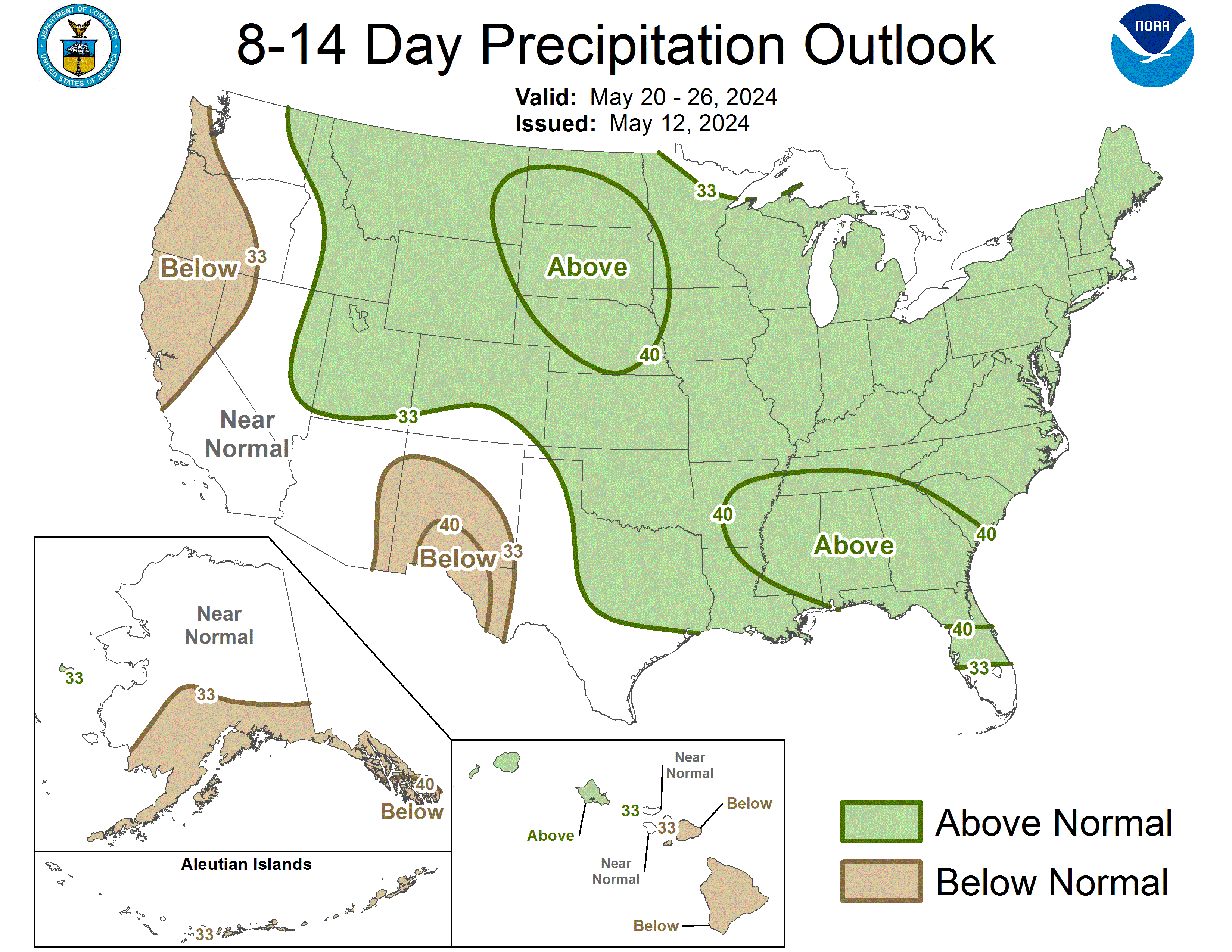
CPC also released December 2008 outlook on Thursday….

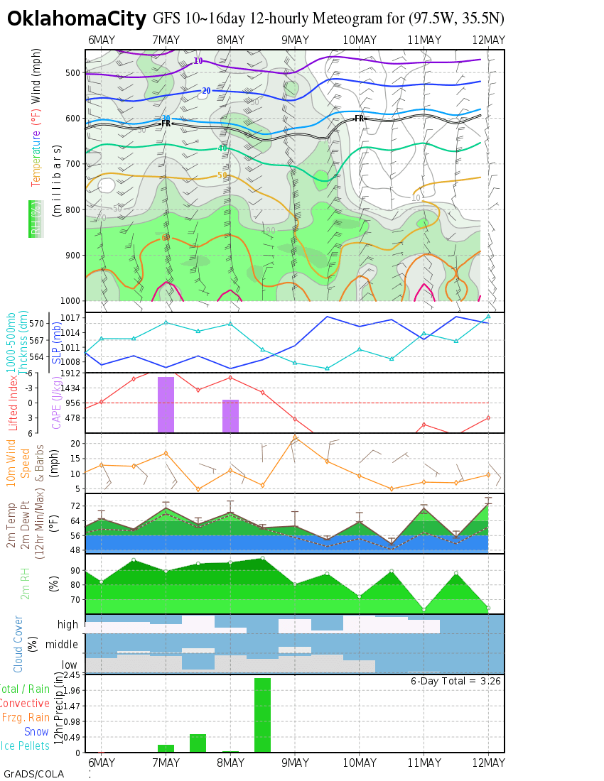
PROGNOSTIC DISCUSSION FOR MONTHLY OUTLOOK
NWS CLIMATE PREDICTION CENTER CAMP SPRINGS MD
830 AM EST THU NOV 20 2008

30-DAY OUTLOOK DISCUSSION FOR DECEMBER 2008

SEA SURFACE TEMPERATURES (SSTS) IN THE CENTRAL EQUATORIAL PACIFIC OCEAN ARE
NEAR LONG-TERM AVERAGE VALUES. SSTS IN THE NINO 3.4 REGION OF THE PACIFIC
(170W TO 120W AND 5N TO 5S) AVERAGED ABOUT .2 DEGREES C BELOW NORMAL IN THE
FIRST HALF OF NOVEMBER. ATMOSPHERIC CONDITIONS IN THE TROPICAL PACIFIC OCEAN
ARE CONSISTENT WITH ENSO-NEUTRAL CONDITIONS, WITH WIND AND CONVECTIVE PATTERNS
IN THE FEW WEEKS REFLECTIVE OF A WEAK MADDEN-JULIAN OSCILLATION (MJO). THE
MAJORITY OF SST PREDICTION MODELS PREDICT NINO 3.4 SSTS TO REMAIN SLIGHTLY
BELOW NORMAL THROUGH DECEMBER, BUT TO REMAIN WITHIN .5 C OF NORMAL, INDICATING
ENSO NEUTRAL CONDITIONS WILL CONTINUE THROUGH THE END OF THE YEAR. MJO
ACTIVITY IS EXPECTED TO REMAIN WEAK SO NO SIGNIFICANT PREDICTABLE IMPACTS ARE
EXPECTED AT THIS TIME FROM EITHER ENSO OR THE MJO.

THE TEMPERATURE OUTLOOK INDICATES ABOVE NORMAL TEMPERATURES FROM THE SOUTHERN
ROCKIES TO THE UPPER MISSISSIPPI VALLEY. THIS AREA IS SUPPORTED TO SOME EXTENT
BY CFS, CCA AND OCN FORECASTS, ALTHOUGH EXPECTED SKILL ON A 30-DAY PERIOD IS
QUITE LOW, SO THE SLIGHTLY ENHANCED CHANCES OF ABOVE NORMAL TEMPERATURES MOSTLY
REFLECT MORE CONFIDENT SIGNALS FROM THE DJF SEASONAL OUTLOOK. THE OCN TOOL
SUGGEST TRENDS FOR ABOVE NORMAL TEMPEARATURES IN CENTRAL AND NORTHERN ALASKA.

THE PRECIPITATION OUTLOOK CALLS FOR BELOW MEDIAN PRECIPITATION FOR THE SOUTHERN
U.S. FROM SOUTHERN NEW MEXICO TO THE SOUTHEASTERN STATES. THIS MAINLY REFLECTS
THE CFS FORECAST, ALTHOUGH THERE IS ADDITIONAL SUPPORT IMPLIED FROM THE DJF
FORECASTS FROM THE CCA, SMLR, OCN, CFS AND CLIMATE MODELS RUN AT OTHER CENTERS.
ABOVE MEDIAN PRECIPITATION IS INDICATED BY THE CFS FOR THE NORTHERN ROCKIES.
AN AREA OF ABOVE MEDIAN PRECIPITATION IS INDICATED FOR PARTS OF THE SOUTHERN
GREAT PLAINS FROM OCN AND SMLR FORECASTS.


Image


Image
0 likes   

User avatar
Extremeweatherguy
Category 5
Category 5
Posts: 11095
Joined: Mon Oct 10, 2005 8:13 pm
Location: Florida

#157 Postby Extremeweatherguy » Sat Nov 22, 2008 11:02 am

VERY interesting discussion from the Norman, OK NWS office this morning. They are beginning to agree that a big time cold and winter precipitation threat could loom on the horizon in the day 10 to 14 period for the southern plains...

AREA FORECAST DISCUSSION
NATIONAL WEATHER SERVICE NORMAN OK
550 AM CST SAT NOV 22 2008

.UPDATE...
ALTHOUGH IT IS BEYOND OUR 7-DAY FORECAST... WE ARE LOOKING CLOSELY
AT INCREASING POTENTIAL FOR ARCTIC/POLAR INTRUSION AND/OR
FREEZING/FROZEN PRECIP IN THE 10-14 DAY RANGE. 00Z GFS AT 240H
DEPICTED AN IMPRESSIVE UPPER RIDGE NEAR THE W COAST - 579 HIGH AT
500MB OVER SE AK COAST - AND SFC HIGHS OF 1043-1045MB LINING UP
FROM BC TO N OF AK. 00Z ECMWF HAS SOME SIMILARITIES WITH RIDGING
N-WARD FROM A 593 HIGH OFF W COAST TO THE BERING STRAIT... BUT
WITH A BREAK IN THE RISGE NEAR AK AND NW CANADA. 06Z GFS HAS TAKEN
THE 00Z THEME AND RUN WITH IT... SHOWING A MASSIVE FULL-LATITUDE
RIDGE AND 583 HIGH NEAR 140W N TO INSIDE THE ARCTIC CIRCLE N OF
AK. SFC HIGH OVER NW CANADA HAS BLOSSOMED TO 1060MB WITH ARCTIC
FRONT INTO CENTRAL PLAINS BY 12/2 06Z. POCKETS OF SUB-500
THICKNESSES STRETCH FROM SIBERIA TO N POLE TO W CANADA BY THEN.
UPPER PATTERN IS SUGGESTIVE OF AN OMEGA BLOCK... WITH NEG HEIGHT
ANOMALIES DOWNSTREAM OF THE RIDGE OVER THE ROCKIES. GEFS EXTENSION
BEYOND 240H... AVAILABLE AT EMC WEBSITE... BREAKS DOWN THE RIDGE
BEFORE THE POLAR AIR CAN LAUNCH A FULL ASSAULT INTO THE LOWER 48.
LATEST CPC 6-10 AND 8-14 DAY FORECASTS HAVE OK/NTX IN ABOVE-
NORMAL PRECIP AND BELOW-NORMAL TEMPS. NOT EASY TO TRUST THE MED-
RANGE MODELS AFTER RECENT INCONSISTENCIES... BUT GIVEN THE
POTENTIAL FOR AT LEAST SOME FORM OF CANADIAN AIR TO PUSH S THROUGH
THE PLAINS... AND POSSIBLE SHORTWAVES COMING OUT OF A TROUGH OVER
THE INLAND W... COLD AND WET IS QUITE REASONABLE WITH SOME
ENHANCED POTENTIAL FOR SNOW/ICE DURING 1ST WEEK OF DECEMBER. WILL
NEED TO WATCH THIS.


:cold: :froze: :cold: :froze:
0 likes   

User avatar
Portastorm
Storm2k Moderator
Storm2k Moderator
Posts: 9914
Age: 62
Joined: Fri Jul 11, 2003 9:16 am
Location: Round Rock, TX
Contact:

Re: Arctic blast to start December??? (Plains and East)

#158 Postby Portastorm » Sat Nov 22, 2008 11:30 am

EWG, we should also be watching not only the strength of the Arctic high pressure but the trajectory. As pro mets like Wxman57 and Air Force Met have educated us over the years, if that high comes into the US more into Minnesota and the Dakotas the bulk of it will probably hit northeast and east of the Southern Plains. However, if it comes in over the spine of the Rockies or even down the eastern slopes, we will be in business!

Both the GFS and Euro right now look to be suggested a pattern that would be hitting us squarely in the Southern Plains. Will need to watch for sure.

(Portastorm now digging through his closest looking for his kicking cleats)
0 likes   

User avatar
southerngale
Retired Staff
Retired Staff
Posts: 27418
Joined: Thu Oct 10, 2002 1:27 am
Location: Southeast Texas (Beaumont area)

Re: Arctic blast to start December??? (Plains and East)

#159 Postby southerngale » Sat Nov 22, 2008 12:37 pm

Portastorm wrote:EWG, we should also be watching not only the strength of the Arctic high pressure but the trajectory. As pro mets like Wxman57 and Air Force Met have educated us over the years, if that high comes into the US more into Minnesota and the Dakotas the bulk of it will probably hit northeast and east of the Southern Plains. However, if it comes in over the spine of the Rockies or even down the eastern slopes, we will be in business!

Both the GFS and Euro right now look to be suggested a pattern that would be hitting us squarely in the Southern Plains. Will need to watch for sure.

(Portastorm now digging through his closest looking for his kicking cleats)

Image
0 likes   

jinftl
Category 5
Category 5
Posts: 4312
Joined: Tue Aug 31, 2004 4:47 pm
Location: fort lauderdale, fl

Re: Arctic blast to start December??? (Plains and East)

#160 Postby jinftl » Sat Nov 22, 2008 1:04 pm

A large expanse of snowpack is a factor in really allowing for arctic intrusions to produce colder temps further south into the u.s....compared to last year at this time, we have about 30% less snowpack in the lower 48....13.9% this year vs 19.6% a year ago. Northern New England and the Rockies are way behind the snowpack they had a year ago...the Lake Effect regions are way ahead.
http://www.nohrsc.noaa.gov/nsa/

Image


Image
0 likes   


Return to “Winter Weather”

Who is online

Users browsing this forum: No registered users and 60 guests