Southern Plains winter wx thread (2008-2009)

Winter Weather Discussion

Moderator: S2k Moderators

Forum rules

The posts in this forum are NOT official forecast and should not be used as such. They are just the opinion of the poster and may or may not be backed by sound meteorological data. They are NOT endorsed by any professional institution or STORM2K.

Help Support Storm2K
Message
Author
User avatar
iorange55
Category 5
Category 5
Posts: 2388
Joined: Thu Nov 13, 2008 9:47 pm
Location: Big D

Re:

#401 Postby iorange55 » Wed Dec 10, 2008 2:02 am

Extremeweatherguy wrote:00z GFS is showing a 1050mb+ high pressure area coming into the northern plains next Monday...

http://www.nco.ncep.noaa.gov/pmb/nwprod ... n_138l.gif

...looks like the model might be slowly starting to catch on.

UPDATE: In the end this run still winds up being too slow with the arctic air and continues to try and stall it in Texas. It is definitely an improvement over previous runs, but it is no where near perfect (yet).


How's the new ECMWF run looking?
0 likes   

User avatar
Extremeweatherguy
Category 5
Category 5
Posts: 11095
Joined: Mon Oct 10, 2005 8:13 pm
Location: Florida

Re: Re:

#402 Postby Extremeweatherguy » Wed Dec 10, 2008 2:11 am

iorange55 wrote:
Extremeweatherguy wrote:00z GFS is showing a 1050mb+ high pressure area coming into the northern plains next Monday...

http://www.nco.ncep.noaa.gov/pmb/nwprod ... n_138l.gif

...looks like the model might be slowly starting to catch on.

UPDATE: In the end this run still winds up being too slow with the arctic air and continues to try and stall it in Texas. It is definitely an improvement over previous runs, but it is no where near perfect (yet).


How's the new ECMWF run looking?


It shows a weaker high than the GFS, but still manages to push the edge of the arctic front into Texas by Monday evening. The high looks too weak to me though. At the same time the GFS has a 1050mb+ high in the northern plains, the ECMWF only has a 1030-1040mb high. I think the real end solution will feature a high pressure strength closer to the GFS's.
Last edited by Extremeweatherguy on Wed Dec 10, 2008 10:03 am, edited 1 time in total.
0 likes   

User avatar
iorange55
Category 5
Category 5
Posts: 2388
Joined: Thu Nov 13, 2008 9:47 pm
Location: Big D

Re: Re:

#403 Postby iorange55 » Wed Dec 10, 2008 2:16 am

Extremeweatherguy wrote:
iorange55 wrote:
Extremeweatherguy wrote:00z GFS is showing a 1050mb+ high pressure area coming into the northern plains next Monday...

http://www.nco.ncep.noaa.gov/pmb/nwprod ... n_138l.gif

...looks like the model might be slowly starting to catch on.

UPDATE: In the end this run still winds up being too slow with the arctic air and continues to try and stall it in Texas. It is definitely an improvement over previous runs, but it is no where near perfect (yet).


How's the new ECMWF run looking?


It shows a weaker high than the GFS, but still manages to push the edge of the arctic front to the OK/TX border by Monday evening. The high looks too weak to me though. At the same time the GFS has a 1050mb+ high in the northern plains, the ECMWF only has a 1030-1035mb high. I think the real end solution will feature a high pressure strength closer to the GFS's.


I always have trouble reading the ECMWF it seems, so thanks for explaining.
0 likes   

User avatar
iorange55
Category 5
Category 5
Posts: 2388
Joined: Thu Nov 13, 2008 9:47 pm
Location: Big D

Re: Arctic air next week (Plains and West)?

#404 Postby iorange55 » Wed Dec 10, 2008 5:22 am

If this is the case, Dallas just might get cold rain next week. Hopefully it changes.

From the Oklahoma city noaa discussion.

WILL FOLLOW THE EC TIMING AND MOVEMENT OF THE COLD FRONT SUNDAY INTO
MONDAY. STILL APPEARS AS RELATIVELY SHALLOW COLD AIR ARRIVES
SUNDAY INTO MONDAY THAT THE RISK FOR FREEZING RAIN/SLEET WILL
INCREASE WITHIN STRONG SOUTHWEST FLOW. AREAS ACROSS FAR SOUTHERN
OKLAHOMA MAY STAY WARM ENOUGH THAT MAIN PRECIP TYPE WILL BE MAINLY
RAIN
. SOME ICE ACCUMULATIONS WITH NEXT ROUND OF COLD AIR APPEARS
MORE LIKELY FROM VERY LATE SUNDAY INTO TUESDAY.


But the Dallas noaa Discussion still thinks it might be freezing rain

BOTH MODELS
INDICATE PRE-FRONTAL WARM AIR ADVECTION PRECIPITATION FOLLOWED BY
POST-FRONTAL OVERRUNNING. FREEZING RAIN MAY BE OF CONCERN IF
SURFACE TEMPERATURES REACH FREEZING


We shall see it'll be interesting. I hope it's not just rain, I'm hoping for sleet, but if anything freezing rain seems more likely. If that's the case there will be a lot of people slipping on bridges.
0 likes   

User avatar
Extremeweatherguy
Category 5
Category 5
Posts: 11095
Joined: Mon Oct 10, 2005 8:13 pm
Location: Florida

#405 Postby Extremeweatherguy » Wed Dec 10, 2008 8:56 am

Yeah, the freezing precipitation line will depend on how far south the coldest air actually travels. If it travels as far south as I think it will, then Dallas will probably get in on the action. We will just have to wait and see. The fact that we hit 18F this morning in OKC when the GFS never predicted anything even close to that a week ago, gives me renewed confidence that the model is way too warm for next week.
0 likes   

Ed Mahmoud

Re: Arctic air next week (Plains and West)?

#406 Postby Ed Mahmoud » Wed Dec 10, 2008 10:03 am

Canadian gets Arctic front South of Dallas.

Thin wedge of cold air. When wind-shift is near Dallas, 850 mb freezing line is freezing isotherm is North of OKC. Ice storm action near the Red River up to The City, perhaps...
0 likes   

jinftl
Category 5
Category 5
Posts: 4312
Joined: Tue Aug 31, 2004 4:47 pm
Location: fort lauderdale, fl

Re: Arctic air next week (Plains and West)?

#407 Postby jinftl » Wed Dec 10, 2008 10:05 am

Southern California may see snow levels down to 2500 feet next week! Current forecast for L.A. proper is rain with highs in the low to mid 50s and lows around 40. Cold for LA standards.


NATIONAL WEATHER SERVICE LOS ANGELES/OXNARD CA
513 AM PST WED DEC 10 2008

IT IS DIFFICULT TO PLACE VALUES ON HOW COLD THE
SYSTEM MAY BE...OR HOW MUCH PRECIPITATION WILL OCCUR WITH THE
SYSTEM. IT IS KNOWN THAT THE SYSTEM WILL BE COLD AND AN UNSETTLED
WEATHER PATTERN WILL OCCUR THROUGH THE WEEKEND AND INTO NEXT WEEK.
SNOW LEVELS COULD FALL LOCALLY INTO THE FOOTHILL ELEVATIONS ON
SUNDAY NIGHT OR MONDAY...AROUND 2500 FEET...BUT THE COLDEST AIR
AT THE LOWER LEVELS STAYS TRAPPED IN THE SAN JOAQUIN VALLEY AND
ALONG THE NORTHERN SLOPES OF THE MOUNTAINS. PERIODS OF RAIN AND
MOUNTAIN SNOW WILL LIKELY OCCUR WITH THIS SYSTEM AT SOME POINT
BETWEEN SATURDAY AND TUESDAY...AND POSSIBLY ISOLATED TO SCATTERED
THUNDERSTORMS COULD DEVELOP EARLY NEXT WEEK...BUT IT IS STILL TOO
EARLY TO PLACE QUANTITATIVE VALUES ON THIS PATTERN CHANGE.
0 likes   

Ed Mahmoud

Re: Arctic air next week (Plains and West)?

#408 Postby Ed Mahmoud » Wed Dec 10, 2008 10:08 am

Euro even shallower cold air- surface front near Houston, with 850 mb freezing line back in Oklahoma!


Just cold rain, if anything in Houston, unless front slips even farther South, but 850 mb relative humidities in excess of 90% would seem favorable for PL/ZR in DFW area.
0 likes   

jinftl
Category 5
Category 5
Posts: 4312
Joined: Tue Aug 31, 2004 4:47 pm
Location: fort lauderdale, fl

Re: Arctic air next week (Plains and West)?

#409 Postby jinftl » Wed Dec 10, 2008 10:19 am

May not accumulate on the warm ground, but ice/snow pellets could fall in the next 24 hour. For those who like that propect, don't read on after paragraph 2 to the extended outlook...talk of frontal boundaries washing out or stalling north of the houston area next week....not the set-up for a short-term arctic invasion next week.

AREA FORECAST DISCUSSION
NATIONAL WEATHER SERVICE HOUSTON/GALVESTON TX
545 AM CST WED DEC 10 2008

DISCUSSION...
MAJOR CHANGES TO THE 24 HOUR FORECAST CONCERNING WX/POPS GRIDS.
PER RADAR TRENDS AND RECENT OBSERVATIONS OF NORTHERN COUNTY
SLEET/ICE PELLETS...HAVE INCREASED LOWER 2/3RDS OF FA POPS TO
LIKELY AND ADDED A CHANCE OF SLEET/ICE PELLETS AND SLIGHT CHANCE
OF SNOW FLURRIES MIX IN LIGHT RAIN SHOWERS. NO CHANGES IN THE 24
HOUR TEMPERATURE FORECAST...STILL EXPECTING A VERY COLD DAY AMIDST
AN AGGRESSIVE CAA PATTERN AS AFTERNOON `MAXIMUMS` TOP OUT IN THE
LOWER TO MIDDLE 40S UNDER OVERCAST SKIES. THE WIND ADVISORY HAS
BEEN SHAVED DOWN TO THE COASTAL COUNTIES AND THOSE NEIGHBORING 2ND
TIER COUNTIES THROUGH 10 AM THIS MORNING...SCA FOR BAYS AND GALE
WARNING STILL IN EFFECT FOR GULF WATERS THROUGH NOON.

VERY COLD CORE LOW DIGGING DOWN INTO THE BIG BEND REGION WITH
LEADING S/W ALONG ITS SE`ERN PERIPHERY PROVIDING THE LIFT NEEDED
IN GENERATING PRECIPITATION ACROSS THE EASTERN HALF OF THE LONE
STAR. BASED UPON THIS MORNING`S ONGOING TRENDS...MODELED
THICKNESSES/VERY SEASONABLY COLD MID-UPPER LEVEL TEMPS...AND
BUFFER MODEL SOUNDINGS...WE HAVE DECIDED THAT THERE IS A GOOD
CHANCE FOR MOST OF THE CWA TO EXPERIENCE PERIODS OF RAIN SHOWERS
WITH A ICE PELLET/SNOW FLURRY MIX THROUGH THE DAY AND INTO THE
EARLY EVENING HOURS AS THE UPPER LOW TRACKS RIGHT OVER US ON ITS
NORTHEASTWARD JOURNEY UP THE COAST
. THE CERTAIN EVAPORATIVE COOLING
EFFECTS AND WET-BULBING 0C HEIGHTS ALMOST TO THE SURFACE BY 00Z
TONIGHT...ALONG A MAJORITY OF THE AREA SOUNDINGS DEPICTING A
CLASSIC WINTER MIX PROFILE...ARE ADDITIONAL EVIDENCE THAT MANY
WILL SEE THIS PERIODIC WINTRY MIX WITHIN LIGHT RAIN SHOWERS.
THICKNESS VALUES DECREASE INTO THE 540 DAM REALM LATER
TODAY...WITH 5H TEMPS AT BETWEEN -20C TO -25C / 85H TEMPS AROUND
-3C...ALL MEET THE TEMPERATURE THRESHOLDS NEEDED TO SUSTAIN A
FROZEN MIX TO THE SURFACE. THIS LATEST MODEL RUNS ARE ALSO COMING
IN A BIT COLDER THAN 24 HOURS AGO...ESPECIALLY IN THE MID LEVELS.
YESTERDAY`S QUESTION GOING INTO THIS WOULD BE WHETHER THERE WOULD
BE ENOUGH MOISTURE TO SUPPORT A WINTRY MIX. QUESTION ANSWERED BY
LOOKING AT THE THIS MORNING`S RADAR. PWATS ARE AND WILL BE IN THE
0.60-0.80 INCH RANGE...SO THERE IS DEFINITELY ENOUGH MOISTURE
TRAPPED IN THAT SUB-ZERO 700-900 MB ZONE (WITH LIFT S/W IS
PROVIDING) TO TAKE THAT QUESTION MARK AWAY.

THE UPPER LOW PROGRESSIVELY LIFTS OUT AND AWAY EARLY
TOMORROW...SURFACE RIDGING TAKES HOLD LATER TOMORROW AFTERNOON.
CLEARING OF SKIES COMMENCES FROM TOMORROW MORNING ON THROUGH
FRIDAY. THUS...WITH NORTHERLY BREEZES STILL OCCURRING ON THE
BACKSIDE OF THE UPPER LOW AS IT MAKES ITS WAY UP THROUGH THE
SOUTHEASTERN STATES...TEMPERATURES WILL BE SLOW TO REBOUND BACK
UP TO NORMAL MID DECEMBER VALUES. COLD INTERIOR MINIMUMS IN THE
LOWER TO MIDDLE 30S BOTH THURSDAY AND FRIDAY MORNINGS WITH HIGHS
INCREASING 5-10 DEGREES EACH SUCCESSIVE DAY THROUGH THE WEEKEND.
ZONAL FLOW OVER WEEKEND UNDER RETURNING ONSHORE WINDS BY SATURDAY.
THUS...A SEASONABLE WEEKEND WITH A SLIGHT CHANCE OF SHOWERS
SUNDAY. LOWERING LEEWARD ROCKY MTN PRESSURES THROUGH THE WEEKEND
WILL ENHANCE A CENTRAL TX LL JET...OUR MOISTURE LEVELS UPON
STRENGTHENED SOUTHERLIES. ATTM...LOOKS AS IF WEEKEND POPS MAY NEED
TO BE RE-ADJUSTED UPWARDS IF SUCCESSIVE RUNS CONTINUE ON THIS
EVOLVING WAA/ISENTROPIC UP GLIDE PATTERN. ECMWF/GFS WANTS TO STALL
A MID-WEEK BOUNDARY ACROSS CENTRAL/NORTHERN TX. EURO PUSHES A
FRONT TO THE COAST BY FRIDAY. GFS IS TRENDING TOWARDS WASHING OUT
THE BOUNDARY AS MAJORITY OF ENERGY REMAINS OVER THE MIDWESTERN
STATES.

ALL AND ALL...NEXT WEEK`S WEATHER WILL BE MUCH MILDER WITH
INCREASING RAIN CHANCES PAST SUNDAY.
0 likes   

User avatar
Extremeweatherguy
Category 5
Category 5
Posts: 11095
Joined: Mon Oct 10, 2005 8:13 pm
Location: Florida

#410 Postby Extremeweatherguy » Wed Dec 10, 2008 11:07 am

12z GFS now showing a 1055mb high pressure area forming in Canada in just 90 hours...

http://www.nco.ncep.noaa.gov/pmb/nwprod ... n_090l.gif

1055mb is a pretty strong high!

This run then has the edge of the arctic front entering north Texas by Monday morning, with a 1054mb high pushing into the NW plains...

http://www.nco.ncep.noaa.gov/pmb/nwprod ... n_120l.gif

Wintry precipitation is beginning in Kansas and Oklahoma.

By Tuesday morning the front reaches the Gulf Coast...

http://www.nco.ncep.noaa.gov/pmb/nwprod ... n_144l.gif
Last edited by Extremeweatherguy on Wed Dec 10, 2008 11:24 am, edited 1 time in total.
0 likes   

User avatar
Big O
Category 1
Category 1
Posts: 252
Age: 54
Joined: Sun Sep 16, 2007 4:40 pm
Location: McAllen, Texas

Re:

#411 Postby Big O » Wed Dec 10, 2008 11:24 am

Extremeweatherguy wrote:12z GFS now showing a 1055mb high pressure area forming in Canada in just 90 hours...

http://www.nco.ncep.noaa.gov/pmb/nwprod ... n_090l.gif

1055mb is a pretty strong high!

This run then has the edge of the arctic front entering north Texas by Monday morning, with a 1054mb high pushing into the NW plains...

http://www.nco.ncep.noaa.gov/pmb/nwprod ... n_120l.gif

Wintry precipitation is beginning in Kansas and Oklahoma.


EWG, correct me if I'm wrong, but has the GFS been trending further south and quicker with the arctic front? Based on this run and any trends you may be seeing, when, if at all, would the Dallas area get in on frozen precipitation?
0 likes   

User avatar
Extremeweatherguy
Category 5
Category 5
Posts: 11095
Joined: Mon Oct 10, 2005 8:13 pm
Location: Florida

#412 Postby Extremeweatherguy » Wed Dec 10, 2008 11:31 am

Yes, the GFS has been slowly trending further and further south. Just a few days ago it only brought the cold to the TX/OK border and now today it shows it reaching the coast of SE Texas. That is hundreds of miles difference! As for wintry precipitation in Dallas, it is still too early to know the specifics. If I had to make an educated guess though, I would say that Monday evening or Tuesday morning sounds like a good time to expect the threat to begin.

Stay tuned!
0 likes   

User avatar
Extremeweatherguy
Category 5
Category 5
Posts: 11095
Joined: Mon Oct 10, 2005 8:13 pm
Location: Florida

#413 Postby Extremeweatherguy » Wed Dec 10, 2008 3:31 pm

From the afternoon Norman, OK AFD...

DID NOT MAKE ANY CHANGES TO FORECAST STARTING LATE THIS WEEKEND. AN
ACTIVE WEEK AHEAD IS EXPECTED. MOISTURE WILL CONT TO INCREASE OVER
THE AREA THIS WEEKEND DUE TO THE SOUTHERLY FLOW. A COLD FRONT IS
EXPECTED TO MOVE ACROSS THE AREA SUNDAY. MEANWHILE... UPR SYSTEM
WILL CONT TO MOVE ACROSS THE WESTERN U.S. WITH COLD AIR MOVING INTO
PLACE OVER THE REGION AND SOUTHWESTERLY MID AND UPR LVL FLOW...
FREEZING RAIN/SLEET WILL BE POSSIBLE ACROSS PORTIONS OF THE AREA
EARLY NEXT WEEK WHICH WOULD LIKELY LEAD TO ICE ACCUMULATIONS ACROSS
PORTIONS OF THE FA. THE SPECIFIC LOCATIONS THAT WILL BE AFFECTED AND
AMOUNTS ARE STILL UNCERTAIN.
0 likes   

User avatar
iorange55
Category 5
Category 5
Posts: 2388
Joined: Thu Nov 13, 2008 9:47 pm
Location: Big D

Re: Arctic air next week (Plains and West)?

#414 Postby iorange55 » Wed Dec 10, 2008 4:21 pm

Still looking like a close call in Dallas for next week? Lets hope the line keeps oozing further south, I don't want just cold and rain.


Ice or snow would be fine though.


I remember the ice storm we had back in I think 2004? I was out eating and the sleet just came pouring down, it was pretty amazing. We were below freezing for a couple days with ice. That was a fun couple of days, hopefully it's the same as that, just with less wrecks.
0 likes   

User avatar
gboudx
S2K Supporter
S2K Supporter
Posts: 4080
Joined: Thu Sep 04, 2003 1:39 pm
Location: Rockwall, Tx but from Harvey, La

#415 Postby gboudx » Wed Dec 10, 2008 4:27 pm

I could do without the ice. If it's gonna be freezing rain, then meh, I'd rather it just rain. I don't like the roads being a skating rink.
0 likes   

User avatar
cheezyWXguy
Category 5
Category 5
Posts: 6108
Joined: Mon Feb 13, 2006 12:29 am
Location: Dallas, TX

Re: Arctic air next week (Plains and West)?

#416 Postby cheezyWXguy » Wed Dec 10, 2008 5:50 pm

iorange55 wrote:Still looking like a close call in Dallas for next week? Lets hope the line keeps oozing further south, I don't want just cold and rain.


Ice or snow would be fine though.


I remember the ice storm we had back in I think 2004? I was out eating and the sleet just came pouring down, it was pretty amazing. We were below freezing for a couple days with ice. That was a fun couple of days, hopefully it's the same as that, just with less wrecks.

Yeah, feb 2003. That was the most amazing thing ive ever seen. 2 days off of school and so much sleet/ice/snow that you couldnt even tell the difference between the street and the sidewalk.
0 likes   

User avatar
HarlequinBoy
Category 5
Category 5
Posts: 1400
Age: 34
Joined: Wed Nov 29, 2006 1:57 am
Location: Memphis

Re: Arctic air next week (Plains and West)?

#417 Postby HarlequinBoy » Wed Dec 10, 2008 7:17 pm

What about Little Rock and Memphis? I'll be driving back and forth from Rhodes to Hendrix a couple of times next week.
0 likes   

jinftl
Category 5
Category 5
Posts: 4312
Joined: Tue Aug 31, 2004 4:47 pm
Location: fort lauderdale, fl

Re: Arctic air next week (Plains and West)?

#418 Postby jinftl » Wed Dec 10, 2008 7:21 pm

It certainly looks like the question will not be whether the cold air is there for those who have the front next week pass through....rather it looks like this front, inspite of the amount of cold air (and magnitude of cold) is going to run into some issues in terms of being able to make a clean sweep through the south...maybe one of the mets can comment, but is it a battle between the high pressure that will set up offshore the se coast and the cold front....with the high pressure proving to hold and not allowing the front to get much further south or east than se tx?

From NWS Houston:
A WARM-UP IS IN STORE THIS COMING WEEKEND WITH THE RETURN OF ONSHORE FLOW.
GFS INDICATE INCREASING ISENTROPIC LIFT SUNDAY. ANOTHER COLD FRONT
IS INDICATED BY GFS AND ECMWF MOVE THROUGH OUR REGION LATE
MONDAY/MONDAY NIGHT WITH THE FRONT REACHING THE NORTHWEST GULF AND
THEN STALLING
. FLOW ALOFT WILL BE SW TO WSW WITH MINOR IMPULSES
MOVING. LOW POPS ARE IN PLACE RIGHT NOW FOR EARLY NEXT WEEK BUT THIS
WILL INCREASE WHEN LATER MODELS INDICATE MORE CONSISTENCY.


From NWS Mobile:
.LONG TERM...SAT THROUGH WED.
THE UPPER FLOW WILL BE NEARLY ZONAL FRIDAY NIGHT AND SATURDAY
FOLLOWING BY RIDGING SUNDAY THROUGH WEDNESDAY AS HIGH PRESSURE
BUILDS ACROSS CENTRAL AMERICA AND THE GULF OF MEXICO. SURFACE HIGH
PRESSURE CENTERED OVER THE SOUTHEAST EARLY SATURDAY WILL LIFT TO THE
NORTHEAST BUT CONTINUE TO RIDGE SOUTHWESTWARD ACROSS OUR REGION INTO
THE MIDDLE OF NEXT WEEK. THIS DEEP LAYER RIDGING WILL PREVENT ANY
COLD FRONTS FROM ADVANCING INTO THE LOCAL TRI-STATE REGION
. EXPECT
BELOW NORMAL TEMPS SATURDAY WITH A LIGHT FREEZE ACROSS INLAND AREAS
WITH NORMAL OR ABOVE NORMAL TEMPS SUNDAY THROUGH WEDNESDAY.
0 likes   

User avatar
iorange55
Category 5
Category 5
Posts: 2388
Joined: Thu Nov 13, 2008 9:47 pm
Location: Big D

Re: Arctic air next week (Plains and West)?

#419 Postby iorange55 » Wed Dec 10, 2008 7:24 pm

The local mets are finally starting to talk about the arctic air next week in Dallas. Saying we'll have to watch the temps closely next week it could get messy.
0 likes   

jinftl
Category 5
Category 5
Posts: 4312
Joined: Tue Aug 31, 2004 4:47 pm
Location: fort lauderdale, fl

Re: Arctic air next week (Plains and West)?

#420 Postby jinftl » Wed Dec 10, 2008 7:38 pm

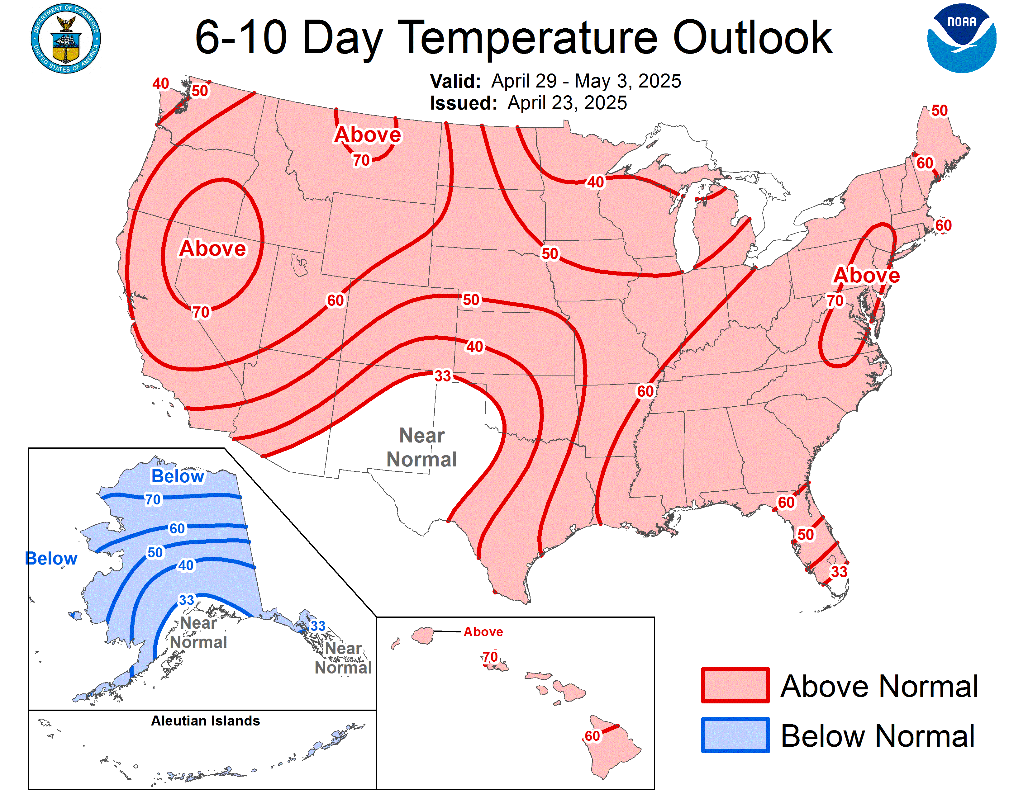
I know the CPC Outlooks are generally dismissed, but it really does seem the 6-10 Day Temperature Outlook reflects the arctic air intrusion into the southern plains, the ridge holding off the se u.s., and areas like oklahoma and north texas being the 'interesting' battle ground between the 2 airmasses.

Image

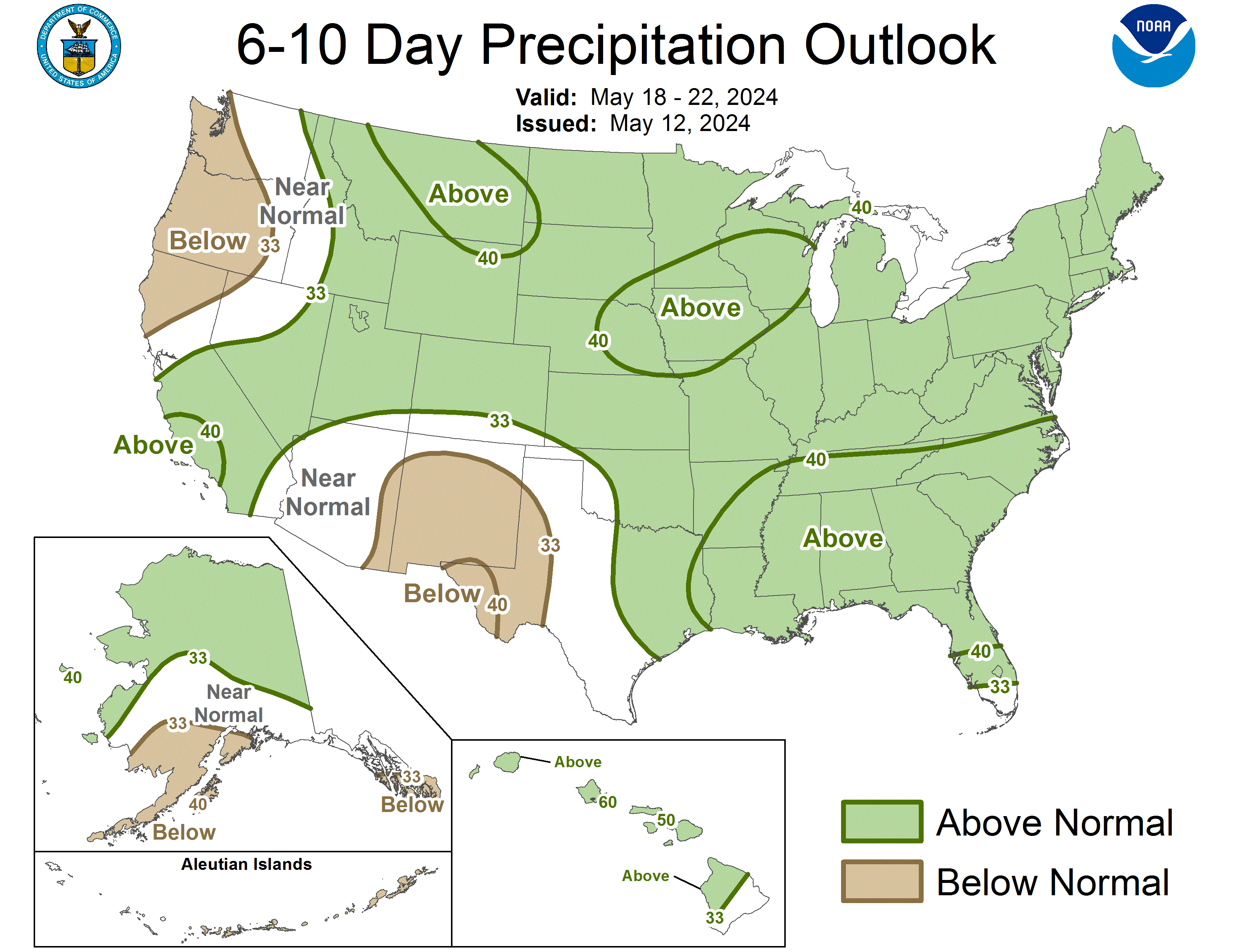
Even the 6-10 Day Precipitation Outlook reiterates how 'interesting' it could be in the battlezone area of the airmasses....i.e., possible below normal temps and above normal precip in Kansas...maybe even into Oklahoma....ding ding ding

Image


iorange55 wrote:The local mets are finally starting to talk about the arctic air next week in Dallas. Saying we'll have to watch the temps closely next week it could get messy.
0 likes   


Return to “Winter Weather”

Who is online

Users browsing this forum: No registered users and 11 guests