2008-09 Texas Winter Weather Thread
Moderator: S2k Moderators
Forum rules
 The posts in this forum are NOT official forecast and should not be used as such. They are just the opinion of the poster and may or may not be backed by sound meteorological data. They are NOT endorsed by any professional institution or STORM2K.

The posts in this forum are NOT official forecast and should not be used as such. They are just the opinion of the poster and may or may not be backed by sound meteorological data. They are NOT endorsed by any professional institution or STORM2K.
-
zaqxsw75050

- Tropical Storm

- Posts: 178
- Joined: Thu Mar 06, 2008 4:21 pm
- Location: Hong Kong
-
vbhoutex

- Storm2k Executive

- Posts: 29146
- Age: 74
- Joined: Wed Oct 09, 2002 11:31 pm
- Location: Cypress, TX
- Contact:
Re:
JenBayles wrote:David - wasn't that the year of the "Christmas Freeze" when people who went out of town came back to flooded homes because their pipes burst? (I'm getting way too old...)
Ed - thanks for the info about how the models work. Much appreciated.
Yes, and we had the same thing in 1983 too. I remember my dad and I up in our attic thawing out the one place we had a frozen pipe(a pipe joint right next to a soffit vent)during that one. We were in a different house for the 1989 freeze and I had the pipes all wrapped long before there was a threat after learning from the first one. I do remember, both times, passing by homes where people were apparently gone and seeing water coming out from under garage doors etc. IIRC there was actually millions in damage from both the 1983 and 1989 freezes.
0 likes
-
JenBayles

- Category 5

- Posts: 3461
- Age: 63
- Joined: Tue Aug 26, 2003 3:27 pm
- Location: Houston, TX
- Contact:
That's right! How could I forget about 1983?! I remember my dad climbing around in the attic with a hair dryer for quite a while early one morning while my mom kvetched non-stop about the lack of water. (Nothing compared to her mouth in Ike's aftermath!) He managed to save the pipes though. The joys of home ownership, huh? Wish I could warm up this morning... 
0 likes
-
TrekkerCC

- S2K Supporter

- Posts: 263
- Joined: Sat Sep 06, 2003 10:19 pm
- Location: North Central Texas (Dallas Area)
Re: 2008-09 Texas Winter Weather Thread
Well, It is currently 27F here after a morning low of 23F. Looks like the cold dome is starting to erode a bit, but we might only get into the 30s to lower 40s tomorrow. Last night we had light sleet and then very light freezing drizzle for awhile, and it was interesting. Today, it appears to be dry, but there are radar echos from the west. NWS Ft. Worth discussion hints that the core of the next arctic shot might go eastward: "THE EXTENDED FORECASTS CONTINUE TO ADVERTISE ANOTHER STRONG FRONT LATE SATURDAY. ALL INDICATIONS ARE THAT THE PATTERN WILL BE FAIRLY PROGRESSIVE WITH A LONGWAVE TROUGH CARRYING THE CORE OF THE ARCTIC AIR EASTWARD." It will be interesting to see how the next arctic intrusion evolves. Even they suggest we might be a big glancing blow with some very cold nights/days over the weekend. It is not over yet by any means.
0 likes
-
Ed Mahmoud
Re: 2008-09 Texas Winter Weather Thread
Source of light potentially freezing precip that could delay school and work Tuesday morning in Houston.
Maybe
Before the magic time, jet streak coming round the trough...

As the magic time approaches, jet streak ejects Northeastward.

Whoo-Hooo, 130 knots

At the magic time, subtle kink in 700 mb heights over Chihuahua, and some relative humidity to boot...

Voila, maybe enough freezing drizzle/light rain to sleep in...

Maybe
Before the magic time, jet streak coming round the trough...
As the magic time approaches, jet streak ejects Northeastward.
Whoo-Hooo, 130 knots
At the magic time, subtle kink in 700 mb heights over Chihuahua, and some relative humidity to boot...
Voila, maybe enough freezing drizzle/light rain to sleep in...
0 likes
-
Ed Mahmoud
Re: 2008-09 Texas Winter Weather Thread
This image makes it a tad more apparent something like a coastal trough will try to set up as well.

0 likes
-
Ed Mahmoud
Re: 2008-09 Texas Winter Weather Thread
Calm winds and slowly rising dewpoints along the I-35 corridor suggest the cold air advection is about over. DFW is still below freezing, and the sun is setting soon. So the icy mist may not quite be done yet.

Now, its wait until next week, and hope more models come around to a kilometer thick layer of cold air and enough sleet to give me an excuse to go in late next week.
Now, its wait until next week, and hope more models come around to a kilometer thick layer of cold air and enough sleet to give me an excuse to go in late next week.
0 likes
-
srainhoutx

- S2K Supporter
- Posts: 6919
- Age: 68
- Joined: Sun Jan 14, 2007 11:34 am
- Location: Haywood County, NC
- Contact:
Re: 2008-09 Texas Winter Weather Thread
HGX has some "interesting" thoughts today....
THE NEXT MAJOR WX CHANGE LOOKS TO OCCUR AS WE HIT THE WINTER
SOLSTICE EARLY SUNDAY MORNING. CONFIDENCE IS BUILDING THAT THIS
WILL BE ANOTHER FAIRLY SHALLOW AND VERY COLD AIR MASS INTRUSION.
ASSUMING THAT THIS IS A NEAR-SFC COLD/DRY AIR MASS...NOTICED THE
TIGHTEST GRADIENT/LOWEST 925-700 MB THICKNESS VALUES (PER ECWMF)
ARE SHUNTED EAST OF THE REGION. THIS WOULD KEEP THE COLDEST AIR
AWAY FROM THE REGION BUT...UPON FURTHER INSPECTION OF THE SFC
PRESSURE BEHAVIOR...THE GFS/EURO SOLUTIONS QUICKLY TAKE THE
BOUNDARY DUE-SOUTHERN TREK TOWARDS THE COAST. LEANING TOWARDS MORE
OF A COLDER CANADIAN PLAINS AIR MASS (OVER SNOW PACK) AND A 1040
MB HIGH DIVING DOWN THE CHUTE. THUS...HAVE DECREASED TDS QUITE
QUICKLY AND ONLY BROUGHT SUNDAY`S MAXIMUMS UP INTO THE LOWER 40S
FOR MANY FAR INTERIOR REGIONS IN THE IMMEDIATE WAKE OF THIS
AGGRESSIVE FROPA. AS OF NOW...IT LOOKS AS IF BEST MOISTURE IS OUT-
OF-PHASE WITH THE COLDEST AIR SO HAVE LEFT ANY WINTRY MIX OUT OF
THE FORECAST. ANY WINTRY THREAT WOULD BE SIMILAR TO A COUPLE OF
DAYS AGO...WHEN FREEZING RAIN WAS CAUSING HAZARDOUS DRIVING
CONDITIONS ACROSS THE FAR NORTHERN CWA REACHES. IN ACCOUNTING FOR
LINGERING CLOUD COVER ON MONDAY...HAVE KEPT DAILY HIGHS ON THE
COOL SIDE OF 50F...WARMING BACK UP INTO THE UPPER 50S TUESDAY.
THE NEXT COLD FRONT IS TIMED FOR WEDNESDAY MORNING AND IS CURRENTLY
NOT PACKING QUITE THE COLD AIR PUNCH IN RELATION TO WHAT IS BEHIND
SUNDAY`S FROPA. AS THIS FORECAST ENDS ON CHRISTMAS EVE DAY...WILL
HAPPILY DEFER TO FUTURE SHIFTS ON WHETHER OR NOT WE WILL BE ON THE
WINTER SIDE OF THIS ONGOING TWO-DAY SEASONAL FLIP FLOP PATTERN OF
LATE. 31
Amarillo offered this little "nugget" concerning the Christmas Eve front...snipet...
SECOND...AND POSSIBLY COLDER FRONT...IS THEN PROGGED TO BLOW
THROUGH THE PANHANDLES ON WEDNESDAY. GFS SUGGESTS 850MB TEMPS WILL
FALL INTO THE -14 TO -16 DEGREES C RANGE...AND EVEN PUSH THE FRONT
CLEAR TO THE YUCATAN PENINSULA. THIS PUTS THE FORECAST INTO THE DAY
8 RANGE...SO DID NOT GET TOO CRAZY ON TEMPS LATE NEXT WEEK. BUT THIS
WILL CERTAINLY BE A FRONT TO WATCH FOR COLD AIR.
0 likes
Re: 2008-09 Texas Winter Weather Thread
CPC Outlook through 1st day of 2009!!! Trending slightly warmer than yesterday. Maps and Discussion excerpts follow below.

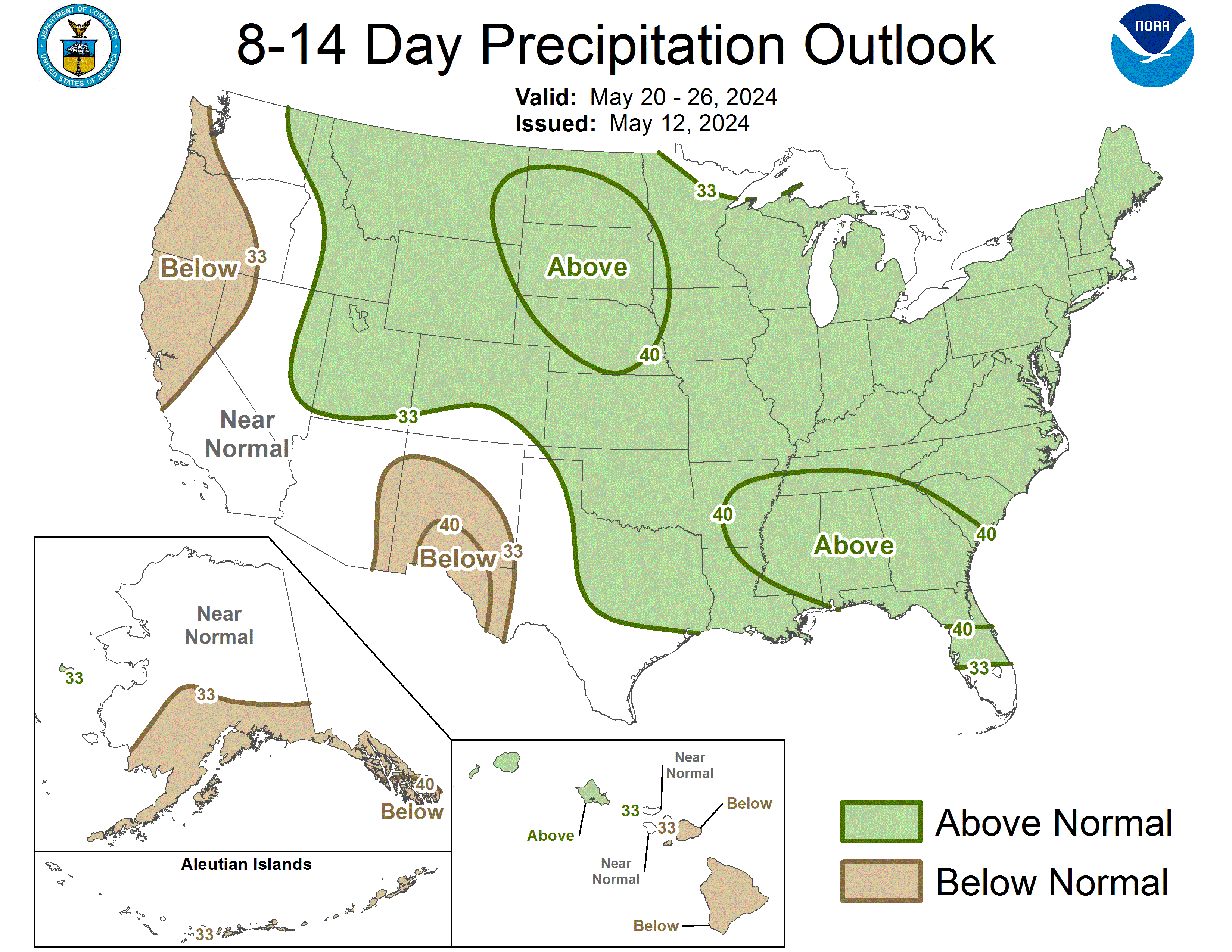
NWS CLIMATE PREDICTION CENTER CAMP SPRINGS, MD
300 PM EST THU DEC 18 2008
TODAYS ENSEMBLE MEAN SOLUTIONS REMAIN IN GOOD AGREEMENT ON THE EXPECTED 500-HPA
HEIGHT PATTERN IN DEPICTING THE STRONG RIDGE BETWEEN HAWAII AND ALASKA, A
HIGHLY AMPLIFIED AND POSITIVELY TILTED TROUGH ACROSS THE WESTERN CONUS,
THE RIDGE OVER THE SOUTH, AND THE RIDGE OVER UK. TELECONNECTIONS OFF OF THE STRONG
POSITIVE ANOMALIES IN THE PACIFIC AND THE UK AREA ARE CONSISTENT WITH THE
TROUGH OVER THE WEST AND THE WEAK RIDGING OVER THE SOUTH. THIS GIVES MORE
CONFIDENCE IN THE MODEL RESULTS, WHICH AGAIN TODAY ARE QUITE SIMILAR.
THE MAIN DIFFERENCE FROM YESTERDAY IS THE SLIGHT INCREASE IN WARMTH SHOWN IN THE VARIOUS
FORECAST TOOLS. WITH THE COLD HIGH PRESSURE SYSTEM THAT HAD BEEN CONTRIBUTING
TO THE VERY LOW TEMPERATURES FORECAST FOR THE PLAINS AND MIDWEST EXITING THE
EAST COAST AT THE START OF THIS FORECAST PERIOD ON CHRISTMAS EVE, IT IS
REASONABLE TO SHRINK THE AREA OF FORECAST ANOMALOUS COLD.
ALSO, THE MEAN 500-HPA HEIGHT FORECAST AS WELL AS THE INDIVIDUAL DAILY FORECASTS DO SHOW SOME
EXPANSION NORTHWARD AND WESTWARD OF THE SOUTHERN HIGH PRESSURE SYSTEM. SIMILAR
TO THE PREVIOUS FORECASTS THIS WEEK, THE FORECAST TOOLS SHOWING THE LEAST
AMOUNT OF WARMTH FOR THE NORTHERN HALF OF THE CONUS ARE FAVORED. ABOVE-NORMAL
SNOW COVER SHOULD KEEP TEMPERATURES LOWER THAN MANY OF THE USUAL FORECASTS
INDICATE. THE PRECIPITATION PATTERN IS LITTLE CHANGED FROM THE FORECASTS MADE
EARLIER THIS WEEK, WITH THE ACTIVE STORM TRACK CONTINUING ACROSS THE COUNTRY.
FOR WEEK 2, MODEL SOLUTIONS REMAIN IN GOOD AGREEMENT ON THE OVERALL LARGE-SCALE
PATTERN, WHICH IS SIMILAR TO THE 6-10 DAY PATTERN, WITH THE LARGE TROUGH
CONTINUING TO DOMINATE THE WEST. THE EXPECTED STORM TRACK SHOULD CONTINUE TO
BRING ABOVE-NORMAL RAIN OR SNOW TO MUCH OF THE WEST AND THE EAST.
FORECAST CONFIDENCE FOR THE 8-14 DAY PERIOD IS: ABOVE AVERAGE, 4 ON A SCALE OF
1 TO 5, DUE TO GOOD MODEL AGREEMENT.
0 likes
-
cctxhurricanewatcher

- Category 5
- Posts: 1206
- Joined: Sun Sep 12, 2004 8:53 pm
- Location: Corpus Christi, Texas
Re: 2008-09 Texas Winter Weather Thread
jinftl wrote:CPC Outlook through 1st day of 2009!!! Trending slightly warmer than yesterday. Maps and Discussion excerpts follow below.
NWS CLIMATE PREDICTION CENTER CAMP SPRINGS, MD
300 PM EST THU DEC 18 2008
TODAYS ENSEMBLE MEAN SOLUTIONS REMAIN IN GOOD AGREEMENT ON THE EXPECTED 500-HPA
HEIGHT PATTERN IN DEPICTING THE STRONG RIDGE BETWEEN HAWAII AND ALASKA, A
HIGHLY AMPLIFIED AND POSITIVELY TILTED TROUGH ACROSS THE WESTERN CONUS,
THE RIDGE OVER THE SOUTH, AND THE RIDGE OVER UK. TELECONNECTIONS OFF OF THE STRONG
POSITIVE ANOMALIES IN THE PACIFIC AND THE UK AREA ARE CONSISTENT WITH THE
TROUGH OVER THE WEST AND THE WEAK RIDGING OVER THE SOUTH. THIS GIVES MORE
CONFIDENCE IN THE MODEL RESULTS, WHICH AGAIN TODAY ARE QUITE SIMILAR.
THE MAIN DIFFERENCE FROM YESTERDAY IS THE SLIGHT INCREASE IN WARMTH SHOWN IN THE VARIOUS
FORECAST TOOLS. WITH THE COLD HIGH PRESSURE SYSTEM THAT HAD BEEN CONTRIBUTING
TO THE VERY LOW TEMPERATURES FORECAST FOR THE PLAINS AND MIDWEST EXITING THE
EAST COAST AT THE START OF THIS FORECAST PERIOD ON CHRISTMAS EVE, IT IS
REASONABLE TO SHRINK THE AREA OF FORECAST ANOMALOUS COLD.
ALSO, THE MEAN 500-HPA HEIGHT FORECAST AS WELL AS THE INDIVIDUAL DAILY FORECASTS DO SHOW SOME
EXPANSION NORTHWARD AND WESTWARD OF THE SOUTHERN HIGH PRESSURE SYSTEM. SIMILAR
TO THE PREVIOUS FORECASTS THIS WEEK, THE FORECAST TOOLS SHOWING THE LEAST
AMOUNT OF WARMTH FOR THE NORTHERN HALF OF THE CONUS ARE FAVORED. ABOVE-NORMAL
SNOW COVER SHOULD KEEP TEMPERATURES LOWER THAN MANY OF THE USUAL FORECASTS
INDICATE. THE PRECIPITATION PATTERN IS LITTLE CHANGED FROM THE FORECASTS MADE
EARLIER THIS WEEK, WITH THE ACTIVE STORM TRACK CONTINUING ACROSS THE COUNTRY.
FOR WEEK 2, MODEL SOLUTIONS REMAIN IN GOOD AGREEMENT ON THE OVERALL LARGE-SCALE
PATTERN, WHICH IS SIMILAR TO THE 6-10 DAY PATTERN, WITH THE LARGE TROUGH
CONTINUING TO DOMINATE THE WEST. THE EXPECTED STORM TRACK SHOULD CONTINUE TO
BRING ABOVE-NORMAL RAIN OR SNOW TO MUCH OF THE WEST AND THE EAST.
FORECAST CONFIDENCE FOR THE 8-14 DAY PERIOD IS: ABOVE AVERAGE, 4 ON A SCALE OF
1 TO 5, DUE TO GOOD MODEL AGREEMENT.
They had us above normal for this week a few weeks ago. Ain't going to happen.
0 likes
-
Portastorm

- Storm2k Moderator

- Posts: 9954
- Age: 63
- Joined: Fri Jul 11, 2003 9:16 am
- Location: Round Rock, TX
- Contact:
Re: 2008-09 Texas Winter Weather Thread
Yeah CC, those CPC outlooks are pretty much useless. One is much better off looking at the GFS and Euro ensembles and getting a sense of what they suggest. I've also read some posts here and on other boards from pro mets who dismiss the CPC outlooks as lightweight at best.
0 likes
-
CaptinCrunch

- S2K Supporter
- Posts: 8777
- Age: 58
- Joined: Mon Nov 03, 2003 4:33 pm
- Location: Kennedale, TX (Tarrant Co.)
Re: 2008-09 Texas Winter Weather Thread
Not a paid employee of the CPC or any vested interest like that...and will be more than happy to label the outlooks as garbage...but they nailed the warmth and ridge over florida now when many were using GFS runs to call for a Dec 1989 repeat...and called for the trough and winter precip over the southwest more than a week ago.
If NWS Houston forecast verifies...Houston is about 5 deg above normal for the period today through christmas...as the CPC Oulook 10 days ago showed for this same period...it all comes down to what 'averages out'....a cold day or 2 doesn't mean a period won't be above normal...http://forecast.weather.gov/MapClick.php?site=hgx&map.x=212&map.y=152
CPC uses same models you mention...additional excerpts from today's discussion (ready and willing to label this all as garbage...and curious to learn what those who dismiss CPC outlooks look to for unbiased guidance):
TODAYS OFFICIAL 500-HPA BLEND CONSISTS OF 60 PERCENT OF TODAY'S GFS
SUPERENSEMBLE MEAN CENTERED ON DAY 8...AND 40 PERCENT OF TODAY'S EUROPEAN
ENSEMBLE MEAN CENTERED ON DAY 7.
TEMPERATURE PROG IS BASED ON THE THE KLEIN SPECIFICATIONS FROM THE
MANUAL 500-HPA BLEND AND THE NORTH AMERICAN ENSEMBLE FORECAST SYSTEM (NAEFS).
PRECIPITATION PROG IS BASED ON THE NAEFS PRECIPITATION TOOL, THE GFS ENSEMBLE, AND DAILY FORECASTS FROM THE RECENT OPERATIONAL EC AND GFS RUNS.
FOR WEEK 2, MODEL SOLUTIONS REMAIN IN GOOD AGREEMENT ON THE OVERALL LARGE-SCALE
PATTERN, WHICH IS SIMILAR TO THE 6-10 DAY PATTERN, WITH THE LARGE TROUGH
CONTINUING TO DOMINATE THE WEST. THE EXPECTED STORM TRACK SHOULD CONTINUE TO
BRING ABOVE-NORMAL RAIN OR SNOW TO MUCH OF THE WEST AND THE EAST.
Portastorm wrote:Yeah CC, those CPC outlooks are pretty much useless. One is much better off looking at the GFS and Euro ensembles and getting a sense of what they suggest. I've also read some posts here and on other boards from pro mets who dismiss the CPC outlooks as lightweight at best.
0 likes
-
Portastorm
- Storm2k Moderator
- Posts: 9954
- Age: 63
- Joined: Fri Jul 11, 2003 9:16 am
- Location: Round Rock, TX
- Contact:
Re: 2008-09 Texas Winter Weather Thread
To be fair, I am not aware of any professional meteorologist outside of Accuweather's Joe Bastardi who was referencing December 1989 about this week. The rest of the "chatter" came from weather weenies on our board and others. And I also recall plenty of cynics too who poo-poo'ed the idea of pipe-busting cold so it wasn't an entire congregation saying "amen" if you know what I mean.
I just wouldn't get too attached to those CPC outlooks, jinftl. I feel one is much better informed by examining the ensembles.
I just wouldn't get too attached to those CPC outlooks, jinftl. I feel one is much better informed by examining the ensembles.
0 likes
Re: 2008-09 Texas Winter Weather Thread
Fair enough...i think your approach would lead to the most accurate results in the long run. Along the same lines, the CPC Outlooks are dismissed way too quickly...even with the analysis using the same models people chat about here. I know there is always the 'agree if you like the forecast, disagree if you don't' factor to contend with, but...at the very least...i like the discussions they provide because often it is hard for a pure amateur like me to know how to read a map of a model run and infer a forecast from it. It is also interesting to see that the pros do struggle with conflicting data, models, etc...something they have no problem mentioning in the daily discussion they provide...and from those incongrous pieces, they put a forecast out there.
But I am 100% open to additional, alternate sources that provide not only a graphical outlook, but even more...the discussion behind it.
But I am 100% open to additional, alternate sources that provide not only a graphical outlook, but even more...the discussion behind it.
Portastorm wrote:To be fair, I am not aware of any professional meteorologist outside of Accuweather's Joe Bastardi who was referencing December 1989 about this week. The rest of the "chatter" came from weather weenies on our board and others. And I also recall plenty of cynics too who poo-poo'ed the idea of pipe-busting cold so it wasn't an entire congregation saying "amen" if you know what I mean.
I just wouldn't get too attached to those CPC outlooks, jinftl. I feel one is much better informed by examining the ensembles.
0 likes
-
Ed Mahmoud
Re: 2008-09 Texas Winter Weather Thread
Note manly packing of isobars and 510 dm thickness line diving through Minnesota per NAM. Note also the front at 850 mb seems to hang up just South of Houston even as the surface high pushes out into the Gulf.
NAM Central US 84 hour loop
The surface pressures indicate flow barely has any component of North to it at all at 84 hours, and no precip has started yet, so I still don't see any work delaying weather, but it is reassuring to know decent humidity is only a few (dozen) miles away.
I know it is a shallow air mass, and its the NAM, but the 850 mb freezing line never clears the area, so maybe we'll avoid too harsh of a freeze.
0 likes
-
jasons2k

- Storm2k Executive
- Posts: 8290
- Age: 52
- Joined: Wed Jul 06, 2005 12:32 pm
- Location: The Woodlands, TX
Re: 2008-09 Texas Winter Weather Thread
Portastorm wrote:To be fair, I am not aware of any professional meteorologist outside of Accuweather's Joe Bastardi who was referencing December 1989 about this week. The rest of the "chatter" came from weather weenies on our board and others. And I also recall plenty of cynics too who poo-poo'ed the idea of pipe-busting cold so it wasn't an entire congregation saying "amen" if you know what I mean.
I just wouldn't get too attached to those CPC outlooks, jinftl. I feel one is much better informed by examining the ensembles.
To be accurate (and sometimes accuracy isn't always "fair"), back around December 4th, there was more than one pro met out there floating the idea of a 1989 or 1983 type event for mid-December. And of course, the usual suspects jumped on the bandwagon confidently declaring 'don't worry, the cold will come' and the usual skeptics saying 'not so fast, we've heard this before.'
But to be fair, it happens every year. And so far, the skeptics have been right every single time
0 likes
-
Portastorm
- Storm2k Moderator
- Posts: 9954
- Age: 63
- Joined: Fri Jul 11, 2003 9:16 am
- Location: Round Rock, TX
- Contact:
Re: 2008-09 Texas Winter Weather Thread
Dang it, Jason ... why are you always messing my arguments up with facts and stuff like that?! 
You ... you ... you Mike Leach lover you!
You ... you ... you Mike Leach lover you!
0 likes
-
jasons2k
- Storm2k Executive
- Posts: 8290
- Age: 52
- Joined: Wed Jul 06, 2005 12:32 pm
- Location: The Woodlands, TX
Re: 2008-09 Texas Winter Weather Thread
Go Tech!
What's ironic is that I'm wearing a Texas Longhorns T-shirt today. Yes, I lost a bet a few years ago and had to wear a UT t-shirt to work one day. I kept the T-shirt for yardwork days, etc.
0 likes
Who is online
Users browsing this forum: No registered users and 61 guests