
NW Australia: BILLY - Tropical Cyclone: Discussion
Moderator: S2k Moderators
-
HURAKAN

- Professional-Met

- Posts: 46084
- Age: 39
- Joined: Thu May 20, 2004 4:34 pm
- Location: Key West, FL
- Contact:
TROPICAL CYCLONE TECHNICAL BULLETIN: AUSTRALIA - WESTERN REGION
Issued by PERTH TROPICAL CYCLONE WARNING CENTRE
at: 1259 UTC 27/12/2008
Name: Billy
Data At: 1200 UTC
Latitude: 15.3S
Longitude: 112.9E
Location Accuracy: within 20 nm [37 km]
Movement Towards: west [270 deg]
Speed of Movement: 2 knots [3 km/h]
Maximum 10-Minute Wind: 45 knots [85 km/h]
Maximum 3-Second Wind Gust: 65 knots [120 km/h]
Central Pressure: 983 hPa
Radius of 34-knot winds NE quadrant: 45 nm [85 km]
Radius of 34-knot winds SE quadrant: 30 nm [55 km]
Radius of 34-knot winds SW quadrant: 80 nm [150 km]
Radius of 34-knot winds NW quadrant: 80 nm [150 km]
Radius of 48-knot winds NE quadrant:
Radius of 48-knot winds SE quadrant:
Radius of 48-knot winds SW quadrant:
Radius of 48-knot winds NW quadrant:
Radius of 64-knot winds:
Radius of Maximum Winds: 25 nm [46 km]
Dvorak Intensity Code: T3.0/3.0/W1.0/24HRS
Pressure of outermost isobar: 998 hPa
Radius of outermost closed isobar: 80 nm [150 km]
Storm Depth: Deep
FORECAST DATA
Date/Time : Location : Loc. Accuracy: Max Wind : Central Pressure
[UTC] : degrees : nm [km]: knots[km/h]: hPa
+12: 28/0000: 15.6S 112.2E: 050 [095]: 045 [085]: 984
+24: 28/1200: 16.2S 111.5E: 080 [150]: 040 [075]: 987
+36: 29/0000: 16.5S 110.1E: 110 [210]: 035 [065]: 990
+48: 29/1200: 17.2S 109.0E: 145 [270]: 030 [055]: 993
+60: 30/0000: 17.4S 107.3E: 190 [355]: 030 [055]: 993
+72: 30/1200: 17.8S 105.8E: 240 [445]: 025 [045]: 995
REMARKS:
Billy is now moving slowly westwards and is expected to develop a more southwest
track overnight now that a mid level trough - evident in water vapour imagery
and well modelled by NWP - has eroded the ridge to the south.
Persisting moderate NE shear of 20-25 knots continues to weaken the system with
deep convection confined to western quadrants about a low level circulation
centre that is gradually becoming less well defined. Dvorak based on shear
pattern with LLCC within 0.5degree of deep convection. DT/MET/FT/CI=3.0.
Further weakening is forecast under the shear and cooler sea temperatures
especially as it nears 110E. Models indicate upper winds may become more
favourable in the next 12 hours which may slow the weakening trend.
==
The next bulletin for this system will be issued by: 27/1900 UTC by Perth TCWC.
0 likes


Barely holding on as a TC.
AXAU01 APRF 280126
IDW27600
TROPICAL CYCLONE TECHNICAL BULLETIN: AUSTRALIA - WESTERN REGION
Issued by PERTH TROPICAL CYCLONE WARNING CENTRE
at: 0126 UTC 28/12/2008
Name: Billy
Data At: 0000 UTC
Latitude: 15.0S
Longitude: 112.8E
Location Accuracy: within 20 nm [37 km]
Movement Towards: near stationary
Speed of Movement: near stationary
Maximum 10-Minute Wind: 35 knots [65 km/h]
Maximum 3-Second Wind Gust: 50 knots [95 km/h]
Central Pressure: 990 hPa
Radius of 34-knot winds NE quadrant: 50 nm [95 km]
Radius of 34-knot winds SE quadrant: 40 nm [75 km]
Radius of 34-knot winds SW quadrant: 80 nm [150 km]
Radius of 34-knot winds NW quadrant: 80 nm [150 km]
Radius of 48-knot winds NE quadrant:
Radius of 48-knot winds SE quadrant:
Radius of 48-knot winds SW quadrant:
Radius of 48-knot winds NW quadrant:
Radius of 64-knot winds:
Radius of Maximum Winds: 40 nm [75 km]
Dvorak Intensity Code: T2.0/3.0/W1.0/24HRS
Pressure of outermost isobar: 1000 hPa
Radius of outermost closed isobar: 110 nm [205 km]
Storm Depth: Medium
FORECAST DATA
Date/Time : Location : Loc. Accuracy: Max Wind : Central Pressure
[UTC] : degrees : nm [km]: knots[km/h]: hPa
+12: 28/1200: 15.4S 112.1E: 050 [095]: 030 [055]: 994
+24: 29/0000: 15.5S 110.7E: 080 [150]: 030 [055]: 995
+36: 29/1200: 15.8S 109.6E: 110 [210]: 030 [055]: 994
+48: 30/0000: 15.7S 108.4E: 145 [270]: 030 [055]: 995
+60: 30/1200: 16.1S 107.4E: 190 [355]: 025 [045]: 997
+72: 31/0000: 16.0S 105.9E: 240 [445]: 025 [045]: 998
REMARKS:
Billy has continued to weaken over previous 24 hours with an exposed centre and
enlarged defined circulation.Convection has re-emerged to the northwest of the
centre overnight and marginal gales remain possible.
Dvorak shear pattern gives DT/FT=2.0, but CI held at 3.0 with discretion.
With a well defined surface circulation and convection possibly pulsing
periodically with diurnal forcing, the system may produce near gales for next 48
hours. However, with convection likely to ease through the afternoon it will be
difficult to sustain tropical cyclone intensity as forecast.
Billy has moved only slowly in last 12 hours under weak steering environment but
a new ridge building to the south should push the circulation to the west or
west southwest in the forecast period.
==
The next bulletin for this system will be issued by: 28/0700 UTC by Perth TCWC.
0 likes
-
HURAKAN
- Professional-Met
- Posts: 46084
- Age: 39
- Joined: Thu May 20, 2004 4:34 pm
- Location: Key West, FL
- Contact:
Re: NW Australia: BILLY - Tropical Cyclone: Discussion
TROPICAL CYCLONE TECHNICAL BULLETIN: AUSTRALIA - WESTERN REGION
Issued by PERTH TROPICAL CYCLONE WARNING CENTRE
at: 1224 UTC 28/12/2008
Name: Billy
Data At: 1200 UTC
Latitude: 16.0S
Longitude: 112.5E
Location Accuracy: within 15 nm [28 km]
Movement Towards: southwest [230 deg]
Speed of Movement: 6 knots [12 km/h]
Maximum 10-Minute Wind: 30 knots [55 km/h]
Maximum 3-Second Wind Gust: 45 knots [85 km/h]
Central Pressure: 995 hPa
Radius of 34-knot winds NE quadrant:
Radius of 34-knot winds SE quadrant:
Radius of 34-knot winds SW quadrant:
Radius of 34-knot winds NW quadrant:
Radius of 48-knot winds NE quadrant:
Radius of 48-knot winds SE quadrant:
Radius of 48-knot winds SW quadrant:
Radius of 48-knot winds NW quadrant:
Radius of 64-knot winds:
Radius of Maximum Winds: N/A
Dvorak Intensity Code: T2.0/2.5/W1.5/24HRS
Pressure of outermost isobar: 1000 hPa
Radius of outermost closed isobar: 110 nm [205 km]
Storm Depth: Medium
FORECAST DATA
Date/Time : Location : Loc. Accuracy: Max Wind : Central Pressure
[UTC] : degrees : nm [km]: knots[km/h]: hPa
+12: 29/0000: 16.2S 111.1E: 045 [085]: 030 [055]: 995
+24: 29/1200: 16.5S 110.1E: 075 [140]: 025 [045]: 997
+36: 30/0000: 16.5S 108.7E: 110 [200]: 025 [045]: 997
+48: 30/1200: 17.0S 107.9E: 140 [260]: 025 [045]: 997
+60: 31/0000: 17.0S 106.1E: 190 [345]: 020 [035]: 1000
+72: 31/1200: 17.1S 104.8E: 235 [435]: 020 [035]: 1000
REMARKS:
Ex-Billy is now clearly below TC intensity. Renmnant cloud is becoming
increasingly stratiform, only small amounts of convection are being intiated by
the remaining low level convergence and the cloud pattern to the west of the
system indicates a stable airmass along the forecast track.
The remnant system is forecast to move steadily west under the influence of the
high pressure system to the south.
==
There will be no further bulletins for this system.
0 likes
-
wyq614

- Category 3

- Posts: 827
- Age: 37
- Joined: Sun Dec 02, 2007 12:32 am
- Location: Beijing, China (Hometown: Qingdao, China, 36.06N 120.43E)
- Contact:
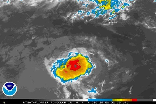
Some restrengthening is observed by SSD
WWIO21 KNES 290908
A. 05S (BILLY)
B. 29/0830Z
C. 16.9S
D. 110.4E
E. FIVE/MTSAT
F. T2.5/2.5/D1.0/24HRS
G. IR/EIR/VIS
H. REMARKS...CONVECTION HAS CONTINUED TO DEVELOP INTO A LARGE COLD
CLUSTER BUT ALSO WITH A BANDING SHAPE PARTICULARLY IN VIS. LLC MAYBE
TRYING TO REDEVELOP MUCH CLOSER TO THE LLC...AND LACK OF MI MAKES
CONFIDENCE OF LLC VERY LOW. BEST GUESS LLC IS ABOUT .8 DEGREES FROM
DEEP CONVECTION AND BANDING YEILDS .4 BOTH INDICATIVE OF DT 2.5. MET IS
2.5. PT 2.5. THOUGH PARAMETERS FOR 2.5 WERE BARELY MET FT OF 2.5 BASED
ON DT...THOUGH SYSTEM IS ON WEAKER SIDE OF 2.5...GALLINA
I. ADDL POSITIONS
NIL
0 likes


-
Squarethecircle
- Category 5

- Posts: 2165
- Joined: Fri Oct 19, 2007 4:00 pm
- Location: Fairfax, VA
-
HURAKAN
- Professional-Met
- Posts: 46084
- Age: 39
- Joined: Thu May 20, 2004 4:34 pm
- Location: Key West, FL
- Contact:
Re:
Squarethecircle wrote::uarrow: How the heck is it back?
Back to a disturbance. Floater still available. Link: http://www.ssd.noaa.gov/PS/TROP/mtsatfloat2.html
0 likes
-
Squarethecircle
- Category 5
- Posts: 2165
- Joined: Fri Oct 19, 2007 4:00 pm
- Location: Fairfax, VA
Re: Re:
HURAKAN wrote:Squarethecircle wrote::uarrow: How the heck is it back?
Back to a disturbance. Floater still available. Link: http://www.ssd.noaa.gov/PS/TROP/mtsatfloat2.html
No, as in, "How did that happen?"
0 likes
Who is online
Users browsing this forum: No registered users and 32 guests