The 12Z run brings in a possible snow storm for the East Coast on the 8th - a day earlier than the 6z run links that I have above;
http://www.nco.ncep.noaa.gov/pmb/nwprod ... _252.shtml
http://www.nco.ncep.noaa.gov/pmb/nwprod ... _264.shtml
Southern Plains winter wx thread (2008-2009)
Moderator: S2k Moderators
Forum rules
 The posts in this forum are NOT official forecast and should not be used as such. They are just the opinion of the poster and may or may not be backed by sound meteorological data. They are NOT endorsed by any professional institution or STORM2K.

The posts in this forum are NOT official forecast and should not be used as such. They are just the opinion of the poster and may or may not be backed by sound meteorological data. They are NOT endorsed by any professional institution or STORM2K.
-
Portastorm

- Storm2k Moderator

- Posts: 9954
- Age: 63
- Joined: Fri Jul 11, 2003 9:16 am
- Location: Round Rock, TX
- Contact:
Re: Another round of frigid air to arrive in early January?
I definitely concur jinftl. I don't expect much change in the next 7-10 days. Looks like mostly a zonal flow in Southtown USA and mainly seasonal temps. The modeling beyond 10 days is of interest but we all know to take it with a grain of salt. Many of the pro mets who predicted a very cold December and a blow torch in January are now suggesting that January may not be so warm. Whatever signals the atmosphere is giving, my sense is they are complicated enough that no one really has a good lock on what will happen beyond Day 7.
I asked Santa for just one snow/sleet, work/school-canceling event here in Austin followed by springtime weather.
I asked Santa for just one snow/sleet, work/school-canceling event here in Austin followed by springtime weather.
0 likes
Re: Another round of frigid air to arrive in early January?
That doesn't seem an unreasonable request to Santa at all....Texas has been an 'interesting' battleground state in December....in terms of quick transitions from very cold to very warm and back again. Get some precip at the right time during one of these transitions...and a snow day may very well happen...just take pics because it may not stick around long!
On a side note, your post reminds me of my senior year in high school in the boston area...seniors graduated on a 'set date' so we wouldn't have to 'make up' any snow days at the end of the year. Of course that winter featured little snow, and what did fall, fell on the weekends! No snow days!
On a side note, your post reminds me of my senior year in high school in the boston area...seniors graduated on a 'set date' so we wouldn't have to 'make up' any snow days at the end of the year. Of course that winter featured little snow, and what did fall, fell on the weekends! No snow days!
Portastorm wrote:
I asked Santa for just one snow/sleet, work/school-canceling event here in Austin followed by springtime weather.
0 likes
-
Stephanie

- S2K Supporter

- Posts: 23843
- Age: 63
- Joined: Thu Feb 06, 2003 9:53 am
- Location: Glassboro, NJ
Re: Another round of frigid air to arrive in early January?
Portastorm wrote:The modeling beyond 10 days is of interest but we all know to take it with a grain of salt.
Most definitely.
0 likes
Re: Another round of frigid air to arrive in early January?
Amazing shrinking snowpack....image on top is from 12/24/08....image below is from 12/28/08. The snowpack from 4 days ago essentially is gone over the Central Plains...across Indiana and Ohio....into parts of New York state and Southern New England.


0 likes
-
Portastorm
- Storm2k Moderator
- Posts: 9954
- Age: 63
- Joined: Fri Jul 11, 2003 9:16 am
- Location: Round Rock, TX
- Contact:
Re: Another round of frigid air to arrive in early January?
Everyone must still be in *vacation mode* because I cannot believe no one has posted yet on today's 12z GFS which I will subtitle "Old Man Winter Visits the Southern Plains and Texas." 
Pretty much starting at 144 hours (Sunday), we get some good Canadian air in place followed by several more and stronger blasts of Canadian/Arctic air ... and there are some disturbances at the lower levels that may offer ice and snow for some (or a lot) of us. Gotta admit now that the GFS has consistently shown (several days) a pattern change starting late this coming weekend and I'm buying into it. (Portastorm making sure he knows where his kicking shoes are located).
BTW, where's our man EWG?? He must be away from his computer for awhile. I'm sure he'd be posting by now!
Here's a link to the 12z GFS 4-panel charts:
http://www.nco.ncep.noaa.gov/pmb/nwprod/analysis/namer/gfs/12/fpc.shtml
0 likes
-
wxman22

- Category 5

- Posts: 1849
- Joined: Mon Jan 30, 2006 12:39 am
- Location: Wichita Falls, TX
- Contact:
Re: Another round of frigid air to arrive in early January?
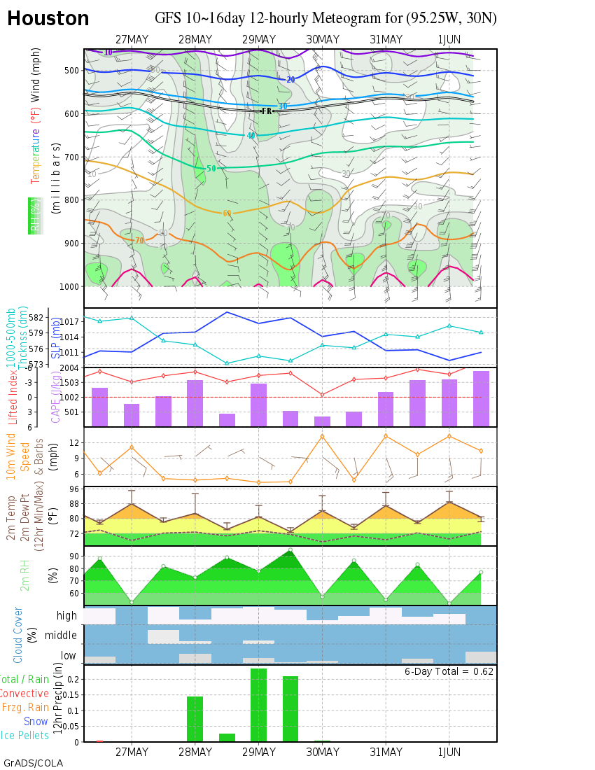
Heres the meteogram charts of the 12z GFS Houston snow? http://wxmaps.org/pix/iahgfsb.png
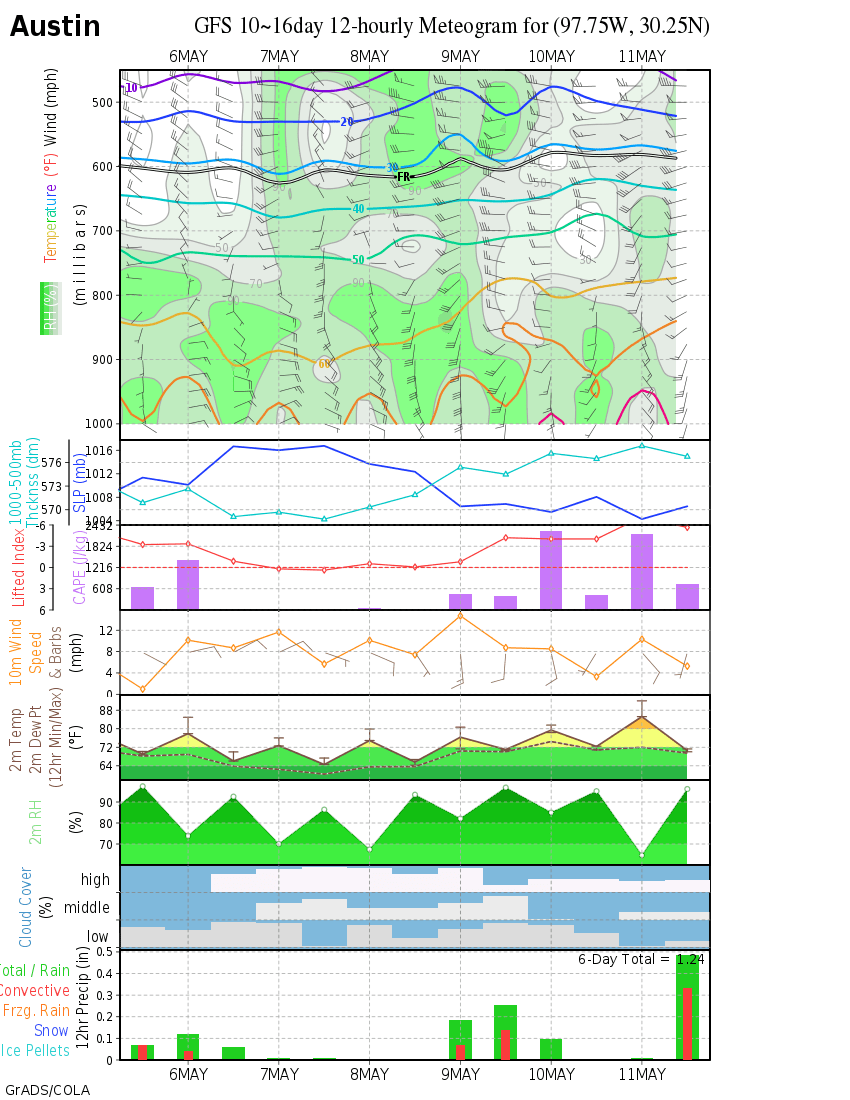
Austin snow? http://wxmaps.org/pix/ausgfsb.png
Will have to see ofcourse its in lala land but its a little hard to ignore when the GFS has been consistent on showing this weather setup around the 2nd week of Janurary...
Austin snow? http://wxmaps.org/pix/ausgfsb.png
Will have to see ofcourse its in lala land but its a little hard to ignore when the GFS has been consistent on showing this weather setup around the 2nd week of Janurary...
0 likes
-
cctxhurricanewatcher

- Category 5
- Posts: 1206
- Joined: Sun Sep 12, 2004 8:53 pm
- Location: Corpus Christi, Texas
Re: Another round of frigid air to arrive in early January?
Portastorm wrote:Everyone must still be in *vacation mode* because I cannot believe no one has posted yet on today's 12z GFS which I will subtitle "Old Man Winter Visits the Southern Plains and Texas."
Pretty much starting at 144 hours (Sunday), we get some good Canadian air in place followed by several more and stronger blasts of Canadian/Arctic air ... and there are some disturbances at the lower levels that may offer ice and snow for some (or a lot) of us. Gotta admit now that the GFS has consistently shown (several days) a pattern change starting late this coming weekend and I'm buying into it. (Portastorm making sure he knows where his kicking shoes are located).
BTW, where's our man EWG?? He must be away from his computer for awhile. I'm sure he'd be posting by now!
Here's a link to the 12z GFS 4-panel charts:
http://www.nco.ncep.noaa.gov/pmb/nwprod/analysis/namer/gfs/12/fpc.shtml
I think some of us are on the "Winter Cancel" bandwagon for the time being. It was downright depressing watching football all over the country weekend before last and in almost every stadium with the exception of Miami, the games were being playing in winter time conditions. Meanwhile here in south Texas, I put my kids swing set together in 90 degree weather Saturday and "enjoyed" shorts on Christmas day with an idle fireplace.
Unitl the GFS ( the Dallas Cowboy weather model) verfies one of these scenerios, it's just another overhyped tool.
BUT, NWS Amarillo did issue a "Bear Watch" for the pattern beyond next week if that helps.
0 likes

Re: Another round of frigid air to arrive in early January?
I think people are still watching the models and coming on here. I think they just don't want to post anything yet, because well we have kind of been let down by the models so far. Although that doesn't really seem like a new thing.
0 likes
-
Portastorm
- Storm2k Moderator
- Posts: 9954
- Age: 63
- Joined: Fri Jul 11, 2003 9:16 am
- Location: Round Rock, TX
- Contact:
Re: Another round of frigid air to arrive in early January?
Being a native Clevelander sports fan, being "let down" or disappointed is my birthright so I'm used to that! 
The 12z Euro is looking pretty good for some cold air coming down our way:
http://www.ecmwf.int/products/forecasts/d/charts/medium/deterministic/msl_uv850_z500!Geopotential%20500%20hPa!216!North%20America!pop!od!oper!public_plots!2008122912!!
The 12z Euro is looking pretty good for some cold air coming down our way:
http://www.ecmwf.int/products/forecasts/d/charts/medium/deterministic/msl_uv850_z500!Geopotential%20500%20hPa!216!North%20America!pop!od!oper!public_plots!2008122912!!
0 likes
Re: Another round of frigid air to arrive in early January?
Anything beyond 5 to 7 days is 'wait and see mode' with model runs for any type of weather ....put another way, if miami got hit by every wave off of Africa that some model developed into a Cat 5 hitting downtown 10 or 14 days out...nuff said.
Rather than specific temps points or snowfall amts so far out, these model runs could be pointing towards a pattern change...trough in the east, ridge out west. But the amount of cold air is just impossible to pinpoint...the atmosphere is so fluid and is always evolving, the models can't pick all of that up...and small changes can lead to huge variability in weather in any one spot.
A return to colder temps in the east could mean anything from seasonable temps....or temps a few degrees below avg....or temps well below avg. Certainly not every front implies record lows will take place or blizzards in dixie...but the outlier model runs do make for the most interesting to look at!
0 likes
-
josephtwyman
-
Stephanie
- S2K Supporter
- Posts: 23843
- Age: 63
- Joined: Thu Feb 06, 2003 9:53 am
- Location: Glassboro, NJ
Re: Another round of frigid air to arrive in early January?
Another long term "interesting" forecast for the Mid Atlantic:
http://www.nco.ncep.noaa.gov/pmb/nwprod ... _276.shtml
The last several that I've posted have hinted at something big for the Mid Atlantic anywhere between 1/8 and 1/10/09. It could be just picking up a pattern change as jinftl has said and may be no more than a rain event for us. However, the hints are there, but there's plenty of time for change. The mid range models will probably lose it somewhere...
0 likes
-
vbhoutex

- Storm2k Executive

- Posts: 29143
- Age: 74
- Joined: Wed Oct 09, 2002 11:31 pm
- Location: Cypress, TX
- Contact:
Re:
josephtwyman wrote:look like more and more that a major change is going to happen in the next three weeks with ice and snow with brutal temperature of record porportions
Do tell us more!! Don't be a tease! We want times, places, numbers, everything!!!!
0 likes
-
CaptinCrunch

- S2K Supporter
- Posts: 8776
- Age: 57
- Joined: Mon Nov 03, 2003 4:33 pm
- Location: Kennedale, TX (Tarrant Co.)
Re: Another round of frigid air to arrive in early January?
cctxhurricanewatcher wrote:Portastorm wrote:Everyone must still be in *vacation mode* because I cannot believe no one has posted yet on today's 12z GFS which I will subtitle "Old Man Winter Visits the Southern Plains and Texas."
Pretty much starting at 144 hours (Sunday), we get some good Canadian air in place followed by several more and stronger blasts of Canadian/Arctic air ... and there are some disturbances at the lower levels that may offer ice and snow for some (or a lot) of us. Gotta admit now that the GFS has consistently shown (several days) a pattern change starting late this coming weekend and I'm buying into it. (Portastorm making sure he knows where his kicking shoes are located).
BTW, where's our man EWG?? He must be away from his computer for awhile. I'm sure he'd be posting by now!
Here's a link to the 12z GFS 4-panel charts:
http://www.nco.ncep.noaa.gov/pmb/nwprod/analysis/namer/gfs/12/fpc.shtml
I think some of us are on the "Winter Cancel" bandwagon for the time being. It was downright depressing watching football all over the country weekend before last and in almost every stadium with the exception of Miami, the games were being playing in winter time conditions. Meanwhile here in south Texas, I put my kids swing set together in 90 degree weather Saturday and "enjoyed" shorts on Christmas day with an idle fireplace.
Unitl the GFS ( the Dallas Cowboy weather model) verfies one of these scenerios, it's just another overhyped tool.
BUT, NWS Amarillo did issue a "Bear Watch" for the pattern beyond next week if that helps.
I feel your pain CC, I enjoyed sitting back and watching the Cardinals Patriots game played in a snow storm the Sunday before Christmas.
If I had to sum up December in 1 week, I would say it was the 22nd-26th. We start off monday with a low of 25 (little colder here at the house) and most areas struggled to get to 32 that day (officially 34). Only to end the week with 2 broken records, a high of 83 (record for that date) and a high low of 65, hell just the low was 10 degrees above what the normal high suppost to be, after all this is N.TX not S.FL.
What do I see for January, another month of war between the (Hot Mexican plume vs. The Arctic fronts of Canada) LOL
0 likes

Re: Another round of frigid air to arrive in early January?
Well, in usual fashion the GFS has really backed off on the cold air for next week. Not saying it won't happen, but not looking as likely as it was yesterday.
Today's 00z, 06z, and 12z models are much warmer.
Today's 00z, 06z, and 12z models are much warmer.
0 likes
-
Stormcenter
- S2K Supporter
- Posts: 6689
- Joined: Wed Sep 03, 2003 11:27 am
- Location: Houston, TX
Re: Another round of frigid air to arrive in early January?
double D wrote:Well, in usual fashion the GFS has really backed off on the cold air for next week. Not saying it won't happen, but not looking as likely as it was yesterday.
Today's 00z, 06z, and 12z models are much warmer.
Hmmmmm wasn't it the GFS that saw the big warm up in the south during Christmas and
then back off? It turned out to be right. I wonder how this will play out. I would hedge
on a pretty decent cold snap in 10 days for the south. IMO
0 likes
-
Portastorm
- Storm2k Moderator
- Posts: 9954
- Age: 63
- Joined: Fri Jul 11, 2003 9:16 am
- Location: Round Rock, TX
- Contact:
Re: Another round of frigid air to arrive in early January?
Stormcenter wrote:double D wrote:Well, in usual fashion the GFS has really backed off on the cold air for next week. Not saying it won't happen, but not looking as likely as it was yesterday.
Today's 00z, 06z, and 12z models are much warmer.
Hmmmmm wasn't it the GFS that saw the big warm up in the south during Christmas and
then back off? It turned out to be right. I wonder how this will play out. I would hedge
on a pretty decent cold snap in 10 days for the south. IMO
It will all come down to where that Eastern US trough lines up. It seems fairly well established that a very cold, deep trough will be over the east. All the modeling shows that right now and has for days. A more mild zonal flow for Texas and maybe even the western Gulf states wouldn't surprise me one bit though.
0 likes
Re: Another round of frigid air to arrive in early January?
No doubt there will be cold weather and cold weather events...afetr all, it is not even January yet. But it has happened before (take December 2004)..where the most 'noteworthy' winter events (esp in places that don't usually see extreme cold or snow) have taken place in December of the dec-jan-feb winter season.
Not a 'winter cancel' prediction at all....i mean, 'average' January weather can be brutal...but not impossible that some of the most memorable, "unusual" events (snow in New Orleans, Las Vegas) have already happened. That said, it will snow in Miami in a month! lol
Not a 'winter cancel' prediction at all....i mean, 'average' January weather can be brutal...but not impossible that some of the most memorable, "unusual" events (snow in New Orleans, Las Vegas) have already happened. That said, it will snow in Miami in a month! lol
double D wrote:Well, in usual fashion the GFS has really backed off on the cold air for next week. Not saying it won't happen, but not looking as likely as it was yesterday.
Today's 00z, 06z, and 12z models are much warmer.
0 likes
-
Stormcenter
- S2K Supporter
- Posts: 6689
- Joined: Wed Sep 03, 2003 11:27 am
- Location: Houston, TX
Who is online
Users browsing this forum: No registered users and 64 guests