The cool front that just passed through Florida is not having the "kick" that some may have hoped for at least in metro South Florida. In fact an unexpected ridge of high pressure has formed in the Gulf and humidities have not dropped as much as expected.
I opened my windows last night, but thought it was a bit moist --- oh well, maybe the next cold front can cool things down more noticeably:
NWS Miami comment:
THE LATEST GUIDANCE AND REGIONAL OBSERVATIONS INDICATE THAT A WEAK
RIDGE HAS FORMED OVER THE CENTRAL GULF AND SHOULD EXTEND EASTWARD
OVER THE FLORIDA PENINSULA TODAY. THIS WILL RESULT IN A WESTERLY TO
NORTHWESTERLY WIND FLOW ACROSS THE REGION...BUT MUCH LIGHTER THAN
PREVIOUSLY FORECAST. WHILE THIS FLOW WILL USHER IN DRIER AIR
ACROSS THE REGION...THE AREAL COVERAGE OF THE DRY AIR WILL NOT BE
AS EXTENSIVE AS PREVIOUSLY FORECAST.
http://www.srh.noaa.gov/fwd/productview ... n=1&max=61
Florida Weather
Moderator: S2k Moderators
Forum rules

The posts in this forum are NOT official forecast and should not be used as such. They are just the opinion of the poster and may or may not be backed by sound meteorological data. They are NOT endorsed by any professional institution or STORM2K.
-
frankthetank
- Category 2

- Posts: 527
- Joined: Mon Aug 09, 2004 6:16 pm
- Location: La Crosse, WI
Re: Florida Weather Thread: Thin line of storms today, then cool
Noticed that it really jumped colder with Miami. Up here the GFS usually starts cold and then trends warmer. I guess we'll see. Here is the Euro for next week...

My brother will be in Cancun next Weds...looks like cold air makes it all the way down to the Yucatan.
Cancun was 88F yesterday (at the airport)...that is probably the warmest winter reading i can remember seeing in the last few winters. (i pay attention because usually at least 1 family member travels down there during JFM).
0 likes
-
Extremeweatherguy

- Category 5

- Posts: 11095
- Joined: Mon Oct 10, 2005 8:13 pm
- Location: Florida
Re:
Be interesting to see if this is a trend towards maybe the front stalling out somewhere over the florida peninsula.
NWS Melbourne is already talking about the moderation of temps commencing on Thursday of next week with an onshore flow. An onshore flow in Florida is kryptonite to arctic air...so either this is not a long-lasting turn to colder weather, or there is some possibility the front may not even clear the entire state.
From NWS Melbourne:
LOW TEMPS WED AM WILL BE WELL
BELOW NORMAL WITH UPPER 30S INLAND AND MID 30S IN TYPICALLY COLDER
LOCATIONS OF LAKE...NW ORANGE AND WEST VOLUSIA COUNTIES. HIGHS MAY
ONLY REACH NEAR 60 IN INTERIOR NORTHERN SECTIONS OF FORECAST AREA
WED AS HIGH PRESSURE SETTLES OVER EAST CENTRAL FLORIDA. AFTER
ANOTHER COOL MORNING THURSDAY TEMPS WILL BEGIN TO MODERATE AS FLOW
SHIFTS TO ONSHORE.
Extremeweatherguy wrote:The 12z GFS has changed its tune for Florida. It now pushes the arrival of the cold air next week back to Thurs/Fri instead of Wed. This could always change again though.
0 likes
-
gatorcane

- S2K Supporter

- Posts: 23708
- Age: 48
- Joined: Sun Mar 13, 2005 3:54 pm
- Location: Boca Raton, FL
latest 12Z GFS run has really backed off on the arctic air for the SE CONUS. Here we are at 144 hours:
Miami-FtLaud-WPB area will stay above 50 if this verifies (probably above 60 if this verifies). This may be another case of the GFS overreacting once again --- and arctic air CANCEL for SE CONUS.

Miami-FtLaud-WPB area will stay above 50 if this verifies (probably above 60 if this verifies). This may be another case of the GFS overreacting once again --- and arctic air CANCEL for SE CONUS.
0 likes
Re: Florida Weather Thread: Thin line of storms today, then cool
So are we seeing a flip flop of the GFS and Euro from yesterday to today? "Flip flop" being the appropriate choice of words as they probably will end up being worn as south florida deals with temps at night in the 50-60 range...maybe...for a night or 2.
frankthetank wrote:Noticed that it really jumped colder with Miami. Up here the GFS usually starts cold and then trends warmer. I guess we'll see. Here is the Euro for next week...
My brother will be in Cancun next Weds...looks like cold air makes it all the way down to the Yucatan.
Cancun was 88F yesterday (at the airport)...that is probably the warmest winter reading i can remember seeing in the last few winters. (i pay attention because usually at least 1 family member travels down there during JFM).
0 likes
-
Extremeweatherguy
- Category 5
- Posts: 11095
- Joined: Mon Oct 10, 2005 8:13 pm
- Location: Florida
AREA FORECAST DISCUSSION
NATIONAL WEATHER SERVICE TAMPA BAY RUSKIN FL
135 PM EST THU JAN 8 2009
.SHORT TERM (TONIGHT - SATURDAY)...AN UPPER TROUGH MOVING OFF THE U.S.
EAST COAST WILL DRIVE A REINFORCING FRONT THROUGH THE FORECAST AREA
TONIGHT WITH JUST A WIND SHIFT INTO THE NORTHWEST AND NORTH EXPECTED.
IN ITS WAKE SURFACE HIGH PRESSURE FROM THE APPALACHIANS NOSING SOUTH
INTO THE STATE WILL MAINTAIN DRY AND PLEASANT WEATHER THROUGH FRIDAY
AS IT MOVES OFF THE CAROLINA COAST AND INTO THE WESTERN ATLANTIC. LIGHT
WINDS AND CLEAR SKIES WILL LIKELY SUPPORT SOME PATCHY LATE NIGHT FOG
TONIGHT OVER THE NATURE COAST AND INTO CENTRAL AND SOUTHERN ZONES
FRIDAY NIGHT AND EARLY SATURDAY MORNING...SO WILL INCLUDE A MENTION
OF IN THE GRIDS/ZONES.
ON SATURDAY RETURN FLOW AROUND THE DEPARTING SURFACE HIGH OVER THE WESTERN
ATLANTIC AND ANOTHER COLD FRONT APPROACHING FROM THE WEST WILL ALLOW FOR
A SLOW INCREASE IN MOISTURE ACROSS THE REGION WHICH WILL RESULT IN A
FEW MORE CLOUDS DURING THE AFTERNOON AS THE FLOW VEERS FROM SOUTHEAST
IN THE MORNING TO SOUTH SOUTHWEST BY AFTERNOON. MIN TEMPERATURES TONIGHT
AND AGAIN FRIDAY NIGHT WILL REMAIN ON THE COOL SIDE WITH READINGS RUNNING
A FEW DEGREES BELOW NORMAL...WITH DAYTIME HIGHS NEAR NORMAL ON FRIDAY
THEN RISING TO A FEW DEGREE ABOVE NORMAL ON SATURDAY AS THE COOL/DRY
AIR MASS MODIFIES.
&&
.LONG TERM (SATURDAY NIGHT - THURSDAY)...DGEX...GFS...AND ECMEWF ALL
INDICATE THAT THIS PERIOD WILL SEE TEMPERATURES WELL BELOW NORMAL.
THEY HAVE ALSO BEEN SHOWING BETTER RUN-TO-RUN CONSISTENCY...WHICH
FURTHER INCREASES CONFIDENCE IN THIS FORECAST. EXPECT OUR RAIN CHANCES
TO BE BEST SATURDAY NIGHT INTO SUNDAY AHEAD OF THE FRONT...AND THEN
EXPECT A PERIOD OF DRY CONDITIONS DESPITE A OF REINFORCING FRONT
MOVING ACROSS THE STATE TUESDAY. HIGH PRESSURE MOVING IN BEHIND
THIS FRONT WILL MAKE WEDNESDAY AND PROBABLY THURSDAY ALSO THE COLDEST
DAYS OF THE PERIOD WITH A FREEZE POSSIBLE OVER THE NATURE COAST.
THE 12Z GFS HAS HAD SOME SUBTLE CHANGES FOR THE COLDEST WEATHER
COMPARED TO IT`S 06Z RUN AND THE OTHER MODELS. IT HAS A BUBBLE
HIGH ACROSS THE STATE TUESDAY MORNING...WHICH EXPLAINS IT`S COLDER
NUMBERS THEN AND THEN FOR THURSDAY INSTEAD OF INDICATING HIGH
PRESSURE RIDGING ACROSS US IT HAS ANOTHER FRONT APPROACHING...WHICH
WOULD KEEP SOME WINDS IN AND PREVENT THE IDEAL RADIATIONAL COOLING.
PREFER TO LEAN TOWARDS THE OTHER MODELS AND KEEP WEDNESDAY THE
COLDEST.
0 likes
-
Extremeweatherguy
- Category 5
- Posts: 11095
- Joined: Mon Oct 10, 2005 8:13 pm
- Location: Florida
The 12z CMC is one of the coldest model runs for Florida. The run brings the 0C 850mb line all the way down into south Florida and the 540 thickness line down into north-central Florida by late next week into next weekend...
http://www.meteo.psu.edu/~gadomski/CMC_0z/cmcloop.html
http://www.meteo.psu.edu/~gadomski/CMC_0z/cmcloop.html
0 likes
Re: Florida Weather Thread: cooler pattern
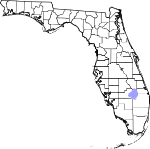
I had to look and see where the "Nature Coast" is (counties in red)...didn't recognize that one.
To get an idea of where citrus growing areas are concentrated...and where a freeze would be a serious problem...are shown below. So far, doesn't appear..as of now...that a hard freeze is being shown in these areas by any current model runs.
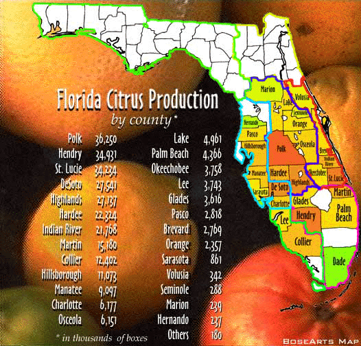
To get an idea of where citrus growing areas are concentrated...and where a freeze would be a serious problem...are shown below. So far, doesn't appear..as of now...that a hard freeze is being shown in these areas by any current model runs.
0 likes
-
frankthetank
- Category 2
- Posts: 527
- Joined: Mon Aug 09, 2004 6:16 pm
- Location: La Crosse, WI
Re: Florida Weather Thread: cooler pattern
10 days out is still a long time. Lets hope it trends warmer for my visit to the sunshine state (although i'm acclimated to single digits, so even 60F will feel warm).
0 likes
Re: Florida Weather Thread: cooler pattern
Where in florida are you headed....huge difference in winter weather (even normal temps) from the Panhandle to South Florida in the Keys.
NWS Miami Discussion now using 'slightly cooler' to describe front early next week...and they use the magic words: flip flop!
A REINFORCEMENT OF SLIGHTLY COOLER AND
DRYER AIR WILL MOVE THROUGH MONDAY NIGHT. THERE HAS BEEN A FLIP
FLOP IN THE GFS40 FROM THE PREVIOUS SEVERAL RUNS AND NOW THE MEX
MOS SHOWS A WARMER SOLUTION AND THE COLDEST MORNING TUESDAY
MORNING AND NOT WEDNESDAY MORNING. WILL NOT CHANGE THE EXTENDED
ATTM DUE TO THE AMOUNT OF UNCERTAINTY.
Looking at the numbers (no doubt these would be very agreeable temps compared to where you will be coming from!):
NWS Forecast for: Miami FL
Issued by: National Weather Service Miami - South Florida
Last Update: 6:07 pm EST Jan 8, 2009
________________________________________
Tonight: Clear, with a low around 58. Northwest wind around 11 mph.
Friday: Sunny, with a high near 75. North wind around 11 mph.
Friday Night: Partly cloudy, with a low around 63. East wind between 8 and 11 mph.
Saturday: Mostly sunny, with a high near 77. Southeast wind between 8 and 11 mph.
Saturday Night: Partly cloudy, with a low around 64. South wind around 7 mph.
Sunday: A 10 percent chance of showers after 9am. Partly cloudy, with a high near 76.
Sunday Night: A 10 percent chance of showers. Partly cloudy, with a low around 61.
Monday: A 10 percent chance of showers. Partly cloudy, with a high near 76.
Monday Night: Partly cloudy, with a low around 63.
Tuesday: Mostly sunny, with a high near 73.
Tuesday Night: Partly cloudy, with a low around 57.
Wednesday: Mostly sunny, with a high near 68.
Wednesday Night: Partly cloudy, with a low around 55.
Thursday: Mostly sunny, with a high near 72.
frankthetank wrote:10 days out is still a long time. Lets hope it trends warmer for my visit to the sunshine state (although i'm acclimated to single digits, so even 60F will feel warm).
0 likes

Re: Florida Weather Thread: cooler pattern
It looks like the arctic blast for S Florida has now become a cool down whenever it gets here. No big deal.At least I don't have to run my ac next week.
FOR NEXT WEEK MOST MODEL GUIDANCE SUGGESTS SOME AMPLIFICATION IN THE
LONGWAVE PATTERN ACROSS NOAM...BUT THERE ARE SOME DIFFERENCES IN THE
DETAILS. THE GFS MOVES THE AFOREMENTIONED COLD FRONT ACROSS SOUTH FL
MONDAY BEFORE STALLING IT ACROSS THE STRAITS...BUT THE ECMWF AND NAM
SEEM A LITTLE FURTHER NORTH WITH THE UPPER SUPPORT ASSOCIATED WITH
THIS SYSTEM AND AS A RESULT STALL THE FRONT ACROSS NORTH/CENTRAL FL.
THE ECMWF THEN WAITS FOR THE NEXT STRONGER PIECE OF ENERGY DIGGING
INTO THE EASTERN CONUS TROUGH TO PUSH THE FRONT THROUGH DURING THE
MID WEEK PERIOD. THE GFS SOLUTION IS ALSO SUPPORTED BY THE 12Z/08
RUNS OF THE CMC AND GFS ENSEMBLE MEMBERS...SO IT WILL BE INTERESTING
TO SEE WHAT PLAYS OUT THE NEXT FEW DAYS. THE GFS SOLUTION WOULD NOT
APPEAR TO BRING MORE THAN ISOLD SHOWERS TO THE REGION MONDAY...WHILE
THE ECMWF SOLUTION WOULD BRING SLIGHTLY BETTER RAIN CHANCES TO THE
MID WEEK PERIOD. GIVEN THE UNCERTAINTY...WILL NOT MAKE MANY
SIGNIFICANT CHANGES TO THE EXTENDED FCST AT THIS TIME...BUT A
COOLER AIRMASS WILL LIKELY WORK ACROSS SOUTH FL BEHIND THIS FRONT
WHENEVER IT PASSES THROUGH.
0 likes

Re: Florida Weather Thread: cooler pattern
Yep...as of now, the lowest low temp in the NWS Miami 6-Day Outlook is 55 deg....pretty much like we saw this morning, with highs in the 70s throughout the period. Thought we would finally break the 50 deg mark in the next week...may have to wait a bit more i guess...of course, things can change.
boca wrote:It looks like the arctic blast for S Florida has now become a cool down whenever it gets here. No big deal.At least I don't have to run my ac next week.
FOR NEXT WEEK MOST MODEL GUIDANCE SUGGESTS SOME AMPLIFICATION IN THE
LONGWAVE PATTERN ACROSS NOAM...BUT THERE ARE SOME DIFFERENCES IN THE
DETAILS. THE GFS MOVES THE AFOREMENTIONED COLD FRONT ACROSS SOUTH FL
MONDAY BEFORE STALLING IT ACROSS THE STRAITS...BUT THE ECMWF AND NAM
SEEM A LITTLE FURTHER NORTH WITH THE UPPER SUPPORT ASSOCIATED WITH
THIS SYSTEM AND AS A RESULT STALL THE FRONT ACROSS NORTH/CENTRAL FL.
THE ECMWF THEN WAITS FOR THE NEXT STRONGER PIECE OF ENERGY DIGGING
INTO THE EASTERN CONUS TROUGH TO PUSH THE FRONT THROUGH DURING THE
MID WEEK PERIOD. THE GFS SOLUTION IS ALSO SUPPORTED BY THE 12Z/08
RUNS OF THE CMC AND GFS ENSEMBLE MEMBERS...SO IT WILL BE INTERESTING
TO SEE WHAT PLAYS OUT THE NEXT FEW DAYS. THE GFS SOLUTION WOULD NOT
APPEAR TO BRING MORE THAN ISOLD SHOWERS TO THE REGION MONDAY...WHILE
THE ECMWF SOLUTION WOULD BRING SLIGHTLY BETTER RAIN CHANCES TO THE
MID WEEK PERIOD. GIVEN THE UNCERTAINTY...WILL NOT MAKE MANY
SIGNIFICANT CHANGES TO THE EXTENDED FCST AT THIS TIME...BUT A
COOLER AIRMASS WILL LIKELY WORK ACROSS SOUTH FL BEHIND THIS FRONT
WHENEVER IT PASSES THROUGH.
0 likes
Re: Florida Weather Thread: cooler pattern
I think well get cold fronts here in Florida over the next 10 days but nothing extreme.highs in the 70's lows in the 50's.Other than the Jan 3rd 2008 event the cold fronts have been benign here in South Florida.I've been monitoring the GFS and the NAM over the last week or so.
0 likes
-
gatorcane
- S2K Supporter
- Posts: 23708
- Age: 48
- Joined: Sun Mar 13, 2005 3:54 pm
- Location: Boca Raton, FL
Re: Florida Weather Thread: cooler pattern
boca wrote:I think well get cold fronts here in Florida over the next 10 days but nothing extreme.highs in the 70's lows in the 50's.Other than the Jan 3rd 2008 event the cold fronts have been benign here in South Florida.I've been monitoring the GFS and the NAM over the last week or so.
Looking at ECMWF and GFS long-range for the past week or so, its readily apparent that there is debate on when and how strong the arctic air intrusion is going to be. Right now, its likely Florida is going to see BELOW normal temperatures for much of the last two weeks in January. I don't see any record-breaking arctic blasts that will penetrate deep into Florida but there is no doubt that the long-wave pattern is in the process of changing that should keep Florida and much of the East Coast of the US on a cooler pattern starting early next week possibly, lasting 10-14 days thereafter. It reminds me some of the 1-2 weeks of below normal weather all of S. Florida experience in Nov.
0 likes
-
frankthetank
- Category 2
- Posts: 527
- Joined: Mon Aug 09, 2004 6:16 pm
- Location: La Crosse, WI
Re: Florida Weather Thread: cooler pattern
Also looks extremely DRY... according to the GFS.
I can handle 70F no problem... Looking for ward to that wonderful Miami traffic in my rental car
I can handle 70F no problem... Looking for ward to that wonderful Miami traffic in my rental car
0 likes
Re: Florida Weather Thread: cooler pattern
Watching the trend...NWS Miami forecast lows for next week keeping going up....lowest temp forecasted next week was 48 deg on wednesday's forecast, 52 deg on yesterday's forecast, 55 deg on this morning's forecast, and now is up to a 'lowest low' of 57 deg next week.
NWS Forecast for: Miami FL
Issued by: National Weather Service Miami - South Florida
Last Update: 3:53 pm EST Jan 9, 2009
------------------------------------------------------------------------------
Tonight: Mostly clear, with a low around 64. East wind between 7 and 13 mph.
Saturday: Mostly sunny, with a high near 78. East wind between 6 and 10 mph.
Saturday Night: Partly cloudy, with a low around 67.
Sunday: A 10 percent chance of showers after 8am. Partly cloudy, with a high near 79.
Sunday Night: A 20 percent chance of showers. Partly cloudy, with a low around 61.
Monday: A 10 percent chance of showers. Partly cloudy, with a high near 76.
Monday Night: Partly cloudy, with a low around 57.
Tuesday: Mostly sunny, with a high near 75.
Tuesday Night: Mostly clear, with a low around 57.
Wednesday: Mostly sunny, with a high near 76.
Wednesday Night: Partly cloudy, with a low around 60.
Thursday: Mostly sunny, with a high near 76.
Thursday Night: Partly cloudy, with a low around 60.
Friday: Mostly sunny, with a high near 73.
0 likes
-
Extremeweatherguy
- Category 5
- Posts: 11095
- Joined: Mon Oct 10, 2005 8:13 pm
- Location: Florida
Re: Florida Weather Thread: cooler pattern
The 18z GFS is back to showing a cold pattern for Florida next week. This run depicts a low near freezing in Orlando next Friday morning along with 850mb temperatures as low as -4˚C by Friday afternoon.
Also: It is worth noting that JB thinks that McAllen, TX and/or Orlando, FL will fall to 27F or colder within the next 10 days. 27F or below would be a hard freeze, which is a rarity for both locations. It will be interesting to see if he is correct.
Also: It is worth noting that JB thinks that McAllen, TX and/or Orlando, FL will fall to 27F or colder within the next 10 days. 27F or below would be a hard freeze, which is a rarity for both locations. It will be interesting to see if he is correct.
0 likes
-
JonathanBelles
- Professional-Met

- Posts: 11430
- Age: 35
- Joined: Sat Dec 24, 2005 9:00 pm
- Location: School: Florida State University (Tallahassee, FL) Home: St. Petersburg, Florida
- Contact:
Return to “USA & Caribbean Weather”
Who is online
Users browsing this forum: No registered users and 47 guests