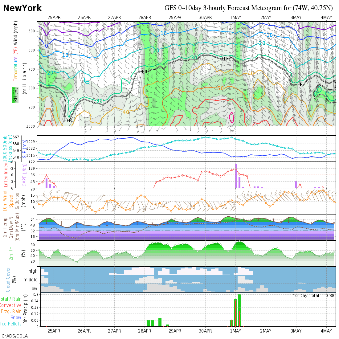
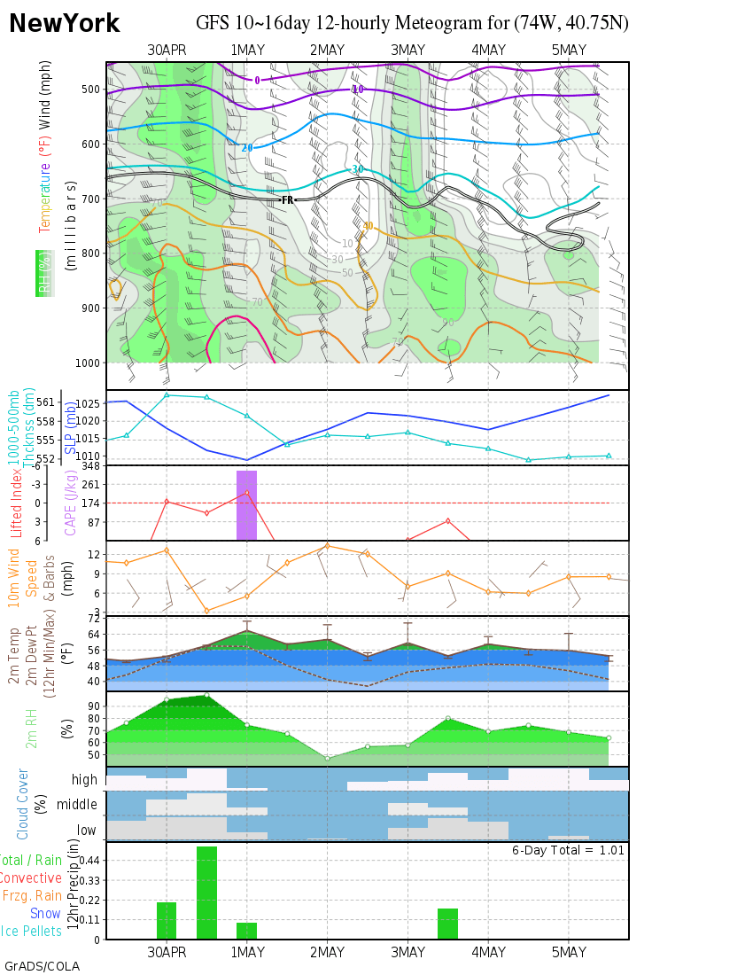
The 12Z GFS 2 meter temps suggests NYC doesn't break freezing for daytime highs (or not by very much) for 2 straight weeks starting tomorrow, with a couple of sub-freezing nights, as not seen since 1994.
Plus, of course, the happy Canadian Atlanta to Trenton mega-snow storm.
Southern Plains winter wx thread (2008-2009)
Moderator: S2k Moderators
Forum rules
 The posts in this forum are NOT official forecast and should not be used as such. They are just the opinion of the poster and may or may not be backed by sound meteorological data. They are NOT endorsed by any professional institution or STORM2K.

The posts in this forum are NOT official forecast and should not be used as such. They are just the opinion of the poster and may or may not be backed by sound meteorological data. They are NOT endorsed by any professional institution or STORM2K.
-
Ed Mahmoud
Re: One or more arctic blasts on the way?
Almost two weeks straight below freezing in NYC (per GFS)
0 likes
-
srainhoutx

- S2K Supporter

- Posts: 6919
- Age: 68
- Joined: Sun Jan 14, 2007 11:34 am
- Location: Haywood County, NC
- Contact:
Re: One or more arctic blasts on the way?
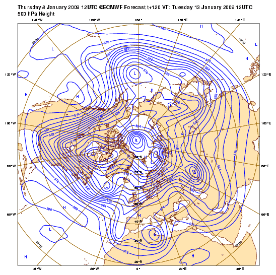
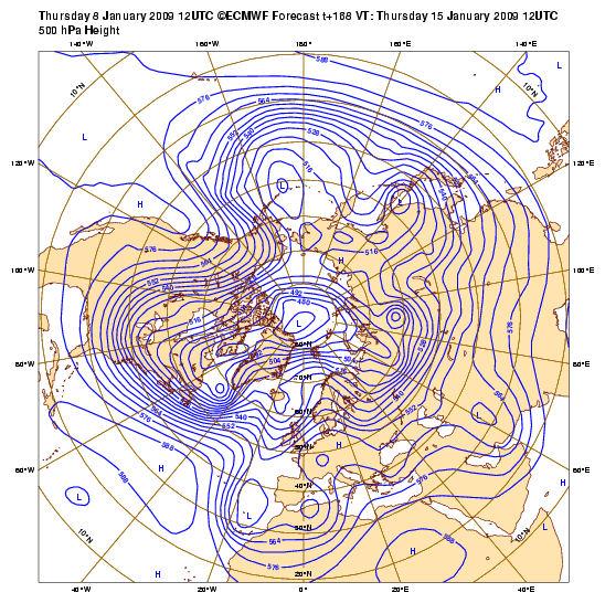
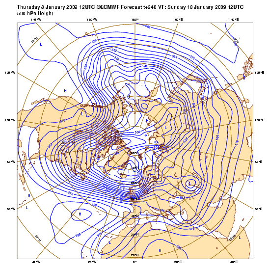
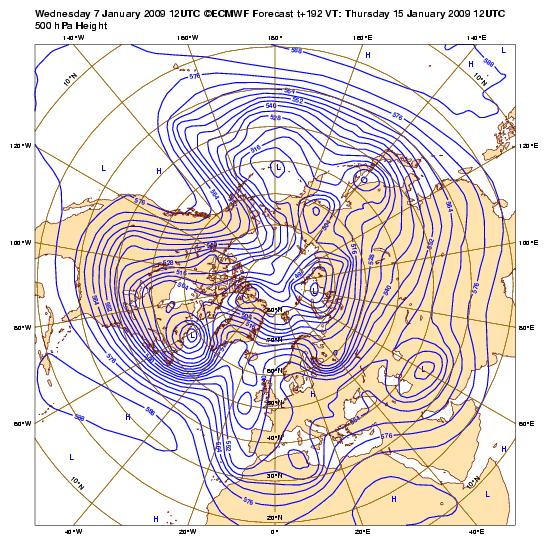
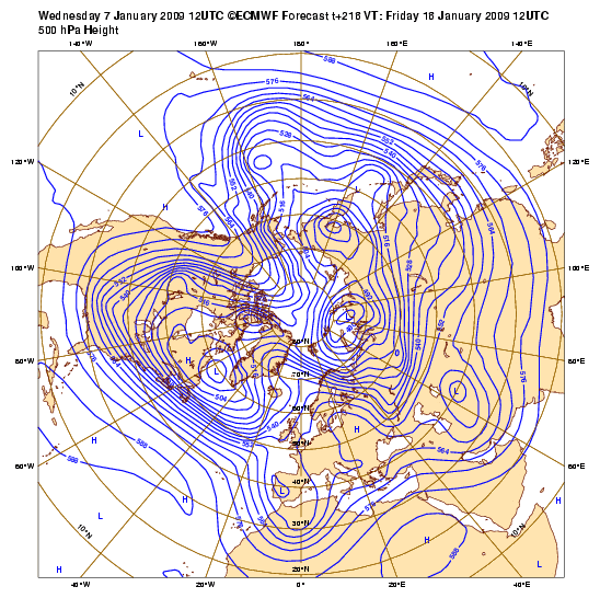
12Z ECMWF Today...500mb...
120 Hours...
144 Hours...

168 Hours...
192 Hours...
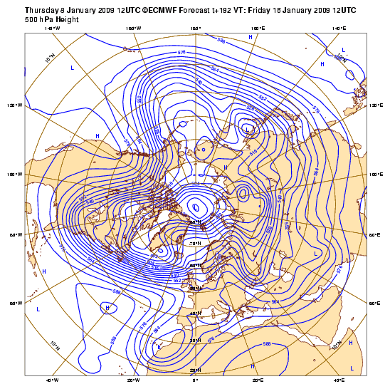
216 Hours...
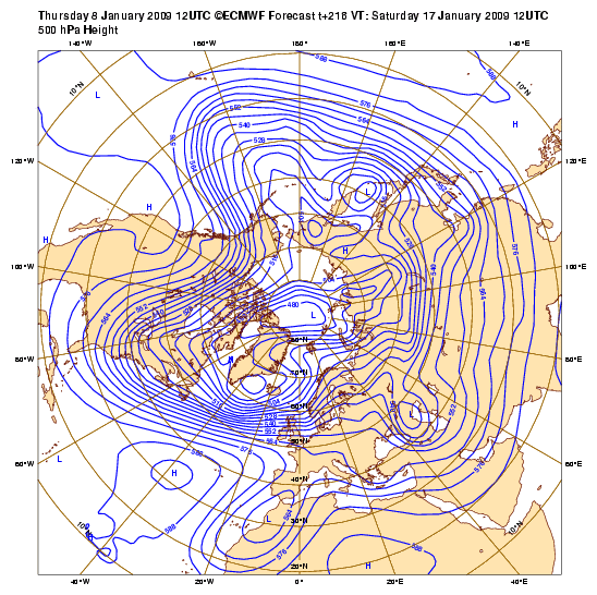
240 Hours...
12Z ECMWF Yesterday...
168 hours
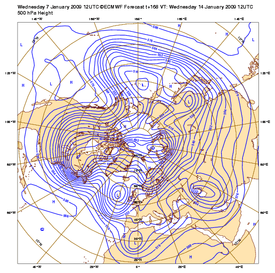
192 hours
216 hours
Remember to use you head and not your heart when viewing these differences. Models are just tools in the vast meteorological tool bag.
120 Hours...
144 Hours...
168 Hours...
192 Hours...
216 Hours...
240 Hours...
12Z ECMWF Yesterday...
168 hours
192 hours
216 hours
Remember to use you head and not your heart when viewing these differences. Models are just tools in the vast meteorological tool bag.
0 likes
-
srainhoutx
- S2K Supporter
- Posts: 6919
- Age: 68
- Joined: Sun Jan 14, 2007 11:34 am
- Location: Haywood County, NC
- Contact:
Re: One or more arctic blasts on the way?
HPC's thoughts this afternoon...
EXTENDED FORECAST DISCUSSION
NWS HYDROMETEOROLOGICAL PREDICTION CENTER CAMP SPRINGS MD
229 PM EST THU JAN 08 2009
VALID 12Z SUN JAN 11 2009 - 12Z THU JAN 15 2009
...STRONG PNA PATTERN WITH ARCTIC AIR DOMINATING THE PATTERN E OF
THE ROCKIES...
THE LONGWAVE PATTERN CAN BEST BE DESCRIBED AS PNA(W COAST
RIDGE/ERN NOAM TROF). IT WILL BE SLOWLY PROGRESSIVE WITH SOME
AMPLIFICATION AT LEAST INTO THE MID PORTION OF NEXT WEEK. IF ONE
LEANS TOWARDS THE ECMWF FAMILY OF SOLUTIONS...RIDGING MIGHT
CONTINUE OVER WRN CANADA/ERN ALASKA INTO WED/THU.
DOWNSTREAM OF THE MEAN RIDGE JUST OFF THE W COAST OF NOAM...A
BROAD MEAN DEEP TROF WILL KEEP THE ERN HALF OF THE CONUS IN THE
ICEBOX...WITH ONLY BRIEF INTERRUPTIONS. THE MAIN UNCERTAINTIES
CONCERN THE DEPTH/TIMING OF SHORTWAVE FEATURES TOPPING THE MEAN
LONGWAVE RIDGE POSITION NEAR THE CANADIAN W COAST...THEN RACING SE
INTO THE REAR OF THE WRN NOAM TROF. THE BIGGEST FORECAST PROBLEM
WILL BE HOW MUCH THE LONGWAVE RIDGE IS DENTED OVER ERN ALASKA/NW
CANADA MON...AND HOW MUCH HEIGHTS SUBSEQUENTLY FALL IN THE N
CENTRAL STATES TUE-THU IN THE REAR OF THE LONGWAVE ERN NOAM TROF
POSITION.
ON THE SPAGHETTI PLOTS...THE ECMWF ENSEMBLE MEMBERS PROMINENTLY
SHOW MORE HEIGHT FALL DROPPING SE INTO THE NRN HIGH PLAINS BY WED
IN CONTRAST TO THE DETERMINISTIC GFS AND ITS ENSEMBLE MEMBERS. BY
THU DAY 7 THE ECMWF ENSEMBLE MEMBERS REPRESENT THE MOST CYCLONIC
SIDE OF THE ENVELOPE OF SOLUTIONS IN THE CENTRAL AND NRN HIGH
PLAINS. NOT SURPRISINGLY UPSTREAM...THEY ARE ON THE MORE
ANTICYCLONIC SIDE OF THE ENVELOPE OF SOLUTIONS OVER ERN ALASKA.
FOR OUR FINAL GRAPHICS...WE ARE STICKING WITH UPDATED PRELIM
SURFACE GRAPHICS WHICH WERE A BLEND OF 00Z/08 ECMWF AND ECMWF
ENSEMBLE MEAN. HOWEVER GIVEN THAT THE CYCLONIC CURVATURE IN THE
MEAN SENSE IS RATHER BROAD THRU THE HIGH PLAINS...WE ARE SKEPTICAL
OF ANY MODEL OR ENSEMBLE MEMBER SOLUTION THAT SHOWS MUCH SHORTWAVE
AMPLITUDE IN THE HIGH PLAINS REGION THE LATTER PORTION OF NEXT
WEEK.
THE 12Z/08 GFS HAS MADE A DRASTIC CHANGE BY DAY 5 IN REBUILDING
THE RIDGE OFF THE W COAST FARTHER W THAN ITS OWN
CONTINUITY...ALLOWING SHORTWAVE ENERGY TOPPING THE RIDGE TO DROP
FARTHER W THAN ITS 00Z CONTINUITY MORE LIKE THE 00Z ECMWF.
WHILE WE ACCEPT ITS TREND IN THE N CENTRAL AND CENTRAL ROCKIES/PLAINS
TUE/WED DAYS 5-6...WE THINK THAT IT RAISES HEIGHTS MUCH TOO
QUICKLY ALONG THE E COAST. ONE SIGNIFICANT CHANGE...WHICH WE WILL
BE WATCHING CLOSELY..IS THAT BOTH THE 12Z/08 ECMWF AND CANADIAN
ARE PLAYING UP THE SRN END OF AN UPPER TROF MORE AS IT CROSSES THE
MS VLY TUE DAY 5...AND BRIEFLY RAISE HEIGHTS OFF THE E COAST AHEAD
OF THIS TROF.
HIGHLIGHTS:
THE POSITION OF THE STRONG MEAN RIDGE OFF THE NW COAST IS
FAVORABLE FOR HOT DRY SANTA ANNA WINDS IN CA AT LEAST INTO DAY 5.
THE BUILDING HIGH OFF THE PACIFIC NW COAST WILL ALSO SHOVE ANY
PRECIP N INTO BC AND THE ALASKAN PANHANDLE. ONE SYS MOVING ACROSS
THE UPPER OH VLY INTO SRN NEW ENG SUN WILL BE FOLLOWED BY
MODERATELY COLD AIR AND SOME LAKE EFFECT SN SHOWERS. THE NEXT
COMPLEX SYS APPROACHING THE E COAST STATES DAY 5 WILL DRAG DOWN
COLDER AIR SWD BEHIND IT THAN THE PREVIOUS SYS. THIS COULD BRING
THE SEASONS FIRST MEASURABLE SN TO PORTIONS OF NC/VA AND BE
FOLLOWED BY MORE LAKE EFFECT SN SHOWERS. FINALLY...THE
GFS/ECMWF/CANADIAN ALL SHOW A CLIPPER TYPE SYS RACING SE FROM THE
HIGH PLAINS INTO THE MIDWEST DAYS 5-6 TURNING EWD THEREAFTER. SOME
OF THE COLDEST AIR OF THE SEASON MAY FOLLOWS IN THE WAKE OF THE
CLIPPER SYS IN THE N CENTRAL STATES WED/THU WITH BITTER WIND
CHILLS.
FLOOD
0 likes
-
gatorcane

- S2K Supporter
- Posts: 23708
- Age: 48
- Joined: Sun Mar 13, 2005 3:54 pm
- Location: Boca Raton, FL
Re: One or more arctic blasts on the way?
0 likes
-
Extremeweatherguy

- Category 5

- Posts: 11095
- Joined: Mon Oct 10, 2005 8:13 pm
- Location: Florida
http://news.yahoo.com/s/ap/20090108/ap_ ... treme_cold
Wow!
If it is cold enough to cancel ski events in ALASKA, then you know its an extreme event. lol.
JUNEAU, Alaska – Ted Johnson planned on using a set of logs to a build a cabin in Alaska's interior. Instead he'll burn some of them to stay warm.
Extreme temperatures — in Johnson's case about 60 below zero — call for extreme measures in a statewide cold snap so frigid that temperatures have grounded planes, disabled cars, frozen water pipes and even canceled several championship cross country ski races.
Alaskans are accustomed to subzero temperatures but the prolonged conditions have folks wondering what's going on with winter less than a month old.
National Weather Service meteorologist Andy Brown said high pressure over much of central Alaska has been keeping other weather patterns from moving through. New conditions get pushed north or south while the affected area faces daily extremes.
"When it first started almost two weeks ago, it wasn't anything abnormal," Brown said. "About once or twice every year, we get a good cold snap. But, in this case, you can call this an extreme event. This is rare. It doesn't happen every year."
Temperatures sit well below zero in the state's various regions, often without a wisp of wind pushing down the mercury further.
Johnson lives in Stevens Village, where residents have endured close to two weeks of temperatures pushing 60 below zero.
The cold has kept planes grounded, Johnson said. Food and fuel aren't coming in and they're starting to run low in the village, about 90 miles northwest of Fairbanks.
Johnson, whose home has no heater or running water, said he ventures outside only to get more logs for burning and to fetch water from a community facility. He's been saving the wood to build a cabin as a second home, but that will have to wait a few years now because the heat takes precedence.
"I've never seen it this cold for this long," he said. "I remember it 70 below one time, but not for a week and a half."
In Anchorage, Alaska's largest city, residents are used to lows of about 10-degree temperatures in January — not 19 below zero, which is what folks awoke to Wednesday morning.
Temperatures finally settled to about 10 below at midday, but that was cold enough to cancel races in the U.S. Cross Country Ski Championships.
Skiers won't compete unless it's warmer than 4 below zero, but the numbers have ranged between 10 below and 15 below.
That has led to four days of canceled or postponed competition with organizers hoping to get a set of races under way on Thursday, the event's final day.
Meanwhile, in Juneau, the state's capital is enjoying balmy weather by comparison with lows in the single digits.
Wow!
If it is cold enough to cancel ski events in ALASKA, then you know its an extreme event. lol.
0 likes
-
Dave

- Retired Staff

- Posts: 13442
- Age: 75
- Joined: Tue Aug 01, 2006 3:57 pm
- Location: Milan Indiana
- Contact:
From the NWS office at Chicago IL:
http://www.crh.noaa.gov/wxstory.php?site=lot
"After a relatively tranquil period today and this evening, the winter of '08-'09 is forecast to kick into high gear. An Alberta clipper system is expected to bring accumulating snow...mainly Friday and Friday night. Another system could bring additional snow on Monday before the gates of the Arctic open toward the Midwest and Great Lakes, plunging the area into a subzero deep freeze by midweek."
Nothing from the Indianapolis IN, Louisville KY, or Wilmington OH offices yet.
0 likes
-
gatorcane
- S2K Supporter
- Posts: 23708
- Age: 48
- Joined: Sun Mar 13, 2005 3:54 pm
- Location: Boca Raton, FL
well the 18Z GFS is trending with the 12Z -- forecasting a cold weather pattern for the EC CONUS that is not quite as brutal as past runs....looks like there will be colder weather in the East for sure, but certainly is trending warmer with each run and keeps pushing back the arrival of the arctic front which makes me wonder if and when it will really arrive. Now we are back out around day 7 or beyond for the EC of the CONUS....which is not really that accurate this far out anyway:
Most of the energy stays in Canada....
Those that want the arctic blast, well it is climatologically the time of year to see one so....

Out about 216 hours (which is usually pretty inaccurate) we finally see the major trough --- but wow what a change from the past couple of days which brought the trough into the East much quicker....hmmm it reminds me of how the GFS forecasts its usual phantom major hurricanes (which don't come to fruition) to form in the Western Carib for most of hurricane season...

Most of the energy stays in Canada....
Those that want the arctic blast, well it is climatologically the time of year to see one so....
Out about 216 hours (which is usually pretty inaccurate) we finally see the major trough --- but wow what a change from the past couple of days which brought the trough into the East much quicker....hmmm it reminds me of how the GFS forecasts its usual phantom major hurricanes (which don't come to fruition) to form in the Western Carib for most of hurricane season...
0 likes
-
Extremeweatherguy
- Category 5
- Posts: 11095
- Joined: Mon Oct 10, 2005 8:13 pm
- Location: Florida
-
Stormcenter
- S2K Supporter
- Posts: 6689
- Joined: Wed Sep 03, 2003 11:27 am
- Location: Houston, TX
-
Texas Snowman

- Storm2k Moderator

- Posts: 6197
- Joined: Fri Jan 25, 2008 11:29 am
- Location: Denison, Texas
Re: One or more arctic blasts on the way?
I don't mean to offend anyone, but this is becoming almost as good as the "wobble watching" wars that occur during hurricane season. (And I've been guilty of doing that as much as anyone!  )
)
But sometimes, I think that it's time to forget watching the model runs flip-flop and it becomes time to pay attention to some good old fashioned meterology.
My take - there's a pile of extreme cold air sitting up north just waiting to come roaring south.
And given the OKC NWS discussion snippet this morning ("NOT TOO MANY TIMES DO WE SEE COLDER AIRMASS SHIFT EAST AS QUICKLY AS GFS SHOWS. IT USUALLY DIVES SOUTH... HUGGING HIGHER TERRAIN AS IT MOVES DOWN THE PLAINS.") I think it is pretty reasonable to expect that everyone from the Great Plains to the east will be in for a big time blue norther.
I'm betting that this air mass will take aim at N. Texas and SE Texas, if not all the way down to the Rio Grande Valley.
My .02 cents worth.
Tx Snowman
0 likes
Re:
And we need models to tell us that in mid-January? Really the question is who will see the heart of whatever cold air comes from the north....it is definitely not a foregone conclusion that this will be a nationwide arctic invasion resulting in large and uniform departures from normal in temp from coast to coast.
Alot can change in 5 days....more in 10 days....and so on....in just 24 hours we have seen some flip flopping of the models...the exact weather that will result in any "Point X" is a moving target with each run this far out.
Excerpt from this evening's NWS Miami Discussion
THERE HAS BEEN A FLIP
FLOP IN THE GFS40 FROM THE PREVIOUS SEVERAL RUNS AND NOW THE MEX
MOS SHOWS A WARMER SOLUTION AND THE COLDEST MORNING TUESDAY
MORNING AND NOT WEDNESDAY MORNING. WILL NOT CHANGE THE EXTENDED
ATTM DUE TO THE AMOUNT OF UNCERTAINTY.
Stormcenter wrote:Bottom line is it's going to get cold. The only concern (if you want to call it that
0 likes
-
srainhoutx
- S2K Supporter
- Posts: 6919
- Age: 68
- Joined: Sun Jan 14, 2007 11:34 am
- Location: Haywood County, NC
- Contact:
Re: One or more arctic blasts on the way?
Texas Snowman wrote:I don't mean to offend anyone, but this is becoming almost as good as the "wobble watching" wars that occur during hurricane season. (And I've been guilty of doing that as much as anyone!
But sometimes, I think that it's time to forget watching the model runs flip-flop and it becomes time to pay attention to some good old fashioned meterology.
My take - there's a pile of extreme cold air sitting up north just waiting to come roaring south.
And given the OKC NWS discussion snippet this morning ("NOT TOO MANY TIMES DO WE SEE COLDER AIRMASS SHIFT EAST AS QUICKLY AS GFS SHOWS. IT USUALLY DIVES SOUTH... HUGGING HIGHER TERRAIN AS IT MOVES DOWN THE PLAINS.") I think it is pretty reasonable to expect that everyone from the Great Plains to the east will be in for a big time blue norther.
I'm betting that this air mass will take aim at N. Texas and SE Texas, if not all the way down to the Rio Grande Valley.
My .02 cents worth.
Tx Snowman
Agreed.
HPC's Alaska Update offers some "hints" of things to come with a bit of "humor" concerning the models...
ALASKA EXTENDED FORECAST DISCUSSION
NWS HYDROMETEOROLOGICAL PREDICTION CENTER CAMP SPRINGS MD
153 PM EST THU JAN 08 2009
VALID 12Z MON JAN 12 2009 - 12Z FRI JAN 16 2009
LOOKS LIKE A MAJOR CHANGE TO THE PATTERN NEXT WEEK IN THE MEDIUM
RANGE AS AN UPPER RIDGE BUILDS ACROSS THE STATE...LIKELY ENDING
THE PERIOD OF EXTREME COLD FOR MUCH OF THE STATE. IN THE
SHORTRANGE...A MAJOR FLIP FLOP IN THE OPERATIONAL MODELS ON DAY
4/MONDAY.
FIRST THINGS FIRST. THE MODELS HAVE DONE A COMPLETE FLIP ON A
SYSTEM MOVING NORTH FROM THE EASTCENTRAL PACIFIC ON DAY 4/MONDAY.
THE OPERATIONAL GFS HAD BEEN VERY CONSISTENT IN BRINGING A
DEEPENING CYCLONE TOWARD SW ALASKA ON MONDAY...BUT THE 12Z GFS HAS
SHIFTED TOWARD WHAT THE OPERATIONAL EUROPEAN HAD BEEN SHOWING ALL
ALONG...A RELATIVELY WEAK OPEN WAVE MOVING TOWARD SE ALASKA.
THE OPERATIONAL EUROPEAN ALSO HAD BEEN CONSISTENT IN BRINGING A
WEAKER WAVE TOWARD THE PANHANDLE...EXCEPT AT 00Z. NOW...THE 12Z
LOOKS A LOT LIKE THE OLD GFS WHILE THE GFS LOOKS LIKE THE OLD
EUROPEAN WITH A RAPIDLY INTENSIFYING CYCLONE HEADED FOR KODIAK
ISLAND...WITH THE 12Z CANADIAN AND UKMET IN LINE. I PROMISE NOT
TO SHOOT MYSELF.
THE MANUAL GRAPHICS...WHICH WERE MADE BEFORE THE 12Z EUROPEAN WAS
RECEIVED...HAS A COMPROMISE SOLUTION BETWEEN SW AND SE ALASKA WITH
A SYSTEM IN THE GULF. I HAVE NO IDEA HOW TO RECONCILE THE NEW
CHANGES IN THE MODELS.
THE BIGGER PICTURE IS NOT NEARLY SO CHANGEABLE AND SHOWS THAT THIS
SYSTEM IS A MERE BLIP IN THE OVERALL AMPLIFICATION OF THE UPPER
RIDGE OVER THE EASTERN PACIFIC AT THE SAME TIME THAT HEIGHTS DROP
DRAMATICALLY OVER EASTERN SIBERIA...AND THE MOVEMENT OF A
DEEPENING TROUGH/CUTOFF LOW ACROSS THE NORTH PACIFIC TO A POSITION
NEAR THE EASTERN ALEUTIANS/EASTERN BERING SEA LATER IN THE MEDIUM
RANGE. THESE ARE THE PRIMARY DRIVERS OF THE CHANGES TO COME THAT
ARE SHOWING UP NOT ONLY IN ALASKA BUT IN MUCH OF THE LOWER 48.
THESE LARGER SCALE CHANGES ARE SIMILARLY PREDICTED BY ALL ENSEMBLE
SYSTEMS AND ARE MORE PREDICTABLE IN THEIR OVERALL MOVEMENT.
AS THE LARGE LOW MOVING ACROSS THE PACIFIC PASSES SOUTH OF THE
EASTERN ALEUTIANS BY DAY 6/WEDNESDAY...MILDER AIR SURGES NORTH
ACROSS MUCH OF THE NE PACIFIC REACHING THE SOUTHERN SHORE OF THE
STATE AND THEN SURGES NORTHWARD ACROSS THE STATE AS THE UPPER
RIDGE BECOMES DOMINANT ACROSS EASTERN ALASKA AND WESTERN CANADA.
WHILE ALASKA IS LOSING ITS COLD...MUCH OF THE EASTERN HALF OF THE
LOWER 48 IS FORECAST TO TURN MUCH COLDER.
KOCIN
0 likes
-
vbhoutex

- Storm2k Executive

- Posts: 29143
- Age: 74
- Joined: Wed Oct 09, 2002 11:31 pm
- Location: Cypress, TX
- Contact:
Re: One or more arctic blasts on the way?
Texas Snowman wrote:I don't mean to offend anyone, but this is becoming almost as good as the "wobble watching" wars that occur during hurricane season. (And I've been guilty of doing that as much as anyone!
But sometimes, I think that it's time to forget watching the model runs flip-flop and it becomes time to pay attention to some good old fashioned meterology.
My take - there's a pile of extreme cold air sitting up north just waiting to come roaring south.
And given the OKC NWS discussion snippet this morning ("NOT TOO MANY TIMES DO WE SEE COLDER AIRMASS SHIFT EAST AS QUICKLY AS GFS SHOWS. IT USUALLY DIVES SOUTH... HUGGING HIGHER TERRAIN AS IT MOVES DOWN THE PLAINS.") I think it is pretty reasonable to expect that everyone from the Great Plains to the east will be in for a big time blue norther.
I'm betting that this air mass will take aim at N. Texas and SE Texas, if not all the way down to the Rio Grande Valley.
My .02 cents worth.
Tx Snowman
That pretty much says it for me too. Yes I would be in line for the "Arctic Blast" if this comes to fruition as stated here, but that doesn't mean I am -removed-. I think it is a reasonable analysis. What it probably means for those to the East and North of my area(everywhere else but Texas basically) is a possibly more prolonged bout of extreme cold than some are expecting. Like most here that do know about the models and how they work or don't work, as the case may be, I don't get too worked up this far out, but I definitely begin to watch when I see some of the consistency I have seen(even with the flip flops that have happened and will happen). This all shouldn't be too big a surprise for many as we are still not to the "middle" of the winter season yet.
0 likes

Re: One or more arctic blasts on the way?
New run of the GFS shows Texas getting in on the fun late next week, looks pretty cold. I'm still not convinced that it will be THAT cold, it has shown it getting this cold before then gradually warmed the airmass up as it got closer.
0 likes


-
Ed Mahmoud
Re: One or more arctic blasts on the way?
0Z GFS 2 meter temps (from AccuWx PPV) -23ºC in NYC on January 16
-8ºF Farenheit.
-8ºF Farenheit.
0 likes
-
Ed Mahmoud
Re: One or more arctic blasts on the way?
Canadian likes coldest air over G'lakes and Northeast...

This is out 6 days, PSU e-Wall hasn't updated yet, but has Canadian out 10 days on 0Z run...
This is out 6 days, PSU e-Wall hasn't updated yet, but has Canadian out 10 days on 0Z run...
0 likes
Re: One or more arctic blasts on the way?
Dallas Noaa Discussion.
Boo for no snow or ice, although things can change, maybe they'll start showing more precip. Either way I'll take the cold, I'm tired of this 70 degree weather in Jan.
Oh and Yikes, from the OKC discussion.
I
WE ARE IN STORE FOR A BIG CHANGE LATTER HALF OF NEXT WEEK AS A BROAD
TROUGH OVER MUCH OF NOAM SENDS COLD ARCTIC AIR DOWN INTO THE REGION.
RELIABLE COMPUTER MODELS ARE STILL HAVING A DIFFICULT TIME
DETERMINING JUST HOW COLD IT WILL BE. THE AIR MASS ORIGINATES IN
NORTHERN AND EASTERN ALASKA WHERE DAYTIME TEMPS HAVE BEEN MINUS 20
TO MINUS 45+ DEGREES. GIVEN THAT WE ARE NOW IN THE DEAD OF
WINTER...STRENGTH OF A RIDGE BUILDING OFF THE WEST COAST...A
MCFARLAND PATTERN SETUP NORMALLY RESULTS IN SOME OF THE COLDEST
TEMPERATURES OF WINTER...THUS WE WILL FOLLOW THE GFS AND UNDER MOS
GUIDANCE NUMBERS SIGNIFICANTLY FOR THURSDAY AND FRIDAY. FORECAST
SOUNDING DO NOT INDICATE ANY POTENTIAL FOR SNOW OR ICE WITH THE
ARCTIC AIR. 75
Boo for no snow or ice, although things can change, maybe they'll start showing more precip. Either way I'll take the cold, I'm tired of this 70 degree weather in Jan.
Oh and Yikes, from the OKC discussion.
I
N YUKON ARE A
FORESHADOW OF THE 1057MB HIGH PRESSURE DEVELOPED BY THE GFS IN THE
DAKOTAS BY THURSDAY. OKLAHOMA AND ADJACENT PARTS OF TEXAS MAY SEE
OVERNIGHT TEMPERATURES IN THE SINGLE DIGITS AND MAXIMA IN THE 20S.
DRY WEATHER IS EXPECTED THROUGH THIS PERIOD.
0 likes
-
Portastorm

- Storm2k Moderator
- Posts: 9954
- Age: 63
- Joined: Fri Jul 11, 2003 9:16 am
- Location: Round Rock, TX
- Contact:
Re: One or more arctic blasts on the way?
Good morning all! Seems like Lucy is now outside the house, with the football, and asking us if we want to come outside and kick the football!!
As already posted, the GFS has become more bullish on next week's Arctic Outbreak with a broad trough over much of the eastern half of the USA, while the European is still on board but has a more Eastern-centered trough. Regardless, and as astutely pointed out by others here, this Arctic air is so cold and so dense that it will probably overwhelm any jet pattern.
Here is a comparison of the 500 mb flow at 0z Wednesday (Jan. 14) by the GFS and then the Euro.
GFS:

Euro:

0 likes
Who is online
Users browsing this forum: KirbyDude25, wxman22 and 76 guests