NWS Miami already backing off on the cold front's impact through at least Thursday. Mentions possibility of stalling out, with the given 'let's keep an eye as things can change'.
But if 'the trend is your friend', this is 'day 2' of a reduced impact at least in terms of parts of florida (south for now)....lowest low temp forecast for next 6 days for Miami went from 48 deg as of Wednesday evening's update, up to 52 deg as of last night's update, and now up to 55 deg as of this morning (forecast for Wedneday night).
Southern Plains winter wx thread (2008-2009)
Moderator: S2k Moderators
Forum rules
 The posts in this forum are NOT official forecast and should not be used as such. They are just the opinion of the poster and may or may not be backed by sound meteorological data. They are NOT endorsed by any professional institution or STORM2K.

The posts in this forum are NOT official forecast and should not be used as such. They are just the opinion of the poster and may or may not be backed by sound meteorological data. They are NOT endorsed by any professional institution or STORM2K.

Re: One or more arctic blasts on the way?
jinftl wrote:NWS Miami already backing off on the cold front's impact through at least Thursday. Mentions possibility of stalling out, with the given 'let's keep an eye as things can change'.
But if 'the trend is your friend', this is 'day 2' of a reduced impact at least in terms of parts of florida (south for now)....lowest low temp forecast for next 6 days for Miami went from 48 deg as of Wednesday evening's update, up to 52 deg as of last night's update, and now up to 55 deg as of this morning (forecast for Wedneday night).
Jinftl by Sat the way the trend is heading I'd say the low will be 65 deg for Wed night.We just can't get a good cold snap down here like we used to in the 70s and 80s.If and when the NAO goes negative we might start seeing more significant cold fronts down here.Example lows in the 30's highs in the mid 50s.That's some crisp air for Florida.
0 likes
-
Extremeweatherguy

- Category 5

- Posts: 11095
- Joined: Mon Oct 10, 2005 8:13 pm
- Location: Florida
Re: One or more arctic blasts on the way?
boca wrote:jinftl wrote:NWS Miami already backing off on the cold front's impact through at least Thursday. Mentions possibility of stalling out, with the given 'let's keep an eye as things can change'.
But if 'the trend is your friend', this is 'day 2' of a reduced impact at least in terms of parts of florida (south for now)....lowest low temp forecast for next 6 days for Miami went from 48 deg as of Wednesday evening's update, up to 52 deg as of last night's update, and now up to 55 deg as of this morning (forecast for Wedneday night).
Jinftl by Sat the way the trend is heading I'd say the low will be 65 deg for Wed night.We just can't get a good cold snap down here like we used to in the 70s and 80s.If and when the NAO goes negative we might start seeing more significant cold fronts down here.Example lows in the 30's highs in the mid 50s.That's some crisp air for Florida.
Just so you know, the NAO is currently negative and has been for some time now.
http://www.cpc.noaa.gov/products/precip ... .sprd2.gif
0 likes
-
vbhoutex

- Storm2k Executive

- Posts: 29143
- Age: 74
- Joined: Wed Oct 09, 2002 11:31 pm
- Location: Cypress, TX
- Contact:
Re: One or more arctic blasts on the way?
Portastorm wrote:Good morning all! Seems like Lucy is now outside the house, with the football, and asking us if we want to come outside and kick the football!!
As already posted, the GFS has become more bullish on next week's Arctic Outbreak with a broad trough over much of the eastern half of the USA, while the European is still on board but has a more Eastern-centered trough. Regardless, and as astutely pointed out by others here, this Arctic air is so cold and so dense that it will probably overwhelm any jet pattern.
Here is a comparison of the 500 mb flow at 0z Wednesday (Jan. 14) by the GFS and then the Euro.
GFS:
Euro:


That normally is the case. No matter where you live East of the Rockies it appears that there are indeed some very cold days ahead. The question for those of us in the South is just how cold? Appears many areas of the North and East part of the US East of the Rockies will be seeing some very extended Extreme(what I consider extreme)cold.
0 likes
-
Portastorm

- Storm2k Moderator

- Posts: 9954
- Age: 63
- Joined: Fri Jul 11, 2003 9:16 am
- Location: Round Rock, TX
- Contact:
The 12z GFS is running now and looks much like the 0z run. Check out the maps at 132 hours. Look at how those isotherms are packed!!
http://www.nco.ncep.noaa.gov/pmb/nwprod/analysis/namer/gfs/12/fp0_132.shtml
http://www.nco.ncep.noaa.gov/pmb/nwprod/analysis/namer/gfs/12/fp0_132.shtml
0 likes
-
Stormcenter
- S2K Supporter

- Posts: 6689
- Joined: Wed Sep 03, 2003 11:27 am
- Location: Houston, TX
Re:
I think it's now safe to say that it will get pretty chilly in the south for the next week or so.
Portastorm wrote:The 12z GFS is running now and looks much like the 0z run. Check out the maps at 132 hours. Look at how those isotherms are packed!!
http://www.nco.ncep.noaa.gov/pmb/nwprod/analysis/namer/gfs/12/fp0_132.shtml
0 likes
-
SaskatchewanScreamer
-
PTrackerLA

- Category 5
- Posts: 5281
- Age: 42
- Joined: Thu Oct 10, 2002 8:40 pm
- Location: Lafayette, LA
Re: One or more arctic blasts on the way?
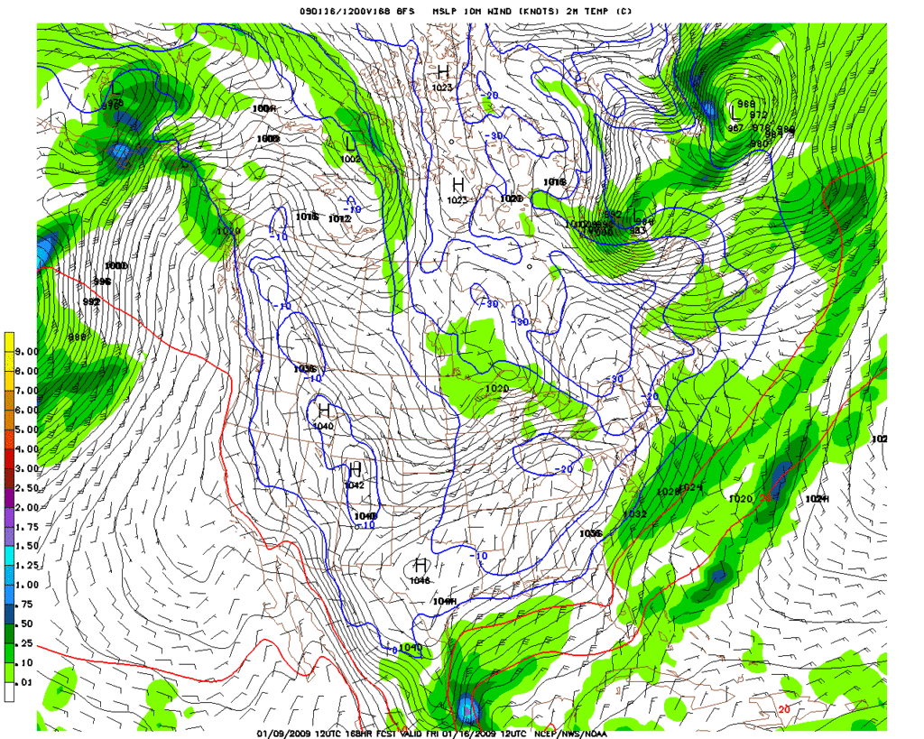
The 12z GFS shows precip possibly ending in the frozen form on Thursday followed by the entire day Friday below freezing. Would certainly be an impressive event.
http://www.nco.ncep.noaa.gov/pmb/nwprod ... n_156m.gif
http://www.nco.ncep.noaa.gov/pmb/nwprod ... n_156m.gif
0 likes
-
Ed Mahmoud
Re: One or more arctic blasts on the way?
PTrackerLA wrote:The 12z GFS shows precip possibly ending in the frozen form on Thursday followed by the entire day Friday below freezing. Would certainly be an impressive event.
http://www.nco.ncep.noaa.gov/pmb/nwprod ... n_156m.gif
I don't see any winter fun for LFT as it looks like precip ends about the same time as it gets cold enough for snow or sleet and ground would still be warm. But it is a week away, and an couple of inches of frozen precip on the ground before a day long plus sub-freezing spell, reflecting sunlight back into space during the day, and keeping the heat of the Earth from warming things at night.
Don't give up hope!

0 likes
-
srainhoutx

- S2K Supporter
- Posts: 6919
- Age: 68
- Joined: Sun Jan 14, 2007 11:34 am
- Location: Haywood County, NC
- Contact:
Re: One or more arctic blasts on the way?
Looks mighty cold for a lot of folks E of the Rockies...
0 likes
-
Ed Mahmoud
Re: One or more arctic blasts on the way?
But not all hope is lost. If the GFS is basically correct, but the cold air is a couple of degrees colder (which is possible with poor GFS resolution) and moves 6 or 12 hours faster, then maybe just enough freezing rain to make the I-10 corridor bridges and overpasses a sight to behold!
0 likes
-
srainhoutx
- S2K Supporter
- Posts: 6919
- Age: 68
- Joined: Sun Jan 14, 2007 11:34 am
- Location: Haywood County, NC
- Contact:
Re: One or more arctic blasts on the way?
HPC thoughts today...
EXTENDED FORECAST DISCUSSION
NWS HYDROMETEOROLOGICAL PREDICTION CENTER CAMP SPRINGS MD
225 PM EST FRI JAN 09 2009
VALID 12Z MON JAN 12 2009 - 12Z FRI JAN 16 2009
FINAL MEDIUM RANGE DISCUSSION....
NEW 12Z MODEL DATA...ESPECIALLY THE 12Z ECMWF...SUPPORTED OUR
DECISION TO LEAVE THE UPDATED PRLIM GRAPHIC LARGELY UNCHANGED. THE
12Z GFS BACKED OFF ON THE EXTREME DEEPENING OF THE POLAR VORTEX
OVER SERN CANADA FOR DAY 7 FROM ITS 06Z RUN.
THE MODELS ARE IN BETTER THAN AVERAGE AGREEMENT ON THE LARGE SCALE
FLOW ACROSS THE CONUS DURING THE MEDIUM RANGE PERIOD...WITH AN
UNUSUALLY HIGH AMPLITUDE WEST COAST RIDGE AND EASTERN
CANADIAN/GREAT LAKES TROUGH DEVELOPING. WE ARE LESS CONFIDENT IN
THE SMALLER SCALE SHORTWAVE PATTERN SINCE THERE ARE FREQUENT
SHORTWAVES RACING THRU THE BROAD MEAN NOAM TROF. IT IS THIS
UNCERTAINTY CONCERNING SHORTWAVE FEATURES THAT PERSUADES US TO
CONTINUE USING A GOOD PERCENTAGE OF THE ECMWF ENSEMBLE MEAN EVEN
AT THE BEGINNING OF THE MEDIUM RANGE PERIOD. THE 00Z...06Z...AND
12Z/09 GEFS ENSEMBLE MEANS GIVE GOOD SUPPORT TO THE 00Z/09 ECMWF
ENSEMBLE MEAN. ENSEMBLE SPAGHETTI PLOTS STRONGLY SUGGEST THAT IN
THIS PATTERN OF HIGH CONFIDENCE IN THE LARGE SCALE FEATURES...AND
LOW TO MODERATE CONFIDENCE IN SMALLER SCALE IMPULSES...THE CENTER
OF THE ENVELOPE OF SOLUTIONS IS A GOOD PLACE TO BE.
12Z MODELS: THE NEW 12Z GFS IS IN SYNC WITH ITS PREVIOUS RUN. THE
CANADIAN IS MORE LIKE THE 12Z/00Z ECWMF...WHILE THE UKMET HAS ITS
OWN LOW CONFIDENCE SHORTWAVE SCENARIO IN THE FAST CYCLONIC FLOW.
HOWEVER THE 12Z GFS IS STILL A HALF DAY FASTER THAN OUR
ECMWF/ECMWF ENSEMBLE MEAN BLEND IN MOVING THE CLIPPER SYS ACROSS
THE MIDWEST INTO THE NRN MID ATLANTIC STATES DAYS 5-6. THE NEW
12Z/09 ECMWF IS QUITE CONSISTENT WITH ITS TIMING OF THIS FEATURE
FROM ITS 00Z RUN...AND SUPPORTS OUR DECISION TO STAY WITH THE
00Z/09 ECMWF/ECMWF ENSEMBLE MEAN BLEND USED FOR THE UPDATED
PRELIM.
HIGHLIGHTS: TWO CLIPPER SYS DURING THE NEXT 5 DAYS OVER THE ERN
THIRD OF THE NATION WILL EACH PULL DOWN COLD AIR IN THEIR WAKE.
THE AIR BEHIND THE SECOND CLIPPER WILL BE A BIT COLDER THAN THE
AIR BEHIND THE FIRST ONE. THE FOLLOWING CLIPPER SYS MOVING ACROSS
THE UPPER MIDWEST TO THE NRN MID ATLANTIC THU/FRI DAYS 5-6 WILL
USHER IN A VERY FRIGID ARCTIC AIRMASS IN ITS WAKE WITH BITTER COLD
WIND CHILLS. EXPECT A STRIPE OF SN TO THE LEFT OF THE TRACKS OF
THESE CLIPPER SYS.
WHILE THE ERN HALF OF THE NATION STAYS MOSTLY IN THE ICEBOX...THE
VERY STRONG RIDGE ALOFT OVER THE W COAST STATES...PARTICULARLY
OVER THE PACIFIC NW...WILL FAVOR WARM DRY SANTA ANNA WINDS ALMOST
EVERY DAY FOR CA. PARADOXICALLY...THE FLOW AROUND THE FAR SW
FRINGE OF THE MASSIVE COLD ARCTIC HIGH SETTLING SWD THRU THE
NATIONS MIDSECTION MIGHT BE THE MECHANISM TO RE-ENFORCE OFFSHORE
FLOW WITH COMPRESSIONAL WARMING ALONG THE CA COAST DAYS 6-7.
FLOOD
0 likes
-
Portastorm
- Storm2k Moderator
- Posts: 9954
- Age: 63
- Joined: Fri Jul 11, 2003 9:16 am
- Location: Round Rock, TX
- Contact:
Re: One or more arctic blasts on the way?
Well sports fans, the 12z Euro is much like the 0z run. Yet, there is conventional meteorological wisdom that suggests an airmass this dense, this cold, will plunge due south along the slope of the Rockies. Wxman57 has spoken to it in winters past on this board and has alluded to it once again recently on the KHOU board.
Is this one of those times we blow off the models in the face of conventional wisdom? The Euro is usually so good during the winter months, it is hard for me to go against it.
Thoughts? Comments?
Will we be Florida Gator fans and have our winter wishes come true, or will we end up OU fans and suffer disappointment, once again?
0 likes
-
gboudx

- S2K Supporter
- Posts: 4090
- Joined: Thu Sep 04, 2003 1:39 pm
- Location: Rockwall, Tx but from Harvey, La
Re: One or more arctic blasts on the way?
Portastorm wrote:Will we be Florida Gator fans and have our winter wishes come true, or will we end up OU fans and suffer disappointment, once again?
Pray to St. Tebow for whichever pattern you are wishing for.
0 likes
-
Ed Mahmoud
Re: One or more arctic blasts on the way?
Portastorm wrote:Well sports fans, the 12z Euro is much like the 0z run. Yet, there is conventional meteorological wisdom that suggests an airmass this dense, this cold, will plunge due south along the slope of the Rockies. Wxman57 has spoken to it in winters past on this board and has alluded to it once again recently on the KHOU board.
Is this one of those times we blow off the models in the face of conventional wisdom? The Euro is usually so good during the winter months, it is hard for me to go against it.
Thoughts? Comments?
Will we be Florida Gator fans and have our winter wishes come true, or will we end up OU fans and suffer disappointment, once again?
I wnated OU to win for Big XII pride, and it was a good game, but the look on Boob Stops face in the fourth quarter did a lot to ease my pain.
Just had my attention called to a -25ºC dewpoint in Waco, TX per GFS next Friday morning by a poster on the KHOU forum. The static electricity will be horrible.
0 likes
-
srainhoutx
- S2K Supporter
- Posts: 6919
- Age: 68
- Joined: Sun Jan 14, 2007 11:34 am
- Location: Haywood County, NC
- Contact:
Re: One or more arctic blasts on the way?
Portastorm wrote:Well sports fans, the 12z Euro is much like the 0z run. Yet, there is conventional meteorological wisdom that suggests an airmass this dense, this cold, will plunge due south along the slope of the Rockies. Wxman57 has spoken to it in winters past on this board and has alluded to it once again recently on the KHOU board.
Is this one of those times we blow off the models in the face of conventional wisdom? The Euro is usually so good during the winter months, it is hard for me to go against it.
Thoughts? Comments?
Will we be Florida Gator fans and have our winter wishes come true, or will we end up OU fans and suffer disappointment, once again?
Well Portastorm, I have been watching closely this "predicted" Artic Outbreak. One thing that does have my attention is the fact the EC is setting up a cross polar flow from Siberia. Another interesting issue is placement of the Polar Vortex. I do believe that the models will be everywhere the next couple of days until synoptic issues are resolved. It does appear certain that a very strong W Coast Ridge is developing. That ridge and where it sets up is one key. Another is the issues of Short Waves rotating into the Central CONUS. I suspect that a couple of strong Artic Highs will slide right along the lee side of the Rockies. Something to watch as the weekend approaches. Stay tuned. It's going to get Cold and possibly Very Cold for a lot of folks.
0 likes
-
vbhoutex
- Storm2k Executive
- Posts: 29143
- Age: 74
- Joined: Wed Oct 09, 2002 11:31 pm
- Location: Cypress, TX
- Contact:
Re: One or more arctic blasts on the way?
NEVER AS LONG AS THE SUN SHINES IN THE SKY!!!!Will we be Florida Gator fans and have our winter wishes come true, or will we end up OU fans and suffer disappointment, once again?
Now back to your other comments. I have been watching this scenario as it slowly unfolds with much interest. I will almost always go with conventional wisdom of times past and climatology when it comes to "Arctic Outbreaks" unless there is overwhelming evidence that there is no way the plunge will happen. I haven't seen anything that tells me it won't happen and much that indicates it will, much which is addressed in previous posts. Will it go East and miss the Southern Plains and Texas? Conventional wisdom, etc. goes against this scenario. Most often air masses such as this do overwhelm any existing pattern which might blunt its progress. Will the East be much colder than the area West of the Mississippi? Not necessarily, but with the set up already in place to pull in Arctic air from the NE Canadian regions it will probably last a good while longer in the Eastern portions of the Conus. How cold will it get in the Southland? Who knows? Normally with an air mass this dense and long lasting(it has been entrenched in Eastern Alaska and the Yukon for weeks), when the do have the mechanism that breaks them lose it is "Katy bar the door" until they make it far enough South(into the Caribbean often) for the air to moderate and warm. Teens in Houston? Possible? Yes, definitely, but this far out I will be comfortable with expecting low 20's all the way to the Gulf Coast and I do mean all the way to the Florida panhandle. In fact that area may be colder than the areas west of NO with the possibility of some of the NE air reinforcing that areas temps. Teens in N. Florida would not be a huge surprise if the plunge does happen(those type of temps have been mentioned by Jeff Lindner in one of his emails). Anyway, that is this amatuers take on this for what it is worth. Anyone with better knowledge and analytical skills than mine(and there are many)feel free to tear this apart. JMHO.
0 likes
-
Hurricane_Apu
- Tropical Storm

- Posts: 124
- Joined: Tue Aug 31, 2004 5:47 pm
Re: One or more arctic blasts on the way?
There are still quite a few people... even well north and east of Texas... who aren't quite buying into this outbreak yet. From the Wilmington (SW Ohio) NWS 5:00 PM disco:
ARCTIC AIR MAY INVADE LATER IN THE
PERIOD...BUT CURRENT MODELS ARE A COUPLE DAYS LATER WITH THE
ANTICIPATED COLD SNAP. KEEPING RATHER HIGH UNCERTAINTY IN
MIND...HIGHS WEDNESDAY THROUGH FRIDAY ARE FORECAST TO BE IN THE
TEENS AND 20S (i.e. 10-15 degrees below normal but nothing extraordinary)...
ARCTIC AIR MAY INVADE LATER IN THE
PERIOD...BUT CURRENT MODELS ARE A COUPLE DAYS LATER WITH THE
ANTICIPATED COLD SNAP. KEEPING RATHER HIGH UNCERTAINTY IN
MIND...HIGHS WEDNESDAY THROUGH FRIDAY ARE FORECAST TO BE IN THE
TEENS AND 20S (i.e. 10-15 degrees below normal but nothing extraordinary)...
0 likes
-
Ed Mahmoud
Re: One or more arctic blasts on the way?
Quitting time, but 18Z GFS 2 meter temps in NYC Friday morning are -6º F, which is darned cold by NYC standards.
0 likes
Re: One or more arctic blasts on the way?
No doubt it can happen...but a pattern set up that would bring highs in the 50's and lows in the 30's to Miami is an outlier-type event. A negative NAO doesn't mean Miami sees a freeze event without question...rather, an extreme outlier type version of such a pattern would be needed. Below normal temps in Miami could mean a high of 74 and a low of 56. That's 3 deg below normal.
Extremeweatherguy wrote:boca wrote:jinftl wrote:NWS Miami already backing off on the cold front's impact through at least Thursday. Mentions possibility of stalling out, with the given 'let's keep an eye as things can change'.
But if 'the trend is your friend', this is 'day 2' of a reduced impact at least in terms of parts of florida (south for now)....lowest low temp forecast for next 6 days for Miami went from 48 deg as of Wednesday evening's update, up to 52 deg as of last night's update, and now up to 55 deg as of this morning (forecast for Wedneday night).
Jinftl by Sat the way the trend is heading I'd say the low will be 65 deg for Wed night.We just can't get a good cold snap down here like we used to in the 70s and 80s.If and when the NAO goes negative we might start seeing more significant cold fronts down here.Example lows in the 30's highs in the mid 50s.That's some crisp air for Florida.
Just so you know, the NAO is currently negative and has been for some time now.
http://www.cpc.noaa.gov/products/precip ... .sprd2.gif
0 likes