Southern Plains winter wx thread (2008-2009)
Moderator: S2k Moderators
Forum rules
 The posts in this forum are NOT official forecast and should not be used as such. They are just the opinion of the poster and may or may not be backed by sound meteorological data. They are NOT endorsed by any professional institution or STORM2K.
 The posts in this forum are NOT official forecast and should not be used as such. They are just the opinion of the poster and may or may not be backed by sound meteorological data. They are NOT endorsed by any professional institution or STORM2K.
- Extremeweatherguy
- Category 5

- Posts: 11095
- Joined: Mon Oct 10, 2005 8:13 pm
- Location: Florida
Re:
Extremeweatherguy wrote:JB is predicting the possibility of teens to the I-10 corridor from IAH to TLH, and the possibility of 27F or lower all the way to Orlando and McAllen at some point over the next 10 days. If he is correct, then there will be a lot of shivering going on in the south.
I would love to see low 20s over here in NE Florida. (while looking outside from my 70F heated house)
0 likes
-
JonathanBelles
- Professional-Met

- Posts: 11430
- Age: 35
- Joined: Sat Dec 24, 2005 9:00 pm
- Location: School: Florida State University (Tallahassee, FL) Home: St. Petersburg, Florida
- Contact:
Re: Re:
jdray wrote:Extremeweatherguy wrote:JB is predicting the possibility of teens to the I-10 corridor from IAH to TLH, and the possibility of 27F or lower all the way to Orlando and McAllen at some point over the next 10 days. If he is correct, then there will be a lot of shivering going on in the south.
I would love to see low 20s over here in NE Florida. (while looking outside from my 70F heated house)
Oh come on. Walk out in some shorts, you only get to do it once or twice a year! jk
0 likes
-
PurdueWx80
- Professional-Met

- Posts: 2720
- Joined: Fri Aug 13, 2004 8:33 pm
- Location: Madison, WI
- Contact:
i personally think the central/south florida freeze scenario can't happen until the week of the 19th. that la nina ridge over the caribbean is probably going to protect them until then. that's not to say it won't be cooler than normal as the highs come down, but they're weakening quite rapidly (unlike when we were in this pattern during late november), so the northerly flow will lose its punch. south texas is a different story, though.
for obvious reasons, i'm curious to see how this pattern breaks down in a couple of weeks. i'm not looking forward to next week at all since i commute by public transit and spend a lot of time outside. we're getting our snowpack back here in madison (those clippers next week scare me), so that'll make the cold that much worse. anyway, seems to me the eastern trough will eventually retrograde back to the west or northwest via clippers chipping away at the eastern side of the east pacific ridge. i'll just pretend to ignore what that means for the upper midwest....for now.
for obvious reasons, i'm curious to see how this pattern breaks down in a couple of weeks. i'm not looking forward to next week at all since i commute by public transit and spend a lot of time outside. we're getting our snowpack back here in madison (those clippers next week scare me), so that'll make the cold that much worse. anyway, seems to me the eastern trough will eventually retrograde back to the west or northwest via clippers chipping away at the eastern side of the east pacific ridge. i'll just pretend to ignore what that means for the upper midwest....for now.
0 likes
-
Siberian Express
- S2K Supporter

- Posts: 99
- Joined: Tue Sep 27, 2005 9:13 pm
- Location: Minnesota, USA
Re: One or more arctic blasts on the way?
I really hope you all get what your looking for. It's been cold for a month here, now I'm looking for global warming. It gets old quick.
0 likes
- wxman22
- Category 5

- Posts: 1848
- Joined: Mon Jan 30, 2006 12:39 am
- Location: Wichita Falls, TX
- Contact:
Re: One or more arctic blasts on the way?
Seems like the GFS has bring back the Southern snowstorm it showed a few days ago...


And then it becomes a Nor'easter...


And then it becomes a Nor'easter...


0 likes
-
Ed Mahmoud
Re: One or more arctic blasts on the way?
wxman22 wrote:Seems like the GFS has bring back the Southern snowstorm it showed a few days ago...
And then it becomes a Nor'easter...
Of course, that is almost two weeks out, but looking at the better resolution stuff on my AccuWx PPV web site, thay looks a lot like the Blizzard of 1888, so wound up BOS turns to rain, while NYC stays (barely) snow. That, is, of course, quite rare.
AccuWx PPV subscribers can see this:

Of course, we are beyond 180 hours and into reduced T number/resolution GFS fantasy land. But I still like it.
0 likes
Re: One or more arctic blasts on the way?
If this scenario plays out as projected then we are in deep trouble here along the Gulf coast. Our infrastructure is not equipped nor our homes insulated against these predicted temperatures and certainly not more than a dusting of snow every 4 years. Heck, we don't even own "real" winter coats. Our winter coast consist of a liner in our London Fog rain jacket or the old standby "hunting" camo jackets. LOL
0 likes
-
Ed Mahmoud
Re: One or more arctic blasts on the way?
Euro (from PSU e-Wall through Friday)
glancing blow of cold air for Texas, but an interesting development, surface low tracking near 850 mb -15º isotherm.
Look at the Ucellini and Koscin book, most big East Coast storms that snow in Northeast have surface low fairly close to 850 mb freezing line.
I think Joe Bastardi mentioned this earlier today in a discussion, a storm mid week where there is no rain in the 'warm sector', heaviest snow falls along and South of the storm track, with lighter snow North of it.

0 likes
-
Ed Mahmoud
Re: One or more arctic blasts on the way?
Well, I gotta stick with my 24º F for Friday AM HOU temp as seen earlier in KHOU forum post, because a unofficial bet is an unoffical bet, but the GFS, Euro and Canadian all seem in glancing territory.
I'd say upper 20s now, at the worst. And probably Thursday morning now, not Friday morning.
BTW, ECWMF.int web site has a bonus freebie, 2 meter temps in Upper Left hand corner, and poor graphics and color scale, and it looks like Friday morning temps between -16º and -20ºC for NYC, which would be chilly for the area.

0 likes
-
Ed Mahmoud
Re: One or more arctic blasts on the way?
New Canadian has a glancing blow mid-week, and model ends at tau 144 with the jet in position for a glancing blow from a second Arctic high, but it looks like that nearly 1060 mb high is trying to buck the flow a bit and head more South then the mean flow, so maybe a more solid glancing blow for Texas.
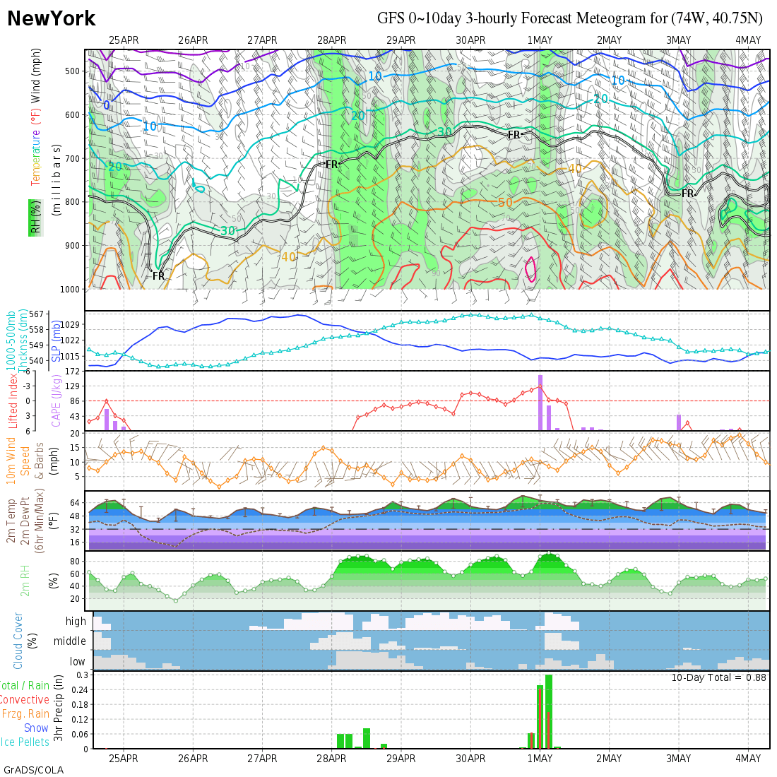
Now, I know we are all Texas (or Florida, if we live there, or North Carolina) centric, but the Canadian shows 498 DM thickness and about -22ºC 850 mb temps. Very, very close to the 12Z 850 GFS temps and thicknesses, and using my handy AccuWx PPV, I see close to -23ºC 2 meter temps in the NYC area.
Almost -10ºF. Coldest in NYC since 1934.
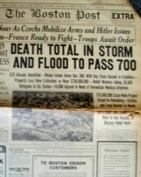
This is the Winter equivalent of a Cat 3 hitting West Hampton, New York. (ie, the 1938 New York/New England Hurricane ) for rareness.
OK, images of NYC approaching -10ºF wouldn't be as impressive as something else to express the magnitude of this forecasted event. It is a metaphor for the rareness of this cold outbreak.
Providence, RI 1938

Boston newspaper

Now, I know we are all Texas (or Florida, if we live there, or North Carolina) centric, but the Canadian shows 498 DM thickness and about -22ºC 850 mb temps. Very, very close to the 12Z 850 GFS temps and thicknesses, and using my handy AccuWx PPV, I see close to -23ºC 2 meter temps in the NYC area.
Almost -10ºF. Coldest in NYC since 1934.
This is the Winter equivalent of a Cat 3 hitting West Hampton, New York. (ie, the 1938 New York/New England Hurricane ) for rareness.
OK, images of NYC approaching -10ºF wouldn't be as impressive as something else to express the magnitude of this forecasted event. It is a metaphor for the rareness of this cold outbreak.
Providence, RI 1938

Boston newspaper

0 likes
-
Ed Mahmoud
Re: One or more arctic blasts on the way?
I don't think the forecasts in Knoxville are even close for next week. We have 'official' forecasts of around 15 for lows and around 30 for highs for 2 to 3 days.
Yet we've already had highs in the mid 20s and a low of around 10 earlier in the winter.
Judging that this will be a colder outbreak I would guess that by that very rule we would have to have temps lower than what we've already had. This is a rule that's worked for many winters for me as well. The GFS is giving us highs in the mid 10s and a low near 0 to 5 above for next Friday. Our official forecast? 15 to 28. I don't think so.
JB said this before and it's probably correct, the official forecasts out that far try to trend towards climatology so they aren't as wrong. Then what happens? They have to trend the temps lower with each day. I've seen this happen dozens of times in dozens of winters.
0 likes
- southerngale
- Retired Staff

- Posts: 27418
- Joined: Thu Oct 10, 2002 1:27 am
- Location: Southeast Texas (Beaumont area)
- PTrackerLA
- Category 5

- Posts: 5281
- Age: 42
- Joined: Thu Oct 10, 2002 8:40 pm
- Location: Lafayette, LA
Re: One or more arctic blasts on the way?
Looks like models are showing more and more of a glancing blow to south Louisiana. Seems these arctic airmasses almost always get shunted east. The panhandle of Florida will probably reach the teens while we may reach 25 here. Nothing too out of the ordinary. At least we're heading into a week of seasonable to below normal readings, we've been above normal almost every day since before Christmas!
0 likes
-
Ed Mahmoud
Re: One or more arctic blasts on the way?
Looks like Philly area gets down to about -5ºF, so some of my joy is for Category 5.
I don't need exciting weather to hit my house and kill my tender vegetation to get juiced up over it.
I don't need exciting weather to hit my house and kill my tender vegetation to get juiced up over it.
0 likes
- somethingfunny
- ChatStaff

- Posts: 3926
- Age: 37
- Joined: Thu May 31, 2007 10:30 pm
- Location: McKinney, Texas
Re: Re:
Ed Mahmoud wrote:southerngale wrote:Ed, are you going to be in NYC next week?
I wish. But besides airfare, I'd need more than a Houston style winter hoodie sweatshirt.
Wear two!
Underlying layers can make jeans and a hoodie mighty warm so long as your head's covered.
0 likes
-
Ed Mahmoud
Re: One or more arctic blasts on the way?
New Euro in, and this is far more rare than even snow in Houston, as Euro Friday morning looks remarkably similar in thicknesses and 850 mb temps to the Canadian and GFS.

About 495 thickness and -22ºC 850 mb temps. B-r-r-r-r-r.
The cold alone may provide a day of joy and no school for the students at my alma mater, St. Martin of Tours Parochial School in Amityville, NY.

About 495 thickness and -22ºC 850 mb temps. B-r-r-r-r-r.
The cold alone may provide a day of joy and no school for the students at my alma mater, St. Martin of Tours Parochial School in Amityville, NY.
0 likes
Who is online
Users browsing this forum: butch, cheezyWXguy, Stratton23 and 42 guests


