NWS Miami mentions the extreme dry weather south florida has been experiencing since last autumn....excerpt from tonight's Discussion...pretty amazing that in almost the last 90 days Fort Lauderdale has not seen a full inch of rain in total (since 11/1/08, 0.76" has fallen....less than an inch in a 1/4 of a year....keeping in mind the city averages about 60" of rain a year.....it's dry season so not much rain is expected, but this is crazy!)
CLIMATE...IT HAS BEEN VERY DRY LATELY. HERE ARE THE RAINFALL
TOTALS AT THE MAJOR REPORTING SITES SINCE NOV 1, 2008:
NAPLES...1.08" (DEPARTURE FROM NORMAL: -3.95")
WEST PALM BEACH...2.76" (DEPARTURE FROM NORMAL: -8.87")
FT. LAUDERDALE...0.76" (DEPARTURE FROM NORMAL: -8.70")
MIAMI...1.33" (DEPARTURE FROM NORMAL: -5.72")
Florida Weather
Moderator: S2k Moderators
Forum rules

The posts in this forum are NOT official forecast and should not be used as such. They are just the opinion of the poster and may or may not be backed by sound meteorological data. They are NOT endorsed by any professional institution or STORM2K.
-
JonathanBelles
- Professional-Met

- Posts: 11430
- Age: 35
- Joined: Sat Dec 24, 2005 9:00 pm
- Location: School: Florida State University (Tallahassee, FL) Home: St. Petersburg, Florida
- Contact:
Yea, I'm not sure as to why the Drought Monitor has most of Florida only in a D0 (abnormally dry). Here, I am in a D1 (moderate Drought), until the last week most grass what turning white. With the two frosts I had, most of the rest of the grass is brown now. I have pictures from the frost damage survey I took today. By June, I fear fire season.
0 likes
Re:
Florida KBDI Drought Index is about as high as it ever gets across the peninsula....readings average in the 200-450 range for wintertime in florida...current readings in the peninsula are 500+ in most places, over 600 in many areas even....without repeated rain events in the weeks ahead, this is an early indicator of potential forest fire threats this spring.

fact789 wrote:Yea, I'm not sure as to why the Drought Monitor has most of Florida only in a D0 (abnormally dry). Here, I am in a D1 (moderate Drought), until the last week most grass what turning white. With the two frosts I had, most of the rest of the grass is brown now. I have pictures from the frost damage survey I took today. By June, I fear fire season.
0 likes
The fire danger is going to go through the roof thanks to the drought and the freeze damage yielding plenty of flash fuels. alot of non maintained grass around here is just dead...not a trace of green. lake and stream levels are also very low...demonstrating long term drought. west central florida had a lousy rainy season in 08. while much of the state was swamped by Fay, we got nothing. I have a field of elephant grass in a powerline right of way close to me and it is totally dead thanks to drought and freezing conditions. the stuff is a 10 foot tall extreme fire hazard as is most of the state. by the time we get the fires out it will be hurricane season!
0 likes
-
HURRICANELONNY
- Category 5

- Posts: 1390
- Joined: Wed May 07, 2003 6:48 am
- Location: HOLLYWOOD.FL
Re: Florida Weather Thread: Warm up in store! Near 80 possible
I think La Nina is coming back. Not good. We need a strong El Nino. 
0 likes
-
frankthetank
- Category 2

- Posts: 527
- Joined: Mon Aug 09, 2004 6:16 pm
- Location: La Crosse, WI
Re: Florida Weather Thread: Warm up in store! Near 80 possible
If you read Ed Berry he seems to think La Nina is reloading. Watch out guys, i see another big high coming down over the gulf on the Euro. Doubt its like the last one, but "cold" weather is coming back to the great state of Florida.
http://weatherclimatelink.blogspot.com/


Not sure if anyone mentioned, but last Friday, Key West was 48F which was a new record low for that date.
http://weatherclimatelink.blogspot.com/
Not sure if anyone mentioned, but last Friday, Key West was 48F which was a new record low for that date.
0 likes


Re: Florida Weather Thread: Warm up in store! Near 80 possible
Even the frontal systems have been on the dry side this season....and then even drier air has been following the frontal passage. Essentially no rain in the forecast this week....although there is a 30% chance of showers in Tampa on Friday as front approaches....and a 20% chance in Miami according to latest NWS forecasts. No widespread and prolonged rain event for sure in the cards this week.
State of Florida is very aware of the situation that may be developing....excerpt from press release a few weeks ago (since then, KBDI reading for state overall has gone up to 537).
Bronson Warns Of Increasing Wildfire Threat;
Asks Public’s Help To Minimize Risk
TALLAHASSEE - Florida Agriculture and Consumer Services Commissioner Charles H. Bronson today advised residents that below average rainfall for the last four to five months has significantly increased the state’s wildfire risk.
The torrential rain associated with Tropical Storm Fay last summer has been all but offset by the recent drought. In fact, the Keetch-Byram Drought Index, which measures available soil moisture and runs from 0 (saturated) to 800 (desert-like), currently stands at 511 – more than double the normal drought index this time of year.
“We are asking both residents and visitors alike to be careful with any outdoor burning and to check with their local officials to determine if there is a burn ban in effect in their area,” Bronson said.
http://www.doacs.state.fl.us/press/2009/01072009.html
HURRICANELONNY wrote:I think La Nina is coming back. Not good. We need a strong El Nino.
0 likes
-
vbhoutex

- Storm2k Executive

- Posts: 29143
- Age: 74
- Joined: Wed Oct 09, 2002 11:31 pm
- Location: Cypress, TX
- Contact:
Re: Florida Weather Thread: Warm up in store! Near 80 possible
HURRICANELONNY wrote:I think La Nina is coming back. Not good. We need a strong El Nino.
You can have it after last year!!!
0 likes
-
feederband

- S2K Supporter

- Posts: 3423
- Joined: Wed Oct 01, 2003 6:21 pm
- Location: Lakeland Fl
Re: Re:
gatorcane wrote:Extremeweatherguy wrote:The forecast for Orlando tonight has been lowered to 26F. If that forecast plays out, then it will be the coldest reading the city has seen in years, even managing to beat the January 2003 event (27F).
Yes and as I commented before this winter season started, I was worried for those living in central Florida who have planted tropical plants that only belong in Southern Florida growing zones (south of the Lake)....
Looks like a total wipe-out of species such as Foxtail palms, coconut palms, and Royal Palms is about to take place anywhere north of Lake O

As far as Foxtails...I coverd them good with frost cloth...For some reason 3 other homes in the hood did not even attempt to cover anything...Thier Fox Tails are 100% dead... All 3 of Mine looks like I will have to trim off almost all the open leaves but looks like they will survive but it will take all Summer to get it looking like a Foxtail palm again...Triangle Palm took the same damage..
0 likes
-
gatorcane

- S2K Supporter
- Posts: 23708
- Age: 48
- Joined: Sun Mar 13, 2005 3:54 pm
- Location: Boca Raton, FL
Re:
psyclone wrote:I think the temps at PBI make perfect sense when viewed within the context of the map on the prior page and the report from the NWS. One thing is obvious from looking at that map... the temps in dade, broward and palm beach county vary widely and those 3 counties cannot be viewed the same way...palm beach is clearly much colder overall. A 4 degree misreading is huge and it wouldn't just exist on the coldest night of winter, it would exist all the time which means it probably would have been discovered long before now. Gatorcane, I think your "warm obsession" may be clouding your judgement here however if you truly believe official readings at PBI are 4 degrees too cold you should contact the national weather service in Miami with your concerns and let us know the results.
psyclone it is not true that Palm Beach is much colder than Broward and Miami-Dade overall. In fact if you look at the U.S growth zone map, metro Palm Beach County is in the same growth zone as Broward and Miami-Dade (except for an even warmer band that spans part of Central Broward). Just look around at the tropical plants that grow in Palm Beach County and they are similar to the ones that grow farther south (e.g. Royal Palms, coconut Palms, Foxtails, etc). Royal palms grow like weeds in Palm Beach County.
Most people would agree that you can "lump" Palm Beach County, Broward, and Miami-Dade together as part of SE Florida and these counties are typically FAR warmer than the rest of the state during cold outbreaks. Keep in mind the Gulf stream current running around 75F in the dead of winter runs parallel these three counties where it jets NE around Jupiter. That current keeps these counties in a different climate than even SW Florida.
In fact my area on the border of Wellington/West Palm Beach suffered ZERO plant damage from the last freeze with a low of 37F at my house whereas some places farther south (such as in inland Broward) saw 31F degree temps. Of course this temp difference can be attributed to the fact a colder pocket of arctic air, by chance, happened to be over Coral Springs around daybreak
As for the thermometer, if you look at the data that comes in each hour, you see weird jumps sometimes with the PBI thermometer. It may drop 3 degrees for no reason one hour then the next hour correct itself by jumping a couple of degrees.
0 likes
Re: Florida Weather Thread: Warm up in store! Near 80 possible
What a difference a week can make....current temp in brooksville is a far cry from the cold last week when Brooksville hit 20 deg. Then again, the current temp is a 38 degree rise from the morning low.
BROOKSVILLE SUNNY 80
BROOKSVILLE SUNNY 80
0 likes
-
jasons2k

- Storm2k Executive
- Posts: 8290
- Age: 52
- Joined: Wed Jul 06, 2005 12:32 pm
- Location: The Woodlands, TX
Re: Re:
feederband wrote:gatorcane wrote:Extremeweatherguy wrote:The forecast for Orlando tonight has been lowered to 26F. If that forecast plays out, then it will be the coldest reading the city has seen in years, even managing to beat the January 2003 event (27F).
Yes and as I commented before this winter season started, I was worried for those living in central Florida who have planted tropical plants that only belong in Southern Florida growing zones (south of the Lake)....
Looks like a total wipe-out of species such as Foxtail palms, coconut palms, and Royal Palms is about to take place anywhere north of Lake O
As far as Foxtails...I coverd them good with frost cloth...For some reason 3 other homes in the hood did not even attempt to cover anything...Thier Fox Tails are 100% dead... All 3 of Mine looks like I will have to trim off almost all the open leaves but looks like they will survive but it will take all Summer to get it looking like a Foxtail palm again...Triangle Palm took the same damage..
This discussion is all probably more appropriate for the Winter Weather forum, but since it is ongoing, I will chime-in here
After doing a lot of reading, research, looking at photos posted across Florida, etc., I can report that the damage to tropical palms in central & interior Florida was spotty.
It seems that most areas just along the coast, such as Pinellas County, western Manatee County, etc., fared OK. Also, the urban cores of Tampa and Orlando Metro seemed to do OK as well (Tampa Int'l only got down to 34F). I have read many reports of Royals and Coconuts in the Orlando area doing just fine. But the damage is very much in pockets. Other areas of Orlando proper have palms that were burned or totally fried. Damage is much more commonplace the further you move out from the city.
I have heard reports that in the areas NW of Tampa - like Citrus Park - the damage was extensive but not killing. Also, the Ruskin area got hit pretty hard - but again, this area is more 'rural' than Tampa itself. Most of the damage pics I saw from the Ruskin area look worse than it really is - that is to say - the fronds got burned pretty bad but the crown & shaft are still healthy, so they should recover.
In the interior, it depended more on the elevation. The Lake Placid area really illustrates this. In the town itself (which is on a ridge) there was very litttle to no damage at all to the tropical palms. I have seen photos of Coconuts, Royals, Foxtails, Alexander palms, etc. that are still fully green. This is also the case around the lakes. But as one moves to lower elevations and away from the lakes, there is a lot more damage with some palms totally fried.
Remember, there was one station in southern Highlands County that reported 15F while Lake Placid sailed through.
Another thing I'd like to note - it would really take one incredible freeze to wipe-out "anywhere north of Lake O". That's a blanket statement for a very large geographic area. Remember, the temp contours in Florida, especially with radiational freezes, run more north-south (parallelling the coast) rather than east west.
Many interior locations in South Florida experience winter conditions more like one would expect on Central Florida. Conversely, many coastal locations in central Florida, such as around St. Pete & West Bradenton, have conditions more like South Florida. There are many coconuts and Royal palms in Bradenton that have been there since well before the 1980's freezes.
This also illustrates why parts of Dade County were colder than West Palm Beach. The gulf stream actually comes closest to the coast near Boca Raton and I have read that eastern Fort Lauderdale is consistently the warmest mainland spot in SE Florida.
Also, like I was saying earlier, elevation is a big factor. There are Royal Palms in the Lake Placid area that have been there over 50 years and have stood the test of time. And there are some a few miles away that barely made it through this freeze (and some that didn't).
Finally, as the I-4 corridor becomes increasingly urbanized, I would expect them to skate-by through more and more cold blasts without any major damage, while areas to the south may end-up colder.
Just a few things to keep in mind...there are a number of factors besides latitude that determine one's ultimate low temperature and USDA hardiness zone. That's why we have microclimates in the first place
0 likes
Re: Florida Weather Thread: Warm up in store! Near 80 possible
You can tell that the weather in florida is much more benign this week since the posts are regarding climatology...not specific weather events taking place...lol....that said....i would make the claim that proximity to the ocean may be the biggest source of variance in temperature differences across south florida. Not talking tens or hundreds of miles leading to subtle-but-noticeable temp variations. The warm ocean we have down here annually (low to mid-70s in winter, 80s in summer....even high 80's at times) serves to keep beach locations a bit cooler during the day and warmer at night.
The climate data for Miami Beach is a great example of this...the overall spread in daily temps during the summer is almost always under 10 degrees. In July, the average high on Miami Beach is 87, the average low is 79. Just 6 miles west at Miami Airport, the average high in July is 91 and avg low is 77.
One reason we see consistently warmer low temps in Fort Lauderdale is due in big part to the location of the airport...of the 3 major south florida airports (MIA, FLL, PBI), Fort Lauderdale-Hollywood airport is closest to the ocean....about 1-2 miles. This leads to maybe a few extra degrees at night....but in the summer, especially, a few extra degrees can lead to some remarkable stats:
In September 2008, the average low at FLL was 79.8 deg, with 18 nights just in the month of September having lows of 80 or above (2 nights had 84 for low temps). Compare that to MIA's avg low of 78.0 in September 2008 and 10 nights at 80 deg or above and PBI'savg low of 76.6 in September 2008 and 7 nights at 80 deg or above.
From this temperature map clearly depicting the Gulf Stream, it is not difficult to see how/why the GS exerts such an influence on southeast florida weather in particular.
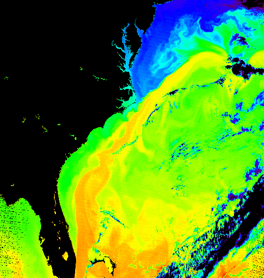
0 likes
-
Tampa Bay Hurricane

- Category 5
- Posts: 5597
- Age: 38
- Joined: Fri Jul 22, 2005 7:54 pm
- Location: St. Petersburg, FL
Re: Florida Weather Thread: Warm up in store! Near 80 possible
A/C back on this morning....9am temp in Fort Lauderdale is 75 with a dewpt of 63...feels a bit muggy compared to what it has been.
Another potent cold front to move through by the end of the week or start of the weekend....overall this appears to be different than last week's airmass in 2 ways: 1) duration of event and 2) magnitude of cold
Per NWS Miami Discussion this am:
THE PRIMARY THREAT FROM THIS FRONT WILL BE THE POSSIBILITY OF
ANOTHER FREEZE FOR THE AREAS NEAR LAKE OKEECHOBEE. MEX GUIDANCE
CONTINUES TO LOWER TEMPERATURES WITH EACH SUCCESSIVE RUN AND IS
NOW SHOWING MID 30S FOR GLADES AND HENDRY COUNTIES. THERE IS STILL
MUCH UNCERTAINTY ABOUT HOW COLD IT MIGHT ACTUALLY GET, BUT ALL
MODELS ARE SHOWING QUITE LOW 1000-850MB THICKNESSES AND A SURFACE
HIGH THAT WILL BE CENTERED ALONG THE CENTRAL GULF COAST BY 12Z
SATURDAY (ALTHOUGH THE ECMWF SHOWS IT FARTHER TO THE EAST THAN THE
GFS.) THAT BEING SAID, ALL PEOPLE SHOULD MONITOR THE CHANGING
FORECAST FOR TEMPERATURES AT LEAST APPROACHING THE FREEZING MARK
OVER THE NORTHERN COUNTIES.
THIS AIRMASS WILL NOT BE AS COLD AS
THE ONE THAT MOVED ACROSS THE REGION LAST WEEK AND IF A FREEZE
DOES OCCUR, IT WILL NOT BE AS WIDESPREAD NOR WILL TEMPERATURES
LIKELY LOWER INTO THE 20S.
0 likes
-
JonathanBelles
- Professional-Met
- Posts: 11430
- Age: 35
- Joined: Sat Dec 24, 2005 9:00 pm
- Location: School: Florida State University (Tallahassee, FL) Home: St. Petersburg, Florida
- Contact:
Re:
Front is a double-edged sword in some respects....here in south florida we have a 30% scattered rain chance followed by even drier air and winds to dry brush out.
FIRE WEATHER...NO PROBLEMS EXPECTED DURING THE SHORT TERM PERIOD. VERY
DRY AIR IS EXPECTED TO SPREAD SOUTH BEHIND THE COLD FRONT WITH DEW
POINT EXPECTED IN THE 30S TO 40S BY SAT AFTERNOON. THIS COULD
RESULT IN RH VALUES BELOW CRITICAL LEVELS SATURDAY WITH RH
GRADUALLY RECUPERATING AFTER THAT.
FIRE WEATHER...NO PROBLEMS EXPECTED DURING THE SHORT TERM PERIOD. VERY
DRY AIR IS EXPECTED TO SPREAD SOUTH BEHIND THE COLD FRONT WITH DEW
POINT EXPECTED IN THE 30S TO 40S BY SAT AFTERNOON. THIS COULD
RESULT IN RH VALUES BELOW CRITICAL LEVELS SATURDAY WITH RH
GRADUALLY RECUPERATING AFTER THAT.
fact789 wrote:I am really liking the forecast changes today. Now forecasting 60% TSTMs Thursday (we need the rain and a little activity), and now two cooler nights! Good timing not affecting the Super Bowl too!
0 likes


Re: Florida Weather Thread: Warm up in store! Near 80 possible
000
FXUS62 KJAX 271947
AFDJAX
AREA FORECAST DISCUSSION
NATIONAL WEATHER SERVICE JACKSONVILLE FL
246 PM EST TUE JAN 27 2009
FRIDAY...TRAILING SHORTWAVE WILL FINALLY KICK COLD FRONT WELL OFF TO
THE SOUTHEAST AND SLOWLY SHIFT RAIN SHIELD OUT OF THE FORECAST AREA.
CLEARING SKIES AND BRISK NWLY WINDS WILL STILL MAKE FOR RATHER COOL
DAY WITH MAX TEMPS IN THE 50S.
FRIDAY NIGHT...HIGH PRESSURE PUSHING INTO THE REGION AND VERY COLD
NWLY FLOW AT THE SURFACE AND ALOFT WILL MAKE FOR AN ADVECTIVE FREEZE
EVENT BY SATURDAY MORNING WITH MIN TEMPS IN THE 20S INLAND AND 30S
SOUTH AND EAST OF JACKSONVILLE ALONG THE I-95 CORRIDOR. NOT AS COLD
AS LAST EVENT BUT WILL STILL BE CLOSE TO A HARD FREEZE AND POSSIBLE
WIND CHILL ADVISORY CRITERIA.
.LONG TERM...SATURDAY THROUGH TUESDAY...
SATURDAY...SUNNY BUT VERY COLD DAY WITH MAX TEMPS STRUGGLING TO MAKE
IT INTO THE 50S. TEMPS WILL PLUMMET SAT NIGHT AS HIGH STACKS RIGHT
OVER THE FORECAST AREA WITH ANOTHER FREEZE/HARD FREEZE(?) EXPECTED
BY SUNDAY MORNING.
Nice cold snap the North Florida is used to.
MONDAY/TUESDAY...LOW CONFIDENCE THIS FAR OUT...BUT MODELS TRYING TO
DEVELOP FAST MOVING LOW PRESSURE SYSTEM TRACKING ACRS THE FORECAST
AREA. FOR NOW...HAVE GONE WITH JUST A 20-30% CHANCE OF SHOWERS AS
MODELS TRY TO GET A HANDLE ON EARLY NEXT WEEK EVENT.
0 likes
-
tropicana

- Category 5
- Posts: 8056
- Joined: Sat Sep 27, 2003 6:48 pm
- Location: Niagara Falls, Ontario, Canada
- Contact:
Re: Florida Weather Thread: Warm up in store! Near 80 possible
For today, Tue Jan 27, 2009...
Miami reached 80F....its warmest day since January 13.
Ft Lauderdale reached 80F... its warmest day since Jan 13 as well.
Tampa 81F barely missing the record of 82F... it has been the only 80F degree day all month.
Orlando also reached 80F... warmest day since YESTERDAY!
Key West didnt hit 80F today, or since January 13.
-justin-
0 likes
Return to “USA & Caribbean Weather”
Who is online
Users browsing this forum: TomballEd and 66 guests