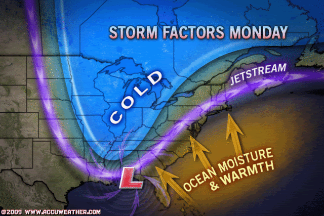
from noaa.gov discussion: THE MOST INTERESTING PERIOD OF THE EXTENDED FORECAST WILL BE TUESDAY
AND WEDNESDAY. ALTHOUGH THE TRACKS ARE QUITE A BIT DIFFERENT THE GFS
AND ECMWF BOTH DEEPEN THE GULF STATES LOW SIGNIFICANTLY AND MOVE IT
NORTHWARD ACROSS OUR CWA TUESDAY. THIS COULD RESULT IN A SIGNIFICANT
WEATHER EVENT. STAY TUNED.
The local mets are taking about a "Nor'easter" Can anyone look or post the model runs for this? Thank you!
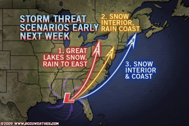
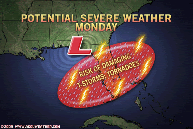
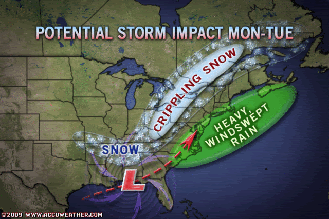
Possible Major East Coast Storm early next week
Moderator: S2k Moderators
Forum rules
 The posts in this forum are NOT official forecast and should not be used as such. They are just the opinion of the poster and may or may not be backed by sound meteorological data. They are NOT endorsed by any professional institution or STORM2K.

The posts in this forum are NOT official forecast and should not be used as such. They are just the opinion of the poster and may or may not be backed by sound meteorological data. They are NOT endorsed by any professional institution or STORM2K.
-
tracyswfla
- S2K Supporter

- Posts: 792
- Joined: Tue May 18, 2004 1:19 pm
- Location: Rochester, NY

-
tracyswfla
- S2K Supporter
- Posts: 792
- Joined: Tue May 18, 2004 1:19 pm
- Location: Rochester, NY

-
tracyswfla
- S2K Supporter
- Posts: 792
- Joined: Tue May 18, 2004 1:19 pm
- Location: Rochester, NY
-
Ed Mahmoud
JB and Tracy from SW Florida Winter Monster Storm?
Tracy's Upstate NY Winter Storm Thread
JB is talking the March 1993 Super-Storm (not that he is saying next week's storm would come close to matching that) and a 3 jet stream Grand Planetary Alignment.
JB suggests Euro may be a tad West this early on the Cousin of All Storms. But wow, 80 knot LLJ near NYC? Wow!


12Z Canadian is in the general ballpark...
Even the GFS looks way interesting.
It would be rain at this point on New York's Long Island, but 40 knot winds from the South, with a decent fetch, I see potential storm surge flooding issues with this!

JB is talking the March 1993 Super-Storm (not that he is saying next week's storm would come close to matching that) and a 3 jet stream Grand Planetary Alignment.
JB suggests Euro may be a tad West this early on the Cousin of All Storms. But wow, 80 knot LLJ near NYC? Wow!
12Z Canadian is in the general ballpark...
Even the GFS looks way interesting.
It would be rain at this point on New York's Long Island, but 40 knot winds from the South, with a decent fetch, I see potential storm surge flooding issues with this!
0 likes
-
Ed Mahmoud
Re: Upstate NY
tracyswfla wrote:Is there a thread anywhere else on this storm? It looks to be a monster!!!!
Funny you should ask...
http://www.storm2k.org/phpbb2/viewtopic.php?f=22&t=104572
0 likes
-
tracyswfla
- S2K Supporter
- Posts: 792
- Joined: Tue May 18, 2004 1:19 pm
- Location: Rochester, NY

-
Ed Mahmoud
Re: JB and Tracy from SW Florida Winter Monster Storm?
tracyswfla wrote:ok so are you saying I am
Fixing to have a monster winter storm?
Well, 5 to 6 days out, the details are cloudy.
BTW, I moved from Orlando, Florida 32813 to Saratoga Springs, NY in August 1984, and yes, Upstate is colder than Florida. But was Genesee Cream Ale readily available in Florida? But I digress. In January, 1985 I left Upstate New York for good, for the warmer climes of the North Arabian Sea.
Anyhow, checking my AccuWeather PPV MOS, even Albany sees more rain than snow at this point, but it would seem Joe seems to think from moring writing he expects shift in storm track farther East.
I should watch the JB videos and get his latest thinking...
0 likes

-
srainhoutx

- S2K Supporter
- Posts: 6919
- Age: 68
- Joined: Sun Jan 14, 2007 11:34 am
- Location: Haywood County, NC
- Contact:
Re: Upstate NY
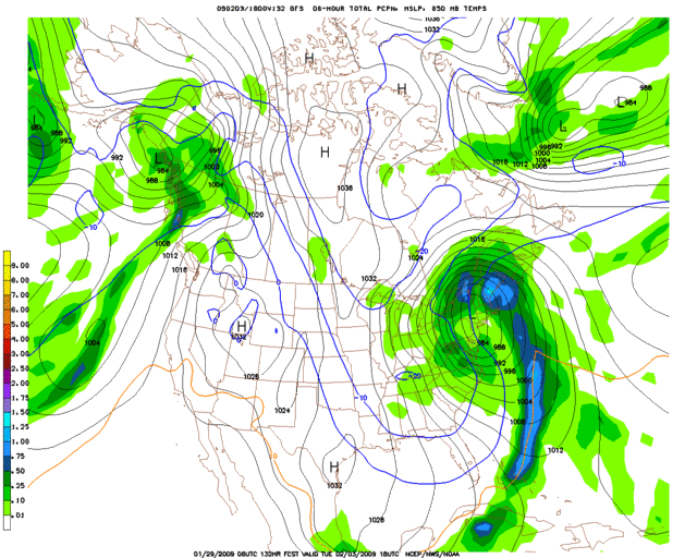
EXTENDED FORECAST DISCUSSION
NWS HYDROMETEOROLOGICAL PREDICTION CENTER CAMP SPRINGS MD
230 PM EST THU JAN 29 2009
VALID 12Z SUN FEB 01 2009 - 12Z THU FEB 05 2009
...FINAL MEDIUM RANGE DISCUSSION....
A MEAN UPPER LOW WILL CONTINUE TO MEANDER AROUND NORTHERN ALASKA
THIS PERIOD. TELECONNECTIONS ON THIS FEATURE FAVOR A TROUGH OFF
THE EAST COAST AND RIDGING FROM THE ROCKIES INTO THE WESTERN GREAT
LAKES. SYSTEMS SHOULD REMAIN GENERALLY PROGRESSIVE WITHIN THIS
FLOW REGIME...BUT SLOWER AND WITH WITH MUCH HIGHER AMPLITUDE THAN
SUGGESTED BY TELECONNECTIONS.
FINAL PROGS STAYED WITH THE UPDATED PRELIM 50-50 BLEND OF THE
06Z/29 GFS AMD THE 00Z/29 ECMWF. EARLIER...WE HAD CHOSEN THE
06Z/29 GFS OVER THE CORRESPONDING 00Z/29 GFS RUN BECAUSE IT
TRENDED FARTHER S TOWARDS THE ECMWF WITH A SYS OFF THE CA COAST
NEXT WED/THU DAYS 6-7. THIS GFS CONTINUITY CHANGE SEEMED
REASONABLE GIVEN THE HIGH AMPLITUDE OF THE OVERALL LARGE-SCALE
PATTERN...AND EFFECTIVELY DELAYS THE ONSET OF ANY PCPN FROM THIS
SYS REACHING CA.
SOME CANADIAN ENSEMBLE MEMBERS APPEAR TO BEGIN TO DEAMPLIFY THE
PATTERN TOO QUICKLY DAYS 6-7 AND WE ARE STICKING WITH HIGHER
AMPLITUDE GFS AND ECMWF ENSEMBLE MEMBERS AT THIS TIME. NEW 12Z
DETERMINISTIC MODELS ARE STAYING WITH THE HIGH AMPLITUDE GAME PLAN
AT LEAST THRU WED DAY 6...ALTHO THE 12Z GFS IS BEGINNING TO TREND
A BIT MORE PROGRESSIVE BY THU DAY 7.
THE BIG HEADLINE FOR THIS MEDIUM RANGE PERIOD CONTINUES TO BE THE
STRONG CYCLOGENESIS THAT SHOULD IGNITE SOMEWHERE VCNTY OF THE MS
DELTA EARLY MON DAY 4....THEN DEEPEN ON ITS NE TREK FROM THAT
POINT. WE HAVE ABOVE AVERAGE CONFIDENCE IN OUR FORECAST MANUAL
POSITION FOR THIS STORM OVER SE PA ON TUE DAY 5. THE HPC POSITION
IS ROUGHLY IN THE CENTER OF THE ENVELOPE OF 12Z DETERMINISTIC
MODEL SOLUTIONS DEFINED ON THE ERN EDGE BY THE GFS/CANADIAN...AND
ON THE SW EDGE BY THE THE ECMWF AND UKMET HIRES. THE CONSENSUS
TRACK IS STILL NEAR I-95 AS FAR N AS NYC...WITH THE 00Z/29
GFS/ECMWF ENSEMBLE MEANS FAVORING A BIT FARTHER E TRACK. WE STILL
EXPECT HEAVY RAINS ALONG THE TRACK OF THE LOW THRU THE COASTAL
PLAIN AND MODERATE TO HEAVY SNOWS TO THE LEFT OF THE TRACK IN THE
APPALACHIANS.ALL BUT FAR INTERIOR NEW ENG SHOULD BE MOSLTY RAIN.
MARGINAL INSTABILITY COULD SUPPORT CONVECTION EARLY TUE OVER ERN
NC AND THE SRN DELMARVA PENINSULA THANKS TO A STRONG LOW LEVEL JET
AND VIGOROUS UPPER DYNAMICS.
FLOOD
0 likes
-
srainhoutx
- S2K Supporter
- Posts: 6919
- Age: 68
- Joined: Sun Jan 14, 2007 11:34 am
- Location: Haywood County, NC
- Contact:
Re: Re:
Ed Mahmoud wrote:CajunMama wrote:Well, my first merge. If there's a topic already started there is no need to start a new thread.
I think the thread should be amended to reflect more than just Upstate New York. The whole reason I had started a second thread.
I agree with this. No hype intended, but this has all the makings of a "Historic Winter Weather Event". Terms that I personally do not throw around lightly. All one has to do is look at all the AFD's coming out from Birmingham to the Great Lakes and beyond to see the interest of local WFO's concerning this Miller A setup.
0 likes


-
Ed Mahmoud
Re: Upstate NY
I still think we should change the thread title to expand the scope, since this could be pretty big, even if mostly rain in the Big Cities.
BTW, this promised another freeze threat well into Florida per 18Z GFS...

Of course, a 978 mb low near ART is darned impressive, and that is Upstate...

BTW, this promised another freeze threat well into Florida per 18Z GFS...
Of course, a 978 mb low near ART is darned impressive, and that is Upstate...
0 likes
-
JonathanBelles
- Professional-Met

- Posts: 11430
- Age: 35
- Joined: Sat Dec 24, 2005 9:00 pm
- Location: School: Florida State University (Tallahassee, FL) Home: St. Petersburg, Florida
- Contact:

-
srainhoutx
- S2K Supporter
- Posts: 6919
- Age: 68
- Joined: Sun Jan 14, 2007 11:34 am
- Location: Haywood County, NC
- Contact:
Re: Possible Major East Coast Storm early next week
00Z's should be worth watching tonight. NAM was further W with upcoming event as well...
http://www.nco.ncep.noaa.gov/pmb/nwprod ... amer.shtml
http://www.nco.ncep.noaa.gov/pmb/nwprod ... amer.shtml
0 likes
-
tomboudreau

- Category 5

- Posts: 1869
- Age: 48
- Joined: Tue Feb 18, 2003 6:07 pm
- Location: Carnegie, PA
- Contact:
Re:
ohiostorm wrote:im so sick of this weather
Your not along with that statement. I think I head on the news tonight that 23 out of the 29 days this month have had a trace of snowfall so far this month. Enough is enough!
0 likes
Who is online
Users browsing this forum: No registered users and 233 guests