Southern Plains winter wx thread (2008-2009)

Winter Weather Discussion

Moderator: S2k Moderators

Forum rules

The posts in this forum are NOT official forecast and should not be used as such. They are just the opinion of the poster and may or may not be backed by sound meteorological data. They are NOT endorsed by any professional institution or STORM2K.

Help Support Storm2K
Message
Author
User avatar
somethingfunny
ChatStaff
ChatStaff
Posts: 3926
Age: 36
Joined: Thu May 31, 2007 10:30 pm
Location: McKinney, Texas

Re: Southern Plains winter storm thread

#1221 Postby somethingfunny » Tue Jan 27, 2009 9:10 pm

HOT DIGGITY!

I wish my cell phone's camera was working right now...I snapped off a piece of grass encased within about .2" of ice in each direction and placed it in my freezer for posterity. Couldn't get in my car's drivers side door but managed to get in through the passenger door (door was facing east) to get my flashlight. My dog is partially an Alaskan breed and I'm a native of New Jersey so we both had a great time running around in the crunchy grass exploring all the things coated with ice. :D

When I first stepped outside, there was a steady freezing rain falling, but about 5 minutes into our walk it began sleeting. Sleeting pretty hard.... :lol: We spent about 20 minutes out there...by the time I came in, my dog's leash had a glaze of ice on it. :eek:
0 likes   

arizonasooner

Re: Southern Plains winter storm thread

#1222 Postby arizonasooner » Tue Jan 27, 2009 10:26 pm

All in all, this was a pretty decent winter storm here in Tulsa after a questionable start.

Freezing drizzle started yesterday, was unimpressive until the overnight when it became heavier and mixed with sleet. We had about 1/2 inch of ice and 1/2 inch of sleet on top of it in the morning. Then, as the day went on, the sleet was pretty much non-stop and we ended up with about 3 inches of it in the street. Finally we got an inch or so of fluffy snow to top it all off this evening. Temps in the low 20s all day long, now about 19F.

Whoever called for an eastern OK storm about a week ago was dead on.
0 likes   

Ed Mahmoud

Re: Southern Plains winter storm thread

#1223 Postby Ed Mahmoud » Wed Jan 28, 2009 9:40 am

Not quite the Plains:


OK, with an onshore wind, Islip is up to 33ºF, and snow went to straight rain after 3 inches of accumulation. It will all wash away. Ditto JFK and Farmingdale.

But in New York City (NYC and LGA), 2 inches of snow has changed to freezing rain, 30ºF both stations, and .07 to .10 inches of liquid has fallen last hour. Temps are warming, but have been below freezing over 2 days straight, so you know that liquid is sticking solid when it hits.


So, I'd say the Southern State Parkway is the preferred route, and motorists getting a late start (9:30 NYC time already) should avoid the Northern State and LIE.


I have a feeling the usual valleys Northwest of NYC will be ugly this afternoon, even as NYC goes above freezing due to proximity to the Atlantic.
0 likes   

User avatar
Extremeweatherguy
Category 5
Category 5
Posts: 11095
Joined: Mon Oct 10, 2005 8:13 pm
Location: Florida

Re: Southern Plains winter storm thread

#1224 Postby Extremeweatherguy » Wed Jan 28, 2009 3:33 pm

Still lots of snow/sleet on the ground here in SE OKC this afternoon. Here is a video update I just recently shot: http://www.youtube.com/watch?v=oZkOSzr67-U
0 likes   

User avatar
Extremeweatherguy
Category 5
Category 5
Posts: 11095
Joined: Mon Oct 10, 2005 8:13 pm
Location: Florida

#1225 Postby Extremeweatherguy » Wed Jan 28, 2009 10:55 pm

Looks like freezing fog could be a concern tonight across Oklahoma...

Image
0 likes   

User avatar
gboudx
S2K Supporter
S2K Supporter
Posts: 4080
Joined: Thu Sep 04, 2003 1:39 pm
Location: Rockwall, Tx but from Harvey, La

Re: Southern Plains winter storm thread

#1226 Postby gboudx » Wed Jan 28, 2009 11:04 pm

Parts of DFW area too.
Last edited by gboudx on Thu Jan 29, 2009 4:57 pm, edited 1 time in total.
0 likes   

User avatar
somethingfunny
ChatStaff
ChatStaff
Posts: 3926
Age: 36
Joined: Thu May 31, 2007 10:30 pm
Location: McKinney, Texas

#1227 Postby somethingfunny » Thu Jan 29, 2009 4:52 am

Jeez. Everything's white again. Frost. :)
0 likes   

User avatar
Extremeweatherguy
Category 5
Category 5
Posts: 11095
Joined: Mon Oct 10, 2005 8:13 pm
Location: Florida

#1228 Postby Extremeweatherguy » Thu Jan 29, 2009 12:55 pm

I am quite surprised at how long this snow/sleet pack has remained. As of noon today, we still have a solid layer of white covering the ground up to 1-2" deep in many places. This now makes 3 days in a row of having a snow/sleet pack across the area, but an end does appear to be in sight. With temperatures warming into the 40s this afternoon, I suspect that a good deal of the ice/snow will melt.
0 likes   

User avatar
Extremeweatherguy
Category 5
Category 5
Posts: 11095
Joined: Mon Oct 10, 2005 8:13 pm
Location: Florida

#1229 Postby Extremeweatherguy » Fri Jan 30, 2009 4:28 pm

The CPC is showing above normal precipitation chances beginning in about 8-14 days...

http://www.cpc.noaa.gov/products/predic ... cp.new.gif

If any of this precipitation can mix with a shot of colder air, then things could once again get interesting for the southern Plains. Mid/late February might be a fun time down here! :)
0 likes   

User avatar
gboudx
S2K Supporter
S2K Supporter
Posts: 4080
Joined: Thu Sep 04, 2003 1:39 pm
Location: Rockwall, Tx but from Harvey, La

#1230 Postby gboudx » Fri Jan 30, 2009 4:42 pm

Well their 8-14 day Temp map show above normal too. I'll take it though if it means some rain.
0 likes   

User avatar
Extremeweatherguy
Category 5
Category 5
Posts: 11095
Joined: Mon Oct 10, 2005 8:13 pm
Location: Florida

Re:

#1231 Postby Extremeweatherguy » Fri Jan 30, 2009 5:09 pm

gboudx wrote:Well their 8-14 day Temp map show above normal too. I'll take it though if it means some rain.
Yeah, I guess it depends. The TX/OK region is kind of in the battle-ground zone between above and below normal temperatures, so I would assume that that means we could see some back and forth swings.

http://www.cpc.noaa.gov/products/predic ... .small.gif

Like you said though, even just rain would be nice. The southern Plains needs any precipitation it can get!
0 likes   

User avatar
cheezyWXguy
Category 5
Category 5
Posts: 6092
Joined: Mon Feb 13, 2006 12:29 am
Location: Dallas, TX

Re: Re:

#1232 Postby cheezyWXguy » Fri Jan 30, 2009 5:50 pm

Extremeweatherguy wrote:
gboudx wrote:Well their 8-14 day Temp map show above normal too. I'll take it though if it means some rain.
Yeah, I guess it depends. The TX/OK region is kind of in the battle-ground zone between above and below normal temperatures, so I would assume that that means we could see some back and forth swings.

http://www.cpc.noaa.gov/products/predic ... .small.gif

Like you said though, even just rain would be nice. The southern Plains needs any precipitation it can get!

Its showing alaska being way below normal tho, and that could mean another winter storm coming down in about 2 1/2 to 3 weeks
0 likes   

User avatar
Portastorm
Storm2k Moderator
Storm2k Moderator
Posts: 9914
Age: 62
Joined: Fri Jul 11, 2003 9:16 am
Location: Round Rock, TX
Contact:

Re: Southern Plains winter wx thread

#1233 Postby Portastorm » Mon Feb 02, 2009 9:50 am

Time is running out on this alleged Southern Plains winter. However, I'm optimistic that the last half of February will bring us some real action. For several days now the GFS is showing a big pattern shift with an active southern jet and deep, cold troughs progressively moving west to east. We have a tanking NAO to boot.

Lucy's not done yet boys and girls! :lol:
0 likes   

User avatar
srainhoutx
S2K Supporter
S2K Supporter
Posts: 6919
Age: 67
Joined: Sun Jan 14, 2007 11:34 am
Location: Haywood County, NC
Contact:

Re: Southern Plains winter wx thread

#1234 Postby srainhoutx » Mon Feb 02, 2009 5:11 pm

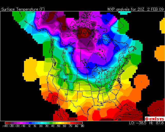
I'm still thinking that Mid February will offer a colder pattern in the S Plains States. As Portastorm mentioned, the Mid/Long Range guidance "hints" a more active pattern versus this persistant dry period we have seen over the past several month. We know that things can change on a dime around here very quickly. Let's hope so at least. Almost time for some Pre Spring pruning. There's a lot of cold air to our north, now how far south it makes it will be the key...

Image
0 likes   

User avatar
Extremeweatherguy
Category 5
Category 5
Posts: 11095
Joined: Mon Oct 10, 2005 8:13 pm
Location: Florida

Re: Southern Plains winter wx thread

#1235 Postby Extremeweatherguy » Thu Feb 05, 2009 1:34 pm

Joe Bastardi is really excited about the mid February through early March period. He thinks we will see lots of chilly and stormy weather for most of the southern and central part of the country during that timeframe, with the potential for some of the best winter events of the season in places such as the south/central plains and mid Atlantic states.

Fortunately, It looks like the CPC has the same general idea as well:

http://www.cpc.noaa.gov/products/predic ... mp.new.gif
http://www.cpc.noaa.gov/products/predic ... cp.new.gif

Could get interesting! :)
0 likes   

User avatar
srainhoutx
S2K Supporter
S2K Supporter
Posts: 6919
Age: 67
Joined: Sun Jan 14, 2007 11:34 am
Location: Haywood County, NC
Contact:

Re: Southern Plains winter wx thread

#1236 Postby srainhoutx » Thu Feb 05, 2009 2:52 pm

As is typical with these late winter/early spring events, severe weather often preclude the swing from warmth to a major cool down...

EXTENDED FORECAST DISCUSSION
NWS HYDROMETEOROLOGICAL PREDICTION CENTER CAMP SPRINGS MD
136 PM EST THU FEB 05 2009

VALID 12Z SUN FEB 08 2009 - 12Z THU FEB 12 2009

THE MODELS AND ENSEMBLES SHOW VERY GOOD CONTINUITY WITH THE LARGE
SCALE FLOW FORECAST BUT STILL OFFER SOME SOLUTION SPREAD AND RUN
TO RUN ADJUSTMENTS WITH INDIVIDUAL SYSTEMS.

A MEAN TROF OVER THE WRN CONUS AS PART OF A SPLIT FLOW REGIME
SHOULD DISPLAY A GRADUAL EWD DRIFT AND PERHAPS BROADEN A LITTLE
WITH TIME AS INDIVIDUAL SHRTWVS AMPLIFY INTO AND THEN EJECT OUT OF
THE MEAN TROF. WITH THE TROF/UPPER LOW FCST TO BE OVER THE
SOUTHWEST AS OF DAY 3 SUN... THE 00Z GFS MAY BE A LITTLE TOO FAST
WITH LEADING HEIGHT FALLS BUT IS WELL WITHIN THE MODEL/ENSEMBLE
SPREAD AND CLOSE TO THE ECMWF WITH ASSOCIATED LOW PRESSURE THAT
SHOULD REACH THE VICINITY OF MN BY DAY 5 TUE. THERE IS BETTER
THAN AVERAGE CLUSTERING OF SOLUTIONS WITH THE NEXT AMPLIFYING
SHORTWAVE SCHEDULED TO ENTER THE WEST ON MON. HOWEVER BY
TUE-WED...THE 00 AND 06Z GFS RUNS ARE IN THE QUICKER THIRD OF THE
SOLUTION SPECTRUM AS THIS ENERGY REACHES THE PLAINS. GFS
SOLUTIONS BRINGING MORE ENERGY INTO A DOWNSTREAM RIDGE THAN MOST
OTHER MODEL/ENSEMBLE GUIDANCE TEND NOT TO WORK OUT WELL SO PREFER
TO LEAN SLOWER THAN THE 00/06 GFS RUNS FOR THIS SYSTEM. THIS IS
ALSO SUPPORTED IN THAT THE 12Z GFS AND EVEN THE 12 UTC ECMWF HAVE
NOW TRENDED SLOWER THAN THEIR RESPECTIVE 00 UTC RUNS.
UPSTREAM...THE NEXT SHORTWAVE IN THE SERIES SHOULD REACH THE WEST
COAST AROUND TUE NIGHT/WED. BEST CLUSTERING OF OPERATIONAL MODELS
ALONG WITH THE 00Z GEFS AND 00Z ECMWF/CANADIAN ENSEMBLES FAVOR A
SHORTWAVE TROF THAT IS FASTER AND MORE NEUTRALLY TILTED THAN THE
SLOW/POSITIVELY TILTED GFS.

HPC DAYS 3-4 SUN-MON PROGS CONTINUE TO BE MAINLY DERIVED FROM A
00Z GFS/ECMWF BLEND WEIGHTED MORE TOWARD THE ECMWF TO ACCOUNT FOR
PREFERENCES WITH A LEADING SYSTEM HEADING INTO THE PLAINS. DAYS
5-7 TUE-THU EMPLOY A BLEND OF HALF 00Z ECMWF AND THE REMAINDER 00Z
GEFS/00Z ECMWF ENSEMBLE MEAN TO REFLECT CONSENSUS THAT IS SLOWER
THAN THE GFS WITH THE TRAILING SYSTEM EMERGING INTO THE PLAINS BY
WED AND FASTER/MORE NEUTRALLY TILTED THAN THE GFS WITH ENERGY
AMPLIFYING INTO THE WEST NEXT WED-THU. THIS PATTERN HIGHLIGHTS A
SERIES OF AMPLIFIED AND PROGRESSIVE SYSTEMS THAT WILL FOCUS
DYNAMICALLY DRIVEN AND WIDESPREAD WINTER PRECIPITATION POTENTIAL
FROM THE WRN/SWRN US ENEWD OUT ACROSS THE ROCKIES AND
PLAINS
...INCLUDING A LEAD SEVERE WEATHER THREAT.

RAUSCH/SCHICHTEL
0 likes   

User avatar
iorange55
Category 5
Category 5
Posts: 2388
Joined: Thu Nov 13, 2008 9:47 pm
Location: Big D

Re: Southern Plains winter wx thread

#1237 Postby iorange55 » Fri Feb 06, 2009 2:16 am

Woah looking at the gfs model and reading all this has got me really excited. hopefully it all comes together for SNOW. not ice.
0 likes   

User avatar
Portastorm
Storm2k Moderator
Storm2k Moderator
Posts: 9914
Age: 62
Joined: Fri Jul 11, 2003 9:16 am
Location: Round Rock, TX
Contact:

Re: Southern Plains winter wx thread

#1238 Postby Portastorm » Fri Feb 06, 2009 6:52 am

Yep, the 0z GFS is showing not one but two snow/ice events for mainly north/west Texas after Valentines Day.
0 likes   

Ed Mahmoud

Re: Southern Plains winter wx thread

#1239 Postby Ed Mahmoud » Mon Feb 23, 2009 2:56 pm

One Last (relatively minor) Shot of Winter Joy for Extreme Weather Guy?


Image

Canadian has the cold air, but not the precip in phase.

GFS 2 meter temps look a tad warm for that inch of snow, but 850 mb temps and 1000-500 mb thicknesses are on EWG's side.
0 likes   

User avatar
Extremeweatherguy
Category 5
Category 5
Posts: 11095
Joined: Mon Oct 10, 2005 8:13 pm
Location: Florida

Re: Southern Plains winter wx thread

#1240 Postby Extremeweatherguy » Mon Feb 23, 2009 4:38 pm

I saw that too Ed. Looks interesting. It would definitely be nice if we could get one last shot of winter weather through here before Spring.
0 likes   


Return to “Winter Weather”

Who is online

Users browsing this forum: No registered users and 59 guests