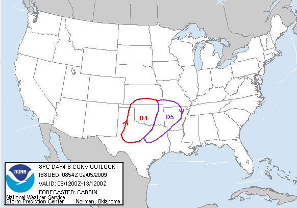
The SPC has already highlighted this area. February 9 looks to be the worst day.
ZCZC SPCSWOD48 ALL
ACUS48 KWNS 040913
SPC AC 040913
DAY 4-8 CONVECTIVE OUTLOOK
NWS STORM PREDICTION CENTER NORMAN OK
0313 AM CST WED FEB 04 2009
VALID 071200Z - 121200Z
...ACTIVE SEVERE WEATHER PATTERN FORECAST OVER AREAS OF THE
SOUTHERN/CENTRAL U.S. NEXT WEEK...
...DAY5/SUNDAY TO MONDAY MORNING...
MREF AND RECENT GFS RUNS CONTINUE TO EXHIBIT GOOD RUN-TO-RUN
CONSISTENCY IN THE DEVELOPMENT OF A VIGOROUS SHORT WAVE TROUGH
EJECTING NEWD FROM AZ TO THE SRN/CNTRL PLAINS SUNDAY INTO MONDAY.
ECMWF CONTINUES TO BE TYPICALLY SLOWER THAN THE GFS WITH THE TROUGH
POSITION THROUGH 120 HOURS/SUNDAY EVENING. BUT...RECENT ECMWF RUNS
HAVE BEEN TRENDING TOWARD A MORE PROGRESSIVE/EWD H5 TROUGH POSITION
NOW IN CLOSE AGREEMENT WITH THE MREF H5 MEAN. THIS LENDS CONFIDENCE
IN THE SYNOPTIC PATTERN BEING FORECAST ACROSS THE SRN PLAINS BY
SUNDAY EVENING.
GIVEN PRONOUNCED LARGE SCALE JET COUPLING AND STRENGTHENING ASCENT
DEVELOPING ACROSS TX/OK/KS THROUGH SUNDAY...DYNAMIC AND KINEMATIC
ENVIRONMENT SHOULD INCREASINGLY SUPPORT THE DEVELOPMENT OF SEVERE
STORMS WITH HAIL AND HIGH WINDS. AIR MASS QUALITY WILL OBVIOUSLY
PLAY A ROLE IN OVERALL SEVERE STORM COVERAGE AND MODE. NUMEROUS
RECENT INTRUSIONS OF COLD/DRY AIR INTO THE NW GULF SUGGEST THAT
MOISTURE RETURN AND RESULTANT CAPE WITH THIS UPCOMING SYSTEM WILL
LIKELY BE LIMITED. HOWEVER...THIS LIMITING FACTOR SHOULD BE SOMEWHAT
OFFSET BY THE MAGNITUDE OF FORCING AND SHEAR FORECAST TO ACCOMPANY
THE UPPER TROUGH...SURFACE LOW...AND FRONT MOVING OVER THE REGION
THROUGH SUNDAY NIGHT/MONDAY MORNING.
...DAY6/MONDAY TO TUESDAY MORNING...
PRIMARY MID/UPPER LEVEL DISTURBANCE/VORT MAX AND SURFACE LOW ARE
FORECAST TO LIFT NWD/NEWD TO THE UPPER MS VALLEY THROUGH EARLY
TUESDAY. IT APPEARS POSSIBLE THAT SEVERE STORMS...POSSIBLY TAKING
THE FORM OF A SQUALL LINE...MAY SPILL OVER FROM SUNDAY INTO MONDAY
FROM THE OZARKS TO ARKLATEX. OR...STORMS MAY REDEVELOP ALONG THIS
AXIS DURING THE DAY. THIS ACTIVITY MAY STRENGTHEN DURING THE DAY
WITHIN CONFLUENT WARM CONVEYOR BELT WHERE DEEP-LAYER SHEAR SHOULD BE
MORE THAN ADEQUATE FOR ORGANIZED/PERSISTENT UPDRAFTS/SUPERCELLS.
...DAY7-8/THROUGH MIDWEEK...
LARGE SCALE PATTERN IS FORECAST TO REMAIN QUITE ACTIVE/DYNAMIC WITH
GFS AND ECMWF BOTH FORECASTING ANOTHER DEEP TROUGH DEVELOPING OVER
THE PLAINS ON WEDNESDAY/DAY8. HOWEVER...IN THE WAKE OF POTENTIALLY
WIDESPREAD CONVECTION ACROSS THIS REGION ON PRIOR DAYS...SEVERE
STORM PREDICTABILITY AT THIS FORECAST RANGE IS LOW.
..CARBIN.. 02/04/2009
CLICK TO GET WUUS48 PTSD48 PRODUCT
Tornado outbreak - February 10-11, 8+ dead
Moderator: S2k Moderators
Forum rules

The posts in this forum are NOT official forecast and should not be used as such. They are just the opinion of the poster and may or may not be backed by sound meteorological data. They are NOT endorsed by any professional institution or STORM2K.
-
CrazyC83
- Professional-Met

- Posts: 34315
- Joined: Tue Mar 07, 2006 11:57 pm
- Location: Deep South, for the first time!
Tornado outbreak - February 10-11, 8+ dead
Last edited by CrazyC83 on Wed Feb 11, 2009 10:20 am, edited 5 times in total.
0 likes
-
Ed Mahmoud
Re: Severe weather returns? February 8-10
40 knot LLJ Sunday afternoon:

Looks like best divergence/shear over Central Plains:

Euro humidity fields suggest there could be enough moisture/warmth for storms, in the Southern-Central Plains (OK and KS, maybe)

Euro sees stronger LLJ into the Mid Mississippi Valley Monday afternoon.

The directional shear between 850 and 500 mb seems less, but the 500 mb flow looks to be stronger/faster.

Moisture return looks favorable, although 850 mb temps looks somewhat cool

I think a lot will depend on whether there are enough breaks in the clouds to allow the not-super high angle February sun to warm the surface.
Still early, both in the season and in reference to the event, but it is something to watch.
Looks like best divergence/shear over Central Plains:
Euro humidity fields suggest there could be enough moisture/warmth for storms, in the Southern-Central Plains (OK and KS, maybe)
Euro sees stronger LLJ into the Mid Mississippi Valley Monday afternoon.
The directional shear between 850 and 500 mb seems less, but the 500 mb flow looks to be stronger/faster.
Moisture return looks favorable, although 850 mb temps looks somewhat cool
I think a lot will depend on whether there are enough breaks in the clouds to allow the not-super high angle February sun to warm the surface.
Still early, both in the season and in reference to the event, but it is something to watch.
0 likes
-
Shockwave
- Tropical Storm

- Posts: 167
- Joined: Fri Jul 25, 2008 7:33 am
- Location: Lafayette, TN
- Contact:
Re: Severe weather returns? February 8-10
We are watching it closely here in TN for a few reasons that many here know why. If that low treks around the Central MO into IL track...we are in the line to get some rough weather. But if the track continues on up into IA or WI, maybe a squall line type event with wind and hail, but nothing in the way of supercell potential.
0 likes
-
Weatherfreak14

- Category 5

- Posts: 1381
- Joined: Sat Sep 24, 2005 3:40 pm
- Location: Beaufort, SC
- Contact:
Re: Severe weather returns? February 8-10
Looks like it could extend into the SE looking at the 18Z GFS model runs.... Could get quite interesting.
0 likes
-
srainhoutx

- S2K Supporter

- Posts: 6919
- Age: 68
- Joined: Sun Jan 14, 2007 11:34 am
- Location: Haywood County, NC
- Contact:
Re: Severe weather returns? February 8-12
It does look as if things are about to get very active as a trough digs out W ejecting an number of storm systems.
0 likes
-
Ed Mahmoud
Re: Severe weather returns? February 8-12
12Z Euro's big severe looks like Wednesday and Thursday, beyond the range SPC feels comfortable assigning a risk.


Mid-Miss Valley Wednesday afternoon, just getting into the Ohio Valley here just after sun-up, and probably well into the Ohio Valley by max heating. Even at sun-up, looks like the warm sector, with decent relative humidities and 850 mb temps above 50ºF are close to being co-existent with a near 60 knot LLJ.
The Tennessee mention above may be prescient.
0 likes
-
srainhoutx
- S2K Supporter
- Posts: 6919
- Age: 68
- Joined: Sun Jan 14, 2007 11:34 am
- Location: Haywood County, NC
- Contact:
Re:
CrazyC83 wrote:I agree, I don't think Sunday/Monday will be that big at this point. I sense it just being a prelude - similar to, say, the Monday afternoon system (just isolated wind/hail) ahead of the Super Tuesday outbreak.
I agree as well. The second system should track bit further S and low level jet looks to be quite strong behind it as well. Next week looks to be very interesting for severe weather trackers. I hope we don't see a repeat of last years Super Tuesday Outbreak, but the concern is growing for a widespread event before a major cool down across the CONUS.
0 likes
-
Ed Mahmoud
Re: Severe weather returns? February 8-12
Snip of FWD AFD- although how a week out they can be sure the models are right on the event occuring at a time other than near peak heating, is beyond me.
SURFACE WINDS WILL REMAIN SOUTHERLY AS ANOTHER SYSTEM DIPS INTO
THE FOUR CORNERS REGION QUICKLY ON THE HEELS OF THE FIRST ONE. THE
GFS IS FASTER AND STRONGER WITH THIS CYCLONE THAN THE ECMWF...
PORTRAYING A NEGATIVELY-TILTED CLOSED LOW PASSING THROUGH NORTH
TEXAS WEDNESDAY. LARGE-SCALE ASCENT AND ELEVATED INSTABILITY WILL
SUPPORT WIDESPREAD SHOWERS AND THUNDERSTORMS.
A FEW CLUES INDICATE THIS COULD BE A SIGNIFICANT WEATHER EVENT
EVEN THOUGH MUCH OF IT MAY OCCUR DURING THE NIGHT. STRONG UPPER
LEVEL DIVERGENCE IS NOTED ALONG A 130KT JET MAX WHICH WILL BE
POISED OVER NORTH TEXAS...HELPING TO BOLSTER SEVERE WEATHER
CHANCES WEDNESDAY NIGHT. BOTH THE GFS AND ECMWF DEPICT A SURFACE
LOW DEEPENING OVER OKLAHOMA DURING THIS TIME WITH AMPLE MOISTURE
IN PLACE. HAIL AND DAMAGING WINDS WILL MOST LIKELY BE A CONCERN AS
THIS EVENT UNFOLDS INTO DAY 8. SH/13
0 likes
-
CrazyC83
- Professional-Met
- Posts: 34315
- Joined: Tue Mar 07, 2006 11:57 pm
- Location: Deep South, for the first time!
Re: Severe weather returns? February 8-12
Based on what I can see:
Sunday (Feb. 8) - Not much. Some storms in the southern Plains, but I can't see anything widespread. Shear too low and instability also low. Probably no more than a low-end slight risk day.
Monday (Feb. 9) - The shear will be there but the instability may not be. Tornadoes possible in the Mississippi Valley but nothing compared to what lies ahead.
Tuesday (Feb. 10) - The break in the action. Nothing major. Some storms perhaps in the Plains and Midwest though. The timing could be critical though to determine what happens next...
Wednesday (Feb. 11) - This may be the huge outbreak, with the potential of rivaling February 5, 2008. From what I can see, everything looks just as conducive for extremely bad storms as they did that day. Shear and helicity could reach insane levels and instability increases with high dewpoints all around. A pre-frontal squall line could be the difference though. Primary area should be from Louisiana through to Indiana.
Thursday (Feb. 12) - The activity moves east, and the Mid-Atlantic into the Carolinas may be the target. However, the timing may not be as favorable as they would be getting it fairly early in the day with less instability despite the high shear
0 likes
-
Ed Mahmoud
Re: Severe weather returns? February 8-12
SPC has a Slight Risk area in West Texas for Sunday, and no area outlined Days 4-8 due to model variability. The first system, per SPC Day 3 and 4-8 discos, has limited moisture due to repeated cold front intrusions into the Gulf. But the one after will have had plenty of time for moisture recovery.
Looking at Euro, lead system may take some severe into the Central Mississippi Valley, but a second system mid to late week is the real severe weather threat. Mississippi to Ohio Valley, maybe points South. The day before, I'm hoping Texas gets some much needed rain. Valentine's Weekend may have more interesting weather, but not getting excited just yet.


Operational 0Z GFS doesn't look wildly different at 144 hours from Euro, instability somewhat limited, but favorable looking winds.

Edit to add- previous day (Tuesday) per same GFS has somewhat weaker wind fields, but good instability for this time of year in North Central Texas.

Looking at Euro, lead system may take some severe into the Central Mississippi Valley, but a second system mid to late week is the real severe weather threat. Mississippi to Ohio Valley, maybe points South. The day before, I'm hoping Texas gets some much needed rain. Valentine's Weekend may have more interesting weather, but not getting excited just yet.
Operational 0Z GFS doesn't look wildly different at 144 hours from Euro, instability somewhat limited, but favorable looking winds.
Edit to add- previous day (Tuesday) per same GFS has somewhat weaker wind fields, but good instability for this time of year in North Central Texas.
0 likes
-
srainhoutx
- S2K Supporter
- Posts: 6919
- Age: 68
- Joined: Sun Jan 14, 2007 11:34 am
- Location: Haywood County, NC
- Contact:
Re: Severe weather returns? February 8-12
I like to look toward Southern CA for "clues" concerning severe weather in the Plains and points N and E. This mornings SWS from San Diego offer some "hints" concerning the "strength" of the storms that will eject into the Plains later this weekend into next week. 
SPECIAL WEATHER STATEMENT
NATIONAL WEATHER SERVICE SAN DIEGO CA
545 AM PST FRI FEB 6 2009
CAZ042-043-048-050-055>058-060>062-062100-
ORANGE COUNTY COASTAL AREAS-SAN DIEGO COUNTY COASTAL AREAS-
SAN BERNARDINO AND RIVERSIDE COUNTY VALLEYS-THE INLAND EMPIRE-
SAN DIEGO COUNTY VALLEYS-SAN BERNARDINO COUNTY MOUNTAINS-
RIVERSIDE COUNTY MOUNTAINS-SANTA ANA MOUNTAINS AND FOOTHILLS-
SAN DIEGO COUNTY MOUNTAINS-APPLE AND LUCERNE VALLEYS-
COACHELLA VALLEY-SAN DIEGO COUNTY DESERTS-
545 AM PST FRI FEB 6 2009
...UNSETTLED WEATHER PATTERN THROUGH TUESDAY...
A SERIES OF UPPER LEVEL LOW PRESSURE SYSTEMS WILL MOVE ACROSS
SOUTHWEST CALIFORNIA TODAY THROUGH TUESDAY. THIS WILL BRING COOL
WEATHER WITH PERIODS OF SHOWERS AND POSSIBLE THUNDERSTORMS. THERE
WILL ALSO BE SNOW AT THE HIGHER ELEVATIONS...ESPECIALLY TONIGHT AND
SATURDAY.
MOIST WESTERLY FLOW ASSOCIATED WITH THE UPPER LOW WILL CONTINUE TO
BRING SCATTERED LIGHT TO MODERATE SHOWERS DURING THE DAY.
THE SECOND SYSTEM IS EXPECTED TO APPROACH THE AREA THIS AFTERNOON.
COLDER AIR ALOFT WILL CAUSE UNSTABLE CONDITIONS OVER THE COASTAL
WATERS AND NEAR THE COAST. THE UNSTABLE CONDITIONS MAY CAUSE BRIEF
HEAVY SHOWERS...THUNDERSTORMS...FUNNEL CLOUDS AND WATERSPOUTS.
SOUTHERLY WINDS AHEAD OF THIS SECOND SYSTEM COULD GENERATE HEAVY
PRECIPITATION ALONG THE COASTAL SLOPES OF THE MOUNTAINS...ESPECIALLY
IN SAN BERNARDINO COUNTY FRIDAY AFTERNOON AND CONTINUING INTO
SATURDAY.
RAINFALL AMOUNTS WITH THIS SECOND FRONT ARE FORECAST TO RANGE FROM
ABOUT TWO THIRDS OF AN INCH AT THE COAST TO OVER TWO INCHES ON THE
COASTAL SLOPES AND AROUND A QUARTER INCH IN THE DESERTS. THE SNOW
LEVEL IS EXPECTED TO LOWER TO AROUND 4500 FEET SATURDAY MORNING.
ELEVATIONS BETWEEN 4500 AND 5550 FEET SHOULD GET ABOUT 1 TO 2 INCHES
OF SNOW BY SATURDAY MORNING. ABOVE 5500 FEET...IN THE MOUNTAINS OF
RIVERSIDE AND SAN DIEGO COUNTY...SNOWFALL AMOUNTS BETWEEN 2 AND 6
INCHES ARE FORECAST FOR LATE TONIGHT THROUGH SATURDAY. THE HEAVIEST
SNOW FALL IS FORECAST IN THE SAN BERNARDINO MOUNTAINS....WHERE
ELEVATIONS ABOVE 7000 FEET COULD RECEIVE ADDITIONAL SNOW AMOUNTS
BETWEEN 10 AND 18 INCHES FRIDAY NIGHT THROUGH SATURDAY.
PRECIPITATION SHOULD MOSTLY END SUNDAY AS HIGH PRESSURE BUILDS OVER
THE AREA. A THIRD SYSTEM IS EXPECTED TO BRING MORE SHOWERS MONDAY
INTO TUESDAY.
THE RAIN WILL MAKE ROADS SLICK AND MOTORISTS SHOULD USE EXTRA
CAUTION. SNOW...BLOWING SNOW AND DENSE FOG IN THE MOUNTAINS COULD
MAKE TRAVEL HAZARDOUS...ESPECIALLY FRIDAY NIGHT THROUGH SATURDAY. IN
ADDITION HEAVY RAINFALL WILL LIKELY FILL NORMALLY DRY CREEKS AND
STREAMS AND MAY LEAD TO MUD SLIDES AND DISLODGE ROCKS IN RECENTLY
BURNED AREAS AND STEEP TERRAIN. PEOPLE LIVING IN OR PLANNING TRAVEL
THROUGH THROUGH THESE AREAS...OR ARE PLANNING OUTDOOR ACTIVITIES
NEXT TUESDAY SHOULD STAY INFORMED ON THIS UNSETTLED WEATHER PATTERN.
0 likes
-
Ed Mahmoud
Re: Severe weather returns? February 8-12
Reminds me of a Joe Bastardi rule of thumb- colder than normal weather in New York and rain in SoCal usually means a winter storm is on the way for the East Coast.
JB's AccuWx compatriot, Henry Margusity (sp?) IIRC, has stated something similar to your post above, any thunder/lightning at all with a system in coastal California is a strong signal for severe weather in the Plains a couple of days later.
0 likes
-
srainhoutx
- S2K Supporter
- Posts: 6919
- Age: 68
- Joined: Sun Jan 14, 2007 11:34 am
- Location: Haywood County, NC
- Contact:
Re: Severe weather returns? February 8-12
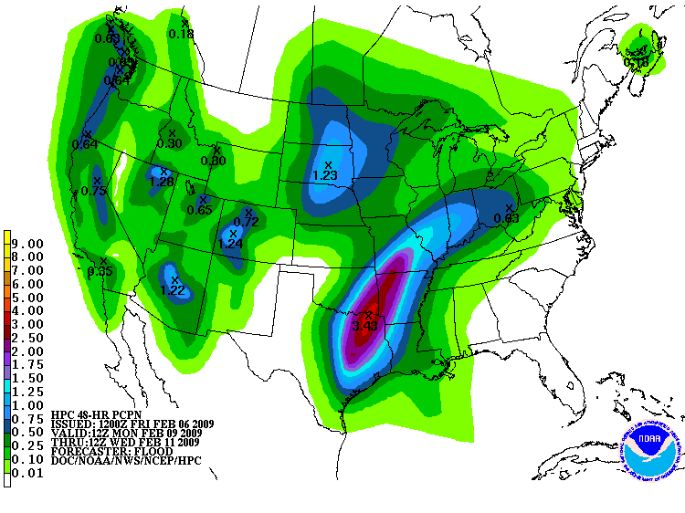
HPC is suggesting some healthy rainfall totals for the Eastern half of TX, SE OK, SW AR, MO, and NW LA early next week...
0 likes
-
vbhoutex

- Storm2k Executive

- Posts: 29149
- Age: 74
- Joined: Wed Oct 09, 2002 11:31 pm
- Location: Cypress, TX
- Contact:
Re: Severe weather returns? February 8-12
I sure hope that is right on the amounts. Lots of Texans will be very happy.
0 likes
-
srainhoutx
- S2K Supporter
- Posts: 6919
- Age: 68
- Joined: Sun Jan 14, 2007 11:34 am
- Location: Haywood County, NC
- Contact:
Re: Severe weather returns? February 8-12
vbhoutex wrote:I sure hope that is right on the amounts. Lots of Texans will be very happy.
Let's hope so vbhoutex...
0 likes
-
Ed Mahmoud
Re: Severe weather returns? February 8-12
Tuesday late afternoon per GFS just East of I-35 corridor extreme Southern Oklahoma, NE Texas, and into the Arklatex.

Longview 6 pm GFS sounding
instability a tad limited lowest 5000 feet or so, but decent mid-level instability, and fairly stout helicity numbers...

Early morning Memphis, again, quite limited instability, especially near surface, but low cloud bases and extreme helicity, and wind fields suggest even "garden variety" t-storms would be capable of severe wind gusts.

Longview 6 pm GFS sounding
instability a tad limited lowest 5000 feet or so, but decent mid-level instability, and fairly stout helicity numbers...
Early morning Memphis, again, quite limited instability, especially near surface, but low cloud bases and extreme helicity, and wind fields suggest even "garden variety" t-storms would be capable of severe wind gusts.
0 likes
Return to “USA & Caribbean Weather”
Who is online
Users browsing this forum: Majestic-12 [Bot], Stratton23 and 113 guests