

AXAU21 ABRF 051258
IDQ20018
TROPICAL CYCLONE TECHNICAL BULLETIN: AUSTRALIA - EASTERN REGION
Issued by BRISBANE TROPICAL CYCLONE WARNING CENTRE
at: 1258 UTC 05/03/2009
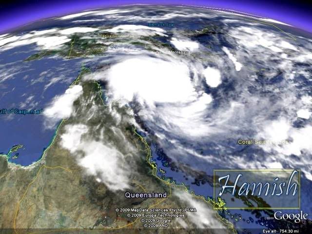
Name: Tropical Cyclone Hamish
Identifier: 17U
Data At: 1200 UTC
Latitude: 13.4S
Longitude: 147.0E
Location Accuracy: within 25 nm [46 km]
Movement Towards: south southwest [194 deg]
Speed of Movement: 4 knots [8 km/h]
Maximum 10-Minute Wind: 35 knots [65 km/h]
Maximum 3-Second Wind Gust: 50 knots [95 km/h]
Central Pressure: 997 hPa
Radius of 34-knot winds NE quadrant: 90 nm [165 km]
Radius of 34-knot winds SE quadrant: 90 nm [165 km]
Radius of 34-knot winds SW quadrant: 90 nm [165 km]
Radius of 34-knot winds NW quadrant: 90 nm [165 km]
Radius of 48-knot winds NE quadrant:
Radius of 48-knot winds SE quadrant:
Radius of 48-knot winds SW quadrant:
Radius of 48-knot winds NW quadrant:
Radius of 64-knot winds:
Radius of Maximum Winds: 25 nm
Dvorak Intensity Code: T3.0/3.0/D1.5/24HRS
Pressure of outermost isobar: 1006 hPa
Radius of outermost closed isobar: 140 nm [260 km]
Storm Depth: Medium
FORECAST DATA
Date/Time : Location : Loc. Accuracy: Max Wind : Central Pressure
[UTC] : degrees : nm [km]: knots[km/h]: hPa
+12: 06/0000: 14.3S 146.5E: 060 [110]: 040 [075]: 993
+24: 06/1200: 15.7S 147.0E: 080 [145]: 050 [095]: 987
+36: 07/0000: 16.9S 147.2E: 115 [215]: 060 [110]: 980
+48: 07/1200: 17.8S 147.9E: 125 [230]: 060 [110]: 979
+60: 08/0000: 18.9S 148.2E: 155 [285]: 060 [110]: 976
+72: 08/1200: 20.5S 149.6E: 195 [365]: 060 [110]: 976
REMARKS:
Descending QuikScat pass shows 35 to 40 knot winds in three quadrants. Deep
convection wraps 0.60 on log10 spiral. DT is 3.0. MET supports. System is
expected to continue to intensify under weak shear.
Copyright Commonwealth of Australia
==
The next bulletin for this system will be issued by: 05/1900 UTC by Brisbane
TCWC.
Coral Sea: HAMISH - Tropical Cyclone
Moderator: S2k Moderators
-
HURAKAN

- Professional-Met

- Posts: 46084
- Age: 39
- Joined: Thu May 20, 2004 4:34 pm
- Location: Key West, FL
- Contact:
Re: Coral Sea: HAMISH - Tropical Cyclone


WTPS31 PGTW 051500
SUBJ: TROPICAL CYCLONE 18P (HAMISH) WARNING NR 001
REF/A/NAVMARFCSTCEN/050921Z MAR 09//
AMPN/TROPICAL CYCLONE FORMATION ALERT//
1. TROPICAL CYCLONE 18P (HAMISH) WARNING NR 001
01 ACTIVE TROPICAL CYCLONE IN SOUTHPAC
MAX SUSTAINED WINDS BASED ON ONE-MINUTE AVERAGE
---
WARNING POSITION:
051200Z --- NEAR 13.7S 146.9E
MOVEMENT PAST SIX HOURS - 220 DEGREES AT 06 KTS
POSITION ACCURATE TO WITHIN 060 NM
POSITION BASED ON CENTER LOCATED BY SATELLITE
PRESENT WIND DISTRIBUTION:
MAX SUSTAINED WINDS - 030 KT, GUSTS 040 KT
WIND RADII VALID OVER OPEN WATER ONLY
REPEAT POSIT: 13.7S 146.9E
---
FORECASTS:
12 HRS, VALID AT:
060000Z --- 14.7S 146.9E
MAX SUSTAINED WINDS - 040 KT, GUSTS 050 KT
WIND RADII VALID OVER OPEN WATER ONLY
RADIUS OF 034 KT WINDS - 085 NM NORTHEAST QUADRANT
085 NM SOUTHEAST QUADRANT
075 NM SOUTHWEST QUADRANT
075 NM NORTHWEST QUADRANT
VECTOR TO 24 HR POSIT: 175 DEG/ 06 KTS
---
24 HRS, VALID AT:
061200Z --- 15.9S 147.0E
MAX SUSTAINED WINDS - 050 KT, GUSTS 065 KT
WIND RADII VALID OVER OPEN WATER ONLY
RADIUS OF 034 KT WINDS - 090 NM NORTHEAST QUADRANT
090 NM SOUTHEAST QUADRANT
080 NM SOUTHWEST QUADRANT
080 NM NORTHWEST QUADRANT
VECTOR TO 36 HR POSIT: 160 DEG/ 08 KTS
---
36 HRS, VALID AT:
070000Z --- 17.4S 147.6E
MAX SUSTAINED WINDS - 060 KT, GUSTS 075 KT
WIND RADII VALID OVER OPEN WATER ONLY
RADIUS OF 050 KT WINDS - 045 NM NORTHEAST QUADRANT
045 NM SOUTHEAST QUADRANT
040 NM SOUTHWEST QUADRANT
040 NM NORTHWEST QUADRANT
RADIUS OF 034 KT WINDS - 095 NM NORTHEAST QUADRANT
095 NM SOUTHEAST QUADRANT
085 NM SOUTHWEST QUADRANT
085 NM NORTHWEST QUADRANT
VECTOR TO 48 HR POSIT: 165 DEG/ 08 KTS
---
EXTENDED OUTLOOK:
48 HRS, VALID AT:
071200Z --- 18.9S 148.0E
MAX SUSTAINED WINDS - 070 KT, GUSTS 085 KT
WIND RADII VALID OVER OPEN WATER ONLY
RADIUS OF 050 KT WINDS - 045 NM NORTHEAST QUADRANT
045 NM SOUTHEAST QUADRANT
040 NM SOUTHWEST QUADRANT
040 NM NORTHWEST QUADRANT
RADIUS OF 034 KT WINDS - 100 NM NORTHEAST QUADRANT
100 NM SOUTHEAST QUADRANT
090 NM SOUTHWEST QUADRANT
090 NM NORTHWEST QUADRANT
---
REMARKS:
051500Z POSITION NEAR 14.0S 146.9E.
TROPICAL CYCLONE (TC) 18P (HAMISH), LOCATED APPROXIMATELY 205 NM
NORTH-NORTHEAST OF THE CAIRNS, AUSTRALIA HAS TRACKED SOUTHWESTWARD
AT 06 KNOTS OVER THE PAST 06 HOURS. ANIMATED INFRARED SATELLITE
IMAGERY AND A 050952Z SSMI/S IMAGE DEPICT A RAPIDLY CONSOLIDATING
SYSTEM WITH SIGNIFICANTLY IMPROVING DEEP CONVECTIVE BANDING WRAP-
PING INTO A DEFINED LOW-LEVEL CIRCULATION CENTER (LLCC). A 050815Z
QUIKSCAT IMAGE INDICATED A SYMMETRIC LLCC WITH 25-30 KNOT UNFLAGGED
WINDS NEAR THE CENTER. OBSERVATIONS FROM BOUGAINVILLE REEF (110 NM
SOUTH) INDICATE EASTERLY SUSTAINED WINDS AT 25-30 KNOTS OVER THE
PAST THREE HOURS. THE SYSTEM IS LOCATED WITHIN A FAVORABLE ENVIR-
ONMENT WITH WEAK VERTICAL WIND SHEAR, WARM SST > 28C AND DEEP
MOISTURE. ANIMATED WATER VAPOR IMAGERY INDICATES AN ANTICYCLONE
OVER THE CENTER WITH GOOD RADIAL OUTFLOW, AND IMPROVED POLEWARD
OUTFLOW, ENHANCED BY MIDLATITUDE WESTERLIES ASSOCIATED WITH A
SHORTWAVE TROUGH DIGGING INTO EASTERN AUSTRALIA. TC 18P HAS
STRENGTHENED OVER THE PAST 12 HOURS WITH DVORAK INTENSITY ESTIMATES
RANGING FROM 30 (PGTW) TO 45 KNOTS (ABRF). THE CURRENT INTENSITY
WAS BASED ON THE LATEST QUIKSCAT AND THE PGTW ESTIMATE BUT THE
SYSTEM IS EXPECTED TO INTENSIFY TO 35-40 KNOTS IN THE NEXT 12
HOURS AND SHOULD TRACK SOUTHWARD UNDER THE POLEWARD-ORIENTED LOW-
TO MID-LEVEL STEERING RIDGE POSITIONED EAST OF THE SYSTEM. THE
AVAILABLE MODEL GUIDANCE IS IN GOOD AGREEMENT WITH THE FORECAST.
TC 18P IS FORECAST TO INTENSIFY AT A 20 KNOT PER DAY RATE UNDER
FAVORABLE CONDITIONS. THIS WARNING SUPERSEDES AND CANCELS REF A,
NAVMARFCSTCEN 050921Z MAR 09 TROPICAL CYCLONE FORMATION
ALERT (WTPS21 PGTW 050930). MAXIMUM SIGNIFICANT WAVE HEIGHT AT
051200Z IS 10 FEET. NEXT WARNINGS AT 060300Z AND 061500Z.//
NNNN
0 likes


-
HURAKAN
- Professional-Met
- Posts: 46084
- Age: 39
- Joined: Thu May 20, 2004 4:34 pm
- Location: Key West, FL
- Contact:
Australian Government Bureau of Meteorology
Queensland
Tropical Cyclone Warning Centre
Media: The Standard Emergency Warning Signal should NOT be used with this
warning.
TOP PRIORITY
TROPICAL CYCLONE ADVICE NUMBER 3
Issued by the Bureau of Meteorology, Brisbane
Issued at 5:04am on Friday the 6th of March 2009
A Cyclone WARNING has been declared for coastal and island communities between
Cape Melville and Cardwell. A Cyclone WATCH is current for coastal and island
communities from Cardwell to Hayman Island.
Tropical Cyclone Hamish, a category 2 cyclone, is located in the northwestern
Coral Sea and at 4:00 am EST was estimated to be 265 kilometres northeast of
Cooktown and 370 kilometres north northeast of Cairns, moving south southwest at
7 kilometres per hour.
Tropical Cyclone Hamish is expected to continue to move south-southwest today,
bringing it a little closer to the north tropical coast, while intensifying.
Damaging wind gusts may affect coastal and island communities between Cape
Melville and Cardwell by this afternoon or evening.
In the longer term the system is expected to adopt a south-southeastwards
movement and damaging wind gusts may develop about coastal and island
communities between Cardwell and Hayman Island within 24 to 48 hours.
Details of Tropical Cyclone Hamish at 4:00 am EST:
.Centre located near...... 13.8 degrees South 147.0 degrees East
.Location accuracy........ within 37 kilometres
.Recent movement.......... towards the south southwest at 7 kilometres per hour
.Wind gusts near centre... 130 kilometres per hour
.Severity category........ 2
.Central pressure......... 988 hectoPascals
People between Cape Melville and Cardwell should immediately commence or
continue
preparations, especially securing boats and property.
People between Cardwell and Hayman Island should consider what action they will
need to take if the cyclone threat increases. If you are unsure about the
actions to be taken, information is available from your local government or
local State Emergency Service.
The next advice will be issued by 8:00 am EST Friday 06 March.
This warning is also available through TV and Radio Broadcasts; the Bureau's
website at http://www.bom.gov.au or call 1300 659 212. The Bureau and the State
Emergency Service would appreciate this warning being broadcast regularly.
0 likes
-
Grifforzer
- Category 1

- Posts: 418
- Joined: Thu Feb 26, 2009 11:27 pm
At 4:00 AM EST, Tropical Cyclone Hamish, Category Two [988 hPa] located at 13.8S 147.0E or 265 kms northeast of Cooktown and 370 kms north northeast of Cairns has 10 minute sustained winds of 50 knots with gusts of 70 knots. The cyclone is reported as moving south-southwest at 4 knots.
Tropical Cyclone Hamish is expected to continue to move south-southwest today, bringing it a little closer to the north tropical coast, while intensifying. Damaging wind gusts may affect coastal and island communities between Cape Melville and Cardwell by this afternoon or evening.
In the longer term the system is expected to adopt a south-southeastwards movement and damaging wind gusts may develop about coastal and island communities between Cardwell and Hayman Island within 24 to 48 hours.
Tropical Cyclone Warnings
======================
A Cyclone WARNING has been declared for coastal and island communities between Cape Melville and Cardwell.
A Cyclone WATCH is current for coastal and island communities from Cardwell to Hayman Island.
TC Technical Bulletin Information
=================
Storm Force Winds
--------------
35 NM from the center
Gale Force Winds
---------------
90 NM from the center
Forecast and Intensity
------------------
12 HRS: 14.8S 146.7E - 65 knots (CAT 3)
24 HRS: 16.0S 147.5E - 75 knots (CAT 3)
48 HRS: 18.5S 148.9E - 75 knots (CAT 3)
72 HRS: 20.6S 150.1E - 70 knots (CAT 3)
Remarks
----
Descending QuikScat pass shows 35 to 40 knot winds in three quadrants. Deep convection wraps 0.65 on log10 spiral. DT is 3.5 with addition of 0.5 for a white band. MET supports. System is expected to continue to intensify under weak shear.
---
0 likes


-
HURAKAN
- Professional-Met
- Posts: 46084
- Age: 39
- Joined: Thu May 20, 2004 4:34 pm
- Location: Key West, FL
- Contact:
Re: Coral Sea: HAMISH - Tropical Cyclone
UW - CIMSS
ADVANCED DVORAK TECHNIQUE
ADT-Version 7.2.3
Tropical Cyclone Intensity Algorithm
----- Current Analysis -----
Date : 05 MAR 2009 Time : 193000 UTC
Lat : 14:23:15 S Lon : 146:53:59 E
CI# /Pressure/ Vmax
2.9 / 992.2mb/ 43.0kt
Final T# Adj T# Raw T#
(3hr avg)
2.9 3.2 3.7
Latitude bias adjustment to MSLP : +0.0mb
Center Temp : -60.1C Cloud Region Temp : -65.9C
Scene Type : CURVED BAND with 0.46 ARC in WHITE
Maximum CURVED BAND with 0.48 ARC in WHITE
at Lat: 14:58:47 S Lon: 147:53:23 E
Positioning Method : FORECAST INTERPOLATION
Ocean Basin : WEST PACIFIC
Dvorak CI > MSLP Conversion Used : PACIFIC
Tno/CI Rules : Constraint Limits : 0.2T/hour
Weakening Flag : OFF
Rapid Dissipation Flag : OFF
0 likes


-
HURAKAN
- Professional-Met
- Posts: 46084
- Age: 39
- Joined: Thu May 20, 2004 4:34 pm
- Location: Key West, FL
- Contact:
05/2030 UTC 14.0S 146.8E T3.5/3.5 HAMISH -- Southwest Pacific
Australian Government Bureau of Meteorology
Queensland
Tropical Cyclone Warning Centre
Media: The Standard Emergency Warning Signal should NOT be used with this
warning.
TOP PRIORITY
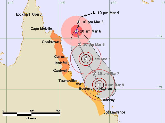
TROPICAL CYCLONE ADVICE NUMBER 4
Issued by the Bureau of Meteorology, Brisbane
Issued at 7:50am on Friday the 6th of March 2009
A Cyclone WARNING is now current for coastal areas from Cape Melville to
Cardwell. A Cyclone WATCH is current for coastal and island communities from
Cardwell to Mackay.
Tropical Cyclone Hamish, a category 2 cyclone, is located in the northwestern
Coral Sea and at 7:00 am EST was estimated to be 235 kilometres northeast of
Cooktown and 345 kilometres north northeast of Cairns, moving south southwest at
8 kilometres per hour.
Tropical Cyclone Hamish is expected to continue to move south-southwest,
bringing it a little closer to the north tropical coast while deepening.
Damaging wind gusts may affect coastal and island communities between Cape
Melville and Cardwell by afternoon or evening today.
In the longer term the system is expected to take a south-southeastwards track
and damaging wind gusts may develop about coastal and island communities between
Cardwell and Mackay within 24 to 48 hours.
Details of Tropical Cyclone Hamish at 7:00 am EST:
.Centre located near...... 14.0 degrees South 146.8 degrees East
.Location accuracy........ within 37 kilometres
.Recent movement.......... towards the south southwest at 8 kilometres per hour
.Wind gusts near centre... 130 kilometres per hour
.Severity category........ 2
.Central pressure......... 988 hectoPascals
People between Cape Melville and Cardwell should immediately commence or
continue
preparations, especially securing boats and property.
People between Cardwell and Mackay should consider what action they will need to
take if the cyclone threat increases. If you are unsure about the actions to be
taken, information is available from your local government or local State
Emergency Service.
The next advice will be issued by 11:00 am EST Friday 06 March.
This warning is also available through TV and Radio Broadcasts; the Bureau's
website at http://www.bom.gov.au or call 1300 659 212. The Bureau and the State
Emergency Service would appreciate this warning being broadcast regularly.
Australian Government Bureau of Meteorology
Queensland
Tropical Cyclone Warning Centre
Media: The Standard Emergency Warning Signal should NOT be used with this
warning.
TOP PRIORITY
TROPICAL CYCLONE ADVICE NUMBER 4
Issued by the Bureau of Meteorology, Brisbane
Issued at 7:50am on Friday the 6th of March 2009
A Cyclone WARNING is now current for coastal areas from Cape Melville to
Cardwell. A Cyclone WATCH is current for coastal and island communities from
Cardwell to Mackay.
Tropical Cyclone Hamish, a category 2 cyclone, is located in the northwestern
Coral Sea and at 7:00 am EST was estimated to be 235 kilometres northeast of
Cooktown and 345 kilometres north northeast of Cairns, moving south southwest at
8 kilometres per hour.
Tropical Cyclone Hamish is expected to continue to move south-southwest,
bringing it a little closer to the north tropical coast while deepening.
Damaging wind gusts may affect coastal and island communities between Cape
Melville and Cardwell by afternoon or evening today.
In the longer term the system is expected to take a south-southeastwards track
and damaging wind gusts may develop about coastal and island communities between
Cardwell and Mackay within 24 to 48 hours.
Details of Tropical Cyclone Hamish at 7:00 am EST:
.Centre located near...... 14.0 degrees South 146.8 degrees East
.Location accuracy........ within 37 kilometres
.Recent movement.......... towards the south southwest at 8 kilometres per hour
.Wind gusts near centre... 130 kilometres per hour
.Severity category........ 2
.Central pressure......... 988 hectoPascals
People between Cape Melville and Cardwell should immediately commence or
continue
preparations, especially securing boats and property.
People between Cardwell and Mackay should consider what action they will need to
take if the cyclone threat increases. If you are unsure about the actions to be
taken, information is available from your local government or local State
Emergency Service.
The next advice will be issued by 11:00 am EST Friday 06 March.
This warning is also available through TV and Radio Broadcasts; the Bureau's
website at http://www.bom.gov.au or call 1300 659 212. The Bureau and the State
Emergency Service would appreciate this warning being broadcast regularly.
0 likes


Re: Coral Sea: HAMISH - Tropical Cyclone
Hamish really starting to wrap on the latest SAT images. Looks RI has set in for the next 24hrs.
0 likes
Up to 60 kt. 80 kt is forecast.
AXAU21 ABRF 060106
IDQ20018
TROPICAL CYCLONE TECHNICAL BULLETIN: AUSTRALIA - EASTERN REGION
Issued by BRISBANE TROPICAL CYCLONE WARNING CENTRE
at: 0106 UTC 06/03/2009
Name: Tropical Cyclone Hamish
Identifier: 17U
Data At: 0000 UTC
Latitude: 14.3S
Longitude: 146.8E
Location Accuracy: within 20 nm [37 km]
Movement Towards: south southwest [201 deg]
Speed of Movement: 5 knots [10 km/h]
Maximum 10-Minute Wind: 60 knots [110 km/h]
Maximum 3-Second Wind Gust: 80 knots [150 km/h]
Central Pressure: 982 hPa
Radius of 34-knot winds NE quadrant: 100 nm [185 km]
Radius of 34-knot winds SE quadrant: 100 nm [185 km]
Radius of 34-knot winds SW quadrant: 100 nm [185 km]
Radius of 34-knot winds NW quadrant: 100 nm [185 km]
Radius of 48-knot winds NE quadrant: 35 nm [65 km]
Radius of 48-knot winds SE quadrant: 35 nm [65 km]
Radius of 48-knot winds SW quadrant: 35 nm [65 km]
Radius of 48-knot winds NW quadrant: 35 nm [65 km]
Radius of 64-knot winds:
Radius of Maximum Winds: 25 nm
Dvorak Intensity Code: T4.0/4.0/D1.5/24HRS
Pressure of outermost isobar: 1006 hPa
Radius of outermost closed isobar: 150 nm [280 km]
Storm Depth: Deep
FORECAST DATA
Date/Time : Location : Loc. Accuracy: Max Wind : Central Pressure
[UTC] : degrees : nm [km]: knots[km/h]: hPa
+12: 06/1200: 15.6S 147.1E: 050 [095]: 070 [130]: 975
+24: 07/0000: 17.0S 147.7E: 080 [150]: 080 [150]: 966
+36: 07/1200: 18.4S 148.5E: 110 [210]: 080 [150]: 963
+48: 08/0000: 19.6S 149.0E: 145 [270]: 080 [150]: 963
+60: 08/1200: 20.7S 149.7E: 190 [355]: 080 [150]: 962
+72: 09/0000: 21.3S 149.6E: 240 [445]: 080 [150]: 960
REMARKS:
Deep convection wraps 0.80 on log10 spiral with an added 0.5 for W band. DT is
4.0. Well organised banding on recent VIS and microwave images. System is
expected to continue to intensify under weak shear.
Good outlfow on all but the northeast quadrant and CMSS winds show an upper
level ridge with strong divergence aloft. Stronger shear exists aloft to the
south, though is modelled to weaken as the system moves into this region.
The current main steering is a ridge to the east, though is likely to weaken and
allow for a longer term SSE track.
Copyright Commonwealth of Australia
==
The next bulletin for this system will be issued by: 06/0700 UTC by Brisbane
TCWC.
0 likes
-
HURAKAN
- Professional-Met
- Posts: 46084
- Age: 39
- Joined: Thu May 20, 2004 4:34 pm
- Location: Key West, FL
- Contact:
Australian Government Bureau of Meteorology
Queensland
Tropical Cyclone Warning Centre
Media: The Standard Emergency Warning Signal should NOT be used with this
warning.
TOP PRIORITY FOR
TROPICAL CYCLONE ADVICE NUMBER 5
Issued by the Bureau of Meteorology, Brisbane
Issued at 11:00am on Friday the 6th of March 2009
A Cyclone WARNING is now current for coastal areas from Cape Melville to
Cardwell. A Cyclone WATCH is current for coastal and island communities from
Cardwell to Saint Lawrence.
Tropical Cyclone Hamish, a category 2 cyclone, is located in the northwestern
Coral Sea and at 10:00 am EST was estimated to be 210 kilometres northeast of
Cooktown and 310 kilometres north northeast of Cairns, moving south southwest at
10 kilometres per hour.
Tropical Cyclone Hamish is expected to move slowly south, bringing it a little
closer to the north tropical coast, while deepening. Damaging wind gusts may
affect coastal and island communities between Cape Melville and Cardwell during
this afternoon or evening.
In the longer term the system is expected to take a south-southeastwards track
and damaging wind gusts may develop about coastal and island communities between
Cardwell and Saint Lawrence within 24 to 48 hours.
As the cyclone approaches the coast, sea levels are expected to be elevated
above the normal expected tide along the coastline south of the cyclone. Large
waves may produce minor flooding along the foreshore. People living in areas
likely to be affected by this flooding should take measures to protect their
property as much as possible and be prepared to help their neighbours.
Details of Tropical Cyclone Hamish at 10:00 am EST:
.Centre located near...... 14.3 degrees South 146.8 degrees East
.Location accuracy........ within 37 kilometres
.Recent movement.......... towards the south southwest at 10 kilometres per hour
.Wind gusts near centre... 150 kilometres per hour
.Severity category........ 2
.Central pressure......... 982 hectoPascals
People between Cape Melville and Cardwell should immediately commence or
continue preparations, especially securing boats and property.
People between Cardwell and Mackay should consider what action they will need to
take if the cyclone threat increases. If you are unsure about the actions to be
taken, information is available from your local government or local State
Emergency Service.
The next advice will be issued by 2:00 pm EST Friday 06 March.
This warning is also available through TV and Radio Broadcasts; the Bureau's
website at http://www.bom.gov.au or call 1300 659 212. The Bureau and the State
Emergency Service would appreciate this warning being broadcast regularly.
0 likes

-
HURAKAN
- Professional-Met
- Posts: 46084
- Age: 39
- Joined: Thu May 20, 2004 4:34 pm
- Location: Key West, FL
- Contact:
Re: Coral Sea: HAMISH - Tropical Cyclone
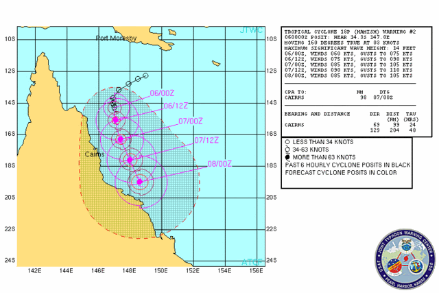
WTPS31 PGTW 060300
MSGID/GENADMIN/NAVMARFCSTCEN PEARL HARBOR HI/JTWC//
SUBJ/TROPICAL CYCLONE 18P (HAMISH) WARNING NR 002//
RMKS/
1. TROPICAL CYCLONE 18P (HAMISH) WARNING NR 002
01 ACTIVE TROPICAL CYCLONE IN SOUTHPAC
MAX SUSTAINED WINDS BASED ON ONE-MINUTE AVERAGE
---
WARNING POSITION:
060000Z --- NEAR 14.3S 147.0E
MOVEMENT PAST SIX HOURS - 160 DEGREES AT 03 KTS
POSITION ACCURATE TO WITHIN 040 NM
POSITION BASED ON CENTER LOCATED BY SATELLITE
PRESENT WIND DISTRIBUTION:
MAX SUSTAINED WINDS - 060 KT, GUSTS 075 KT
WIND RADII VALID OVER OPEN WATER ONLY
RADIUS OF 050 KT WINDS - 025 NM NORTHEAST QUADRANT
025 NM SOUTHEAST QUADRANT
025 NM SOUTHWEST QUADRANT
025 NM NORTHWEST QUADRANT
RADIUS OF 034 KT WINDS - 055 NM NORTHEAST QUADRANT
055 NM SOUTHEAST QUADRANT
040 NM SOUTHWEST QUADRANT
040 NM NORTHWEST QUADRANT
REPEAT POSIT: 14.3S 147.0E
---
FORECASTS:
12 HRS, VALID AT:
061200Z --- 15.1S 147.1E
MAX SUSTAINED WINDS - 075 KT, GUSTS 090 KT
WIND RADII VALID OVER OPEN WATER ONLY
RADIUS OF 064 KT WINDS - 015 NM NORTHEAST QUADRANT
015 NM SOUTHEAST QUADRANT
015 NM SOUTHWEST QUADRANT
015 NM NORTHWEST QUADRANT
RADIUS OF 050 KT WINDS - 035 NM NORTHEAST QUADRANT
035 NM SOUTHEAST QUADRANT
030 NM SOUTHWEST QUADRANT
030 NM NORTHWEST QUADRANT
RADIUS OF 034 KT WINDS - 085 NM NORTHEAST QUADRANT
085 NM SOUTHEAST QUADRANT
075 NM SOUTHWEST QUADRANT
075 NM NORTHWEST QUADRANT
VECTOR TO 24 HR POSIT: 165 DEG/ 06 KTS
---
24 HRS, VALID AT:
070000Z --- 16.3S 147.4E
MAX SUSTAINED WINDS - 085 KT, GUSTS 105 KT
WIND RADII VALID OVER OPEN WATER ONLY
RADIUS OF 064 KT WINDS - 020 NM NORTHEAST QUADRANT
020 NM SOUTHEAST QUADRANT
020 NM SOUTHWEST QUADRANT
020 NM NORTHWEST QUADRANT
RADIUS OF 050 KT WINDS - 040 NM NORTHEAST QUADRANT
040 NM SOUTHEAST QUADRANT
035 NM SOUTHWEST QUADRANT
035 NM NORTHWEST QUADRANT
RADIUS OF 034 KT WINDS - 085 NM NORTHEAST QUADRANT
085 NM SOUTHEAST QUADRANT
075 NM SOUTHWEST QUADRANT
075 NM NORTHWEST QUADRANT
VECTOR TO 36 HR POSIT: 155 DEG/ 07 KTS
---
36 HRS, VALID AT:
071200Z --- 17.6S 148.0E
MAX SUSTAINED WINDS - 090 KT, GUSTS 110 KT
WIND RADII VALID OVER OPEN WATER ONLY
RADIUS OF 064 KT WINDS - 025 NM NORTHEAST QUADRANT
025 NM SOUTHEAST QUADRANT
025 NM SOUTHWEST QUADRANT
025 NM NORTHWEST QUADRANT
RADIUS OF 050 KT WINDS - 045 NM NORTHEAST QUADRANT
045 NM SOUTHEAST QUADRANT
040 NM SOUTHWEST QUADRANT
040 NM NORTHWEST QUADRANT
RADIUS OF 034 KT WINDS - 095 NM NORTHEAST QUADRANT
095 NM SOUTHEAST QUADRANT
085 NM SOUTHWEST QUADRANT
085 NM NORTHWEST QUADRANT
VECTOR TO 48 HR POSIT: 160 DEG/ 08 KTS
---
EXTENDED OUTLOOK:
48 HRS, VALID AT:
080000Z --- 19.0S 148.6E
MAX SUSTAINED WINDS - 085 KT, GUSTS 105 KT
WIND RADII VALID OVER OPEN WATER ONLY
RADIUS OF 064 KT WINDS - 030 NM NORTHEAST QUADRANT
030 NM SOUTHEAST QUADRANT
030 NM SOUTHWEST QUADRANT
030 NM NORTHWEST QUADRANT
RADIUS OF 050 KT WINDS - 050 NM NORTHEAST QUADRANT
050 NM SOUTHEAST QUADRANT
045 NM SOUTHWEST QUADRANT
045 NM NORTHWEST QUADRANT
RADIUS OF 034 KT WINDS - 100 NM NORTHEAST QUADRANT
100 NM SOUTHEAST QUADRANT
090 NM SOUTHWEST QUADRANT
090 NM NORTHWEST QUADRANT
---
REMARKS:
060300Z POSITION NEAR 14.5S 147.0E.
TROPICAL CYCLONE (TC) 18P (HAMISH), LOCATED APPROXIMATELY 175 NM
NORTH-NORTHEAST OF THE CAIRNS, AUSTRALIA HAS TRACKED SOUTH-
SOUTHEASTWARD AT 03 KNOTS WHILE RAPIDLY INTENSIFYING OVER THE PAST
06 HOURS. ANIMATED MULTISPECTRAL SATELLITE IMAGERY AND A 052302Z
AMSUB IMAGE DEPICT TIGHTLY CURVED BANDING WRAPPING INTO A WELL
DEFINED LOW-LEVEL CIRCULATION CENTER (LLCC). A 052301Z ASCAT IMAGE
CONFIRMS THE LLCC WITH 50 KNOT UNFLAGGED WINDS NEAR THE CENTER.
OBSERVATIONS FROM BOUGAINVILLE REEF (100 NM SOUTH) INDICATE
SOUTHEASTERLY SUSTAINED WINDS AT 40 KNOTS OVER THE PAST THREE HOURS.
POSITION CONFIDENCE IS QUITE GOOD AND IS BASED UPON A COMBINATION OF
ANIMATED METSAT IMAGERY, MICROWAVE IMAGERY AND RADAR DATA. THE
SYSTEM IS LOCATED WITHIN A FAVORABLE ENVIRONMENT WITH WEAK VERTICAL
WIND SHEAR, WARM SST > 28C AND DEEP MOISTURE. ANIMATED WATER VAPOR
IMAGERY INDICATES AN ANTICYCLONE OVER THE CENTER WITH GOOD RADIAL
OUTFLOW. CURRENT INTENSITY IS BASED UPON DVORAK INTENSITY ESTIMATES
RANGING FROM 55 TO 65 KNOTS. TC 18P IS FORECAST TO CONTINUE
INTENSIFYING UNDER FAVORABLE CONDITIONS, REACHING A MAX OF 90 KNOTS
NEAR TAU 36. AFTER THIS TIME, A COMBINATION OF INCREASED VERTICAL
WIND SHEAR CAUSED BY AN APPROACHING SHORT WAVE TROUGH AND LAND
INTERACTION AS THE STORM NEARS THE COASTLINE WILL BEGIN WEAKENING
THE STORM BY THE END OF THE FORECAST PERIOD. THE AVAILABLE MODEL
GUIDANCE IS IN GOOD AGREEMENT WITH THE FORECAST. MAXIMUM SIGNIFICANT
WAVE HEIGHT AT 060000Z IS 14 FEET. NEXT WARNINGS AT 061500Z AND
070300Z.
0 likes
-
HURAKAN
- Professional-Met
- Posts: 46084
- Age: 39
- Joined: Thu May 20, 2004 4:34 pm
- Location: Key West, FL
- Contact:
TPPS10 PGTW 060004
A. TROPICAL CYCLONE 18P (HAMISH)
B. 05/2330Z
C. 14.3S
D. 147.1E
E. THREE/MTSAT
F. T4.0/4.0/D2.5/24HRS STT: D1.0/03HRS
G. IR/EIR/VIS/MSI
H. REMARKS: 15A/PBO BANDING EYE/ANMTN. SYSTEM CONTINUES TO
RAPIDLY DEVELOP WITH CNVCTN WRAPPING .80 ON LOG10 SPIRAL
YIELDING A CF OF 3.5. ADDED .5 FOR BANDING TO YIELD A DT OF 4.0.
PT AGREES. MET YIELDS AN UNREP 3.0. DBO DT.
I. ADDITIONAL POSITIONS:
05/1852Z 14.1S 146.9E AMSU
05/2006Z 13.9S 146.8E WIND
05/2010Z 13.6S 146.9E AMSU
05/2103Z 13.7S 146.9E SSMS
UEHARA
0 likes
Who is online
Users browsing this forum: No registered users and 43 guests