Severe weather possible March 7 to 10?

U.S. & Caribbean Weather Discussions and Severe Weather Events

Moderator: S2k Moderators

Forum rules

The posts in this forum are NOT official forecast and should not be used as such. They are just the opinion of the poster and may or may not be backed by sound meteorological data. They are NOT endorsed by any professional institution or STORM2K.

Help Support Storm2K
Message
Author
Ed Mahmoud

Re: Severe weather possible March 7 to 10?

#121 Postby Ed Mahmoud » Mon Mar 09, 2009 12:32 pm

Ed Mahmoud wrote:Henry Margusity, AccuWx's severe expert, expects an upgrade on the SWODY2, to a MODERATE RISK, centered in the MO/IL/IN area.

ai9D (sp?) may be busy again tomorrow.


Henry expected wrongly...
0 likes   

Ed Mahmoud

Re: Severe weather possible March 7 to 10?

#122 Postby Ed Mahmoud » Mon Mar 09, 2009 1:02 pm

Getting some breaks in the clouds in the warm sector in Oklahoma.

Wind from the S (190 degrees) at 24 MPH (21 KT) gusting to 31 MPH (27 KT)
Visibility 10 mile(s)
Sky conditions overcast
Temperature 77.0 F (25.0 C)
Dew Point 57.0 F (13.9 C)
Relative Humidity 50%
Pressure (altimeter) 29.88 in. Hg (1011 hPa)
Pressure tendency 0.06 inches (1.9 hPa) lower than three hours ago
ob KOKC 091752Z 19021G27KT 10SM SCT060 SCT180 OVC250 25/14 A2988 RMK AO2 PK WND 20031/1728 SLP109 T02500139 10250 20133 58019


OKC is now one full degree Celcius warmer than the NAM forecast, which may mean the surface based instability is also a tad higher than forecast.
0 likes   

User avatar
Dave
Retired Staff
Retired Staff
Posts: 13442
Age: 74
Joined: Tue Aug 01, 2006 3:57 pm
Location: Milan Indiana
Contact:

#123 Postby Dave » Mon Mar 09, 2009 1:52 pm

I've got more info on that touchdown north of Milan now, it did not come down 1 mile north of town, it came down 6 miles north of Milan Indiana and did damage to a barn and a structure.
That report came in via a firefighter for Sunman Indiana.

The reported touchdown 1 mile north of me was sent by someone calling themselves a 'trained spotter' into a tv station in Cincinnati. We still don't know who sent that report on into Wilmington. No spotters under EMA or ham radio had spotters north of Milan at the time of the incident. Still working on that report and who sent it in.

Miss Mary has a link into another TV station on this thread that I think had some pictures of the actual touchdown. If not I've got them up on photobucket but will have to get them later. My #1 laptop crashed at midnight last night and am now reloading windows Xp to the system. Fun day.
0 likes   

RL3AO
Moderator-Pro Met
Moderator-Pro Met
Posts: 16308
Joined: Thu Jun 14, 2007 10:03 pm
Location: NC

Re: Severe weather possible March 7 to 10?

#124 Postby RL3AO » Mon Mar 09, 2009 2:57 pm

Image

MESOSCALE DISCUSSION 0217
NWS STORM PREDICTION CENTER NORMAN OK
0213 PM CDT MON MAR 09 2009

AREAS AFFECTED...PARTS OF NW TX / CNTRL OK

CONCERNING...SEVERE POTENTIAL...WATCH LIKELY

VALID 091913Z - 092015Z

SEVERE POTENTIAL WILL LIKELY INCREASE STEADILY THIS AFTN. A WW MAY
BE NEEDED AS EARLY AS 20Z.

VISIBLE SATELLITE IMAGERY SHOWS DEVELOPING CU FIELD ACROSS MUCH OF
N-CNTRL TX AND S-CNTRL OK. RECENT SURFACE ANALYSIS INDICATES RAPID
MOISTURE RETURN ACROSS THE S-CNTRL PLAINS BEHIND WARM FRONT WITH
DEWPOINTS IN THE UPPER 50S TO NEAR 60 F IN OKLA WITH LOWER 60S IN
N-CNTRL TX. THIS HAS OCCURRED IN PART DUE TO DIABATIC
HEATING--RESULTING IN SUFFICIENT PBL MIXING OF 925-875 MB MOISTURE
TO SURFACE.

CONVECTIVE INITIATING UNCERTAINTIES ARE WHETHER ISOLD TSTMS CAN
BREACH THE CAP THIS AFTN ALONG LOW LEVEL CONFLUENCE ZONE AHEAD OF
INCREASING ASCENT ASSOCIATED WITH IMPULSE MOVING INTO THE REGION
FROM NM. LATEST RUC FORECAST SOUNDINGS INDICATE THE CAP WILL WEAKEN
SUBSTANTIALLY IN SWRN OK --FSI 79/60F-- BY 21-22Z. IF THIS OCCURS
/20-22Z PERIOD/ A WW WILL LIKELY BE NEEDED IN THE NEXT FEW HRS.
STRONG...VEERING WIND PROFILES WITH HGHT WILL FAVOR DISCRETE
STORMS...INCLUDING SUPERCELLS. LARGE HAIL/DMGG WINDS AND ISOLD
TORNADOES WILL BE POSSIBLE...ESPECIALLY WITH ANY LONGER LIVED
SUPERCELL AS LLJ STRENGTHENS TOWARDS 00Z.

..SMITH.. 03/09/2009
0 likes   

User avatar
srainhoutx
S2K Supporter
S2K Supporter
Posts: 6919
Age: 67
Joined: Sun Jan 14, 2007 11:34 am
Location: Haywood County, NC
Contact:

Re: Severe weather possible March 7 to 10?

#125 Postby srainhoutx » Mon Mar 09, 2009 3:29 pm

Image

DAY 1 CONVECTIVE OUTLOOK
NWS STORM PREDICTION CENTER NORMAN OK
0245 PM CDT MON MAR 09 2009

VALID 092000Z - 101200Z

...THERE IS A SLGT RISK OF SVR TSTMS ACROSS THE MID-MS VLY SWWD INTO
THE SRN PLNS...

...OK/KS INTO MO...
NO CHANGES ARE NEEDED TO PREV FCST.

MODELS ARE UNDERESTIMATING LLVL MOISTURE/TEMPERATURE PROFILES THIS
AFTN. TEMPS WARMING WELL INTO THE 70S WITH SFC DEW POINTS UPR
50S/NEAR 60 DEG F ARE COMMON ALONG/S OF KS BORDER AT 19Z. THIS WAS
RESULTING IN HIGHER BUOYANCY POTENTIAL AND WEAKER CINH.

SATL/PROFILERS SUGGEST NEXT IMPULSE WAS EJECTING INTO THE SPLNS OF W
TX EARLY THIS AFTN. AS THIS FEATURE EJECTS NEWD...THE BOUNDARY
PRESENT FROM NEAR KPNC SWWD INTO SWRN OK SHOULD STRENGTHEN/DEEPEN.
ALL MODELS SUGGEST SFC-BASED INITIATION IN THIS CORRIDOR BY LATE
AFTN. STRONGLY VEERING WIND PROFILES WITH HEIGHT AND 2-6KM SHEAR
ORIENTED NEARLY PERPENDICULAR WITH THE BOUNDARY WILL FAVOR DISCRETE
SUPERCELLS WITH LARGE HAIL AND DMGG WINDS.

TORNADO RISK WILL BE MAXIMIZED THIS EVENING IN A CORRIDOR ALONG/N OF
I-44 FROM CNTRL/NERN OK INTO SERN KS AND SWRN MO. MESO-LOW HAS
FORMED NEAR SEILING OK AND WILL LIKELY TRACK ENE ALONG NRN EDGE OF
MORE ROBUST LLVL THETA-E. ENHANCED AND SLIGHTLY BACKED LLVL FLOW
ATTENDANT TO THIS FEATURE WILL BOOST SRH AND COUPLED WITH EVENING
LOWERING OF THE LCL MAY RESULT IN A FEW TORNADOES. /RACY
0 likes   

Ed Mahmoud

Re: Severe weather possible March 7 to 10?

#126 Postby Ed Mahmoud » Mon Mar 09, 2009 3:54 pm

Image

URGENT - IMMEDIATE BROADCAST REQUESTED
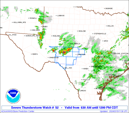
TORNADO WATCH NUMBER 52
NWS STORM PREDICTION CENTER NORMAN OK
350 PM CDT MON MAR 9 2009

THE NWS STORM PREDICTION CENTER HAS ISSUED A
TORNADO WATCH FOR PORTIONS OF

SOUTHEAST KANSAS
CENTRAL AND NORTHEAST OKLAHOMA

EFFECTIVE THIS MONDAY AFTERNOON AND EVENING FROM 350 PM UNTIL
1000 PM CDT.

TORNADOES...HAIL TO 2 INCHES IN DIAMETER...THUNDERSTORM WIND
GUSTS TO 70 MPH...AND DANGEROUS LIGHTNING ARE POSSIBLE IN THESE
AREAS.

THE TORNADO WATCH AREA IS APPROXIMATELY ALONG AND 70 STATUTE
MILES EAST AND WEST OF A LINE FROM 35 MILES SOUTH SOUTHWEST OF
FORT SILL OKLAHOMA TO 35 MILES NORTHWEST OF CHANUTE KANSAS. FOR
A COMPLETE DEPICTION OF THE WATCH SEE THE ASSOCIATED WATCH
OUTLINE UPDATE (WOUS64 KWNS WOU2).

REMEMBER...A TORNADO WATCH MEANS CONDITIONS ARE FAVORABLE FOR
TORNADOES AND SEVERE THUNDERSTORMS IN AND CLOSE TO THE WATCH
AREA. PERSONS IN THESE AREAS SHOULD BE ON THE LOOKOUT FOR
THREATENING WEATHER CONDITIONS AND LISTEN FOR LATER STATEMENTS
AND POSSIBLE WARNINGS.

DISCUSSION...CU/TCU FIELD CONTINUES TO GROW ACROSS MUCH OF CENTRAL
OK...WHILE AIRMASS DESTABILIZES INTO SOUTHEAST KS. LEADING EDGE OF
STRONGER FORCING IS MOVING THROUGH THE TX PANHANDLE AND WILL LIKELY
RESULT IN SCATTERED THUNDERSTORM INITIATION SOON OVER WESTERN OK.
THESE STORMS WILL TRACK EASTWARD ACROSS WATCH AREA DURING THE LATE
AFTERNOON AND EVENING. FAVORABLE LOW LEVEL SHEAR PROFILES WILL
PROMOTE SUPERCELL STRUCTURES WITH A RISK OF A FEW TORNADOES.

AVIATION...TORNADOES AND A FEW SEVERE THUNDERSTORMS WITH HAIL
SURFACE AND ALOFT TO 2 INCHES. EXTREME TURBULENCE AND SURFACE
WIND GUSTS TO 60 KNOTS. A FEW CUMULONIMBI WITH MAXIMUM TOPS TO
450. MEAN STORM MOTION VECTOR 25040.


...HART


SEL2


WOUS64 KWNS 092047
WOU2

BULLETIN - IMMEDIATE BROADCAST REQUESTED
TORNADO WATCH OUTLINE UPDATE FOR WT 52
NWS STORM PREDICTION CENTER NORMAN OK
350 PM CDT MON MAR 9 2009

TORNADO WATCH 52 IS IN EFFECT UNTIL 1000 PM CDT FOR THE
FOLLOWING LOCATIONS

KSC001-015-019-035-049-073-099-125-133-191-205-207-100300-
/O.NEW.KWNS.TO.A.0052.090309T2050Z-090310T0300Z/

KS
. KANSAS COUNTIES INCLUDED ARE

ALLEN BUTLER CHAUTAUQUA
COWLEY ELK GREENWOOD
LABETTE MONTGOMERY NEOSHO
SUMNER WILSON WOODSON


OKC003-011-015-017-027-031-033-035-037-039-043-047-049-051-053-
065-067-071-073-075-081-083-087-093-103-105-109-113-117-119-125-
131-137-141-143-147-149-100300-
/O.NEW.KWNS.TO.A.0052.090309T2050Z-090310T0300Z/

OK
. OKLAHOMA COUNTIES INCLUDED ARE

ALFALFA BLAINE CADDO
CANADIAN CLEVELAND COMANCHE
COTTON CRAIG CREEK
CUSTER DEWEY GARFIELD
GARVIN GRADY GRANT
JACKSON JEFFERSON KAY
KINGFISHER KIOWA LINCOLN
LOGAN MAJOR MCCLAIN
NOBLE NOWATA OKLAHOMA
OSAGE PAWNEE PAYNE
POTTAWATOMIE ROGERS STEPHENS
TILLMAN TULSA WASHINGTON
WASHITA


ATTN...WFO...ICT...OUN...TSA...


Watch 52 Status Report Message has not been issued yet.
0 likes   

Shockwave
Tropical Storm
Tropical Storm
Posts: 167
Joined: Fri Jul 25, 2008 7:33 am
Location: Lafayette, TN
Contact:

Re: Severe weather possible March 7 to 10?

#127 Postby Shockwave » Mon Mar 09, 2009 5:39 pm

Starting to see some individual cells pop-up to the east of Enid, OK...moving off to the NE.
0 likes   

User avatar
Bunkertor
Category 5
Category 5
Posts: 3397
Joined: Tue May 09, 2006 3:48 pm

#128 Postby Bunkertor » Mon Mar 09, 2009 5:52 pm

^Nothing at the moment
0 likes   

RL3AO
Moderator-Pro Met
Moderator-Pro Met
Posts: 16308
Joined: Thu Jun 14, 2007 10:03 pm
Location: NC

#129 Postby RL3AO » Mon Mar 09, 2009 5:56 pm

A few weak cells trying to pop in SW Oklahoma west of Frederick.
0 likes   

User avatar
Texas Snowman
Storm2k Moderator
Storm2k Moderator
Posts: 6151
Joined: Fri Jan 25, 2008 11:29 am
Location: Denison, Texas

Re: Severe weather possible March 7 to 10?

#130 Postby Texas Snowman » Mon Mar 09, 2009 6:15 pm

Couple of cells looking a bit stronger near Quannah, Tx.
0 likes   

RL3AO
Moderator-Pro Met
Moderator-Pro Met
Posts: 16308
Joined: Thu Jun 14, 2007 10:03 pm
Location: NC

#131 Postby RL3AO » Mon Mar 09, 2009 6:19 pm

Two MD's for the WW.

Image

Image
0 likes   

Shockwave
Tropical Storm
Tropical Storm
Posts: 167
Joined: Fri Jul 25, 2008 7:33 am
Location: Lafayette, TN
Contact:

Re: Severe weather possible March 7 to 10?

#132 Postby Shockwave » Mon Mar 09, 2009 6:28 pm

Cell NW of Ponca City, OK is one I'm keeping an eye on. It is moving out of the more favorable area for development, but the SPC has the region it's in outlined in the greatest tornadic storm potential area.
0 likes   

User avatar
Texas Snowman
Storm2k Moderator
Storm2k Moderator
Posts: 6151
Joined: Fri Jan 25, 2008 11:29 am
Location: Denison, Texas

Re: Severe weather possible March 7 to 10?

#133 Postby Texas Snowman » Mon Mar 09, 2009 6:33 pm

That is a rather decent looking cell sitting off by itself...
0 likes   

Ed Mahmoud

Re: Severe weather possible March 7 to 10?

#134 Postby Ed Mahmoud » Mon Mar 09, 2009 6:40 pm

Maybe something in noisy SW flow triggering a shower or two near Midland, which may be what really fires up Oklahoma in a few hours when it gets there.


Image
0 likes   

RL3AO
Moderator-Pro Met
Moderator-Pro Met
Posts: 16308
Joined: Thu Jun 14, 2007 10:03 pm
Location: NC

#135 Postby RL3AO » Mon Mar 09, 2009 6:45 pm

First warning.

BULLETIN - IMMEDIATE BROADCAST REQUESTED
SEVERE THUNDERSTORM WARNING
NATIONAL WEATHER SERVICE NORMAN OK
643 PM CDT MON MAR 9 2009

THE NATIONAL WEATHER SERVICE IN NORMAN HAS ISSUED A

* SEVERE THUNDERSTORM WARNING FOR...
NORTHERN ALFALFA COUNTY IN NORTHWEST OKLAHOMA...
EASTERN WOODS COUNTY IN NORTHWEST OKLAHOMA...
0 likes   

RL3AO
Moderator-Pro Met
Moderator-Pro Met
Posts: 16308
Joined: Thu Jun 14, 2007 10:03 pm
Location: NC

#136 Postby RL3AO » Mon Mar 09, 2009 6:56 pm

A few of the cells north of Frederick are getting going.

Image
0 likes   

CrazyC83
Professional-Met
Professional-Met
Posts: 34001
Joined: Tue Mar 07, 2006 11:57 pm
Location: Deep South, for the first time!

#137 Postby CrazyC83 » Mon Mar 09, 2009 7:05 pm

Looks like things should get going pretty quickly.
0 likes   

Ed Mahmoud

Re: Severe weather possible March 7 to 10?

#138 Postby Ed Mahmoud » Mon Mar 09, 2009 7:17 pm

I don't think SPC outlooked down to the Permian Basin earlier...


Image
0 likes   

CrazyC83
Professional-Met
Professional-Met
Posts: 34001
Joined: Tue Mar 07, 2006 11:57 pm
Location: Deep South, for the first time!

#139 Postby CrazyC83 » Mon Mar 09, 2009 7:20 pm

It is a slight risk down there, but a Severe Thunderstorm Watch should probably be considered in central Texas.
0 likes   

RL3AO
Moderator-Pro Met
Moderator-Pro Met
Posts: 16308
Joined: Thu Jun 14, 2007 10:03 pm
Location: NC

Re: Severe weather possible March 7 to 10?

#140 Postby RL3AO » Mon Mar 09, 2009 7:20 pm

Heres a link that shows the streams of different chasers on a map with radar and the works.

http://tornadovideos.net/full-screen-chaser-video.php
0 likes   


Return to “USA & Caribbean Weather”

Who is online

Users browsing this forum: 869MB, houstonkid75 and 49 guests