Southern Plains winter wx thread (2008-2009)

Winter Weather Discussion

Moderator: S2k Moderators

Forum rules

The posts in this forum are NOT official forecast and should not be used as such. They are just the opinion of the poster and may or may not be backed by sound meteorological data. They are NOT endorsed by any professional institution or STORM2K.

Help Support Storm2K
Message
Author
Ed Mahmoud

Re: Southern Plains winter wx thread

#1301 Postby Ed Mahmoud » Wed Mar 11, 2009 10:20 pm

0Z NAM loves EWG, looks to drop a slushy/sleety 3 or 5 inches on OKC tomorrow.


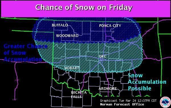
I hope schools pull the trigger on canx early if it looks like the models will verify, or buses will be in bar ditches across the OKC area tomorrow afternoon, per NAM.


Image
0 likes   

Ed Mahmoud

Re: Southern Plains winter wx thread

#1302 Postby Ed Mahmoud » Wed Mar 11, 2009 10:31 pm

NWS OUN AFD update doesn't trust 0Z NAM.


But I am always a glass half full kind of guy.

New GFS starting...
0 likes   

User avatar
Extremeweatherguy
Category 5
Category 5
Posts: 11095
Joined: Mon Oct 10, 2005 8:13 pm
Location: Florida

#1303 Postby Extremeweatherguy » Wed Mar 11, 2009 10:32 pm

Yeah, I saw that Ed. Very extreme option offered up by the NAM for tomorrow. The text output shows over 0.70" of liquid-equivalent precipitation falling into a cold atmosphere, which would be more than enough to cause widespread problems.
0 likes   

Ed Mahmoud

Re: Southern Plains winter wx thread

#1304 Postby Ed Mahmoud » Wed Mar 11, 2009 10:59 pm

New GFS not as happy, maybe a car and grass dusting tomorrow, more late Friday into Saturday morning, but that won't cancel any school.


Mixed feelings, model wise, looking at AccuWx PPV QPF numbers, GFS much happier for my lawn, but our friends in the Sooner State get just cosmetic snow.
0 likes   

Ed Mahmoud

Re: Southern Plains winter wx thread

#1305 Postby Ed Mahmoud » Thu Mar 12, 2009 6:30 am

IMHO, time to let the children go back to bed.

URGENT - WINTER WEATHER MESSAGE
NATIONAL WEATHER SERVICE NORMAN OK
549 AM CDT THU MAR 12 2009


OKZ011>025-033>036-TXZ083-121800-
/O.NEW.KOUN.WW.Y.0003.090312T1300Z-090312T1800Z/
MAJOR-GARFIELD-NOBLE-ROGER MILLS-DEWEY-CUSTER-BLAINE-KINGFISHER-
LOGAN-PAYNE-BECKHAM-WASHITA-CADDO-CANADIAN-OKLAHOMA-HARMON-GREER-
KIOWA-JACKSON-HARDEMAN-
INCLUDING THE CITIES OF...FAIRVIEW...ENID...PERRY...CHEYENNE...
TALOGA...WEATHERFORD...CLINTON...WATONGA...KINGFISHER...GUTHRIE...
STILLWATER...ELK CITY...SAYRE...CORDELL...ANADARKO...YUKON...
EL RENO...MUSTANG...OKLAHOMA CITY...HOLLIS...MANGUM...HOBART...
ALTUS...QUANAH...CHILLICOTHE
549 AM CDT THU MAR 12 2009

...WINTER WEATHER ADVISORY IN EFFECT UNTIL 1 PM CDT THIS
AFTERNOON...

THE NATIONAL WEATHER SERVICE IN NORMAN HAS ISSUED A WINTER
WEATHER ADVISORY FOR A MIXTURE OF LIGHT FREEZING RAIN AND
SLEET... WHICH IS IN EFFECT UNTIL 1 PM CDT THIS AFTERNOON FOR MUCH
OF SOUTHWESTERN... WEST CENTRAL... AND CENTRAL OKLAHOMA.

PERIODS OF LIGHT FREEZING RAIN... FREEZING DRIZZLE... AND
SLEET... MIXING WITH LIGHT SNOW AT TIMES... WILL CONTINUE THIS
MORNING BEFORE TAPERING OFF THIS AFTERNOON. ALTHOUGH AMOUNTS WILL
BE LIGHT... ACCUMULATING ICE AND SLEET WILL RESULT IN LIGHT GLAZE
ON EXPOSED SURFACES AND MAY LEAD TO ICY BRIDGES AND OVERPASSES.

A WINTER WEATHER ADVISORY MEANS THAT PERIODS OF SNOW...SLEET...OR
FREEZING RAIN WILL CAUSE TRAVEL DIFFICULTIES. BE PREPARED FOR
SLIPPERY ROADS AND LIMITED VISIBILITIES...AND USE CAUTION WHILE
DRIVING.


Image
0 likes   

User avatar
Extremeweatherguy
Category 5
Category 5
Posts: 11095
Joined: Mon Oct 10, 2005 8:13 pm
Location: Florida

#1306 Postby Extremeweatherguy » Thu Mar 12, 2009 7:10 am

Big band of freezing rain, sleet and perhaps some snow is about to move in to the Oklahoma city metro area. Could get interesting over the next couple of hours..
0 likes   

User avatar
Extremeweatherguy
Category 5
Category 5
Posts: 11095
Joined: Mon Oct 10, 2005 8:13 pm
Location: Florida

#1307 Postby Extremeweatherguy » Thu Mar 12, 2009 9:44 am

No snow, but we have gotten a nice glazing of freezing rain this morning (with a few periods of sleet mixing in too). Lots of ice in the trees and on the cars, but the roads and sidewalks seem ok.
0 likes   

User avatar
Extremeweatherguy
Category 5
Category 5
Posts: 11095
Joined: Mon Oct 10, 2005 8:13 pm
Location: Florida

#1308 Postby Extremeweatherguy » Thu Mar 12, 2009 11:37 am

Temperatures are starting to reach/climb above freezing here now, and the ice is beginning to slowly melt.

All in all, this was a pretty un-exciting event. I guess I will have to wait until next year before seeing any real snow around these parts.
0 likes   

Ed Mahmoud

Re:

#1309 Postby Ed Mahmoud » Thu Mar 12, 2009 11:45 am

Extremeweatherguy wrote:Temperatures are starting to reach/climb above freezing here now, and the ice is beginning to slowly melt.

All in all, this was a pretty un-exciting event. I guess I will have to wait until next year before seeing any real snow around these parts.


Still moving to Florida for hurricane season?
0 likes   

User avatar
Extremeweatherguy
Category 5
Category 5
Posts: 11095
Joined: Mon Oct 10, 2005 8:13 pm
Location: Florida

Re: Re:

#1310 Postby Extremeweatherguy » Thu Mar 12, 2009 3:29 pm

Ed Mahmoud wrote:
Extremeweatherguy wrote:Temperatures are starting to reach/climb above freezing here now, and the ice is beginning to slowly melt.

All in all, this was a pretty un-exciting event. I guess I will have to wait until next year before seeing any real snow around these parts.


Still moving to Florida for hurricane season?
I travel to Florida quite often for various reasons, so yes it is pretty likely that I will be there at points during the upcoming hurricane season.
0 likes   

User avatar
Extremeweatherguy
Category 5
Category 5
Posts: 11095
Joined: Mon Oct 10, 2005 8:13 pm
Location: Florida

Re: Southern Plains winter wx thread

#1311 Postby Extremeweatherguy » Fri Mar 20, 2009 2:51 pm

Today's 12z GFS is showing yet another late season winter weather threat in the 192-216 hour range.
0 likes   

User avatar
Extremeweatherguy
Category 5
Category 5
Posts: 11095
Joined: Mon Oct 10, 2005 8:13 pm
Location: Florida

Re: Southern Plains winter wx thread

#1312 Postby Extremeweatherguy » Sat Mar 21, 2009 11:56 am

The latest GFS run continues to show the possibility of winter weather toward the end of next week...

[img]--old image--[/img]
Last edited by Extremeweatherguy on Mon Mar 23, 2009 2:36 pm, edited 1 time in total.
0 likes   

User avatar
srainhoutx
S2K Supporter
S2K Supporter
Posts: 6919
Age: 67
Joined: Sun Jan 14, 2007 11:34 am
Location: Haywood County, NC
Contact:

Re: Southern Plains winter wx thread

#1313 Postby srainhoutx » Sun Mar 22, 2009 10:06 pm

Maybe we need a gerenal Plains Topic. WOW...From flooding to Blizzard...snipet...

URGENT - WINTER WEATHER MESSAGE
NATIONAL WEATHER SERVICE RAPID CITY SD
227 PM MDT SUN MAR 22 2009

...POWERFUL SPRING BLIZZARD MONDAY AND TUESDAY...

.A DEEP AREA OF LOW PRESSURE WILL DEVELOP ACROSS NORTHEASTERN
COLORADO TONIGHT AND MOVE INTO SOUTHEASTERN SOUTH DAKOTA BY MONDAY
EVENING. ABUNDANT MOISTURE WILL FLOW NORTHWARD INTO EASTERN
WYOMING AND WESTERN SOUTH DAKOTA. MEANWHILE...A COLD FRONT WILL
SLIDE SOUTH OUT OF MONTANA...SETTING THE STAGE FOR SIGNIFICANT SNOW
AND VERY STRONG NORTHWEST WINDS. THE PRECIPITATION WILL START
OUT AS RAIN...THEN CHANGE TO SNOW FROM WEST TO EAST AS COLD AIR IS
WRAPPED INTO THE STORM SYSTEM. THERE MAY BE A SIGNIFICANT PERIOD
OF SLEET ON THE PLAINS EAST OF THE BLACK HILLS.

SNOWFALL ACCUMULATIONS OF 8 TO 16 INCHES ARE EXPECTED ACROSS
NORTHEAST WYOMING WITH 16 TO 24 INCHES EXPECTED ACROSS NORTHWEST
SOUTH DAKOTA. IN THE NORTHERN BLACK HILLS...30 TO 40 INCHES OF
SNOW IS EXPECTED. ACROSS SOUTHWEST SOUTH DAKOTA...THE SOUTHERN
BLACK HILLS AND ON THE PLAINS EAST OF THE BLACK HILLS...8 TO 14
INCHES OF SNOW IS EXPECTED
.

THE HEAVY SNOW ALONG WITH NORTHWEST WINDS OF 30 TO 45 MPH...WITH
WIND GUSTS AROUND 60 MPH...WILL RESULT IN WIDESPREAD BLIZZARD
CONDITIONS.

OUTSIDE OF THE BLACK HILLS...THE FOCUS SHOULD NOT BE SO MUCH ON THE
SNOWFALL AMOUNTS...AS THE STRONG WINDS WHICH WILL MAKE ANY
MEASUREMENT DIFFICULT. THE NEAR ZERO VISIBILITIES DUE TO BLOWING
AND DRIFTING SNOW WILL MAKE TRAVEL IMPOSSIBLE. BECAUSE OF THE WET
SNOW AND STRONG WINDS...THERE COULD BE AREAS WITH POWER OUTAGES.

http://forecast.weather.gov/wwamap/wwat ... %20warning

Latest Hazards...

http://www.srh.noaa.gov/nat_hazard.php
0 likes   

User avatar
Extremeweatherguy
Category 5
Category 5
Posts: 11095
Joined: Mon Oct 10, 2005 8:13 pm
Location: Florida

Re: Southern Plains winter wx thread

#1314 Postby Extremeweatherguy » Tue Mar 24, 2009 12:58 am

Tonight's 00z GFS looks good for some snow in OKC Friday into Saturday. Precipitation falls in the presence of sub-540 thicknesses, sub-0C 850mb temperatures, and sub-40F surface temperatures. Could make for a nice late season surprise.
0 likes   

User avatar
Extremeweatherguy
Category 5
Category 5
Posts: 11095
Joined: Mon Oct 10, 2005 8:13 pm
Location: Florida

#1315 Postby Extremeweatherguy » Tue Mar 24, 2009 9:17 am

OKC NWS now has snow/sleet in the forecast for Friday and Friday night.

http://i43.photobucket.com/albums/e371/ ... 1237916806
0 likes   

Ed Mahmoud

Re: Southern Plains winter wx thread

#1316 Postby Ed Mahmoud » Tue Mar 24, 2009 1:50 pm

By my eyeball interp, magic thickness and 850 mb freezing line crosses OKC between 1 pm and 7 pm CDT on Friday, and 3 to 6 tenths liquid falls after the magic transition begins.


Canadian model in 6 hour incremements from PSU e-Wall


3 to 6 inches if the model of The Great White North is correct. Of course, the ground would be warm and we have Springtime sun angles, but it looks like a fair amount of rain falls with 850 mb temps in the 40s dropping into the 30s before the transition, so hopefully the cold rain will knock some of the Spring heat out of the ground and road surfaces.


Only bad news, probably wasted as a school-canceller.


In Houston, I'd take a Friday late afternoon snow, just for the one every four year novelty, but OKC sees it every winter, so if I lived there I'd want school cancellations.
0 likes   

User avatar
Extremeweatherguy
Category 5
Category 5
Posts: 11095
Joined: Mon Oct 10, 2005 8:13 pm
Location: Florida

#1317 Postby Extremeweatherguy » Tue Mar 24, 2009 5:14 pm

The 18z GFS looks very impressive compared to earlier runs of the model...

http://www.nco.ncep.noaa.gov/pmb/nwprod ... p_078l.gif
http://www.nco.ncep.noaa.gov/pmb/nwprod ... p_084l.gif
http://www.nco.ncep.noaa.gov/pmb/nwprod ... p_090l.gif
http://www.nco.ncep.noaa.gov/pmb/nwprod ... p_096l.gif

...If it plays out, then some parts of northern Oklahoma could see well over a foot of snow!
0 likes   

User avatar
Extremeweatherguy
Category 5
Category 5
Posts: 11095
Joined: Mon Oct 10, 2005 8:13 pm
Location: Florida

#1318 Postby Extremeweatherguy » Tue Mar 24, 2009 10:24 pm

00z NAM looks good too. Several inches of snow for a large chunk of Oklahoma if it verifies.

00z GFS is very similar.

Based on these two runs, I expect the NWS forecasts tomorrow morning to look much more bullish on the snow threat. The Norman NWS office will probably up the wording in their AFDs and mention the possibility of a winter storm watch being issued during the afternoon shift if the model trends continue.
0 likes   

User avatar
Extremeweatherguy
Category 5
Category 5
Posts: 11095
Joined: Mon Oct 10, 2005 8:13 pm
Location: Florida

#1319 Postby Extremeweatherguy » Tue Mar 24, 2009 11:14 pm

OUN forecast sounding (from the 00z GFS) for 1am Saturday morning...

Image

Great snow sounding!


BTW,
as for liquid precipitation-equivalents being shown by the models..

-The NAM drops nearly 1" of liquid over OKC while the atmosphere is capable of snow. That would mean 10" of powder under perfect conditions, but since the ground will be warm and temperatures will start above freezing, 4-8" would be a more likely amount. Even so, that is still an incredible amount for OKC this late in the year, and would be the most snow the city has seen since November 2006.

-The GFS drops about 0.7-0.8" of liquid over OKC while the atmosphere is capable of snow. Under perfect conditions that would equate to 7-8", but with the above mentioned negatives, 3-5" would be a more likely amount.
0 likes   

User avatar
iorange55
Category 5
Category 5
Posts: 2388
Joined: Thu Nov 13, 2008 9:47 pm
Location: Big D

Re: Southern Plains winter wx thread

#1320 Postby iorange55 » Wed Mar 25, 2009 12:07 am

So nothing again for Dallas? Ugh it's so hard to be happy for you EWG :[
0 likes   


Return to “Winter Weather”

Who is online

Users browsing this forum: No registered users and 102 guests