
Preliminary report on that big tornado: it was a high-end EF2, and about 500 yards wide.
http://www.nws.noaa.gov/view/validProds ... &node=KBMX
2009 Severe Weather thread
Moderator: S2k Moderators
Forum rules

The posts in this forum are NOT official forecast and should not be used as such. They are just the opinion of the poster and may or may not be backed by sound meteorological data. They are NOT endorsed by any professional institution or STORM2K.

THE NWS STORM PREDICTION CENTER HAS ISSUED A
TORNADO WATCH FOR PORTIONS OF
SOUTHEAST ALABAMA
NORTHERN FLORIDA AND THE CENTRAL AND EASTERN FLORIDA
PANHANDLE
PANHANDLE
PANHANDLE
PANHANDLE
PANHANDLE
SOUTHERN GEORGIA
COASTAL WATERS
If you can't tell, there is a watch in effect for the Florida panhandle.
TORNADO WATCH FOR PORTIONS OF
SOUTHEAST ALABAMA
NORTHERN FLORIDA AND THE CENTRAL AND EASTERN FLORIDA
PANHANDLE
PANHANDLE
PANHANDLE
PANHANDLE
PANHANDLE
SOUTHERN GEORGIA
COASTAL WATERS
If you can't tell, there is a watch in effect for the Florida panhandle.
0 likes
-
Tampa_God

- Category 1

- Posts: 333
- Age: 36
- Joined: Wed May 31, 2006 7:27 pm
- Location: New Port Richey/Trinity, FL
Re: 2009 Severe Weather thread
Anyone got in information of any tornado in Calhoun County in Georgia? Looking at radar, looks like there is a cell with roatation with it, heading towards Albany there. NOAA has put a warning on it, but they have a severe thunderstorm warning for the storm south of this.
0 likes
-
Dave

- Retired Staff

- Posts: 13442
- Age: 75
- Joined: Tue Aug 01, 2006 3:57 pm
- Location: Milan Indiana
- Contact:
Re: 2009 Severe Weather thread
Tampa_God wrote:Anyone got in information of any tornado in Calhoun County in Georgia? Looking at radar, looks like there is a cell with roatation with it, heading towards Albany there. NOAA has put a warning on it, but they have a severe thunderstorm warning for the storm south of this.
I checked the severe weather reports from spc and so far nothing in from Calhoun county GA. Also no tornado or thunderstorm warnings have been issued for that particular county in the past 3 hrs either.
0 likes
-
Tampa_God
- Category 1
- Posts: 333
- Age: 36
- Joined: Wed May 31, 2006 7:27 pm
- Location: New Port Richey/Trinity, FL
Re: 2009 Severe Weather thread
ai9d wrote:Tampa_God wrote:Anyone got in information of any tornado in Calhoun County in Georgia? Looking at radar, looks like there is a cell with roatation with it, heading towards Albany there. NOAA has put a warning on it, but they have a severe thunderstorm warning for the storm south of this.
I checked the severe weather reports from spc and so far nothing in from Calhoun county GA. Also no tornado or thunderstorm warnings have been issued for that particular county in the past 3 hrs either.
Thanks
0 likes
Tulsa AFD talking about the large differences between the GFS and Euro this weekend.
RATHER THAN TAKE A CALLED THIRD STRIKE FROM THE TYPICALLY SUPERIOR
ECMWF...WILL INSTEAD CHECK SWING FOUL TO STAY ALIVE AND BLEND THE
ECMWF AND GFS IN THE EXTENDED. THIS WILL ALLOW LATER SHIFTS TO
ADJUST FURTHER AS NEEDED. IT LOOKS LIKE RAIN CHANCES WILL LIKELY
HOLD OFF UNTIL SUNDAY AND BEYOND REGARDLESS OF WHICH SOLUTION
COMES TO FRUITION.
0 likes
-
Ed Mahmoud
Re: 2009 Severe Weather thread
Sunday potentially interesting from Northeast Texas to mid-Mississippi Valley, if GFS is correct.
PSU out to 144 hours. Utah U convective parameter link for that time not up yet, and it is bed time.
Maybe good news for Texas drought, looks like front loses momentum, and another vort may be dropping into Western trough, so Gulf may not be swept by continental air before next storm approaches.

PSU out to 144 hours. Utah U convective parameter link for that time not up yet, and it is bed time.
Maybe good news for Texas drought, looks like front loses momentum, and another vort may be dropping into Western trough, so Gulf may not be swept by continental air before next storm approaches.
0 likes
Re:
RL3AO wrote:Tulsa AFD talking about the large differences between the GFS and Euro this weekend.
RATHER THAN TAKE A CALLED THIRD STRIKE FROM THE TYPICALLY SUPERIOR
ECMWF...WILL INSTEAD CHECK SWING FOUL TO STAY ALIVE AND BLEND THE
ECMWF AND GFS IN THE EXTENDED. THIS WILL ALLOW LATER SHIFTS TO
ADJUST FURTHER AS NEEDED. IT LOOKS LIKE RAIN CHANCES WILL LIKELY
HOLD OFF UNTIL SUNDAY AND BEYOND REGARDLESS OF WHICH SOLUTION
COMES TO FRUITION.
AFTER MUCH MODEL DISAGREEMENT OVER THE PAST FEW DAYS... A CONSENSUS
SEEMS TO BE COMING TOGETHER REGARDING THE PASSAGE OF AN UPPER TROUGH
AND SURFACE COLD FRONT OVER THE WEEKEND. THE ECMWF SEEMS TO BE THE
MODEL OF CHOICE AS IT HAS BEEN CONSISTENT WITH ITS PRIOR RUNS... AND
ALSO WITH THE LATEST RUNS OF THE UKMET AND CANADIAN. HAVE LEANED
TOWARD THIS SOLUTION... WHICH BRINGS THE COLD FRONT INTO THE FORECAST
AREA LATE FRIDAY OR EARLY SATURDAY. THE TEMPERATURE FORECAST WAS
MOST AFFECTED ON SUNDAY WITH THE LOWERING OF EXPECTED MAXIMUMS BY
ABOUT 10 DEGREES OVER THE PRIOR FORECAST. TO CONTINUE THE BASEBALL
ANALOGY FROM THE AFD THIS MORNING... WILL HAVE TO GO WITH THE HITTER
HAVING THE HIGHEST BATTING AVERAGE.
Ed. The big question is IF the GFS is right. The Euro is much different. Lets see if the 0z Euro moves towards the GFS solution.
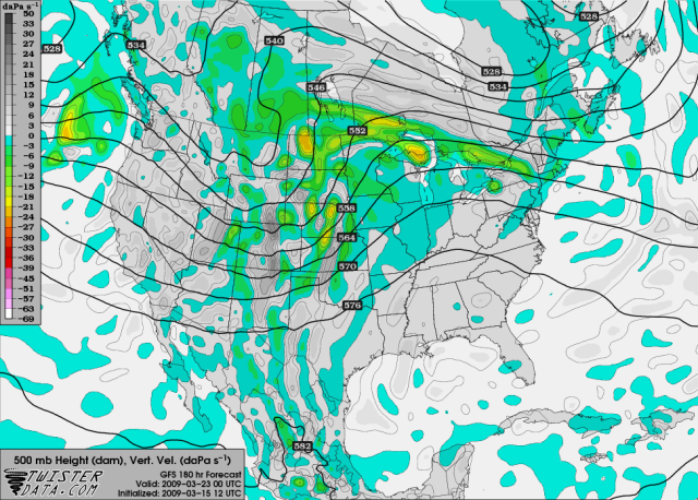
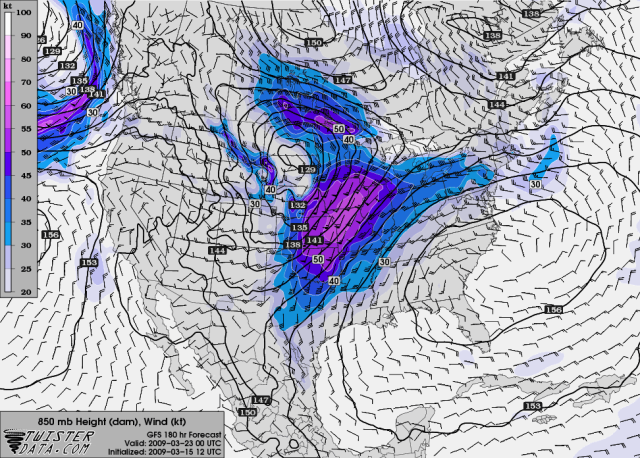
This is Saturday evening
500mb winds

850mb winds

Dew points upper 50's ahead of the front.

Instability not too good though

0 likes
-
Ed Mahmoud
Re:
RL3AO wrote:If the long range GFS is right, the next week or two could be...slow to say the least severe weather rise.
It isn't even the middle of March yet.
Not too unusual. April and May is the busy season around these parts, and the places that often do see severe weather in late Winter, like the Gulf Coast, they may be missing the rain, but not the tornadoes, I'm sure.
0 likes
-
Ed Mahmoud
Re: 2009 Severe Weather thread
4 to 8 day outlook today suggested long range models suggest quite tranquil until just beyond Day 8, then more interesting and Spring like weather.
Maybe a week from Monday?


Maybe a week from Monday?
0 likes
-
Meso

- Category 5

- Posts: 1609
- Age: 39
- Joined: Mon Aug 09, 2004 12:14 pm
- Location: South Africa
- Contact:
Re: 2009 Severe Weather thread
The models do seem to be onto a weather pattern change around 8 days from now.. The GFS was pretty aggressive with a low on the 00z run.. Something may happen in about a week,well for the chasers I hope it does.
0 likes
-
Ed Mahmoud
Re:
CrazyC83 wrote:Those quick-movers tend to be conducive to tornadic activity?
I think it depends, if the frequency of deep frontal penetrations is too high, quality return moisture and instability becomes somewhat limited, especially if the storms track through the mid-Plains. Texas and Oklahoma may have sufficient moisture, but are too far from the jet dynamics, Kansas and Missouri and points North have the jet dynamics, but are lacking instability.
0 likes
-
Ed Mahmoud
Re: 2009 Severe Weather thread
1 week away?
No Gulf intrusions per Euro for several days, and about 2 full days of return flow to the Plains.
Looks interesting from extreme North Texas to the maybe South Dakota and states alongside. Warm front looks to be in Kansas or Nebraska, probably ground zero, if the Euro is correct.


No Gulf intrusions per Euro for several days, and about 2 full days of return flow to the Plains.
Looks interesting from extreme North Texas to the maybe South Dakota and states alongside. Warm front looks to be in Kansas or Nebraska, probably ground zero, if the Euro is correct.
0 likes

-
srainhoutx

- S2K Supporter

- Posts: 6919
- Age: 68
- Joined: Sun Jan 14, 2007 11:34 am
- Location: Haywood County, NC
- Contact:
Re: 2009 Severe Weather thread
Ed Mahmoud wrote:1 week away?
No Gulf intrusions per Euro for several days, and about 2 full days of return flow to the Plains.
Looks interesting from extreme North Texas to the maybe South Dakota and states alongside. Warm front looks to be in Kansas or Nebraska, probably ground zero, if the Euro is correct.
Be careful Ed. HPC suspects errors with the ECMWF...
PRELIMINARY EXTENDED FORECAST DISCUSSION
NWS HYDROMETEOROLOGICAL PREDICTION CENTER CAMP SPRINGS MD
844 AM EDT MON MAR 16 2009
VALID 12Z FRI MAR 20 2009 - 12Z MON MAR 23 2009
...00Z ECMWF ENSEMBLE MEAN AND 00Z CANADIAN/ECMWF ENSEMBLE 500 HPA
HEIGHT SPAGHETTIS AND SURFACE LOW POSITIONS UNAVAILABLE FOR THIS
DISCUSSION...
TELECONNECTIONS WITH A RELATIVELY STABLE POSITIVE ANOMALY SOUTH OF
THE UPPER ALEUTIANS TELECONNECTS TO MODEST TROUGHING OFFSHORE THE
WEST COAST AS WELL AS EASTERN CANADA...A POLAR VORTEX IN
NUNAVUT...ALONG WITH A SOUTHERN STREAM MOVING THROUGH NORTHWEST
MEXICO. THIS IDEA IS REFLECTIVE IN THE LATEST 06Z GFS/00Z AND 06Z
GEFS ENSEMBLE MEAN SOLUTIONS. THE 00Z ECMWF/00Z CANADIAN
SOLUTIONS ARE INTERESTING CONCERNING THEIR SIGNIFICANT
AMPLIFICATION AND STREAM PHASING ACROSS NORTH AMERICA.
INTERNALLY...THE CANADIAN AMPLIFICATION MAKES SOME SENSE...THOUGH
IT DOES NOT MATCH WELL WITH THE 00Z/06Z GEFS ENSEMBLE MEAN
SOLUTIONS ACROSS THE NORTHEAST PACIFIC WHICH IS PROBLEMATIC. IN
THE CASE OF THE 00Z ECMWF...IT MANAGES TO AMPLIFY THE FLOW PATTERN
AROUND NORTH AMERICA WHILE AN INCREASINGLY ZONAL FLOW REGIME
BECOMES ESTABLISHED ACROSS THE EASTERN PACIFIC...A SOLUTION WHICH
DOES NOT MAKE MUCH SENSE. FOUR TO FIVE DAYS AGO THE ECMWF TRIED A
SIMILAR AMPLIFICATION TO THE FLOW REGIME...ONLY TO BACK OFF AFTER
ONE OR TWO RUNS. IT IS UNCLEAR IF THESE PROBLEMS ARE RELATED TO
CHANGES MADE IN THE ECMWF MODEL LAST WEEK. SINCE THE POORLY
PERFORMING 00Z CANADIAN SUPPORTS THE 00Z ECMWF...WILL CONSIDER
THEIR SOLUTION A LOW PROBABILITY ALTERNATIVE SCENARIO /WHICH WOULD
HAVE SERVED US WELL WITH THE FORECAST ISSUED BY HPC FEBRUARY 24/.
IN ANY CASE...A 06Z GFS/06Z GEFS MEAN COMPROMISE WAS USED THROUGH
THE PERIOD...EXCEPT FOR EARLY THURSDAY WHEN THE 00Z ECMWF WAS
DEEMED MORE USABLE. THIS SOLUTION KEPT GOOD CONTINUITY WITH NIGHT
SHIFT PRESSURE-WISE INTO THIS WEEKEND...BEFORE SPEEDING UP
CYCLONE/FRONTAL PROGRESSION BY NEXT MONDAY ACROSS THE
INTERMOUNTAIN WEST AND GREAT PLAINS...BUT HAS GREATER
REPERCUSSIONS IN THE ANTICIPATED TEMPERATURE PATTERN.
ROTH
0 likes
Return to “USA & Caribbean Weather”
Who is online
Users browsing this forum: wxman22 and 114 guests