YES!!! Finally rain moving into Saint Petersburg off the Gulf
of Mexico!! Moderate to light but still HECK YEA!!!!!!
http://radar.weather.gov/ridge/radar.ph ... 1&loop=yes
Florida Weather
Moderator: S2k Moderators
Forum rules

The posts in this forum are NOT official forecast and should not be used as such. They are just the opinion of the poster and may or may not be backed by sound meteorological data. They are NOT endorsed by any professional institution or STORM2K.
-
Tampa Bay Hurricane

- Category 5

- Posts: 5597
- Age: 38
- Joined: Fri Jul 22, 2005 7:54 pm
- Location: St. Petersburg, FL
-
Tampa Bay Hurricane
- Category 5
- Posts: 5597
- Age: 38
- Joined: Fri Jul 22, 2005 7:54 pm
- Location: St. Petersburg, FL
-
gatorcane

- S2K Supporter

- Posts: 23708
- Age: 48
- Joined: Sun Mar 13, 2005 3:54 pm
- Location: Boca Raton, FL
Re: Florida Weather Thread: Cold front brings needed rain
Quite a different forecast from NWS Tampa vs. NWS Miami with NWS Tampa more gunhoe on much needed rainfall for even South Central Florida: NWS Miami thinks the event is pretty much over. I will go with NWS Miami on my thinking.
NWS Tampa:
.DISCUSSION...LINGERING MID LEVEL TROUGH AND REMNANT FRONTAL BOUNDARY
OVER THE SOUTHERN PENINSULA COMBINED WITH DAYTIME HEATING AND LOCAL
SEA BREEZE BOUNDARY CONVERGENCE WILL BE THE FOCUS FOR SOME SHOWERS
ACROSS MY CENTRAL AND SOUTHERN MOST ZONES DURING THIS AFTERNOON. AFTER
LOOKING OVER 12Z RAOB DATA AM A BIT CONCERNED ABOUT THE POSSIBILITY
OF SOME THUNDERSTORMS AS WELL...WITH SOME POSSIBLY STRONG. CURRENT
RAOB DATA SHOWS RATHER COLD TEMPERATURES ALOFT (-15C/-29C AT 500MB/400MB)
AND THESE COLD TEMPS COMBINED WITH DAYTIME HEATING WILL HELP TO STEEPEN
LAPSE RATES. THIS COMBINED WITH THE ADDED SEA BREEZE CONVERGENCE MAY
BE ENOUGH TO BREAK THE CAP ~680MB AND ALLOW T-STORMS TO FIRE OFF. WITH
THE COLD TEMPS ALOFT AND LOW WET-BULB ZERO LEVELS ANY T-STORM THAT DOES
DEVELOP WILL BE CAPABLE OF PRODUCING HAIL AND OR STRONG GUSTY WINDS.
NWS Miami:
.UPDATE...OBSERVATIONAL TRENDS SUGGEST THAT SUBSIDENCE ON THE BACK
SIDE OF THE SHORTWAVE TROUGH IS IMPINGING INTO THE AREA AT THIS
TIME WITH RAINFALL COVERAGE/INTENSITY ON THE DECREASE OVER
LAND...WITH HEAVIEST ACTIVITY SHUNTED EAST OVER THE ATLANTIC.
BELIEVE THIS WILL CONTINUE TO BE THE TREND TODAY AS WATER VAPOR
IMAGERY SHOWS THAT AXIS OF THE SHORTWAVE WILL BE EAST OF THE AREA
DURING MAX DAYTIME HEATING. ALSO...SURFACE TROUGH IS ALIGNED FROM
THE KEYS NE INTO THE ATLANTIC AND THIS WILL MOVE SE. SO DESPITE A
MORE UNSTABLE ENVIRONMENT TODAY AS EVIDENCED BY THE MIAMI SOUNDING
AND SURROUNDING SOUNDINGS...BELIEVE TODAY WILL BE MUCH LESS ACTIVE
COMPARED TO YESTERDAY. WILL DECREASE POPS ACROSS THE BOARD FOR
THIS REASON. GIVEN THE INSTABILITY PRESENT...WILL MAINTAIN SLIGHT
CHC TSTORMS AREA WIDE THROUGH. /DG
0 likes
-
Evil Jeremy

- S2K Supporter
- Posts: 5463
- Age: 32
- Joined: Mon Apr 10, 2006 2:10 pm
- Location: Los Angeles, CA
Re: Florida Weather Thread: Cold front brings needed rain
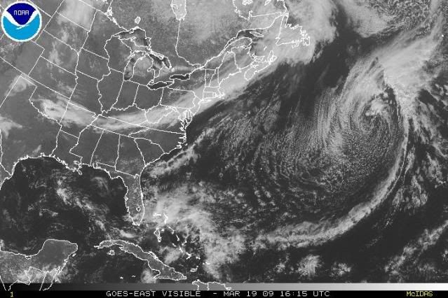
It is interesting comparing the Graphicasts from the Tampa and Miami offices. Anyways, it has not rained much today, and the rain seems to be dieing down.
BTW, if it was hurricane season, I think the low pressure front off the coast now would be an invest lol.
BTW, if it was hurricane season, I think the low pressure front off the coast now would be an invest lol.
0 likes
-
HURAKAN

- Professional-Met

- Posts: 46084
- Age: 39
- Joined: Thu May 20, 2004 4:34 pm
- Location: Key West, FL
- Contact:
Re: Florida Weather Thread: Cold front brings needed rain
Pompano Beach received 6.05 inches of rain in the last 24 hours! WOW!!!
lINK: http://www.weather.gov/climate/getclimate.php?wfo=mfl
lINK: http://www.weather.gov/climate/getclimate.php?wfo=mfl
0 likes
-
HURAKAN
- Professional-Met
- Posts: 46084
- Age: 39
- Joined: Thu May 20, 2004 4:34 pm
- Location: Key West, FL
- Contact:
Re: Florida Weather Thread: Cold front brings needed rain
Evil Jeremy wrote:BTW, if it was hurricane season, I think the low pressure front off the coast now would be an invest lol.
Correct!

0 likes
Re: Florida Weather Thread: Cold front brings needed rain
Drier conditions working their way into South Florida....12pm observations
WEST PALM BEACH PTSUNNY 74
FT LAUDERDALE PTSUNNY 73
POMPANO BEACH PTSUNNY 72
PEMBROKE PINES PTSUNNY 71
OPA LOCKA CLOUDY 74
MIAMI PTSUNNY 75
WEST KENDALL MOSUNNY 77
HOMESTEAD PTSUNNY 75
WEST PALM BEACH PTSUNNY 74
FT LAUDERDALE PTSUNNY 73
POMPANO BEACH PTSUNNY 72
PEMBROKE PINES PTSUNNY 71
OPA LOCKA CLOUDY 74
MIAMI PTSUNNY 75
WEST KENDALL MOSUNNY 77
HOMESTEAD PTSUNNY 75
0 likes
-
HURRICANELONNY
- Category 5
- Posts: 1390
- Joined: Wed May 07, 2003 6:48 am
- Location: HOLLYWOOD.FL
Re: Florida Weather Thread: Cold front brings needed rain
As of this morning there was a 90% chance of rain for Broward today. It only pours when there is a 40% chance. 
0 likes
-
Tampa Bay Hurricane
- Category 5
- Posts: 5597
- Age: 38
- Joined: Fri Jul 22, 2005 7:54 pm
- Location: St. Petersburg, FL
Re: Florida Weather Thread: Cold front brings needed rain
gatorcane wrote:Quite a different forecast from NWS Tampa vs. NWS Miami with NWS Tampa more gunhoe on much needed rainfall for even South Central Florida: NWS Miami thinks the event is pretty much over. I will go with NWS Miami on my thinking.
NWS Tampa:
.DISCUSSION...LINGERING MID LEVEL TROUGH AND REMNANT FRONTAL BOUNDARY
OVER THE SOUTHERN PENINSULA COMBINED WITH DAYTIME HEATING AND LOCAL
SEA BREEZE BOUNDARY CONVERGENCE WILL BE THE FOCUS FOR SOME SHOWERS
ACROSS MY CENTRAL AND SOUTHERN MOST ZONES DURING THIS AFTERNOON. AFTER
LOOKING OVER 12Z RAOB DATA AM A BIT CONCERNED ABOUT THE POSSIBILITY
OF SOME THUNDERSTORMS AS WELL...WITH SOME POSSIBLY STRONG. CURRENT
RAOB DATA SHOWS RATHER COLD TEMPERATURES ALOFT (-15C/-29C AT 500MB/400MB)
AND THESE COLD TEMPS COMBINED WITH DAYTIME HEATING WILL HELP TO STEEPEN
LAPSE RATES. THIS COMBINED WITH THE ADDED SEA BREEZE CONVERGENCE MAY
BE ENOUGH TO BREAK THE CAP ~680MB AND ALLOW T-STORMS TO FIRE OFF. WITH
THE COLD TEMPS ALOFT AND LOW WET-BULB ZERO LEVELS ANY T-STORM THAT DOES
DEVELOP WILL BE CAPABLE OF PRODUCING HAIL AND OR STRONG GUSTY WINDS.
NWS Miami:
.UPDATE...OBSERVATIONAL TRENDS SUGGEST THAT SUBSIDENCE ON THE BACK
SIDE OF THE SHORTWAVE TROUGH IS IMPINGING INTO THE AREA AT THIS
TIME WITH RAINFALL COVERAGE/INTENSITY ON THE DECREASE OVER
LAND...WITH HEAVIEST ACTIVITY SHUNTED EAST OVER THE ATLANTIC.
BELIEVE THIS WILL CONTINUE TO BE THE TREND TODAY AS WATER VAPOR
IMAGERY SHOWS THAT AXIS OF THE SHORTWAVE WILL BE EAST OF THE AREA
DURING MAX DAYTIME HEATING. ALSO...SURFACE TROUGH IS ALIGNED FROM
THE KEYS NE INTO THE ATLANTIC AND THIS WILL MOVE SE. SO DESPITE A
MORE UNSTABLE ENVIRONMENT TODAY AS EVIDENCED BY THE MIAMI SOUNDING
AND SURROUNDING SOUNDINGS...BELIEVE TODAY WILL BE MUCH LESS ACTIVE
COMPARED TO YESTERDAY. WILL DECREASE POPS ACROSS THE BOARD FOR
THIS REASON. GIVEN THE INSTABILITY PRESENT...WILL MAINTAIN SLIGHT
CHC TSTORMS AREA WIDE THROUGH. /DG
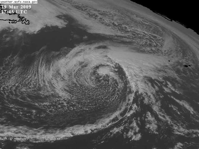
I HOPE NWS TAMPA is right! I want to see some BIG STORMS!!! THAT WOULD TOTALLY
ROCK!!!!!!!!
AND I LOVE how the circulation off the east coast looks like a tropical
low even though it isn't!!! Adds some hope to the thrillseeker!!!
0 likes
-
HURRICANELONNY
- Category 5
- Posts: 1390
- Joined: Wed May 07, 2003 6:48 am
- Location: HOLLYWOOD.FL
-
HURAKAN
- Professional-Met
- Posts: 46084
- Age: 39
- Joined: Thu May 20, 2004 4:34 pm
- Location: Key West, FL
- Contact:
Re: Florida Weather Thread: Cold front brings needed rain
Before Cold Front:
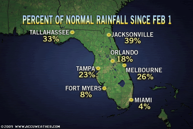
After Cold Front:

Miami went from the driest to the wettest.
After Cold Front:
Miami went from the driest to the wettest.
0 likes
Re: Florida Weather Thread: Cold front brings needed rain
Just as conditions improve some in se fl coastal areas (although clearly overall, south florida is not 'in the clear' from fire threat), the area of 700 kbdi readings is expanding to the north and south of the I-4 corridor fairly rapidly...

0 likes
-
gatorcane
- S2K Supporter
- Posts: 23708
- Age: 48
- Joined: Sun Mar 13, 2005 3:54 pm
- Location: Boca Raton, FL
jintfl, so yes, I do agree South Florida is not in the "all clear" but this rain was certainly unexpected an very beneficial.
The key will be when the rainy season starts this year. Here is a link which provides the meteorological discussion of what exactly denotes the start of the rainy season. Note that the rainy season has started as early as mid April and has started as late as early June.
http://www.srh.noaa.gov/mfl/newpage/summer_season.html
Again, I do think that South Florida is going to be under a long-wave pattern featuring SW windflow that will bring the big storms from the interior eastward to the coast each afternoon. That pattern will largely dominate in May and in some of June as well. Of course we'll see some breaks here and there with good Western Atlantic ridging that will form occasionally bringing in a deep easterly windflow (and AM showers along the SE Coast metro areas) but the east wind pattern is going to wait to setup this year in August it looks like where we should see a few good tropical waves that will enhance the moisture even further.
0 likes
-
gatorcane
- S2K Supporter
- Posts: 23708
- Age: 48
- Joined: Sun Mar 13, 2005 3:54 pm
- Location: Boca Raton, FL
Re: Florida Weather Thread: Cold front brings needed rain
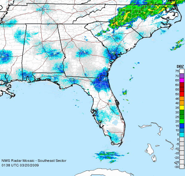
I want to check rainfall on radar in south florida but the NWS Miami radar down again.
Seems that everytime it rains it goes down.
Seems that everytime it rains it goes down.
0 likes
-
Cookiely

- S2K Supporter
- Posts: 3211
- Age: 75
- Joined: Fri Aug 13, 2004 7:31 am
- Location: Tampa, Florida
Re: Florida Weather Thread: Cold front brings needed rain
Newest water restrictions for Tampa due to drought.
No more automatic sprinkler use to water lawns. Hand watering only once a week.
http://www.tampagov.net/dept_water/file ... ummary.pdf
Thats one way to help the coffers of the city of Tampa. One hundred to Four hundred and fifty dollar fines for using sprinklers.
No more automatic sprinkler use to water lawns. Hand watering only once a week.
http://www.tampagov.net/dept_water/file ... ummary.pdf
Thats one way to help the coffers of the city of Tampa. One hundred to Four hundred and fifty dollar fines for using sprinklers.
0 likes
-
JonathanBelles
- Professional-Met
- Posts: 11430
- Age: 35
- Joined: Sat Dec 24, 2005 9:00 pm
- Location: School: Florida State University (Tallahassee, FL) Home: St. Petersburg, Florida
- Contact:
-
gatorcane
- S2K Supporter
- Posts: 23708
- Age: 48
- Joined: Sun Mar 13, 2005 3:54 pm
- Location: Boca Raton, FL
Re: Florida Weather Thread: Cold front brings needed rain
I do feel for you up in the Tampa area and West Central Florida. I used to live there and I remember it seemed each year got drier and drier and colder in the winters (anything below 60F for me is cold). As a palm tree and tropical foliage lover, some of the reason why I moved was because I wanted to head towards a climate that was warmer and more moist and that was less susceptible to freezes that would kill tropical palms. I have several large Malaysian Dwarf coconut palms and some smaller royal palms that need lots or rain and warmth to thrive. Those conditions just don't exist in West Central Florida, unless you live in extreme microclimates of the barrier islands.
I think we could even argue a climate change has happened for the Tampa area with less rainfall than what used to fall years ago back in the 1950s and 1960s. To me, there is really no end in sight for the lack of rainfall in West Central Florida and I expect the drought to continue well into June. The pattern does not look to be favorable for thunderstorm and shower development at least for the next several months and into the first several weeks of the rainy season.
The pattern is likely going to favor the east side of Florida particularly Southern Florida where up to 7 inches of rain has already fallen in some isolated locations (unfortunately not my location, where I have only seen about .75 inches of rain) and the extended forecast shows a chance everyday for the next several days with a 40% chance over the weekend as strong E to ENE winds (up to 30mph gusts) blow in over the warm Gulf stream current.
0 likes
Return to “USA & Caribbean Weather”
Who is online
Users browsing this forum: No registered users and 32 guests