Severe weather outbreak? March 23-24 - Plains/Midwest
Moderator: S2k Moderators
Forum rules

The posts in this forum are NOT official forecast and should not be used as such. They are just the opinion of the poster and may or may not be backed by sound meteorological data. They are NOT endorsed by any professional institution or STORM2K.
-
CrazyC83
- Professional-Met

- Posts: 34315
- Joined: Tue Mar 07, 2006 11:57 pm
- Location: Deep South, for the first time!
Severe weather outbreak? March 23-24 - Plains/Midwest
I just noticed the SPC has highlighted a large area for March 23 (Day 6), which this early means that there is pretty good confidence. It definitely looks like something big might happen.
0 likes

-
srainhoutx

- S2K Supporter

- Posts: 6919
- Age: 68
- Joined: Sun Jan 14, 2007 11:34 am
- Location: Haywood County, NC
- Contact:
Re: Severe weather outbreak? March 23-24 - Plains/Midwest
One thing that is catching my attention is that models have trended slower with the trough moving E which would allow for higher dew points and a good return of southerly flow ahead of the disturbance. WFO's in TX are now mentioning severe possibilities as well. I would not be surprised to see this area expanded in the days ahead by SPC if model guidance continues slower...
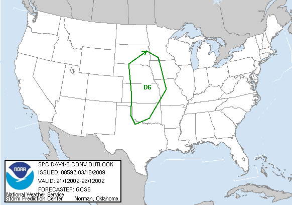
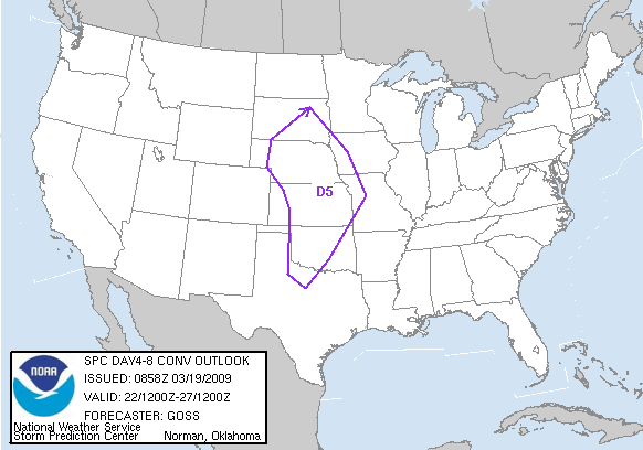
DAY 4-8 CONVECTIVE OUTLOOK
NWS STORM PREDICTION CENTER NORMAN OK
0359 AM CDT WED MAR 18 2009
VALID 211200Z - 261200Z
...DISCUSSION...
MODEL DIFFERENCES CONTINUE THIS PERIOD...PARTICULARLY BEYOND DAY 6
/MON. 3-23/...WITH THE GFS REMAINING MORE PROGRESSIVE WITH THE
EJECTION OF THE WRN U.S. TROUGH.
THE GFS EJECTS THE UPPER TROUGH INTO THE PLAINS DAY 6...AND THEN
INTO THE N CENTRAL CONUS DAY 7. WHILE THE ECMWF ALSO EJECTS A PIECE
OF THE TROUGH INTO THE PLAINS DAY 6...THE LARGER-SCALE TROUGH LAGS
WWD...AS A SECOND/SMALLER-SCALE TROUGH DIGS SEWD ACROSS THE DESERT
SW AS THE INITIAL FEATURE SHIFTS INTO THE PLAINS. THUS -- DUE TO
THESE MODEL DIFFERENCES...CONFIDENCE IN EVOLUTION OF THE SEVERE
THREAT DIMINISHES AFTER DAY 6.
FOR DAY 6 HOWEVER...IT APPEARS THAT A LOW/COLD FRONT WILL CROSS THE
PLAINS AHEAD OF A SUBSTANTIAL/EJECTING UPPER FEATURE. WITH SEVERAL
PRIOR DAYS OF SLY LOW-LEVEL FLOW OFF AN OPEN GULF...THERMODYNAMIC
ENVIRONMENT SHOULD BE SUFFICIENT -- GIVEN ANTICIPATED STRENGTH OF
FLOW ALOFT -- TO SUPPORT THE POTENTIAL FOR A WIDESPREAD SEVERE
WEATHER EPISODE. THUS...WILL INTRODUCE A THREAT AREA DAY 6.
..GOSS.. 03/18/2009
0 likes

Re: Severe weather outbreak? March 23-24 - Plains/Midwest
12z GFS for Monday evening (0z Tuesday)
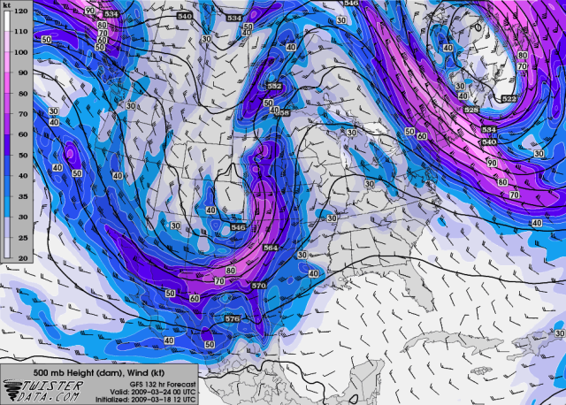
One thing that will need to be watched is how high the temp/dewpoint can get. After all, it is March and you won't have mid-70's dewpoints.
One thing that will need to be watched is how high the temp/dewpoint can get. After all, it is March and you won't have mid-70's dewpoints.
Last edited by RL3AO on Wed Mar 18, 2009 2:29 pm, edited 1 time in total.
0 likes
-
srainhoutx
- S2K Supporter
- Posts: 6919
- Age: 68
- Joined: Sun Jan 14, 2007 11:34 am
- Location: Haywood County, NC
- Contact:
Re: Severe weather outbreak? March 23-24 - Plains/Midwest
DAY 4-8 CONVECTIVE OUTLOOK
NWS STORM PREDICTION CENTER NORMAN OK
0358 AM CDT THU MAR 19 2009
VALID 221200Z - 271200Z
...DISCUSSION...
A SEVERE EVENT REMAINS APPARENT FOR MON. MAR. 23 /DAY 5/...WITH
MEDIUM-RANGE MODELS CONTINUING TO FORECAST A MID-LEVEL LOW SHIFTING
EWD OUT OF THE ROCKIES AND ACROSS THE CENTRAL HIGH PLAINS THROUGH
THE AFTERNOON. WITH A FAIRLY BROAD/RELATIVELY MOIST BOUNDARY LAYER
FORECAST TO BE IN PLACE AHEAD OF A SURFACE CYCLONE LIKELY CENTERED
OVER THE CENTRAL HIGH PLAINS DURING THE AFTERNOON...SETUP APPEARS TO
FAVOR WIDESPREAD THUNDERSTORM DEVELOPMENT.
WHILE SOMEWHAT MERIDIONAL -- PARTICULARLY OVER THE CENTRAL
PLAINS...WIND FIELD WILL BE PLENTY STRONG TO SUPPORT
SEVERE/SUPERCELL STORMS -- AND THUS ATTM IT CONTINUES TO APPEAR THAT
A FAIRLY WIDESPREAD SEVERE EVENT IS LIKELY.
BEYOND DAY 5 -- AND PARTICULARLY BEYOND DAY 6...MODELS BEGIN TO
DIVERGE IN POSITION OF THE MAIN FEATURES...WHICH CASTS UNCERTAINTY
INTO THE SEVERE FORECAST. HOWEVER...EVEN GIVEN MODEL
DIFFERENCES...IT APPEARS ATTM THAT THE PRIMARY SEVERE THREAT WOULD
OCCUR DAY 5...WITH DECREASING POTENTIAL FARTHER E INTO THE MID MO
VALLEY REGION FOR DAY 6.
..GOSS.. 03/19/2009
0 likes
-
Extremeweatherguy

- Category 5

- Posts: 11095
- Joined: Mon Oct 10, 2005 8:13 pm
- Location: Florida
Re: Severe weather outbreak? March 23-24 - Plains/Midwest
Looks very interesting. Next Monday might wind up being a pretty active day around these parts.
0 likes
Tomorrow the NAM will be in range for Mondays event, but looking at the GFS and NAM for Sunday evening, the NAM has it a full 5 to 10 degrees warmer over the Plains than the GFS. The dewpoints are about the same, but lets see what it shows for Monday tomorrow. The GFS has been underestimating instability so far this year if I remember right.
0 likes
-
CrazyC83
- Professional-Met
- Posts: 34315
- Joined: Tue Mar 07, 2006 11:57 pm
- Location: Deep South, for the first time!
Re:
RL3AO wrote:Tomorrow the NAM will be in range for Mondays event, but looking at the GFS and NAM for Sunday evening, the NAM has it a full 5 to 10 degrees warmer over the Plains than the GFS. The dewpoints are about the same, but lets see what it shows for Monday tomorrow. The GFS has been underestimating instability so far this year if I remember right.
If that is the case, then this could be HUGE.
0 likes

Re: Severe weather outbreak? March 23-24 - Plains/Midwest
DAY 4-8 CONVECTIVE OUTLOOK
NWS STORM PREDICTION CENTER NORMAN OK
0328 AM CDT FRI MAR 20 2009
VALID 231200Z - 281200Z
...DISCUSSION...
LATEST MEDIUM-RANGE GUIDANCE REMAINS IN REMARKABLY GOOD AGREEMENT IN
THE EVOLUTION OF A POWERFUL SYNOPTIC SYSTEM OVER THE CNTRL U.S. ON
D4 /MON MAR 23RD/. ALOFT...AN INTENSE MID/UPPER-LEVEL LOW WILL
SHIFT EWD FROM THE CNTRL ROCKIES INTO THE CNTRL PLAINS WHILE AN
ASSOCIATED SURFACE CYCLONE DEVELOPS FROM THE CNTRL HIGH PLAINS NEWD
INTO THE CNTRL PLAINS BEFORE OCCLUDING. BOUNDARY LAYER MOISTURE
QUALITY STILL APPEARS SOMEWHAT QUESTIONABLE WITH DEWPOINTS REMAINING
LARGELY IN THE 50S. HOWEVER...THE PRESENCE OF STEEP LAPSE
RATES...STRONG DYNAMIC FORCING AND STRENGTHENING WIND FIELDS WILL
LIKELY FOSTER NUMEROUS SEVERE STORMS /INCLUDING SUPERCELLS/ ALONG OR
AHEAD OF DRYLINE OR PACIFIC FRONT OVER THE CNTRL AND SRN PLAINS.
BOUNDARY LAYER MOISTURE IS EXPECTED TO IMPROVE AHEAD OF PACIFIC
FRONT OVER LOWER ELEVATIONS OF THE SRN PLAINS INTO OZARK PLATEAU BY
D5 /TUE MAR 24TH/. WHILE PRIMARY UPPER LOW/VORTICITY MAXIMUM AND
ASSOCIATED SURFACE LOW ARE FORECAST TO DEVELOP NEWD TOWARD THE UPPER
MIDWEST...MODEL GUIDANCE SUGGESTS A SECONDARY VORTICITY MAXIMUM/JET
STREAK ROTATING THROUGH THE LARGE-SCALE TROUGH BASE OVER THE SRN
PLAINS. GIVEN THE INCREASING MOISTURE/INSTABILITY AND CONTINUED
STRONG WIND FIELDS...POTENTIAL WILL EXIST FOR ANOTHER ORGANIZED
SEVERE WEATHER EPISODE FROM ERN PARTS OF OK/TX INTO PORTIONS OF AR
AND PERHAPS SRN MO AND NRN LA.
THEREAFTER...MODEL DIFFERENCES BEGIN TO ARISE IN THE EVOLUTION OF
THE UPPER-LEVEL PATTERN. MOREOVER...CONSIDERABLE TSTM ACTIVITY OVER
THE PREVIOUS TWO DAYS MAY POTENTIALLY DISPLACE THE EFFECTIVE WARM
SECTOR FURTHER TO THE S/SE THAN WHAT CURRENT GUIDANCE INDICATES.
NONETHELESS...IT DOES APPEAR THAT MODERATELY STRONG WIND FIELDS WILL
BE MAINTAINED ACROSS THE GULF COAST REGION IN CLOSE PROXIMITY TO A
MOIST AND UNSTABLE AIR MASS. AS SUCH...THE POTENTIAL FOR SEVERE
WEATHER WILL LIKELY CONTINUE THROUGH THE REMAINDER OF THE EXTENDED
PERIOD. HOWEVER...GIVEN THE UNCERTAINTY IN THE DETAILS...NO
ADDITIONAL SEVERE WEATHER AREAS WILL BE DELINEATED ATTM.
0 likes
-
srainhoutx
- S2K Supporter
- Posts: 6919
- Age: 68
- Joined: Sun Jan 14, 2007 11:34 am
- Location: Haywood County, NC
- Contact:
Re: Severe weather outbreak? March 23-24 - Plains/Midwest
arlwx wrote:DAY 4-8 CONVECTIVE OUTLOOK
NWS STORM PREDICTION CENTER NORMAN OK
0328 AM CDT FRI MAR 20 2009
VALID 231200Z - 281200Z
...DISCUSSION...
LATEST MEDIUM-RANGE GUIDANCE REMAINS IN REMARKABLY GOOD AGREEMENT IN
THE EVOLUTION OF A POWERFUL SYNOPTIC SYSTEM OVER THE CNTRL U.S. ON
D4 /MON MAR 23RD/. ALOFT...AN INTENSE MID/UPPER-LEVEL LOW WILL
SHIFT EWD FROM THE CNTRL ROCKIES INTO THE CNTRL PLAINS WHILE AN
ASSOCIATED SURFACE CYCLONE DEVELOPS FROM THE CNTRL HIGH PLAINS NEWD
INTO THE CNTRL PLAINS BEFORE OCCLUDING. BOUNDARY LAYER MOISTURE
QUALITY STILL APPEARS SOMEWHAT QUESTIONABLE WITH DEWPOINTS REMAINING
LARGELY IN THE 50S. HOWEVER...THE PRESENCE OF STEEP LAPSE
RATES...STRONG DYNAMIC FORCING AND STRENGTHENING WIND FIELDS WILL
LIKELY FOSTER NUMEROUS SEVERE STORMS /INCLUDING SUPERCELLS/ ALONG OR
AHEAD OF DRYLINE OR PACIFIC FRONT OVER THE CNTRL AND SRN PLAINS.
BOUNDARY LAYER MOISTURE IS EXPECTED TO IMPROVE AHEAD OF PACIFIC
FRONT OVER LOWER ELEVATIONS OF THE SRN PLAINS INTO OZARK PLATEAU BY
D5 /TUE MAR 24TH/. WHILE PRIMARY UPPER LOW/VORTICITY MAXIMUM AND
ASSOCIATED SURFACE LOW ARE FORECAST TO DEVELOP NEWD TOWARD THE UPPER
MIDWEST...MODEL GUIDANCE SUGGESTS A SECONDARY VORTICITY MAXIMUM/JET
STREAK ROTATING THROUGH THE LARGE-SCALE TROUGH BASE OVER THE SRN
PLAINS. GIVEN THE INCREASING MOISTURE/INSTABILITY AND CONTINUED
STRONG WIND FIELDS...POTENTIAL WILL EXIST FOR ANOTHER ORGANIZED
SEVERE WEATHER EPISODE FROM ERN PARTS OF OK/TX INTO PORTIONS OF AR
AND PERHAPS SRN MO AND NRN LA.
THEREAFTER...MODEL DIFFERENCES BEGIN TO ARISE IN THE EVOLUTION OF
THE UPPER-LEVEL PATTERN. MOREOVER...CONSIDERABLE TSTM ACTIVITY OVER
THE PREVIOUS TWO DAYS MAY POTENTIALLY DISPLACE THE EFFECTIVE WARM
SECTOR FURTHER TO THE S/SE THAN WHAT CURRENT GUIDANCE INDICATES.
NONETHELESS...IT DOES APPEAR THAT MODERATELY STRONG WIND FIELDS WILL
BE MAINTAINED ACROSS THE GULF COAST REGION IN CLOSE PROXIMITY TO A
MOIST AND UNSTABLE AIR MASS. AS SUCH...THE POTENTIAL FOR SEVERE
WEATHER WILL LIKELY CONTINUE THROUGH THE REMAINDER OF THE EXTENDED
PERIOD. HOWEVER...GIVEN THE UNCERTAINTY IN THE DETAILS...NO
ADDITIONAL SEVERE WEATHER AREAS WILL BE DELINEATED ATTM.
0 likes
-
CrazyC83
- Professional-Met
- Posts: 34315
- Joined: Tue Mar 07, 2006 11:57 pm
- Location: Deep South, for the first time!
Re: Severe weather outbreak? March 23-24 - Plains/Midwest
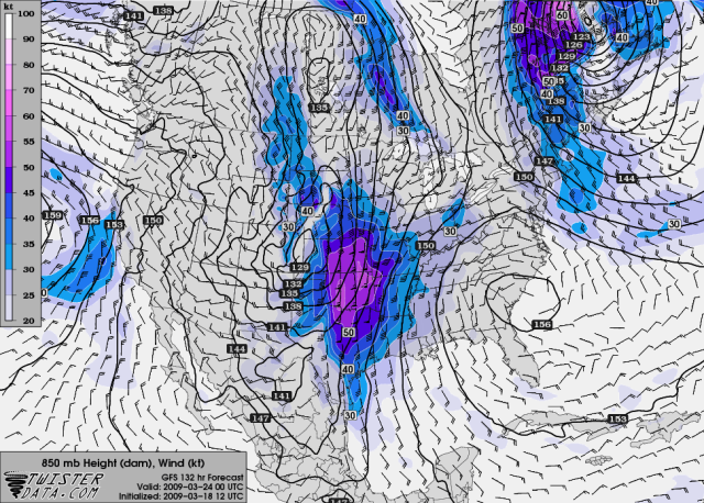
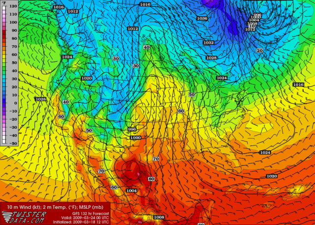
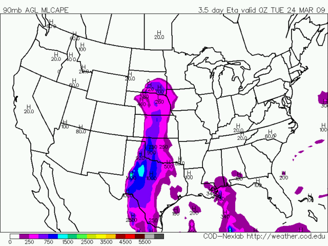
Key data at 0000Z Monday evening:
EHI - peaks around 3.00 in north-central Oklahoma/south-central Kansas with a swath above 2.00 in the region. Otherwise generally around 1.50-1.75.
CAPE - generally around 750-1,000. Interestingly, there is a peak around 1,200 in South Dakota...
Dewpoints - upper 50s. 60 dews only get as far as the Red River but 55 dews get as far as South Dakota.
LI - double peak around -4 in South Dakota and Oklahoma.
Helicity - peaks around 500-600 in Oklahoma.
0 likes
Doesn't seem to be a massive amount of Cape forecasted, generally between 500-750 in the main risk zone but as mentioned by the forecast there is strong dynamic forcing and with a high shear set-up what we have is enough to spawn some tornadoes I'd have thought.
Still have to wait till Monday comes to watch the dew points.
Still have to wait till Monday comes to watch the dew points.
0 likes

-
CrazyC83
- Professional-Met
- Posts: 34315
- Joined: Tue Mar 07, 2006 11:57 pm
- Location: Deep South, for the first time!
Re: Severe weather outbreak? March 23-24 - Plains/Midwest
Latest NAM run has increased things quite a bit (red - more conducive for severe weather, green - less conducive)
EHI - Several areas over 3.00 in Oklahoma and Kansas, with a fairly large area around 1.50.
CAPE - Peaks around 1,500 with a good swath around 1,000 in Oklahoma and southern Kansas.
Dewpoints - Mid to upper 50s as far north as South Dakota, with isolated low 60s in Oklahoma.
LI - Peaks around -8 on the dryline in Kansas and Oklahoma as it advances.
Helicity - Mostly running in the 600-750 range, although it increases to nearly 1,000 in eastern Kansas overnight.
0 likes
-
CrazyC83
- Professional-Met
- Posts: 34315
- Joined: Tue Mar 07, 2006 11:57 pm
- Location: Deep South, for the first time!
Re: Severe weather outbreak? March 23-24 - Plains/Midwest
Most recent run has the following synoptics: (red - more conducive for severe weather than the previous estimate, green - less conducive)
EHI - Peaks around 2.50 in Kansas and Oklahoma.
CAPE - Late evening peak near 1,500, but mostly in the 500-1,000 range.
Dewpoints - Mid to upper 50s for the most part. Isolated dews near 60 in Oklahoma.
LI - Peaks around -6 on the dryline.
Helicity - Mostly running in the 500-750 range, although it increases to nearly 1,000 in eastern Kansas overnight.
Overall, looking a bit less impressive.
0 likes
Return to “USA & Caribbean Weather”
Who is online
Users browsing this forum: No registered users and 138 guests