Coral Sea: JASPER - Tropical Cyclone
Moderator: S2k Moderators


-
HURAKAN

- Professional-Met

- Posts: 46084
- Age: 39
- Joined: Thu May 20, 2004 4:34 pm
- Location: Key West, FL
- Contact:
Australian Government Bureau of Meteorology
Queensland
Tropical Cyclone Warning Centre
Media: This message is issued daily for the information of interested parties.
Media are NOT required to broadcast this message.
TROPICAL CYCLONE OUTLOOK
for the Coral Sea West of Longitude 160 East
Issued at 2:30pm on Sunday the 22nd of March 2009
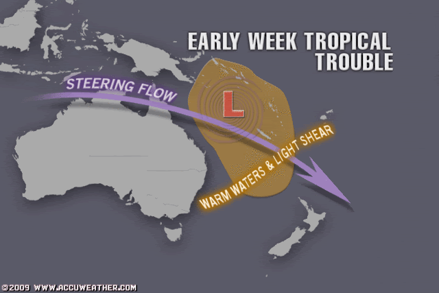
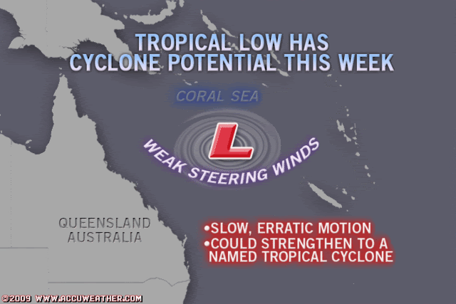
The monsoon trough extends across far northern Cape York Peninsula and the
northern Coral Sea. A low with central pressure approximately 999 hPa lies over
the Coral Sea near 13S 151E. This low is expected to deepen slightly and move
southeast during the next few days.
The probability of this system becoming a tropical cyclone over the next three
days is:
Monday: Low
Tuesday: Moderate
Wednesday: Low
Tropical Cyclone outlooks issued by Brisbane can be accessed through the
Bureau's Home Page http://www.bom.gov.au.
Please note that the Darwin Regional Forecasting Centre issues Tropical Cyclone
Outlooks that cover the Gulf of Carpentaria. Refer to the Northern Region and
Gulf 3 day outlook at http://www.bom.gov.au/weather/cyclone/tc-outlooks.shtml.
Queensland
Tropical Cyclone Warning Centre
Media: This message is issued daily for the information of interested parties.
Media are NOT required to broadcast this message.
TROPICAL CYCLONE OUTLOOK
for the Coral Sea West of Longitude 160 East
Issued at 2:30pm on Sunday the 22nd of March 2009
The monsoon trough extends across far northern Cape York Peninsula and the
northern Coral Sea. A low with central pressure approximately 999 hPa lies over
the Coral Sea near 13S 151E. This low is expected to deepen slightly and move
southeast during the next few days.
The probability of this system becoming a tropical cyclone over the next three
days is:
Monday: Low
Tuesday: Moderate
Wednesday: Low
Tropical Cyclone outlooks issued by Brisbane can be accessed through the
Bureau's Home Page http://www.bom.gov.au.
Please note that the Darwin Regional Forecasting Centre issues Tropical Cyclone
Outlooks that cover the Gulf of Carpentaria. Refer to the Northern Region and
Gulf 3 day outlook at http://www.bom.gov.au/weather/cyclone/tc-outlooks.shtml.
0 likes


-
HURAKAN
- Professional-Met
- Posts: 46084
- Age: 39
- Joined: Thu May 20, 2004 4:34 pm
- Location: Key West, FL
- Contact:
Australian Government Bureau of Meteorology
Queensland
Tropical Cyclone Warning Centre
Media: This message is issued daily for the information of interested parties.
Media are NOT required to broadcast this message.
TROPICAL CYCLONE OUTLOOK
for the Coral Sea West of Longitude 160 East
Issued at 2:43pm on Monday the 23rd of March 2009
The monsoon trough extends across far northern Cape York Peninsula and the
northern Coral Sea. A low with central pressure approximately 1001 hPa lies well
offshore over the Coral Sea near 14.5S 153.5E. This low is expected to deepen
slightly and drift southeast during the next few days.
The probability of this system becoming a tropical cyclone over the next 72
hours is:
0-24 hours: Low
24-48 hours: Moderate
48-72 hours: Moderate
Tropical Cyclone outlooks issued by Brisbane can be accessed through the
Bureau's Home Page http://www.bom.gov.au.
Please note that the Darwin Regional Forecasting Centre issues Tropical Cyclone
Outlooks that cover the Gulf of Carpentaria. Refer to the Northern Region and
Gulf 3 day outlook at http://www.bom.gov.au/weather/cyclone/tc-outlooks.shtml.
0 likes
-
HURAKAN
- Professional-Met
- Posts: 46084
- Age: 39
- Joined: Thu May 20, 2004 4:34 pm
- Location: Key West, FL
- Contact:
Re: Coral Sea: Invest 98P
AN AREA OF CONVECTION HAS PERSISTED NEAR 13.1S 152.7E,
APPROXIMATELY 460 NM EAST-NORTHEAST OF CAIRNS, AUSTRALIA. RECENT
ANIMATED MULTISPECTRAL IMAGERY DEPICTS AN ELONGATED LOW LEVEL
CIRCULATION CENTER (LLCC) WITH PERSISTENT CONVECTION DEVELOPING
ALONG THE PERIPHERY OF THE LLCC. A RECENT QUIKSCAT PASS SUPPORTS THE
CURRENT LOCATION AND INDICATES WINDS AROUND 15 TO 20 KNOTS AROUND
THE LLCC. UPPER LEVEL ANALYSIS INDICATES THE LLCC IS LOCATED
POLEWARD OF A SUBTROPICAL RIDGE IN AN AREA OF DIVERGENCE AND
MODERATE TO HIGH VERTICAL WIND SHEAR. SEA SURFACE TEMPERATURES ARE
VERY FAVORABLE FOR DEVELOPMENT THROUGHOUT THE AREA. MAXIMUM
SUSTAINED SURFACE WINDS ARE ESTIMATED AT 15 TO 20 KNOTS. MINIMUM SEA
LEVEL PRESSURE IS ESTIMATED TO BE NEAR 1001 MB. THE POTENTIAL FOR
THE DEVELOPMENT OF A SIGNIFICANT TROPICAL CYCLONE WITHIN THE NEXT 24
HOURS IS POOR.
0 likes


Who is online
Users browsing this forum: No registered users and 36 guests