Florida Weather
Moderator: S2k Moderators
Forum rules

The posts in this forum are NOT official forecast and should not be used as such. They are just the opinion of the poster and may or may not be backed by sound meteorological data. They are NOT endorsed by any professional institution or STORM2K.
I think tampa bay has the best of both worlds. while our climate isn't as warm as south florida, our hurricane risk seems to be much less. I am perfectly willing to trade a few degrees in the winter for lower cane risk. I have yet to see a truly knockout freeze in the years i've lived here (the worst was jan 2003). Folks who admittedly push the zone with tropicals have largely won. even during this very cold winter we never had a destructive freeze. the foxtails and coconuts have lived to fight another year. this drought is really bad (seems on track to meet or exceed the desert dry of 2000). in the short term, i am very concerned about the fire danger tomorrow. the strong northeast wind combined with tinder dry vegetation and weekend activities (more sources of ignition) has me worried that something is going to be incinerated tomorrow.
0 likes
-
gatorcane

- S2K Supporter

- Posts: 23708
- Age: 48
- Joined: Sun Mar 13, 2005 3:54 pm
- Location: Boca Raton, FL
Re: Florida Weather Thread: Cold front brings needed rain
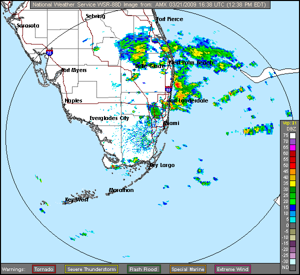
Latest NWS Miami radar is showing some patches of heavy showers moving in from the Atlantic into the East Coast of Florida from about Ft. Pierce south
http://radar.weather.gov/radar.php?rid= ... 1&loop=yes
http://radar.weather.gov/radar.php?rid= ... 1&loop=yes
0 likes

-
gatorcane
- S2K Supporter
- Posts: 23708
- Age: 48
- Joined: Sun Mar 13, 2005 3:54 pm
- Location: Boca Raton, FL
A wind surge is coming in from the Bahamas into Palm Beach County early this afternoon. This wind surge should spread down the SE Coast of Florida into Broward and Miami-Dade later on in the day:
Snippet from NWS Miami:
UPDATE...
NOT MUCH CHANGE TO THE GOING FCST PHILOSOPHY THIS MORNING.
NOCTURNAL LAND BREEZE HAS BROKEN ALONG THE EAST COAST WITH
SCATTERED MODERATE TO HEAVY SHOWERS MOVING SW ONSHORE. THIS TREND
SHOULD CONTINUE THROUGH THE DAY AS NERLY FLOW DEEPENS AND
STRENGTHENS. UPSTREAM...WELL DEFINED WIND SURGE FCST BY MODELS IS
CLEARLY EVIDENT ON VISIBLE SAT IMAGERY FROM NORTH OF THE NORTHERN
BAHAMAS TO THE EAST CENTRAL FL COAST. TIMING OF THIS SURGE MOVING
SW HAS IT ALONG THE NORTHERN PALM BEACH COUNTY COAST EARLY THIS
AFTERNOON. AS THIS SURGE MOVES SOUTH ALONG THE EAST COAST...WINDS
WILL INCREASE SOME THIS AFTERNOON/EVENING AND THERE COULD BE AN
INCREASE IN SHOWER COVERAGE. FOR INTERIOR/GULF COAST
AREAS...ATMOSPHERE APPEARS PRETTY STABLE RIGHT NOW BUT AS THE LAND
MASS HEATS UP AND CONVERGENCE ASSOCIATED WITH THE WIND SURGE
APPROACHES...A FEW SHOWERS WILL LIKELY DEVELOP/SPREAD ACROSS THE
PENINSULA ESPECIALLY THIS AFTERNOON
0 likes
Re: Florida Weather Thread: Cold front brings needed rain
Warm here now. Cold is over. Last trough never got here. Beach weather with SST warming up enough to swim.
0 likes
-
Tampa Bay Hurricane

- Category 5

- Posts: 5597
- Age: 38
- Joined: Fri Jul 22, 2005 7:54 pm
- Location: St. Petersburg, FL
You can see a well-defined frontal low pressure area
near SE Florida just off the coast and moving south:
http://www.ssd.noaa.gov/goes/east/gmex/loop-rb.html
This is enhancing rain in the area.
Also, there are some taller cumulus clouds
crossing Tampa Bay mainly south of MacDill....
they might produce light rain in the next half hour
over NE parts of Saint Petersburg; they are not
very tall, but they are getting thick enough
to drop some sprinkles
0 likes
-
Tampa Bay Hurricane
- Category 5
- Posts: 5597
- Age: 38
- Joined: Fri Jul 22, 2005 7:54 pm
- Location: St. Petersburg, FL
Re: Florida Weather Thread: Cold front brings needed rain
You have to look really hard to find any rain near the
Tampa Bay Area
Isolated moderate showers are moving SW just
south of Polk County and near Sebring, they should move
into Sarasota/Manatee counties before 5 PM. Thicker
clouds over northeast Saint Petersburg may
produce light rain as they converge with a struggling
sea breeze that is pinned over west Pinellas...so
there may be a few showers crossing the beaches by
430 PM or so...
Downtown Saint Pete is missing out on all the action- whatever
little action there is...however there are some darker clouds visible
towards the Gandy Bridge with the convergence of a thin boundary of
clouds moving into Pinellas (east coast sea breeze?) with the west coast seabreeze,
and with the passage of this boundary over my house very close to
Tampa Bay there is a slight surge in the easterly breeze- so perhaps
this is the east coast seabreeze- let's see if SOMETHING can build
up here...
http://radar.weather.gov/ridge/radar.ph ... 1&loop=yes
421 PM EST UPDATE: Sky looking Ominous over northeast Saint Pete, but no rain...but does appear
the seabreeze collision is trying to take place
0 likes
-
Tampa Bay Hurricane
- Category 5
- Posts: 5597
- Age: 38
- Joined: Fri Jul 22, 2005 7:54 pm
- Location: St. Petersburg, FL
-
gatorcane
- S2K Supporter
- Posts: 23708
- Age: 48
- Joined: Sun Mar 13, 2005 3:54 pm
- Location: Boca Raton, FL
Re: Florida Weather Thread: Cold front brings needed rain
Another day of lots of rain for SE FL. Palm Beach County getting lots or rain yet again.
Drought threat for SE FL (Palm Beach, Broward, Miami-Dade) is definitely fading after this week's rainfall...
and the rainy season is yet to come
Drought threat for SE FL (Palm Beach, Broward, Miami-Dade) is definitely fading after this week's rainfall...
and the rainy season is yet to come
0 likes
-
gatorcane
- S2K Supporter
- Posts: 23708
- Age: 48
- Joined: Sun Mar 13, 2005 3:54 pm
- Location: Boca Raton, FL
Re:
Tampa Bay Hurricane wrote:Seabreezes have collided!!! Thick ominous clouds
over north Saint Petersburg and it is sprinkling!
Large moderate showers visible over North Central
Pinellas on radar!
you may squeeze out a sprinkle or too, but this rain event is yet another South Florida event confined to areas From Lake O south. The reason is that the wind surge from building high pressure is blowing over the Gulf Stream current which hugs the SE Coast of FL....this moisture is generally drying out as it heads west across the peninsula.
Extreme drought conditions will continue for the Tampa area and all of West Central Fl.
0 likes
Re:
Tampa Bay Hurricane wrote:Seabreezes have collided!!! Thick ominous clouds
over north Saint Petersburg and it is sprinkling!
Large moderate showers visible over North Central
Pinellas on radar!
When those "sprinkes" coincide with overhead flocks of birds... don't cheer. Big plume of smoke visible earlier from olds park in oldsmar...one of many fires breaking out recently.
0 likes
-
gatorcane
- S2K Supporter
- Posts: 23708
- Age: 48
- Joined: Sun Mar 13, 2005 3:54 pm
- Location: Boca Raton, FL
Re: Florida Weather Thread: Cold front brings needed rain
I remember the spring/summer of 1985 (I think?) It featured widespread fires across West Central FL. At the time, I was living in Palm Harbor off of Curlew. I recall that well into June, things were very dry. I remember looking east towards the area you will typically see afternoon cumulus/cumulonimbus clouds building with the west coast seabreeze interaction with the east wind flow...but all you would see would be huge clouds of smoke, which sometimes were mistaken for actual rain. I'm wondering if this is going to happen again this Spring/Summer?
0 likes
-
gatorcane
- S2K Supporter
- Posts: 23708
- Age: 48
- Joined: Sun Mar 13, 2005 3:54 pm
- Location: Boca Raton, FL
Re: Florida Weather Thread: Cold front brings needed rain
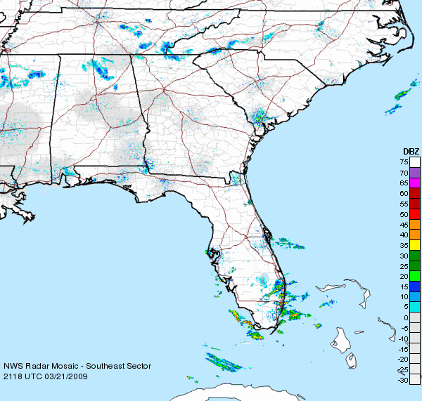
Latest radar out of Miami shows the complete wash-out for the big South Florida counties of Palm Beach, Broward, and Miami-Dade.
The rain chance today was 40% for this CWA, but maybe it should have been about 90% looking at all the rain that continues to fall in South Florida.
http://radar.weather.gov/radar.php?rid= ... 11&loop=no
The rain chance today was 40% for this CWA, but maybe it should have been about 90% looking at all the rain that continues to fall in South Florida.
http://radar.weather.gov/radar.php?rid= ... 11&loop=no
0 likes
-
Tampa Bay Hurricane
- Category 5
- Posts: 5597
- Age: 38
- Joined: Fri Jul 22, 2005 7:54 pm
- Location: St. Petersburg, FL
Re: Re:
psyclone wrote:Tampa Bay Hurricane wrote:Seabreezes have collided!!! Thick ominous clouds
over north Saint Petersburg and it is sprinkling!
Large moderate showers visible over North Central
Pinellas on radar!
When those "sprinkes" coincide with overhead flocks of birds... don't cheer. Big plume of smoke visible earlier from olds park in oldsmar...one of many fires breaking out recently.
There were a couple very light showers earlier on the radar (brief
darker green), but really not much. Oh well
0 likes
-
Tampa Bay Hurricane
- Category 5
- Posts: 5597
- Age: 38
- Joined: Fri Jul 22, 2005 7:54 pm
- Location: St. Petersburg, FL
Besides a few sprinkles, I don't expect rain until late June.
By that time, this part of Florida will be a desert...I wouldn't
be surprised if during May temperatures started approaching
95-100*F because of drought- In 1998 there were many May and
June days in the upper 90s. It would be a desert climate.
By that time, this part of Florida will be a desert...I wouldn't
be surprised if during May temperatures started approaching
95-100*F because of drought- In 1998 there were many May and
June days in the upper 90s. It would be a desert climate.
0 likes
-
JonathanBelles
- Professional-Met

- Posts: 11430
- Age: 35
- Joined: Sat Dec 24, 2005 9:00 pm
- Location: School: Florida State University (Tallahassee, FL) Home: St. Petersburg, Florida
- Contact:
-
Tampa Bay Hurricane
- Category 5
- Posts: 5597
- Age: 38
- Joined: Fri Jul 22, 2005 7:54 pm
- Location: St. Petersburg, FL
Return to “USA & Caribbean Weather”
Who is online
Users browsing this forum: No registered users and 32 guests