

AXAU01 APRF 220101
IDW27600
TROPICAL CYCLONE TECHNICAL BULLETIN: AUSTRALIA - WESTERN REGION
Issued by PERTH TROPICAL CYCLONE WARNING CENTRE
at: 0101 UTC 22/03/2009
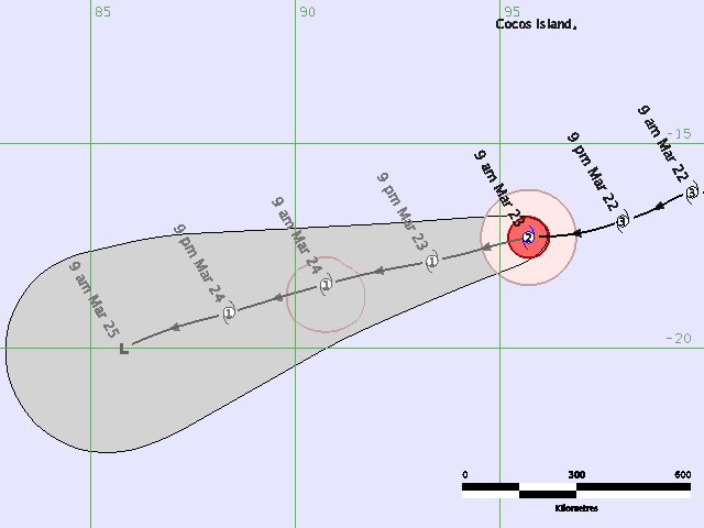
Name: Severe Tropical Cyclone Ilsa
Identifier: 18U
Data At: 0000 UTC
Latitude: 16.2S
Longitude: 99.7E
Location Accuracy: within 20 nm [37 km]
Movement Towards: west [270 deg]
Speed of Movement: 7 knots [12 km/h]
Maximum 10-Minute Wind: 75 knots [140 km/h]
Maximum 3-Second Wind Gust: 105 knots [195 km/h]
Central Pressure: 970 hPa
Radius of 34-knot winds NE quadrant: 60 nm [110 km]
Radius of 34-knot winds SE quadrant: 70 nm [130 km]
Radius of 34-knot winds SW quadrant: 80 nm [150 km]
Radius of 34-knot winds NW quadrant: 60 nm [110 km]
Radius of 48-knot winds NE quadrant: 35 nm [65 km]
Radius of 48-knot winds SE quadrant: 35 nm [65 km]
Radius of 48-knot winds SW quadrant: 35 nm [65 km]
Radius of 48-knot winds NW quadrant: 35 nm [65 km]
Radius of 64-knot winds: 25 nm [46 km]
Radius of Maximum Winds: 15 nm [28 km]
Dvorak Intensity Code: T4.0/4.5/W1.0/24HRS
Pressure of outermost isobar: 1006 hPa
Radius of outermost closed isobar: 90 nm [165 km]
Storm Depth: Deep
FORECAST DATA
Date/Time : Location : Loc. Accuracy: Max Wind : Central Pressure
[UTC] : degrees : nm [km]: knots[km/h]: hPa
+12: 22/1200: 16.4S 98.0E: 050 [095]: 065 [120]: 979
+24: 23/0000: 16.6S 95.6E: 080 [150]: 055 [100]: 987
+36: 23/1200: 16.8S 92.8E: 110 [210]: 050 [095]: 991
+48: 24/0000: 17.4S 90.2E: 145 [270]: 045 [085]: 994
+60: 24/1200: 18.1S 88.1E: 190 [355]: 040 [075]: 996
+72: 25/0000: 19.0S 85.8E: 240 [445]: 035 [065]: 999
REMARKS:
Ilsa persists as a severe TC with microwave imagery maintaintaining a well
defined inner core of deep convection and IR imagery, while not showing an eye,
shows very cold cloud tops persisting. Continuing good upper level outflow
especially poleward, and light shear is assisting the intensity of the system.
Dvorak: DT=5.0 based on Embedded Centre pattern [Black surround], but MET=4.5
and pattern T=4.0 which is FT. CI held higher at 4.5 and max wind chosen at 75
knots [4.5+].
However, most recent imagery is indicating some weakening in the cloud
signature. TPW shows the system is becoming more isolated from deep tropical
moisture and system is tracking towards cooler SSTs.
Gradual weakening is expected as Ilsa tracks over increasingly unfavourable
waters, and as the upper level flow becomes less favourable.
A general west to west southwest is expected in the next 72 hours under the
influence of a persisting mid-level ridge to the south.
Copyright Commonwealth of Australia
==
The next bulletin for this system will be issued by: 22/0700 UTC by Perth TCWC.
SIO: ILSA - ex-Tropical Cyclone (22S)
Moderator: S2k Moderators
-
HURAKAN

- Professional-Met

- Posts: 46084
- Age: 39
- Joined: Thu May 20, 2004 4:34 pm
- Location: Key West, FL
- Contact:
Re: SIO: ILSA - Severe Tropical Cyclone (22S)

TROPICAL CYCLONE TECHNICAL BULLETIN: AUSTRALIA - WESTERN REGION
Issued by PERTH TROPICAL CYCLONE WARNING CENTRE
at: 0045 UTC 23/03/2009
Name: Tropical Cyclone Ilsa
Identifier: 18U
Data At: 0000 UTC
Latitude: 17.3S
Longitude: 95.7E
Location Accuracy: within 30 nm [55 km]
Movement Towards: west southwest [258 deg]
Speed of Movement: 10 knots [18 km/h]
Maximum 10-Minute Wind: 50 knots [95 km/h]
Maximum 3-Second Wind Gust: 70 knots [130 km/h]
Central Pressure: 992 hPa
Radius of 34-knot winds NE quadrant: 70 nm [130 km]
Radius of 34-knot winds SE quadrant: 70 nm [130 km]
Radius of 34-knot winds SW quadrant: 70 nm [130 km]
Radius of 34-knot winds NW quadrant: 70 nm [130 km]
Radius of 48-knot winds NE quadrant: 30 nm [55 km]
Radius of 48-knot winds SE quadrant: 30 nm [55 km]
Radius of 48-knot winds SW quadrant: 30 nm [55 km]
Radius of 48-knot winds NW quadrant: 30 nm [55 km]
Radius of 64-knot winds:
Radius of Maximum Winds: 15 nm [28 km]
Dvorak Intensity Code: T3.0/3.5/W1.0/24HRS
Pressure of outermost isobar: 1008 hPa
Radius of outermost closed isobar: 90 nm [165 km]
Storm Depth: Deep
FORECAST DATA
Date/Time : Location : Loc. Accuracy: Max Wind : Central Pressure
[UTC] : degrees : nm [km]: knots[km/h]: hPa
+12: 23/1200: 17.9S 93.3E: 060 [110]: 045 [085]: 996
+24: 24/0000: 18.4S 90.8E: 090 [165]: 040 [075]: 998
+36: 24/1200: 19.1S 88.4E: 120 [225]: 040 [075]: 998
+48: 25/0000: 20.0S 85.8E: 155 [285]: 030 [055]: 1005
+60: 25/1200: 21.5S 83.4E: 200 [375]: 030 [055]: 1004
+72: 26/0000: 22.8S 81.0E: 250 [465]: 030 [055]: 1003
REMARKS:
Ilsa has weakened overnight due to movement over cooler SSTs and a slight
increase in SE'ly shear.
Recent microwave imagery shows the LLCC almost exposed from the deep convection
which is mainly to the north of the LLCC.
Dvorak at 1800 UTC was reanalysed with FT 3.5 based on MET/PAT with CI 4.0. DT
of 3.0 over the last 3 hours based on shear pattern with centre <0.5 degree from
DG. 24 hr trend is W with FT 3.0 and CI 3.5.
Weakening should continue as the system tracks over increasingly unfavourable
SSTs, and as the upper level flow becomes less favourable.
A general west southwest track is expected in the next 72 hours under the
influence of a persisting mid-level ridge to the south.
Copyright Commonwealth of Australia
==
The next bulletin for this system will be issued by: 23/0700 UTC by Perth TCWC.
0 likes
AXAU01 APRF 230644
IDW27600
TROPICAL CYCLONE TECHNICAL BULLETIN: AUSTRALIA - WESTERN REGION
Issued by PERTH TROPICAL CYCLONE WARNING CENTRE
at: 0643 UTC 23/03/2009
Name: Tropical Cyclone Ilsa
Identifier: 18U
Data At: 0600 UTC
Latitude: 17.5S
Longitude: 94.4E
Location Accuracy: within 20 nm [37 km]
Movement Towards: west [260 deg]
Speed of Movement: 12 knots [22 km/h]
Maximum 10-Minute Wind: 50 knots [95 km/h]
Maximum 3-Second Wind Gust: 70 knots [130 km/h]
Central Pressure: 993 hPa
Radius of 34-knot winds NE quadrant: 70 nm [130 km]
Radius of 34-knot winds SE quadrant: 70 nm [130 km]
Radius of 34-knot winds SW quadrant: 70 nm [130 km]
Radius of 34-knot winds NW quadrant: 70 nm [130 km]
Radius of 48-knot winds NE quadrant: 30 nm [55 km]
Radius of 48-knot winds SE quadrant: 30 nm [55 km]
Radius of 48-knot winds SW quadrant: 30 nm [55 km]
Radius of 48-knot winds NW quadrant: 30 nm [55 km]
Radius of 64-knot winds:
Radius of Maximum Winds: 15 nm [28 km]
Dvorak Intensity Code: T3.0/3.0/W1.0/24HRS
Pressure of outermost isobar: 1008 hPa
Radius of outermost closed isobar: 50 nm [95 km]
Storm Depth: Deep
FORECAST DATA
Date/Time : Location : Loc. Accuracy: Max Wind : Central Pressure
[UTC] : degrees : nm [km]: knots[km/h]: hPa
+12: 23/1800: 18.2S 91.9E: 050 [095]: 040 [075]: 999
+24: 24/0600: 18.9S 89.5E: 080 [150]: 035 [065]: 1001
+36: 24/1800: 19.9S 87.2E: 110 [210]: 035 [065]: 1001
+48: 25/0600: 21.0S 84.6E: 145 [270]: 030 [055]: 1004
+60: 25/1800: 22.5S 82.4E: 190 [355]: 025 [045]: 1008
+72: 26/0600: 24.7S 81.2E: 240 [445]: 020 [035]: 1009
REMARKS:
Ilsa is steadily weakening due to cooler SSTs and a slight increase in shear.
Very little deep convection remains and the tightly wound LLCC is clearly
evident on VIS imagery. It is unlikely that a significant overcast will reform
and the system should continue to weaken, although a translation speed of 10-15
knots and the pressure gradient associated with the ridge to the south will help
to maintain gales in southern quadrants.
Dvorak is based on shear pattern and DT is clearly 3.0, MET/PAT agree and FT is
3.0. Using a 6 hour weakening rule CI is dropped to 3.0 but discretion is used
to hold intensity to 50 knots for this issue.
A general west southwest track is expected during the next 48 hours under the
continuing influence of a mid-level ridge to the south.
Copyright Commonwealth of Australia
==
The next bulletin for this system will be issued by: 23/1300 UTC by Perth TCWC.
0 likes


-
HURAKAN
- Professional-Met
- Posts: 46084
- Age: 39
- Joined: Thu May 20, 2004 4:34 pm
- Location: Key West, FL
- Contact:
TROPICAL CYCLONE TECHNICAL BULLETIN: AUSTRALIA - WESTERN REGION
Issued by PERTH TROPICAL CYCLONE WARNING CENTRE
at: 1242 UTC 23/03/2009
Name: Tropical Cyclone Ilsa
Identifier: 18U
Data At: 1200 UTC
Latitude: 18.0S
Longitude: 93.3E
Location Accuracy: within 20 nm [37 km]
Movement Towards: west southwest [242 deg]
Speed of Movement: 11 knots [20 km/h]
Maximum 10-Minute Wind: 45 knots [85 km/h]
Maximum 3-Second Wind Gust: 65 knots [120 km/h]
Central Pressure: 996 hPa
Radius of 34-knot winds NE quadrant: 70 nm [130 km]
Radius of 34-knot winds SE quadrant: 70 nm [130 km]
Radius of 34-knot winds SW quadrant: 70 nm [130 km]
Radius of 34-knot winds NW quadrant: 70 nm [130 km]
Radius of 48-knot winds NE quadrant:
Radius of 48-knot winds SE quadrant:
Radius of 48-knot winds SW quadrant:
Radius of 48-knot winds NW quadrant:
Radius of 64-knot winds:
Radius of Maximum Winds: 15 nm [28 km]
Dvorak Intensity Code: T2.5/3.0/W1.5/24HRS
Pressure of outermost isobar: 1008 hPa
Radius of outermost closed isobar: 90 nm [165 km]
Storm Depth: Deep
FORECAST DATA
Date/Time : Location : Loc. Accuracy: Max Wind : Central Pressure
[UTC] : degrees : nm [km]: knots[km/h]: hPa
+12: 24/0000: 18.8S 90.8E: 050 [095]: 040 [075]: 998
+24: 24/1200: 19.7S 88.2E: 080 [150]: 035 [065]: 1002
+36: 25/0000: 20.8S 85.7E: 110 [210]: 030 [055]: 1004
+48: 25/1200: 22.4S 82.9E: 145 [270]: 030 [055]: 1004
+60: 26/0000: 24.2S 81.2E: 190 [355]: 025 [045]: 1006
+72: 26/1200: 26.2S 80.8E: 240 [445]: 025 [045]: 1004
REMARKS:
Ilsa is steadily weakening due to cooler SSTs and increasing SE shear. The
tightly wound low level circulation centre is now separated from deep
convection. It is unlikely that a significant overcast will reform and the
system should continue to weaken, although a translation speed of 10-15 knots
and the pressure gradient associated with the ridge to the south will help to
maintain gales in southern quadrants.
Dvorak analysis: DT=2.5 or 3.0 based on shear pattern [separation of -0.5
degree]. MET/PAT=2.5 based on strong weakening in 24 hours. FT chosed at 2.5
[3.0 is also valid] and CI=3.0.
A general west southwest track is expected during the next 48 hours under the
continuing influence of a mid-level ridge to the south.
Copyright Commonwealth of Australia
==
The next bulletin for this system will be issued by: 23/1900 UTC by Perth TCWC.
0 likes

-
HURAKAN
- Professional-Met
- Posts: 46084
- Age: 39
- Joined: Thu May 20, 2004 4:34 pm
- Location: Key West, FL
- Contact:
TROPICAL CYCLONE TECHNICAL BULLETIN: AUSTRALIA - WESTERN REGION
Issued by PERTH TROPICAL CYCLONE WARNING CENTRE
at: 0017 UTC 24/03/2009
Name: Ex-Tropical Cyclone Ilsa
Identifier: 18U
Data At: 0000 UTC
Latitude: 19.3S
Longitude: 90.1E
Location Accuracy: within 25 nm [46 km]
Movement Towards: west southwest [247 deg]
Speed of Movement: 14 knots [27 km/h]
Maximum 10-Minute Wind: 30 knots [55 km/h]
Maximum 3-Second Wind Gust: 45 knots [85 km/h]
Central Pressure: 1005 hPa
Radius of 34-knot winds NE quadrant:
Radius of 34-knot winds SE quadrant:
Radius of 34-knot winds SW quadrant:
Radius of 34-knot winds NW quadrant:
Radius of 48-knot winds NE quadrant:
Radius of 48-knot winds SE quadrant:
Radius of 48-knot winds SW quadrant:
Radius of 48-knot winds NW quadrant:
Radius of 64-knot winds:
Radius of Maximum Winds: N/A
Dvorak Intensity Code: T2.0/2.5/W1.0/24HRS
Pressure of outermost isobar: 1008 hPa
Radius of outermost closed isobar: 70 nm [130 km]
Storm Depth: Shallow
FORECAST DATA
Date/Time : Location : Loc. Accuracy: Max Wind : Central Pressure
[UTC] : degrees : nm [km]: knots[km/h]: hPa
+12: 24/1200: 20.3S 87.4E: 055 [100]: 025 [045]: 1008
+24: 25/0000: 21.4S 84.7E: 085 [155]: 020 [035]: 1010
+36: 25/1200: 22.7S 82.0E: 120 [220]: 020 [035]: 1010
+48: 26/0000: 24.3S 79.9E: 150 [280]: 015 [030]: 1012
+60: 26/1200: : : :
+72: 27/0000: : : :
REMARKS:
Ilsa has weakened below TC intensity under the influence of moderate shear over
cool SSTs. No deep convection remains. Near gale force winds may persist for a
period in the southern quadrant due to translation speed and the pressure
gradient associated with the ridge to the south.
Copyright Commonwealth of Australia
==
The next bulletin for this system will be issued by: 24/0700 UTC by Perth TCWC.
0 likes


-
Grifforzer
- Category 1

- Posts: 418
- Joined: Thu Feb 26, 2009 11:27 pm
Re:
Chacor wrote:By the way, MF no longer renames cyclones, I believe.
Mauritius cyclone page still states they do.
CLASSIFICATION OF TROPICAL CYCLONES IN THE SOUTH-WEST INDIAN OCEAN
"Whenever a cyclone moves from the Australian region of responsibility to that of Mauritius, it is given a hyphenated name comprising the names from both regions for a period of about 24 hours. Thereafter it is known by the South West Indian Ocean name. "
unless they forgot to update this information
0 likes
-
HURAKAN
- Professional-Met
- Posts: 46084
- Age: 39
- Joined: Thu May 20, 2004 4:34 pm
- Location: Key West, FL
- Contact:
Re:
Chacor wrote:I can't remember, maybe it's the Aussies who no longer do it. I know that one way or the other there's no longer any renaming.
"If a named cyclone moves into the Australian region from another country's zone of responsibility, the name assigned by that other country will be retained."
Link: http://www.bom.gov.au/weather/cyclone/a ... ames.shtml
0 likes

Who is online
Users browsing this forum: No registered users and 38 guests