TROPICAL CYCLONE TECHNICAL BULLETIN: AUSTRALIA - NORTHERN REGION
Issued by DARWIN TROPICAL CYCLONE WARNING CENTRE
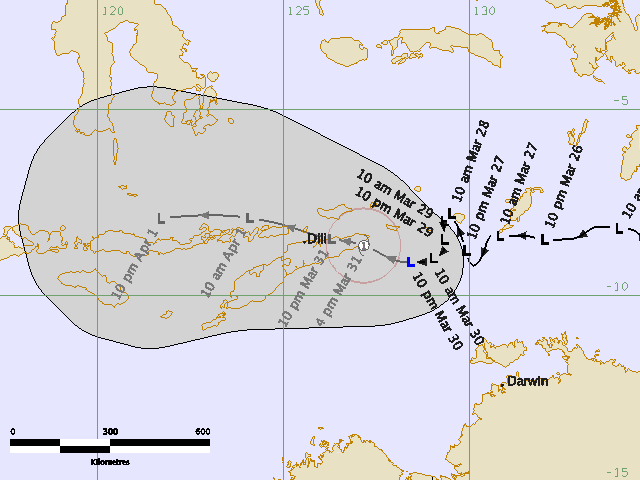
at: 0735 UTC 29/03/2009
Name: Tropical Low
Identifier: 21U
Data At: 0600 UTC
Latitude: 8.1S
Longitude: 129.3E
Location Accuracy: within 50 nm [95 km]
Movement Towards: south [180 deg]
Speed of Movement: 1 knot [1 km/h]
Maximum 10-Minute Wind: 25 knots [45 km/h]
Maximum 3-Second Wind Gust: 45 knots [85 km/h]
Central Pressure: 1002 hPa
Radius of 34-knot winds NE quadrant:
Radius of 34-knot winds SE quadrant:
Radius of 34-knot winds SW quadrant:
Radius of 34-knot winds NW quadrant:
Radius of 48-knot winds NE quadrant:
Radius of 48-knot winds SE quadrant:
Radius of 48-knot winds SW quadrant:
Radius of 48-knot winds NW quadrant:
Radius of 64-knot winds:
Radius of Maximum Winds:
Dvorak Intensity Code: T2.0/2.0/D1.0/24HRS
Pressure of outermost isobar: 1006 hPa
Radius of outermost closed isobar: 90 nm [165 km]
Storm Depth: Medium
FORECAST DATA
Date/Time : Location : Loc. Accuracy: Max Wind : Central Pressure
[UTC] : degrees : nm [km]: knots[km/h]: hPa
+12: 29/1800: 8.3S 128.8E: 080 [150]: 035 [065]: 998
+24: 30/0600: 8.5S 128.0E: 110 [205]: 040 [075]: 995
+36: 30/1800: 8.5S 127.3E: 140 [265]: 040 [075]: 995
+48: 31/0600: 8.5S 125.7E: 175 [325]: 030 [055]: 1001
+60: 31/1800: 8.3S 124.1E: 220 [410]: 030 [055]: 1001
+72: 01/0600: 7.6S 121.8E: 270 [500]: 030 [055]: 1002
REMARKS:
Tropical low has exhibited good convective development overnight. Low level
circulation centre is obscured beneath cirrus, so position, based on 0530UTC
MTSAT vis imagery, is poor, but is supported by 0149UTC TRMM 85 GHz imagery.
Dvorak FT of 2.0 based on MET of 2.5 reduced to 2.0 in PT. DT based on spiral
wrap of 0.25 [Vis] or 0.35 [IR], so on average in DT 1.5 +/- 0.5 range.
Environmental vertical shear has decreased significantly recently, allowing
development which is forecast to continue at standard rate in short term.
Longer term intensity forecast is uncertain as it will depend sensitively on
track and resulting effect of islands, in particular the mountains of Timor.
Dry air from the south may also become an inhibiting factor in the longer term.
Low has become slow moving in last 12 hours. Latest model consensus [06Z GFS,
00Z TXLAPS, JMA, UK and 12Z EC] has the system slow moving then moving westward
over Timor and weakening after interaction with the island. Westward movement
is consistent with the current mid-level ridge to the south. Model forecasts
suggest that the 500hPa ridge will weaken in the next few days as a trough
approaches Australia from the Indian Ocean, but by that stage the weakened
system will be more influenced by the low level easterly flow which will push it
more quickly west.
Intensity forecast based on expected track has weakening below cyclone intensity
in 48 hours as the system interacts with East Timor, but if the system is slower
moving or takes a more southwesterly track than forecast, there is potential for
the system to retain cyclone intensity for longer.
Copyright Commonwealth of Australia
==
The next bulletin for this system will be issued by: 29/1330 UTC by Darwin TCWC.