Severe Weather Potential - Thursday 9th - Sunday 12th April
Moderator: S2k Moderators
Forum rules

The posts in this forum are NOT official forecast and should not be used as such. They are just the opinion of the poster and may or may not be backed by sound meteorological data. They are NOT endorsed by any professional institution or STORM2K.


-
CrazyC83
- Professional-Met

- Posts: 34315
- Joined: Tue Mar 07, 2006 11:57 pm
- Location: Deep South, for the first time!
Re:
RL3AO wrote:20z is still two hours away. They occasionally issue special convective outlooks don't they? This may be time for one.
Occasionally they do, but usually for sudden, unexpected developments. They were probably waiting for additional initiation at 1630Z. But I agree a HIGH risk should be seriously considered.
0 likes
-
srainhoutx

- S2K Supporter

- Posts: 6919
- Age: 68
- Joined: Sun Jan 14, 2007 11:34 am
- Location: Haywood County, NC
- Contact:
Re: Severe Weather Potential - Thursday 9th - Sunday 12th April
Strong hook echo near Lewisville, TN
0 likes

Re: Severe Weather Potential - Thursday 9th - Sunday 12th April
The tornado outbreak is rapidly unfolding. I am afraid lives will be lost today. Numerous tornado warnings being issued. Everyone be safe across the Deep South.
0 likes
-
CrazyC83
- Professional-Met
- Posts: 34315
- Joined: Tue Mar 07, 2006 11:57 pm
- Location: Deep South, for the first time!
MESOSCALE DISCUSSION 0430
NWS STORM PREDICTION CENTER NORMAN OK
1258 PM CDT FRI APR 10 2009
AREAS AFFECTED...NERN MS...NRN AL THROUGH MIDDLE TN
CONCERNING...TORNADO WATCH 132...
VALID 101758Z - 101930Z
THE SEVERE WEATHER THREAT FOR TORNADO WATCH 132 CONTINUES.
THREAT FOR STRONG/DAMAGING TORNADOES WILL LIKELY PERSIST NEXT FEW
HOURS WITH STORMS MOVING THROUGH MIDDLE TN INTO NRN AL. LARGE HAIL
AND DAMAGING WIND MAY ALSO ACCOMPANY SOME OF THE STRONGER STORMS.
COUPLE OF LINES OF MOSTLY DISCRETE SUPERCELLS CONTINUE FROM MIDDLE
TN SWWD THROUGH EXTREME NERN MS INTO NW AL. THE ATMOSPHERE REMAINS
MODERATELY UNSTABLE WITH MINIMAL CONVECTIVE INHIBITION ALLOWING
STORMS TO CONTINUE DEVELOPING ALONG CLOUD STREETS IN WARM SECTOR
AHEAD OF THE EWD ADVANCING COLD FRONT. BULK SHEAR OF 50+ KT AND
LARGE HODOGRAPHS WITH 0-1 KM STORM RELATIVE HELICITY FROM 200-300
M2/S2 ASSOCIATED WITH THE EWD ADVANCING SHORTWAVE TROUGH WILL
CONTINUE TO PROMOTE SUPERCELLS WITH LOW LEVEL MESOCYCLONES. GIVEN
THE PROPENSITY TO MAINTAIN DISCRETE STORMS WITHIN THE FAVORABLY
SHEARED AND MODERATELY UNSTABLE ENVIRONMENT...SOME SUPERCELLS WILL
REMAIN CAPABLE OF PRODUCING STRONG TORNADOES NEXT FEW HOURS.
..DIAL.. 04/10/2009
ATTN...WFO...MRX...OHX...BMX...HUN...MEG...
LAT...LON 35588530 34408617 33568771 34038864 35298742 36538647
36358553 35588530
0 likes
-
CrazyC83
- Professional-Met
- Posts: 34315
- Joined: Tue Mar 07, 2006 11:57 pm
- Location: Deep South, for the first time!
Re: Severe Weather Potential - Thursday 9th - Sunday 12th April
TORNADO WARNING
KYC047-107-177-219-101845-
/O.NEW.KPAH.TO.W.0035.090410T1755Z-090410T1845Z/
BULLETIN - EAS ACTIVATION REQUESTED
TORNADO WARNING
NATIONAL WEATHER SERVICE PADUCAH KY
1255 PM CDT FRI APR 10 2009
THE NATIONAL WEATHER SERVICE IN PADUCAH HAS ISSUED A
* TORNADO WARNING FOR...
SOUTHEASTERN HOPKINS COUNTY IN NORTHWEST KENTUCKY...
NORTHEASTERN CHRISTIAN COUNTY IN SOUTH CENTRAL KENTUCKY...
MUHLENBERG COUNTY IN SOUTH CENTRAL KENTUCKY...
NORTHERN TODD COUNTY IN SOUTH CENTRAL KENTUCKY...
* UNTIL 145 PM CDT
* AT 1254 PM CDT...TRAINED WEATHER SPOTTERS REPORTED A TORNADO NEAR
CROFTON IN CHRISTIAN COUNTY...OR 14 MILES NORTH OF HOPKINSVILLE...
MOVING NORTHEAST AT 30 MPH.
* THE TORNADO WILL BE NEAR...
GREENVILLE BY 125 PM CDT...
6 MILES SOUTHEAST OF POWDERLY BY 130 PM CDT...
7 MILES NORTHWEST OF DUNMOR BY 135 PM CDT...
9 MILES SOUTHEAST OF CENTRAL CITY BY 140 PM CDT...
PRECAUTIONARY/PREPAREDNESS ACTIONS...
THIS IS AN EXTREMELY DANGEROUS AND LIFE THREATENING SITUATION. THIS
STORM IS CAPABLE OF PRODUCING STRONG TO VIOLENT TORNADOES. IF YOU ARE
IN THE PATH OF THIS TORNADO...TAKE COVER IMMEDIATELY!
A TORNADO WATCH REMAINS IN EFFECT UNTIL 400 PM CDT FRIDAY AFTERNOON
FOR SOUTHEASTERN ILLINOIS AND SOUTHWEST INDIANA AND WESTERN KENTUCKY.
&&
LAT...LON 3709 8690 3707 8694 3706 8706 3695 8706
3695 8746 3719 8737 3735 8712 3734 8711
3738 8707 3737 8704 3732 8699 3727 8698
3722 8690 3714 8693 3713 8689
TIME...MOT...LOC 1754Z 243DEG 25KT 3704 8739
$$
0 likes
-
srainhoutx
- S2K Supporter
- Posts: 6919
- Age: 68
- Joined: Sun Jan 14, 2007 11:34 am
- Location: Haywood County, NC
- Contact:
Re: Severe Weather Potential - Thursday 9th - Sunday 12th April
I think when we saw the VIS SAT shot this morning, we knew it was not going to be a good day.
0 likes
-
CrazyC83
- Professional-Met
- Posts: 34315
- Joined: Tue Mar 07, 2006 11:57 pm
- Location: Deep South, for the first time!
Re: Re:
Bunkertor wrote:RL3AO wrote:20z is still two hours away. They occasionally issue special convective outlooks don't they? This may be time for one.
Weird. The 1630 outlook was history within 20 minutes.
I think if the outlook was issued at 1700Z, a high risk might have been issued. I could understand holding back then. But I don't see this letting up anytime soon.
I'm most concerned about the many rural churches out there - this could be a repeat of the 1994 Palm Sunday outbreak.
0 likes
-
srainhoutx
- S2K Supporter
- Posts: 6919
- Age: 68
- Joined: Sun Jan 14, 2007 11:34 am
- Location: Haywood County, NC
- Contact:
Re: Severe Weather Potential - Thursday 9th - Sunday 12th April
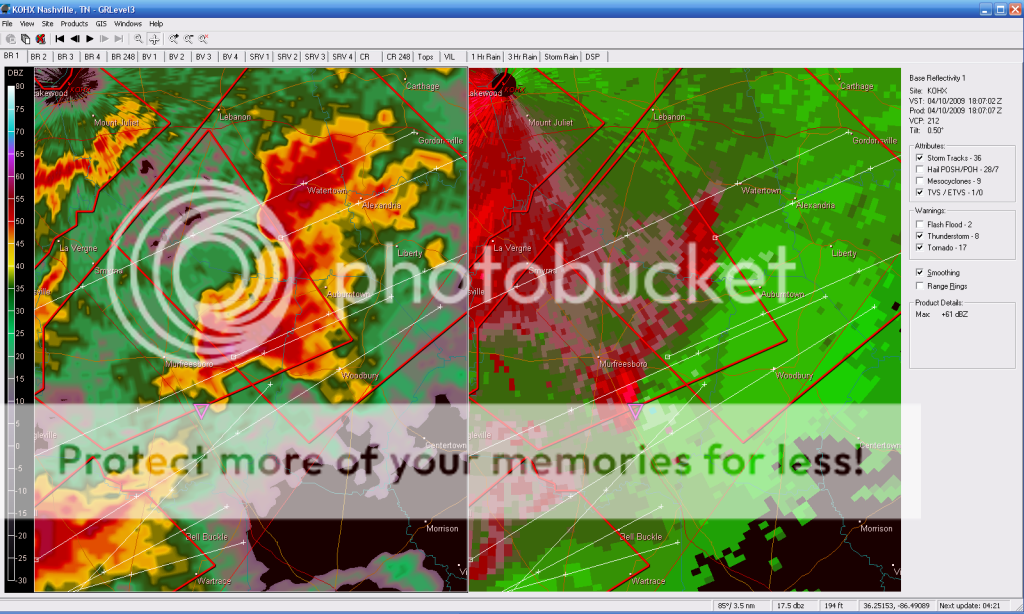
Anybody have a shot on GR for the cuplet south of Murfreesboro now?
0 likes
Re: Severe Weather Potential - Thursday 9th - Sunday 12th April
srainhoutx wrote:Anybody have a shot on GR for the cuplet south of Murfreesboro now?
0 likes
-
Dave

- Retired Staff

- Posts: 13442
- Age: 75
- Joined: Tue Aug 01, 2006 3:57 pm
- Location: Milan Indiana
- Contact:
Date: Apr 10 12:54:00 EDT
Type: TORNADO
City: MANNINGTON
County: CHRISTIAN
State: KY
Source: EMERGENCY MNGR
Details: CONFIRMED TORNADO BY TRAINED SPOTTER AND EM OFFICE.
------------------
Date: Apr 10 12:54:00 EDT
Type: TORNADO
City: MANNINGTON
County: CHRISTIAN
State: KY
Source: EMERGENCY MNGR
Details: *** 2 INJ *** CONFIRMED TORNADO BY TRAINED SPOTTER AND EM OFFICE...UPDATE 1158 AM..REPORTS OF INJURIES AT MANNINGTON LOOP...EMERGENCY VEHICLES RESPONDING AT THIS TIME.
Type: TORNADO
City: MANNINGTON
County: CHRISTIAN
State: KY
Source: EMERGENCY MNGR
Details: CONFIRMED TORNADO BY TRAINED SPOTTER AND EM OFFICE.
------------------
Date: Apr 10 12:54:00 EDT
Type: TORNADO
City: MANNINGTON
County: CHRISTIAN
State: KY
Source: EMERGENCY MNGR
Details: *** 2 INJ *** CONFIRMED TORNADO BY TRAINED SPOTTER AND EM OFFICE...UPDATE 1158 AM..REPORTS OF INJURIES AT MANNINGTON LOOP...EMERGENCY VEHICLES RESPONDING AT THIS TIME.
0 likes
-
Brent
- S2K Supporter
- Posts: 38755
- Age: 37
- Joined: Sun May 16, 2004 10:30 pm
- Location: Tulsa Oklahoma
- Contact:
Re: Severe Weather Potential - Thursday 9th - Sunday 12th April
Good grief at the radar in Tennessee. I've never seen so many tornadic supercells in a small area before. 
My computer decided to pick today of all day to misbehave.
My computer decided to pick today of all day to misbehave.
0 likes
-
Dave
- Retired Staff
- Posts: 13442
- Age: 75
- Joined: Tue Aug 01, 2006 3:57 pm
- Location: Milan Indiana
- Contact:
BULLETIN - EAS ACTIVATION REQUESTED
TORNADO WARNING
NATIONAL WEATHER SERVICE NASHVILLE TN
1257 PM CDT FRI APR 10 2009
THE NATIONAL WEATHER SERVICE IN NASHVILLE HAS ISSUED A
* TORNADO WARNING FOR...
CANNON COUNTY IN MIDDLE TENNESSEE...
THIS INCLUDES THE CITY OF WOODBURY...
DEKALB COUNTY IN MIDDLE TENNESSEE...
THIS INCLUDES THE CITY OF SMITHVILLE...
NORTHEASTERN RUTHERFORD COUNTY IN MIDDLE TENNESSEE...
SOUTHERN SMITH COUNTY IN MIDDLE TENNESSEE...
SOUTH CENTRAL TROUSDALE COUNTY IN MIDDLE TENNESSEE...
SOUTHEASTERN WILSON COUNTY IN MIDDLE TENNESSEE...
* UNTIL 145 PM CDT
* AT 1257 PM CDT...NATIONAL WEATHER SERVICE DOPPLER RADAR INDICATED A
SEVERE THUNDERSTORM CAPABLE OF PRODUCING A TORNADO NEAR
WALTERHILL...OR 7 MILES NORTHEAST OF MURFREESBORO...MOVING
NORTHEAST AT 45 MPH.
* THE TORNADO WILL BE NEAR...
WATERTOWN BY 115 PM CDT...
GORDONSVILLE BY 130 PM CDT...
0 likes
-
srainhoutx
- S2K Supporter
- Posts: 6919
- Age: 68
- Joined: Sun Jan 14, 2007 11:34 am
- Location: Haywood County, NC
- Contact:
Re: Severe Weather Potential - Thursday 9th - Sunday 12th April
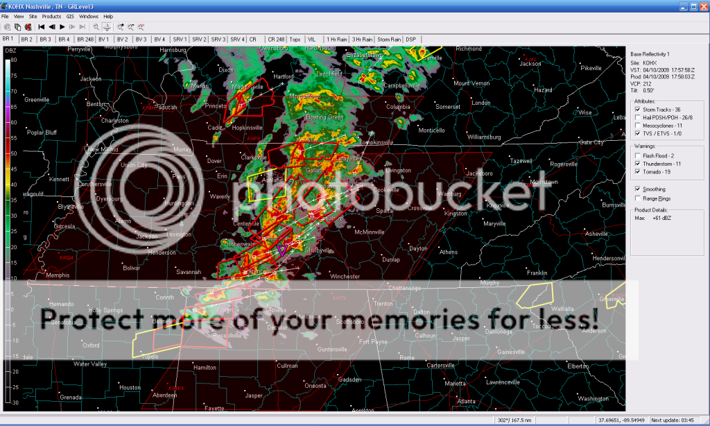
Shelbyville/Bedford, TN need to watch out. Very strong cuplet.
0 likes
Return to “USA & Caribbean Weather”
Who is online
Users browsing this forum: No registered users and 106 guests