BULLETIN - EAS ACTIVATION REQUESTED
TORNADO WARNING
NATIONAL WEATHER SERVICE DODGE CITY KS
334 PM CDT SAT APR 18 2009
THE NATIONAL WEATHER SERVICE IN DODGE CITY HAS ISSUED A
* TORNADO WARNING FOR...
NORTHEASTERN HODGEMAN COUNTY IN SOUTHWEST KANSAS.
SOUTHEASTERN NESS COUNTY IN WEST CENTRAL KANSAS.
* UNTIL 415 PM CDT
* AT 331 PM CDT...NATIONAL WEATHER SERVICE DOPPLER RADAR INDICATED A
SEVERE THUNDERSTORM CAPABLE OF PRODUCING A TORNADO 2 MILES WEST OF
GRAY...MOVING NORTH AT 15 MPH.
* LOCATIONS IMPACTED INCLUDE...
GRAY...
RURAL RESIDENCES OF NORTHEASTERN HODGEMAN AND SOUTHEASTERN NESS
COUNTIES.
S. Plains Severe April 17th to 19th?
Moderator: S2k Moderators
Forum rules

The posts in this forum are NOT official forecast and should not be used as such. They are just the opinion of the poster and may or may not be backed by sound meteorological data. They are NOT endorsed by any professional institution or STORM2K.
-
Dave

- Retired Staff

- Posts: 13442
- Age: 75
- Joined: Tue Aug 01, 2006 3:57 pm
- Location: Milan Indiana
- Contact:
BULLETIN - EAS ACTIVATION REQUESTED
TORNADO WARNING
NATIONAL WEATHER SERVICE HOUSTON/GALVESTON TX
346 PM CDT SAT APR 18 2009
THE NATIONAL WEATHER SERVICE IN LEAGUE CITY HAS ISSUED A
* TORNADO WARNING FOR...
EASTERN BRAZORIA COUNTY IN SOUTHEAST TEXAS...
SOUTHERN GALVESTON COUNTY IN SOUTHEAST TEXAS...
* UNTIL 415 PM CDT
* AT 345 PM CDT...NATIONAL WEATHER SERVICE DOPPLER RADAR INDICATED A
SEVERE THUNDERSTORM CAPABLE OF PRODUCING A TORNADO THIS TORNADO
WAS LOCATED 10 MILES NORTHWEST OF JAMAICA BEACH... MOVING SOUTHEAST
AT 15 MPH.
* LOCATIONS IN THE TORNADO WARNING INCLUDE BUT ARE NOT LIMITED TO
GALVESTON STATE PARK.
0 likes
-
Dave
- Retired Staff
- Posts: 13442
- Age: 75
- Joined: Tue Aug 01, 2006 3:57 pm
- Location: Milan Indiana
- Contact:
GALVESTON TX-
354 PM CDT SAT APR 18 2009
...A TORNADO WARNING REMAINS IN EFFECT UNTIL 415 PM CDT FOR GALVESTON
COUNTY...
AT 351 PM CDT...NATIONAL WEATHER SERVICE DOPPLER RADAR INDICATED A
TORNADO. THIS TORNADO WAS LOCATED 9 MILES WEST OF JAMAICA BEACH...OR
8 MILES SOUTHWEST OF HITCHCOCK...AND MOVING SOUTHEAST AT 15 MPH. RAPID
SPIN UPS ARE POSSIBLE IN OTHER PARTS OF THE WARNED AREA AS WELL.
* LOCATIONS IN THE THE TORNADO WARNING INCLUDE BUT ARE NOT LIMITED TO
GALVESTON STATE PARK
0 likes
-
Dave
- Retired Staff
- Posts: 13442
- Age: 75
- Joined: Tue Aug 01, 2006 3:57 pm
- Location: Milan Indiana
- Contact:
BULLETIN - EAS ACTIVATION REQUESTED
TORNADO WARNING
NATIONAL WEATHER SERVICE HOUSTON/GALVESTON TX
404 PM CDT SAT APR 18 2009
THE NATIONAL WEATHER SERVICE IN LEAGUE CITY HAS ISSUED A
* TORNADO WARNING FOR...
CENTRAL GALVESTON COUNTY IN SOUTHEAST TEXAS...
* UNTIL 445 PM CDT
* AT 401 PM CDT...NATIONAL WEATHER SERVICE DOPPLER RADAR INDICATED A
SEVERE THUNDERSTORM CAPABLE OF PRODUCING A TORNADO THIS TORNADO
WAS LOCATED NEAR TIKI ISLAND... MOVING SOUTHEAST AT 35 MPH.
* LOCATIONS IN THE TORNADO WARNING INCLUDE BUT ARE NOT LIMITED TO
SCHLITTERBAHN...PELICAN ISLAND...MOODY GARDENS...GALVESTON...TEXAS
CITY AND BAYOU VISTA.
0 likes
-
Dave
- Retired Staff
- Posts: 13442
- Age: 75
- Joined: Tue Aug 01, 2006 3:57 pm
- Location: Milan Indiana
- Contact:
BULLETIN - EAS ACTIVATION REQUESTED
TORNADO WARNING
NATIONAL WEATHER SERVICE NORMAN OK
445 PM CDT SAT APR 18 2009
THE NATIONAL WEATHER SERVICE IN NORMAN HAS ISSUED A
* TORNADO WARNING FOR...
NORTHWESTERN ALFALFA COUNTY IN NORTHWEST OKLAHOMA...
NORTHEASTERN WOODS COUNTY IN NORTHWEST OKLAHOMA...
* UNTIL 530 PM CDT
* AT 446 PM CDT...NATIONAL WEATHER SERVICE DOPPLER RADAR INDICATED A
SEVERE THUNDERSTORM CAPABLE OF PRODUCING A TORNADO 3 MILES SOUTH OF
ALVA...MOVING NORTHEAST AT 25 MPH.
* LOCATIONS IN THE WARNING INCLUDE ALVA...AMORITA...BURLINGTON...
BYRON...CAPRON...DRIFTWOOD AND INGERSOLL.
IN ADDITION TO A TORNADO THREAT... THIS STORM LIKELY CONTAINS
DAMAGING HAIL TO THE SIZE OF BASEBALLS OR LARGER.
0 likes
-
brunota2003

- S2K Supporter

- Posts: 9476
- Age: 35
- Joined: Sat Jul 30, 2005 9:56 pm
- Location: Stanton, KY...formerly Havelock, NC
- Contact:
-
brunota2003
- S2K Supporter
- Posts: 9476
- Age: 35
- Joined: Sat Jul 30, 2005 9:56 pm
- Location: Stanton, KY...formerly Havelock, NC
- Contact:
Re: S. Plains Severe April 17th to 19th?
WWUS54 KOUN 182226
SVSOUN
SEVERE WEATHER STATEMENT
NATIONAL WEATHER SERVICE NORMAN OK
526 PM CDT SAT APR 18 2009
OKC003-151-182234-
/O.EXP.KOUN.TO.W.0014.000000T0000Z-090418T2230Z/
WOODS OK-ALFALFA OK-
526 PM CDT SAT APR 18 2009
...THE TORNADO WARNING FOR NORTHWESTERN ALFALFA AND NORTHEASTERN
WOODS COUNTIES WILL EXPIRE AT 530 PM CDT...
ALTHOUGH THIS REMAINS AN EXTREMELY DANGEROUS STORM...THE TORNADO
THREAT HAS DIMINISHED. EXTREMELY STRONG WINDS ALONG WITH GIANT HAIL
ARE STILL LIKELY...WHICH WILL RESULT IN PROPERTY DAMAGE. REMAIN IN A
STURDY BUILDING AWAY FROM WINDOWS AND THOSE IN STORM SHELTERS SHOULD
REMAIN THERE UNTIL THE STORM HAS PASSED.
This was from earlier, when this cell was Tornado Warned:
Base:

SRV:

It looks like the whole storm was nothing BUT a meso.
SVSOUN
SEVERE WEATHER STATEMENT
NATIONAL WEATHER SERVICE NORMAN OK
526 PM CDT SAT APR 18 2009
OKC003-151-182234-
/O.EXP.KOUN.TO.W.0014.000000T0000Z-090418T2230Z/
WOODS OK-ALFALFA OK-
526 PM CDT SAT APR 18 2009
...THE TORNADO WARNING FOR NORTHWESTERN ALFALFA AND NORTHEASTERN
WOODS COUNTIES WILL EXPIRE AT 530 PM CDT...
ALTHOUGH THIS REMAINS AN EXTREMELY DANGEROUS STORM...THE TORNADO
THREAT HAS DIMINISHED. EXTREMELY STRONG WINDS ALONG WITH GIANT HAIL
ARE STILL LIKELY...WHICH WILL RESULT IN PROPERTY DAMAGE. REMAIN IN A
STURDY BUILDING AWAY FROM WINDOWS AND THOSE IN STORM SHELTERS SHOULD
REMAIN THERE UNTIL THE STORM HAS PASSED.
This was from earlier, when this cell was Tornado Warned:
Base:
SRV:
It looks like the whole storm was nothing BUT a meso.
0 likes
-
Extremeweatherguy

- Category 5

- Posts: 11095
- Joined: Mon Oct 10, 2005 8:13 pm
- Location: Florida
Re: S. Plains Severe April 17th to 19th?
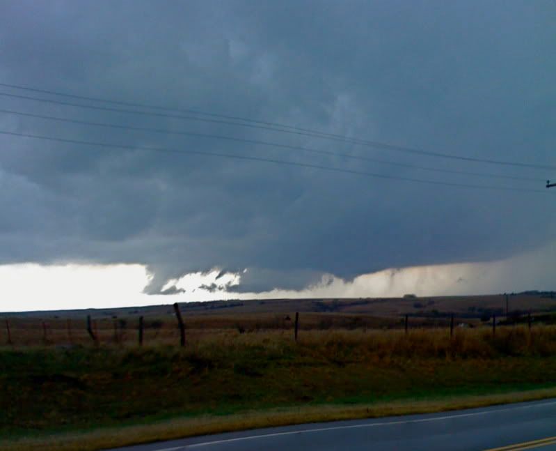
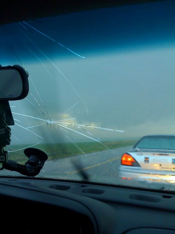
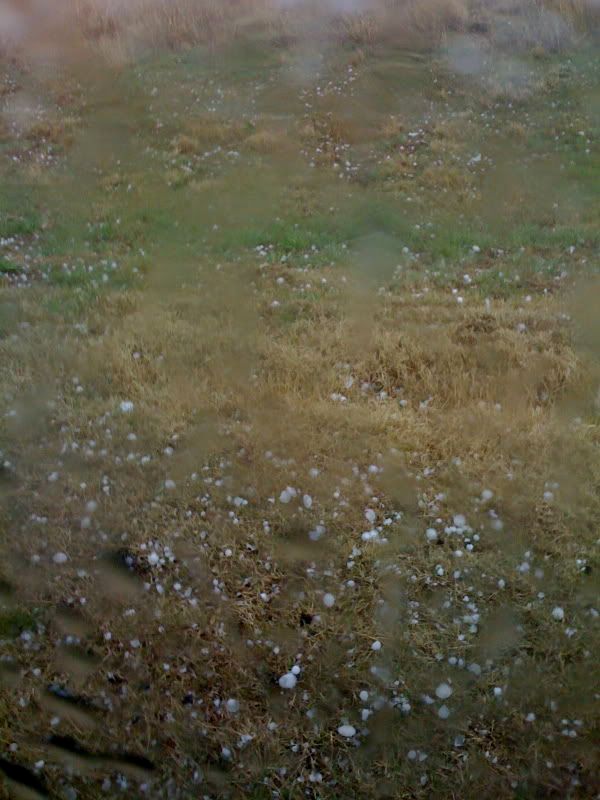
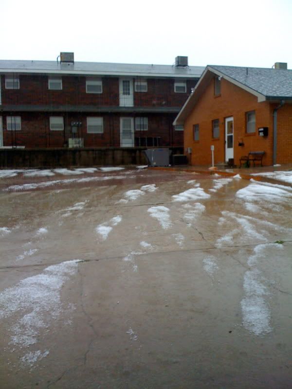
I was in Alva today for that cell, and let me tell you...It was CRAZY! We ran into hail as big as baseballs west of the city which destroyed the windshield and then we were pummeled with wind, rain and hail in the city itself. Pieces of roofing flew off across the street from where I was, hail covered the ground, the streets were flooding, and the wind whipped like crazy. Easily one of the top 3 most intense thunderstorms I have ever experienced.
0 likes
-
Ed Mahmoud
Re: S. Plains Severe April 17th to 19th?
Extremeweatherguy wrote:I was in Alva today for that cell, and let me tell you...It was CRAZY! We ran into hail as big as baseballs west of the city which destroyed the windshield and then we were pummeled with wind, rain and hail in the city itself. Pieces of roofing flew off across the street from where I was, hail covered the ground, the streets were flooding, and the wind whipped like crazy. Easily one of the top 3 most intense thunderstorms I have ever experienced.
Did you take pictures?
0 likes
-
Extremeweatherguy
- Category 5
- Posts: 11095
- Joined: Mon Oct 10, 2005 8:13 pm
- Location: Florida
Re: S. Plains Severe April 17th to 19th?
Ed Mahmoud wrote:Extremeweatherguy wrote:I was in Alva today for that cell, and let me tell you...It was CRAZY! We ran into hail as big as baseballs west of the city which destroyed the windshield and then we were pummeled with wind, rain and hail in the city itself. Pieces of roofing flew off across the street from where I was, hail covered the ground, the streets were flooding, and the wind whipped like crazy. Easily one of the top 3 most intense thunderstorms I have ever experienced.
Did you take pictures?
Yes. Here is some video I just posted on youtube...
http://www.youtube.com/watch?v=_La_ZJlGZCI
Also, here are a few still pictures...
0 likes
-
Extremeweatherguy
- Category 5
- Posts: 11095
- Joined: Mon Oct 10, 2005 8:13 pm
- Location: Florida
Re:
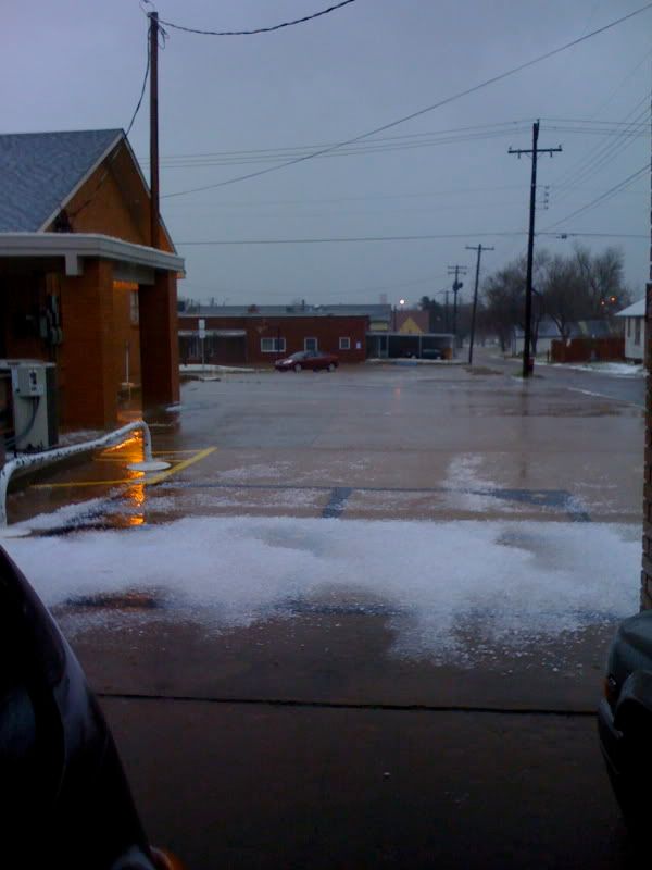
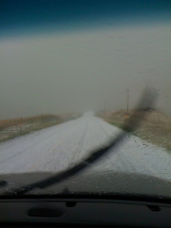
yes, there were several points yesterday when the road got like that. It was pretty scary, and made for driving more comparable to mid-winter. Cars were slipping and sliding everywhere.CajunMama wrote:Thanks for the video and pics ewg. Your kind of weather eh?In the video, there was one part where the entire road was covered in hail (at about 46 sec)?
Here is a picture of a hail-covered road that I forgot to post above..
0 likes
-
PTrackerLA

- Category 5
- Posts: 5281
- Age: 42
- Joined: Thu Oct 10, 2002 8:40 pm
- Location: Lafayette, LA
-
brunota2003
- S2K Supporter
- Posts: 9476
- Age: 35
- Joined: Sat Jul 30, 2005 9:56 pm
- Location: Stanton, KY...formerly Havelock, NC
- Contact:
-
Extremeweatherguy
- Category 5
- Posts: 11095
- Joined: Mon Oct 10, 2005 8:13 pm
- Location: Florida
Re:
Luckily it wasn't my car. It was one of the guys I was chasing with's car. I do feel pretty bad for him though, because I know I sure wouldn't have wanted that to happen to me. Unfortunately we had no idea that the hail would get that large when we first entered the storm. It looked like perhaps coin-sized to golfball-sized at the largest. Things changed in a hurry though, and we found ourselves in a situation where it was nearly impossible to escape the storm as it built over top of us. We were basically forced to ride out the massive hail attack and hope for the best. I am just thankful that baseball-sized was the largest it got. I couldn't even imagine what it would have been like had we seen anything larger than that.PTrackerLA wrote:Very nice pictures and footage. However your windshield and likely dents on your car = why I don't try to chase severe storms
0 likes
-
Dave
- Retired Staff
- Posts: 13442
- Age: 75
- Joined: Tue Aug 01, 2006 3:57 pm
- Location: Milan Indiana
- Contact:
BULLETIN - EAS ACTIVATION REQUESTED
TORNADO WARNING
NATIONAL WEATHER SERVICE BIRMINGHAM AL
821 PM CDT SUN APR 19 2009
THE NATIONAL WEATHER SERVICE IN BIRMINGHAM HAS ISSUED A
* TORNADO WARNING FOR...
COOSA COUNTY IN EAST CENTRAL ALABAMA...
THIS INCLUDES THE CITIES OF...ROCKFORD...KELLYTON...GOODWATER...
WEST CENTRAL TALLAPOOSA COUNTY IN EAST CENTRAL ALABAMA...
* UNTIL 915 PM CDT
* AT 820 PM CDT...NATIONAL WEATHER SERVICE DOPPLER RADAR WAS TRACKING
A TORNADO NEAR DOLLAR...OR 12 MILES WEST OF ROCKFORD...MOVING
NORTHEAST AT 25 MPH.
* THE TORNADO WILL BE NEAR...
LYLE AND MORIAH BY 835 PM CDT...
PENTONVILLE BY 845 PM CDT...
ROCKFORD AND BENTLEYVILLE BY 850 PM CDT...
COTTAGE GROVE BY 900 PM CDT...
CREWSVILLE AND HIGHWAY 9 AND HIGHWAY 22 BY 905 PM CDT...
BRADFORD AND HATCHET BY 910 PM CDT...
0 likes
-
Dave
- Retired Staff
- Posts: 13442
- Age: 75
- Joined: Tue Aug 01, 2006 3:57 pm
- Location: Milan Indiana
- Contact:
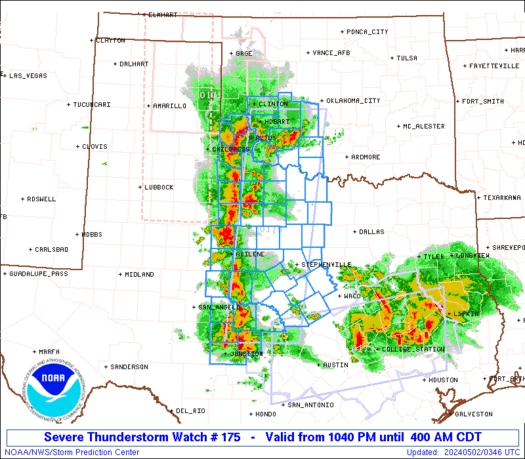
URGENT - IMMEDIATE BROADCAST REQUESTED
TORNADO WATCH NUMBER 175
NWS STORM PREDICTION CENTER NORMAN OK
855 PM EDT SUN APR 19 2009
THE NWS STORM PREDICTION CENTER HAS ISSUED A
TORNADO WATCH FOR PORTIONS OF
A LARGE PART OF NORTHERN AND CENTRAL GEORGIA
EFFECTIVE THIS SUNDAY NIGHT AND MONDAY MORNING FROM 855 PM UNTIL
300 AM EDT.
TORNADOES...HAIL TO 2 INCHES IN DIAMETER...THUNDERSTORM WIND
GUSTS TO 70 MPH...AND DANGEROUS LIGHTNING ARE POSSIBLE IN THESE
AREAS.
THE TORNADO WATCH AREA IS APPROXIMATELY ALONG AND 55 STATUTE
MILES EAST AND WEST OF A LINE FROM 45 MILES NORTH NORTHEAST OF
ROME GEORGIA TO 35 MILES SOUTHWEST OF MACON GEORGIA. FOR A
COMPLETE DEPICTION OF THE WATCH SEE THE ASSOCIATED WATCH OUTLINE
UPDATE (WOUS64 KWNS WOU5).
REMEMBER...A TORNADO WATCH MEANS CONDITIONS ARE FAVORABLE FOR
TORNADOES AND SEVERE THUNDERSTORMS IN AND CLOSE TO THE WATCH
AREA. PERSONS IN THESE AREAS SHOULD BE ON THE LOOKOUT FOR
THREATENING WEATHER CONDITIONS AND LISTEN FOR LATER STATEMENTS
AND POSSIBLE WARNINGS.
OTHER WATCH INFORMATION...CONTINUE...WW 173...WW 174...
DISCUSSION...SUPERCELLS OVER AL WILL CONTINUE INTO NWRN GA THIS
EVENING AS SHEAR PROFILES REMAIN FAVORABLE. WHILE AIR MASS IS ONLY
MARGINALLY UNSTABLE...GIVEN THE LARGE SCALE ASCENT AND SHEAR IN
ADVANCE OF UPPER TROUGH...EXISTING SUPERCELLS INCLUDING THREAT OF
TORNADOES WILL PERSIST FOR SEVERAL MORE HOURS AS THEY TRACK EWD
ACROSS WRN GA.
0 likes
-
Dave
- Retired Staff
- Posts: 13442
- Age: 75
- Joined: Tue Aug 01, 2006 3:57 pm
- Location: Milan Indiana
- Contact:
BULLETIN - EAS ACTIVATION REQUESTED
TORNADO WARNING
NATIONAL WEATHER SERVICE HUNTSVILLE AL
843 PM CDT SUN APR 19 2009
THE NATIONAL WEATHER SERVICE IN HUNTSVILLE HAS ISSUED A
* TORNADO WARNING FOR...
SOUTHERN DEKALB COUNTY IN NORTHEAST ALABAMA...
EAST CENTRAL MARSHALL COUNTY IN NORTHEAST ALABAMA...
* UNTIL 915 PM CDT
* AT 843 PM CDT...NATIONAL WEATHER SERVICE DOPPLER RADAR INDICATED A
SEVERE THUNDERSTORM CAPABLE OF PRODUCING A TORNADO NEAR WHITON...OR
ABOUT 10 MILES NORTHEAST OF ALBERTVILLE...MOVING EAST AT 35 MPH.
* LOCATIONS NEAR THE PATH OF THIS TORNADO INCLUDE...
CHIGGER HILL.
LAKEVIEW.
PEEKS CORNER.
LEBANON.
COLLBRAN.
0 likes
-
Dave
- Retired Staff
- Posts: 13442
- Age: 75
- Joined: Tue Aug 01, 2006 3:57 pm
- Location: Milan Indiana
- Contact:
BULLETIN - EAS ACTIVATION REQUESTED
TORNADO WARNING
NATIONAL WEATHER SERVICE BIRMINGHAM AL
848 PM CDT SUN APR 19 2009
THE NATIONAL WEATHER SERVICE IN BIRMINGHAM HAS ISSUED A
* TORNADO WARNING FOR...
NORTHERN BULLOCK COUNTY IN SOUTHEAST ALABAMA...
THIS INCLUDES THE CITY OF UNION SPRINGS...
SOUTHERN MACON COUNTY IN SOUTHEAST ALABAMA...
* UNTIL 930 PM CDT
*AT 847 PM CDT...LOCAL LAW ENFORCEMENT REPORTED A TORNADO NEAR
FRANKLIN FIELD...OR 10 MILES WEST OF UNION SPRINGS...MOVING
NORTHEAST AT 30 MPH.
* THE TORNADO WILL BE NEAR...
FRANKLIN FIELD AND 6 MILES SOUTHEAST OF HARDAWAY BY 855 PM CDT...
6 MILES NORTHWEST OF UNION SPRINGS BY 905 PM CDT...
DAVISVILLE BY 915 PM CDT...
6 MILES NORTHWEST OF GUERRYTON BY 930 PM CDT...
0 likes
-
Dave
- Retired Staff
- Posts: 13442
- Age: 75
- Joined: Tue Aug 01, 2006 3:57 pm
- Location: Milan Indiana
- Contact:
BULLETIN - EAS ACTIVATION REQUESTED
TORNADO WARNING
NATIONAL WEATHER SERVICE BIRMINGHAM AL
901 PM CDT SUN APR 19 2009
THE NATIONAL WEATHER SERVICE IN BIRMINGHAM HAS ISSUED A
* TORNADO WARNING FOR...
SOUTHEASTERN BLOUNT COUNTY IN CENTRAL ALABAMA...
NORTHERN ST. CLAIR COUNTY IN CENTRAL ALABAMA...
THIS INCLUDES THE CITY OF SPRINGVILLE...
WEST CENTRAL CALHOUN COUNTY IN EAST CENTRAL ALABAMA...
SOUTHWESTERN ETOWAH COUNTY IN NORTHEAST ALABAMA...
THIS INCLUDES THE CITY OF RAINBOW CITY...
* UNTIL 930 PM CDT
* AT 900 PM CDT...NATIONAL WEATHER SERVICE DOPPLER RADAR INDICATED A
SEVERE THUNDERSTORM CAPABLE OF PRODUCING A TORNADO 6 MILES NORTH OF
SPRINGVILLE...MOVING EAST AT 35 MPH.
* OTHER LOCATIONS IN THE WARNING INCLUDE BUT ARE NOT LIMITED TO
ASHVILLE...STEELE...OHATCHEE AND ATTALLA
0 likes
Return to “USA & Caribbean Weather”
Who is online
Users browsing this forum: txtwister78 and 165 guests