The BoM can't even agree with itself, apparently:
HIGH SEAS WEATHER WARNING FOR METAREA 10 ISSUED BY THE
AUSTRALIAN BUREAU OF METEOROLOGY, SYDNEY
0524UTC 20 APRIL 2009.
GALE WARNING FOR SOUTHEASTERN AREA.
Please Be Aware:
Wind gusts may be a further 40 per cent stronger than the averages
given here, and maximum waves may be up to twice the height.
SITUATION
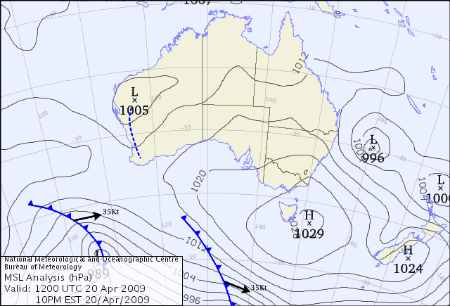
AT 04200400UTC A COMPLEX LOW PRESSURE SYSTEM [990HPA] WITH MAIN
CENTRE NEAR 30S160.5E, EXPECTED NEAR 29S161E [990HPA] AT 04201200UTC
AND NEAR 29S162E [990HPA] AT 04202100UTC.
AREA AFFECTED
28S155.5E TO 28S160E TO 34S160E TO 34S155E TO 28S155.5E
FORECAST
SE/SW WINDS 34/40 KNOTS [CLOCKWISE AROUND THE LOW]. WINDS REACHING
40/47 KNOTS WITHIN 120NM TO THE SW OF THE LOW CENTRE.
VERY ROUGH TO HIGH SEAS. MODERATE TO HEAVY SWELL.
REMARKS
GALES GRADUALLY CONTRACTING NORTH.
WEATHER SYDNEY
HIGH SEAS WEATHER WARNING FOR METAREA 10 ISSUED BY THE AUSTRALIAN BUREAU OF
METEOROLOGY, BRISBANE 0827 UTC 20 April 2009
GALE FORCE WIND WARNING FOR NORTH EASTERN AREA
SITUATION
A low, central pressure of 994 hpa, was situated near 29S 160E at 200730 UTC,
and was moving slowly east. The low is expected near 29S 161E at 201800 UTC and
29S 162E at 210600 UTC.
AREA AFFECTED
Within 180 nautical miles of the low in the northeastern area of warning
responsibility.
FORECAST
Clockwise winds 30/35 knots. Rough to very rough seas on a moderate to heavy
swell.
REMARKS
All ships in the area please send weather reports every three hours. Regular
weather observing ships use normal channels. Other ships please use either
email to
marwxqld@bom.gov.au or fax to +61732200221 or satellite to SAC 41
through Land Earth Station Perth 222.
WEATHER BRISBANE