Latest from SPC. Looks like we may have some rough weather ahead...
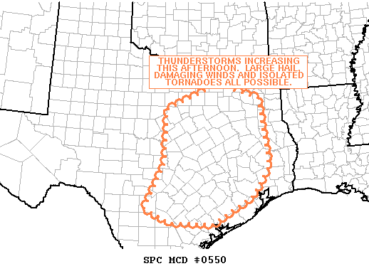
MESOSCALE DISCUSSION 0550
NWS STORM PREDICTION CENTER NORMAN OK
1207 PM CDT FRI APR 24 2009
AREAS AFFECTED...CENTRAL AND EASTERN TX
CONCERNING...SEVERE POTENTIAL...WATCH LIKELY
VALID 241707Z - 241900Z
THUNDERSTORMS WILL BECOME MORE WIDESPREAD ACROSS PORTIONS OF CENTRAL
AND EASTERN TX THROUGH LATE AFTERNOON. SOME STORMS WILL PRODUCE
LARGE HAIL...DAMAGING WINDS AND POSSIBLY ISOLATED TORNADOES.
WATER VAPOR IMAGERY SHOWS THE MID-LEVEL SHORTWAVE TROUGH AND
ASSOCIATED MINUS 14-MINUS 16 DEG C 500 MB TEMPERATURES CONTINUING AN
EAST-NORTHEAST TREK ACROSS CENTRAL TX EARLY THIS AFTERNOON. THUS
FAR...CONSIDERABLE MID-LEVEL CONVECTION HAS BEEN NOTED OVER THE
REGION AND THIS HAS LIKELY CONDITIONED/MOISTENED THE BASE OF THE
ELEVATED MIXED LAYER. ADDITIONAL LOW-LEVEL HEATING WILL CONTINUE TO
ERODE CONVECTIVE INHIBITION AND THUNDERSTORMS SHOULD BEGIN TO
INCREASE IN ERNEST AFTER 18Z OR SO. LOW-LEVEL FOCI CONTINUE TO BE
WEAK...THOUGH BASED ON SURFACE ANALYSIS...MASS CONVERGENCE APPEARS
TO BE ENHANCED ALONG THE ESCARPMENT NORTHEAST INTO PARTS OF
NORTH-CENTRAL TX.
STRONGEST VERTICAL SHEAR WILL EXIST ACROSS CENTRAL TX WHERE 35-40
KTS OF WESTERLY MID-LEVEL FLOW WRAPS AROUND THE AFOREMENTIONED
TROUGH. BUT...MAGNITUDE OF LAPSE RATES AND INCREASING BOUNDARY
LAYER MOISTURE WILL LIKELY YIELD SEVERE MULTICELLS...THOUGH BRIEF
SUPERCELL CHARACTERISTICS ARE POSSIBLE...PARTICULARLY FROM THE HILL
COUNTRY NORTHEAST INTO EAST-CENTRAL TX. OTHERWISE... EVOLUTION INTO
CLUSTERS/LINE-SEGMENTS WILL BE LIKELY BY LATE AFTERNOON WITH
OCCASIONAL BOWING. AT THIS TIME...EXPECT LARGE HAIL WILL BE THE
PRIMARY SEVERE THREAT WITH DAMAGING WIND RISKS INCREASING WITH TIME.
HOWEVER...ISOLATED TORNADOES CANNOT BE RULED OUT...ESPECIALLY WITH
ANY SUSTAINED SUPERCELL STRUCTURES.
..RACY.. 04/24/2009
ATTN...WFO...LCH...SHV...HGX...FWD...CRP...EWX...SJT...
Edit to add latest update from Jeff Lindner...
SPC has upgraded a large part of SE TX mainly W of I-45 to a slight risk for severe thunderstorms this afternoon and evening.
Shortwave currently over N TX extending back to low/mid level circulation in NE old MX west of Laredo. CRP AM sounding has come in very unstable with CAPE of 3500 and LI around -8, but capped around 800mb. LCH sounding is much more stable. CRP capping can be broken with a surface temp in the range of 80-85, and with breaks in the overcast developing and surface obs. already pushing 80…we should be able to break through the cap in a few locations by late afternoon.
Pent up surface energy will be released once capping is removed allowing vigorous updrafts and the possibility of severe convection. Still no surface focus to fire off activity along however favored area is along a College Station to Victoria line this afternoon/evening where intense low level jet appears to be intersecting some kind of mid level boundary noted on visible satellite images extending from Galveston toward Victoria. Strong cell south of San Antonio currently appears to have generated on this feature.
Widespread widespread thunderstorms are not expected the few that do develop have the potential to become severe with large hail and damaging winds.
May need to add in higher rain chances for Saturday afternoon also as another impulse currently approaching Baja ejects over the state.


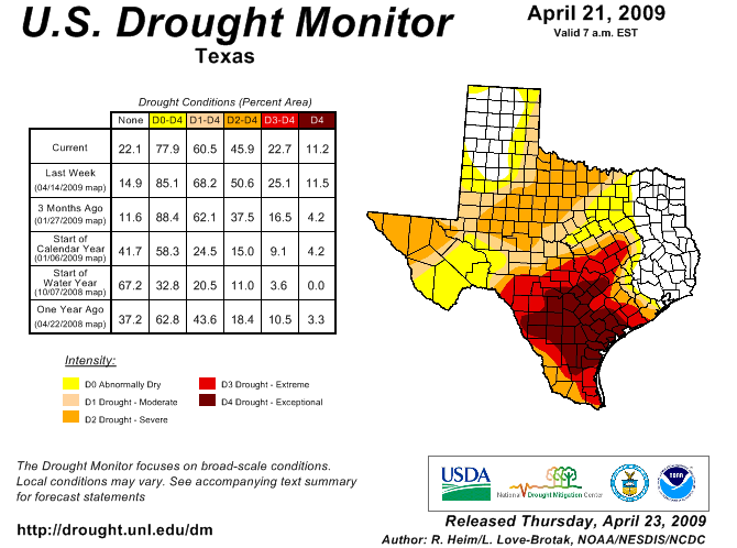
No more drought for us!