TROPICAL CYCLONE TECHNICAL BULLETIN: AUSTRALIA - NORTHERN REGION
Issued by DARWIN TROPICAL CYCLONE WARNING CENTRE
at: 1940 UTC 26/04/2009
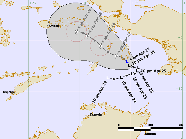
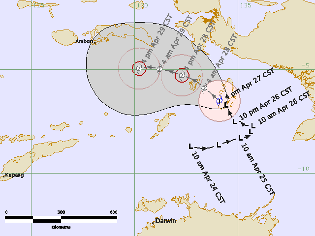
Name: Tropical Low
Identifier: 23U
Data At: 1800 UTC
Latitude: 7.1S
Longitude: 134.6E
Location Accuracy: within 50 nm [95 km]
Movement Towards: north northwest [334 deg]
Speed of Movement: 4 knots [8 km/h]
Maximum 10-Minute Wind: 30 knots [55 km/h]
Maximum 3-Second Wind Gust: 45 knots [85 km/h]
Central Pressure: 1002 hPa
Radius of 34-knot winds NE quadrant:
Radius of 34-knot winds SE quadrant:
Radius of 34-knot winds SW quadrant:
Radius of 34-knot winds NW quadrant:
Radius of 48-knot winds NE quadrant:
Radius of 48-knot winds SE quadrant:
Radius of 48-knot winds SW quadrant:
Radius of 48-knot winds NW quadrant:
Radius of 64-knot winds:
Radius of Maximum Winds:
Dvorak Intensity Code: T2.0/2.5/D0.5/24HRS
Pressure of outermost isobar: 1008 hPa
Radius of outermost closed isobar: 120 nm [220 km]
Storm Depth: Medium
FORECAST DATA
Date/Time : Location : Loc. Accuracy: Max Wind : Central Pressure
[UTC] : degrees : nm [km]: knots[km/h]: hPa
+12: 27/0600: 6.5S 133.6E: 080 [150]: 035 [065]: 1001
+24: 27/1800: 5.5S 132.0E: 110 [205]: 040 [075]: 998
+36: 28/0600: 4.6S 130.8E: 140 [265]: 040 [075]: 997
+48: 28/1800: 4.2S 129.7E: 175 [325]: 040 [075]: 997
+60: 29/0600: 4.0S 128.5E: 220 [410]: 040 [075]: 998
+72: 29/1800: 3.9S 127.5E: 270 [500]: 040 [075]: 997
REMARKS:
Low is continuing movement to northnorthwest under the influence of the midlevel
ridge. Position is based on reasonable agreement between latest IR and 3.9
micron imagery and 89 GHz AMSUB imagery at 1623UTC after navigation correction.
Environment for development appears favourable. However, structure of the
system in satellite imagery has waned somewhat over recent hours, with decreased
curvature in convective bands. Dvorak FT of 2.0 based on DT 2.0 from 0.3 spiral
wrap. MET and PT agree. CI held up at 2.5.
Model prognoses are in good agreement on continued movement towards the
northwest over the coming days, with system in easterly steering north of the
mid-level ridge. Development forecast, based on extrapolation of slow
development trend over last 24 hours, is for TC formation within next 24 hours.
However, development may be hindered by unfavourble interactions with islands,
and in the longer term vertical shear will become unfavourable as the system
moves north of the upper ridge axis.
Copyright Commonwealth of Australia
==
The next bulletin for this system will be issued by: 27/0130 UTC by Darwin TCWC.