Atlantic Sea Surface Temperatures and Anomalies

This is the general tropical discussion area. Anyone can take their shot at predicting a storms path.

Moderator: S2k Moderators

Forum rules

The posts in this forum are NOT official forecasts and should not be used as such. They are just the opinion of the poster and may or may not be backed by sound meteorological data. They are NOT endorsed by any professional institution or STORM2K. For official information, please refer to products from the National Hurricane Center and National Weather Service.

Help Support Storm2K
Message
Author
User avatar
gatorcane
S2K Supporter
S2K Supporter
Posts: 23691
Age: 47
Joined: Sun Mar 13, 2005 3:54 pm
Location: Boca Raton, FL

#41 Postby gatorcane » Tue Apr 28, 2009 11:38 am

anomalies are trending above normal now across most of the Western Atlantic now, reminiscent of 2005 if these trends continue.

It supports an active season. I'd be shocked if we are near average this season (those of you on the low side who want to revise your storm2k numbers, I would do so while you can :wink:)

Image
0 likes   

tolakram
Admin
Admin
Posts: 20009
Age: 62
Joined: Sun Aug 27, 2006 8:23 pm
Location: Florence, KY (name is Mark)

Re: Atlantic Sea Surface Temperatures and Anomalies

#42 Postby tolakram » Tue Apr 28, 2009 12:52 pm

I won't change. :)

2005 was a fluke. Low shear, warm waters and disturbances in the right place at the right time. Even if we get warm waters there is no firm prediction yet on shear or if we'll see a lot of disturbances. I think we'll see increased shear from a weak Nino plus African Dust to dampen development.

But really, who knows!
0 likes   

User avatar
cycloneye
Admin
Admin
Posts: 145336
Age: 68
Joined: Thu Oct 10, 2002 10:54 am
Location: San Juan, Puerto Rico

Re: Atlantic Sea Surface Temperatures and Anomalies

#43 Postby cycloneye » Sat May 02, 2009 4:59 pm

The Tropical Cyclone Heat Potential factor is important for systems to grow rapidly.But so far 2009 TCHP is less than in 2008 although its still early.

2008

Image

2009

Image
0 likes   

jinftl
Category 5
Category 5
Posts: 4312
Joined: Tue Aug 31, 2004 4:47 pm
Location: fort lauderdale, fl

Re: Atlantic Sea Surface Temperatures and Anomalies

#44 Postby jinftl » Sat May 02, 2009 5:26 pm

Obviously as sea temps rise,TCHP will increase overall...TCHP is a factor to look at in assessing if rapid intensification of a system is possible....but systems can develop and maintain themselves in area of low TCHP as long as the water closest to the surface is warm enough (generally 80+).

Raises an interesting pre-season question...where do we stand now compared to average for the time of year...latest Heat Anomaly map shows that the 300m depth of water has higher heat content than normal across the Gulf and part of the Atlantic south of 15N. Areas to the north in the central Atlantic are below normal. The Gulf anomalies could lend to early development in that area if it persists....by June the Gulf will be in the 80s (or rapidly approaching)...that's not the question...but if the depth of warm water and the resulting TCHP are higher than normal....could be a factor favoring early storms.

Image
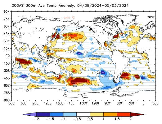
http://www.cpc.ncep.noaa.gov/products/G ... 00.30d.gif

Overall, compared to the same time last year, the Gulf is a bit warmer..as is the atlantic off the east-central florida coast. Bay of Campeche is significantly warmer than last year....water already in the 80s.

May 1, 2008:
Image

May 1, 2009:
Image


cycloneye wrote:The Tropical Cyclone Heat Potential factor is important for systems to grow rapidly.But so far 2009 TCHP is less than in 2008 although its still early.
0 likes   

User avatar
cycloneye
Admin
Admin
Posts: 145336
Age: 68
Joined: Thu Oct 10, 2002 10:54 am
Location: San Juan, Puerto Rico

Re: Atlantic Sea Surface Temperatures and Anomalies

#45 Postby cycloneye » Wed May 06, 2009 11:15 am

The Loop Current is expanding to the NW,also the Bay of Campeche is warming.

Image
0 likes   

jinftl
Category 5
Category 5
Posts: 4312
Joined: Tue Aug 31, 2004 4:47 pm
Location: fort lauderdale, fl

Re: Atlantic Sea Surface Temperatures and Anomalies

#46 Postby jinftl » Wed May 06, 2009 11:44 am

The Gulf, Bay of Campeche, and NW Caribbean are warmer right now than they were a year ago..quite a bit in some places. Given that this is the area to look for early season development....water temps will not be a deterrent to develop if all the other pieces needed come together just right.

Image

Image
0 likes   

Ed Mahmoud

Re: Atlantic Sea Surface Temperatures and Anomalies

#47 Postby Ed Mahmoud » Fri May 08, 2009 11:06 am

Seems like sunny and warm (low 90s inland) days are getting the near Texas Gulf warmer. Not quite there yet, but should be by June 1.

Galveston Buoy.
Image
0 likes   

JonathanBelles
Professional-Met
Professional-Met
Posts: 11430
Age: 35
Joined: Sat Dec 24, 2005 9:00 pm
Location: School: Florida State University (Tallahassee, FL) Home: St. Petersburg, Florida
Contact:

#48 Postby JonathanBelles » Sun May 10, 2009 3:15 pm

Water temps here have cracked the 80 degree mark.
0 likes   

Ed Mahmoud

Re:

#49 Postby Ed Mahmoud » Sun May 10, 2009 3:20 pm

fact789 wrote:Water temps here have cracked the 80 degree mark.


Looks like all the Gulf will be warm enough for TCs by June 1, but I don't think that is that unusual.


Check out this date in 2006...

Image
0 likes   

User avatar
Ivanhater
Storm2k Moderator
Storm2k Moderator
Posts: 11161
Age: 38
Joined: Fri Jul 01, 2005 8:25 am
Location: Pensacola

Re: Atlantic Sea Surface Temperatures and Anomalies

#50 Postby Ivanhater » Thu May 14, 2009 10:22 pm

May 13

Image
0 likes   

User avatar
cycloneye
Admin
Admin
Posts: 145336
Age: 68
Joined: Thu Oct 10, 2002 10:54 am
Location: San Juan, Puerto Rico

Re: Atlantic Sea Surface Temperatures and Anomalies

#51 Postby cycloneye » Mon May 18, 2009 7:13 am

Latest Reynolds ssts and anomalies update shows the MDR for the most part slightly below average,Caribbean on average,GOM is above average and the North-Central Atlantic is above average.The biggest change in this update was the Eastern Atlantic,where waters are more warmer than in the past 3 months when they were well below average.

Image
0 likes   

User avatar
cycloneye
Admin
Admin
Posts: 145336
Age: 68
Joined: Thu Oct 10, 2002 10:54 am
Location: San Juan, Puerto Rico

Re: Atlantic Sea Surface Temperatures and Anomalies

#52 Postby cycloneye » Sat May 23, 2009 3:39 pm

The Western Caribbean has increased heat potential.

Image
0 likes   

User avatar
cycloneye
Admin
Admin
Posts: 145336
Age: 68
Joined: Thu Oct 10, 2002 10:54 am
Location: San Juan, Puerto Rico

Re: Atlantic Sea Surface Temperatures and Anomalies

#53 Postby cycloneye » Mon May 25, 2009 7:37 am

The Eastern Atlantic for the past 5 months has been the area in the whole basin with very below normal ssts and anomalies.But in the past 2 weeks,those waters haved warmed to normal levels with some small pockets of slightly above average temps.Lets see if this warming trend continues in the comming weeks or this is something temporary.

Image
0 likes   

User avatar
KWT
Category 5
Category 5
Posts: 31415
Joined: Tue Aug 17, 2004 11:02 am
Location: UK!!!

#54 Postby KWT » Mon May 25, 2009 1:05 pm

I suspect the higher temps near 0 degrees latitude may be feeding northwards warming up the Eastern Atlantic, along with a shift in weather patterns.
0 likes   

User avatar
hurricanetrack
HurricaneTrack.com
HurricaneTrack.com
Posts: 1781
Joined: Tue Dec 02, 2003 10:46 pm
Location: Wilmington, NC
Contact:

#55 Postby hurricanetrack » Mon May 25, 2009 11:41 pm

Yeah, what is up with that band of significantly warmer than avg water temps in the Atlantic along the Equator? Anyone venture to guess why we are seeing that?

And, as noted in other posts on this topic, the eastern Atlantic has gone from quite a bit below normal to pretty much normal overall- with some areas of .5 - 1.0 C above normal. Of course, let's see what this looks like come August 15 or so. At that point, it will really matter.
0 likes   

User avatar
cycloneye
Admin
Admin
Posts: 145336
Age: 68
Joined: Thu Oct 10, 2002 10:54 am
Location: San Juan, Puerto Rico

Re: Atlantic Sea Surface Temperatures and Anomalies

#56 Postby cycloneye » Sun May 31, 2009 2:59 pm

Caribbean Sea waters are warming in a steady phase for the past 3 weeks.Of course,the warm waters is not the only factor that causes Cyclone formations,but is one of the most important ones.

Image

http://www.aoml.noaa.gov/phod/cyclone/data/at.html
0 likes   

User avatar
cycloneye
Admin
Admin
Posts: 145336
Age: 68
Joined: Thu Oct 10, 2002 10:54 am
Location: San Juan, Puerto Rico

Re: Atlantic Sea Surface Temperatures and Anomalies

#57 Postby cycloneye » Mon Jun 01, 2009 6:59 am

Less strong high pressure in the past 2 weeks has led to warmer anomalies in the Central Atlantic as you can see in the latest graphic from Reynolds.

Image
0 likes   

User avatar
cycloneye
Admin
Admin
Posts: 145336
Age: 68
Joined: Thu Oct 10, 2002 10:54 am
Location: San Juan, Puerto Rico

Re: Atlantic Sea Surface Temperatures and Anomalies

#58 Postby cycloneye » Wed Jun 03, 2009 12:09 pm

Notice in the GOM loop that it starts less warm because of invest 90L cloud cover at that time cooling the waters,but after that it warms a lot.

Image
0 likes   

jinftl
Category 5
Category 5
Posts: 4312
Joined: Tue Aug 31, 2004 4:47 pm
Location: fort lauderdale, fl

Re: Atlantic Sea Surface Temperatures and Anomalies

#59 Postby jinftl » Fri Jun 05, 2009 2:05 pm

Bathwater temps appearing over the keys up the west coast to the tampa area

Image
0 likes   

User avatar
cycloneye
Admin
Admin
Posts: 145336
Age: 68
Joined: Thu Oct 10, 2002 10:54 am
Location: San Juan, Puerto Rico

Re: Atlantic Sea Surface Temperatures and Anomalies

#60 Postby cycloneye » Thu Jun 11, 2009 2:43 pm

Anomalies warmed a tad in the Eastern Atlantic this week.

Image

http://www.osdpd.noaa.gov/PSB/EPS/SST/climo.html
0 likes   


Return to “Talkin' Tropics”

Who is online

Users browsing this forum: No registered users and 38 guests