Retitled EWG tornado chase thread- go to page 2!

U.S. & Caribbean Weather Discussions and Severe Weather Events

Moderator: S2k Moderators

Forum rules

The posts in this forum are NOT official forecast and should not be used as such. They are just the opinion of the poster and may or may not be backed by sound meteorological data. They are NOT endorsed by any professional institution or STORM2K.

Help Support Storm2K
Message
Author
Ed Mahmoud

Retitled EWG tornado chase thread- go to page 2!

#1 Postby Ed Mahmoud » Thu May 07, 2009 8:31 am

Right in his backyard.

Image

snip

MEANWHILE...STRONG SURFACE HEATING IS EXPECTED TO DEVELOP ACROSS
MUCH OF THE SRN HALF OF OK AND WWD THROUGH TX PANHANDLE TO SERN
CO/SWRN KS ALONG AND S OF MORNING MCS. STRENGTHENING SLY LLJ INTO
SRN OK DURING THE LATE AFTERNOON WILL INCREASE CONVERGENCE ALONG THE
E-W OUTFLOW BOUNDARY. THIS COMBINED WITH FORCING FOR ASCENT WITHIN
ENTRANCE REGION OF A MID LEVEL JET EXPECTED OVER THE OZARKS FRIDAY
AFTERNOON WILL SUPPORT TSTM DEVELOPMENT ACROSS MUCH OF CENTRAL/ERN
OK. VERY STEEP LAPSE RATES /EXCEEDING 8 C/KM/...SURFACE HEATING AND
RICH MOISTURE /SURFACE DEWPOINTS IN THE LOWER 70S/ WILL SUPPORT A
VERY UNSTABLE AIR MASS WITH MLCAPE EXCEEDING 3000 J/KG ACROSS
CENTRAL OK. INCREASING WLY MID LEVEL WINDS ACROSS THIS REGION BY
PEAK HEATING WILL STRENGTHEN DEEP LAYER SHEAR FOR SUPERCELLS...WITH
AN ATTENDANT THREAT FOR TORNADOES...VERY LARGE HAIL AND DAMAGING WINDS. GIVEN THE LIKELIHOOD FOR TSTM DEVELOPMENT WITHIN THIS VERY UNSTABLE/ STRONGLY SHEAR ENVIRONMENT...PARTS OF CENTRAL/ERN OK HAVE
BEEN UPGRADED TO A MODERATE RISK.
Last edited by Ed Mahmoud on Tue May 12, 2009 10:42 am, edited 2 times in total.
0 likes   

Ed Mahmoud

Re: Is Extreme Weather Guy chasing tomorrow?

#2 Postby Ed Mahmoud » Thu May 07, 2009 8:37 am

0Z GFS shows precip breaking out late afternoon.

7 pm GFS forecast soundings for Durant, South of the front, and capped, and OKC, very near the front.

Image

Image


TWC has a crew at OUN to follow some tornado research project, which I think starts Monday. Maybe they'll get some bonus early coverage tomorrow.
0 likes   

Ed Mahmoud

Re: Is Extreme Weather Guy chasing tomorrow?

#3 Postby Ed Mahmoud » Thu May 07, 2009 11:10 am

GFS amd NAM both suggests storm initiation near EWG very late afternoon, before sunset for good backlighting.

Both suggest rather weak wind fields just North of the warm front, which lies somewhere near Duncan, home of Halliburton. I worked for Halliburton at ARA in Louisiana back in the 1990s, before they became Jack Bauer's evil nemesis. Just kidding. But I did work for HAL. And BHI. And SLB. Service companies- no fun. Working at an oil company, better. But subject to the same economic cycles. I got laid off from Baker Hughes INTEQ, where I worked as an offshore logging while drilling engineer, in the Summer of 1998. 2 weeks severance, and they took my 1998 Ford F-150 with the V-8 Triton engine company vehicle. $10 oil is not my friend.

Anyway, back on topic, weak low level wind fields, but fantastic CAPE and truly awesome mid level instability.

Forecast sounding for Halliburton Field.

Image
0 likes   

Ed Mahmoud

Re: Is Extreme Weather Guy chasing tomorrow?

#4 Postby Ed Mahmoud » Thu May 07, 2009 11:18 am

I refer the casual reader to the 1997 Jarrell, TX F-5 tornado, for an example of a high CAPE (close to 6000 J/Kg) low shear tornado. IIRC, Texas A&M did some computer modeling, and a weak wind shift just West of I-35 was the secret ingredient for the tornadic cells which built from NE to SW, kind of the opposite of normal tornadoes.

Modeled with no weak wind shift, a strong thunderstorm would form, but would tend to collapse after about an hour.

Forget where I read that.

Anyway, Google search results for the Jarrell tornado.

Jarrell tornado in organizing stage
Image

Mature:
Image
0 likes   

User avatar
Extremeweatherguy
Category 5
Category 5
Posts: 11095
Joined: Mon Oct 10, 2005 8:13 pm
Location: Florida

Re: Is Extreme Weather Guy chasing tomorrow?

#5 Postby Extremeweatherguy » Thu May 07, 2009 12:10 pm

I might be chasing tomorrow, I'm just not 100% sure yet. Luckily, with the threat being so close to home, I'll be able to make up my mind at the last minute.
0 likes   

Ed Mahmoud

Re: Is Extreme Weather Guy chasing tomorrow?

#6 Postby Ed Mahmoud » Thu May 07, 2009 12:24 pm

Extremeweatherguy wrote:I might be chasing tomorrow, I'm just not 100% sure yet. Luckily, with the threat being so close to home, I'll be able to make up my mind at the last minute.


I have no idea who the chaser was the other day for the bust tornado watch just West of Dallas. Lone cell in Stephens and Palo Pinto county. Lasted several hours, occasionally showed rotation on the radar. Spotter reported windshield broken by 4 to 5 inch hail.


I hope he got pictures.
0 likes   

User avatar
vbhoutex
Storm2k Executive
Storm2k Executive
Posts: 29096
Age: 73
Joined: Wed Oct 09, 2002 11:31 pm
Location: Cypress, TX
Contact:

Re: Is Extreme Weather Guy chasing tomorrow?

#7 Postby vbhoutex » Thu May 07, 2009 2:25 pm

Ed Mahmoud wrote:
Extremeweatherguy wrote:I might be chasing tomorrow, I'm just not 100% sure yet. Luckily, with the threat being so close to home, I'll be able to make up my mind at the last minute.


I have no idea who the chaser was the other day for the bust tornado watch just West of Dallas. Lone cell in Stephens and Palo Pinto county. Lasted several hours, occasionally showed rotation on the radar. Spotter reported windshield broken by 4 to 5 inch hail.


I hope he got pictures.

I saw pictures of the hail damage to the vehicle(probably on TV), but I don't remember any other pics with it.
0 likes   

Ed Mahmoud

Re: Is Extreme Weather Guy chasing tomorrow?

#8 Postby Ed Mahmoud » Thu May 07, 2009 10:44 pm

New NAM- after morning MCS clears out, more storms form, looks semi-linear in 3 hour PSU e-Wall images, perhaps suggesting (as discussed by NWS OUN) outflow boundary from morning storms is new focus, storms backbuild/drift almost to DFW before poofing.

Hour 0 NAM skew-T
Image

Actual sounding at 0Z
Image

At least on initialization, looks like NAM may actually have a bit too much cap. Not a huge error, by amateur eyeball.

FWD/FTW looks closer
Image
Image

Durant, OK, near the action per NAM- not much of a cap at all...

Image

Winds a tad weak, but instability is quite healthy and local boundaries/storm interactions, as they say on TV, could be enough for a spin-up or two.

OT
Looking at NAM 84 hour total rainfall, the Mid-South has more flooding issues ahead.
Image
0 likes   

User avatar
Extremeweatherguy
Category 5
Category 5
Posts: 11095
Joined: Mon Oct 10, 2005 8:13 pm
Location: Florida

#9 Postby Extremeweatherguy » Fri May 08, 2009 1:18 am

The latest SPC outlook is causing me to think that chasing tomorrow is a no go. The highest severe risk area is in a poor part of the state for chasing and it is only a SLT risk overall. It would take at least a solid MDT risk to get me to go chase in that part of the state.
0 likes   

Ed Mahmoud

Re:

#10 Postby Ed Mahmoud » Fri May 08, 2009 7:03 am

Extremeweatherguy wrote:The latest SPC outlook is causing me to think that chasing tomorrow is a no go. The highest severe risk area is in a poor part of the state for chasing and it is only a SLT risk overall. It would take at least a solid MDT risk to get me to go chase in that part of the state.


Maybe the 8 am outlook will be more favorable for the flat, treeless plains.


I've spent some time in Tulsa and Eastern OK, which, storm spotting aside, is much more scenic with trees and hills.
0 likes   

Ed Mahmoud

Re: Is Extreme Weather Guy chasing tomorrow?

#11 Postby Ed Mahmoud » Fri May 08, 2009 10:18 am

OKC is welly and truly capped to storms, a cap of forged steel.

But if somehow a passing weak disturbance, or an outflow boundary from the morning MCV were to fire a storm against all odds, it should be a stout one...


Image
0 likes   

Ed Mahmoud

Re: Is Extreme Weather Guy chasing tomorrow?

#12 Postby Ed Mahmoud » Fri May 08, 2009 10:46 am

FWIW, new NAM busts the cap at Abilene just at/before 7 pm with temps in the low 100sF (upper 30sº), then drifts a lone supercell towards Waco which poofs in the early morning hours.


Unimpressive forecast winds, but a boatload of mid-level instability.

I've got a good feel for the basic idea of evaporative cooling and downbursts, but not specifics like D-CAPE, but surface temps around 40º and dewpoints of 20º, or about 35ºF T/Td spread would seem favorable for damaging straightline winds, even if the hail and tornado threat seems small.

Image
0 likes   

User avatar
southerngale
Retired Staff
Retired Staff
Posts: 27418
Joined: Thu Oct 10, 2002 1:27 am
Location: Southeast Texas (Beaumont area)

Re: Is Extreme Weather Guy chasing tomorrow?

#13 Postby southerngale » Fri May 08, 2009 2:50 pm

Ed Mahmoud wrote:Right in his backyard.

Image

snip

MEANWHILE...STRONG SURFACE HEATING IS EXPECTED TO DEVELOP ACROSS
MUCH OF THE SRN HALF OF OK AND WWD THROUGH TX PANHANDLE TO SERN
CO/SWRN KS ALONG AND S OF MORNING MCS. STRENGTHENING SLY LLJ INTO
SRN OK DURING THE LATE AFTERNOON WILL INCREASE CONVERGENCE ALONG THE
E-W OUTFLOW BOUNDARY. THIS COMBINED WITH FORCING FOR ASCENT WITHIN
ENTRANCE REGION OF A MID LEVEL JET EXPECTED OVER THE OZARKS FRIDAY
AFTERNOON WILL SUPPORT TSTM DEVELOPMENT ACROSS MUCH OF CENTRAL/ERN
OK. VERY STEEP LAPSE RATES /EXCEEDING 8 C/KM/...SURFACE HEATING AND
RICH MOISTURE /SURFACE DEWPOINTS IN THE LOWER 70S/ WILL SUPPORT A
VERY UNSTABLE AIR MASS WITH MLCAPE EXCEEDING 3000 J/KG ACROSS
CENTRAL OK. INCREASING WLY MID LEVEL WINDS ACROSS THIS REGION BY
PEAK HEATING WILL STRENGTHEN DEEP LAYER SHEAR FOR SUPERCELLS...WITH
AN ATTENDANT THREAT FOR TORNADOES...VERY LARGE HAIL AND DAMAGING WINDS. GIVEN THE LIKELIHOOD FOR TSTM DEVELOPMENT WITHIN THIS VERY UNSTABLE/ STRONGLY SHEAR ENVIRONMENT...PARTS OF CENTRAL/ERN OK HAVE
BEEN UPGRADED TO A MODERATE RISK.

When I opened this thread, I thought, "why chase with that forecast?" Then I read the text. A quick upload of the pic to Imageshack.us or Imagehosting.com and the image won't change with every update. It's also nice for comparison purposes between updates as well as looking back. It's quick & easy. Storm2k even has ImageShack built in to your reply for you.
0 likes   

Ed Mahmoud

Re: Is Extreme Weather Guy chasing tomorrow?

#14 Postby Ed Mahmoud » Fri May 08, 2009 2:58 pm

I should get that. One of these days, hopefully before hurricane season.
0 likes   

Ed Mahmoud

Re: Is Extreme Weather Guy chasing TODAY? MD 765 for OKC!

#15 Postby Ed Mahmoud » Fri May 08, 2009 4:09 pm

Image

MESOSCALE DISCUSSION 0765
NWS STORM PREDICTION CENTER NORMAN OK
0342 PM CDT FRI MAY 08 2009

AREAS AFFECTED...SRN/ERN OK...N-CNTRL TX

CONCERNING...SEVERE POTENTIAL...WATCH LIKELY

VALID 082042Z - 082215Z

STRONG CAPPING INVERSION SHOULD WEAKEN SUFFICIENTLY FOR TSTM
DEVELOPMENT BY EARLY EVENING ALONG AND N OF COLD FRONT/RESIDUAL
OUTFLOW BOUNDARY IN SRN/ERN OK INTO N-CNTRL TX. MAIN UNCERTAINTY
REMAINS IN TIMING OF INITIATION...WITH CONSENSUS OF GUIDANCE
SUGGESTING AROUND 22Z. GIVEN EXTREME INSTABILITY...ONCE INITIATION
APPEARS TO BE COMMENCING A WW WILL LIKELY BE ISSUED.

20Z SUBJECTIVE SURFACE ANALYSIS PLACED A LOW CENTERED 20 E
SPS...WITH A COMPOSITE COLD FRONT/OUTFLOW BOUNDARY ARCING NEWD INTO
CNTRL/ERN OK TO FSM AND AN ATTENDANT DRY LINE S/SWD TO THE EDWARDS
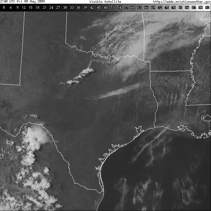
PLATEAU. VISIBLE SATELLITE IMAGERY DEPICTS CU GRADUALLY BUILDING
BETWEEN ABI AND MWL...WITH MORE VIGOROUS CU DEVELOPMENT BETWEEN OKC
AND MKO. STRONG CAPPING INVERSION REMAINS NOTED ON RECENT ACARS DATA
INVOF OKC/DAL. HOWEVER...MODIFIED FORECAST SOUNDINGS/RAOBS SUGGEST
MLCIN SHOULD BE MINIMAL ACROSS N-CNTRL TX WHERE SURFACE TEMPERATURES
HAVE REACHED 95 TO 100 DEG F WITH DEW POINTS FROM 65 TO 70 DEG F.
CONTINUED HEATING AND CONVERGENCE ASSOCIATED WITH THE SWD-SAGGING
BOUNDARY SHOULD BE SUFFICIENT FOR TSTM INITIATION AROUND 22Z. AN
EXTREMELY UNSTABLE AIRMASS AMIDST MODERATE DEEP-LAYER SHEAR WOULD
SUPPORT RAPID DEVELOPMENT OF SUPERCELLS WITH VERY LARGE HAIL.
UPSCALE GROWTH SHOULD LEAD TO CLUSTERS/QUASI-LINEAR SEGMENTS WITH
EMBEDDED SUPERCELL STRUCTURES PRODUCING LARGE HAIL/DAMAGING WINDS
AND ISOLATED TORNADOES.

..GRAMS.. 05/08/2009


ATTN...WFO...TSA...FWD...OUN...SJT...
0 likes   

Ed Mahmoud

Re: Is Extreme Weather Guy chasing tomorrow?

#16 Postby Ed Mahmoud » Fri May 08, 2009 4:37 pm

Ed Mahmoud wrote:FWIW, new NAM busts the cap at Abilene just at/before 7 pm with temps in the low 100sF (upper 30sº), then drifts a lone supercell towards Waco which poofs in the early morning hours.


Unimpressive forecast winds, but a boatload of mid-level instability.

I've got a good feel for the basic idea of evaporative cooling and downbursts, but not specifics like D-CAPE, but surface temps around 40º and dewpoints of 20º, or about 35ºF T/Td spread would seem favorable for damaging straightline winds, even if the hail and tornado threat seems small.


Image

Image


100ºF does indeed seem to be the magic temperaure for Texas storm action.
0 likes   

User avatar
srainhoutx
S2K Supporter
S2K Supporter
Posts: 6919
Age: 67
Joined: Sun Jan 14, 2007 11:34 am
Location: Haywood County, NC
Contact:

Re: Is Extreme Weather Guy chasing TODAY? MD 765 for OKC!

#17 Postby srainhoutx » Fri May 08, 2009 5:00 pm

Image
0 likes   

Ed Mahmoud

Re: Is Extreme Weather Guy chasing TODAY? MD 765 for OKC!

#18 Postby Ed Mahmoud » Fri May 08, 2009 5:11 pm

Short drive down I-35 to Texas...


Tornado Watch 272
0 likes   

User avatar
srainhoutx
S2K Supporter
S2K Supporter
Posts: 6919
Age: 67
Joined: Sun Jan 14, 2007 11:34 am
Location: Haywood County, NC
Contact:

Re: Is Extreme Weather Guy chasing TODAY? MD 765 for OKC!

#19 Postby srainhoutx » Fri May 08, 2009 5:28 pm

BULLETIN - EAS ACTIVATION REQUESTED
SEVERE THUNDERSTORM WARNING
NATIONAL WEATHER SERVICE FORT WORTH TX
518 PM CDT FRI MAY 8 2009

THE NATIONAL WEATHER SERVICE IN FORT WORTH HAS ISSUED A

* SEVERE THUNDERSTORM WARNING FOR...
SOUTHERN PALO PINTO COUNTY IN NORTH CENTRAL TEXAS...
EAST CENTRAL STEPHENS COUNTY IN NORTH CENTRAL TEXAS...

* UNTIL 615 PM CDT

* AT 517 PM CDT...NATIONAL WEATHER SERVICE METEOROLOGISTS DETECTED A
SEVERE THUNDERSTORM CAPABLE OF PRODUCING QUARTER SIZE HAIL...AND
DAMAGING WINDS IN EXCESS OF 60 MPH. THIS STORM WAS LOCATED OVER
POSSUM KINGDOM LAKE...AND MOVING SOUTHEAST AT 5 MPH.

* THE SEVERE THUNDERSTORM WILL BE NEAR...
PALO PINTO AT 540 PM
0 likes   


Return to “USA & Caribbean Weather”

Who is online

Users browsing this forum: AnnularCane and 84 guests