HAZARDOUS WEATHER OUTLOOK
NATIONAL WEATHER SERVICE HOUSTON/GALVESTON TX
653 AM CDT MON MAY 11 2009
GMZ330-335-350-355-370-375-TXZ163-164-176>179-195>200-210>214-226-
227-235>238-121200-
AUSTIN-BRAZORIA-BRAZOS-BURLESON-CHAMBERS-COLORADO-FORT BEND-
GALVESTON-GALVESTON BAY-GRIMES-HARRIS-HOUSTON-JACKSON-LIBERTY-
MADISON-MATAGORDA-MATAGORDA BAY-MONTGOMERY-POLK-SAN JACINTO-
TRINITY-WALKER-WALLER-WASHINGTON-
WATERS FROM FREEPORT TO THE MATAGORDA SHIP CHANNEL 20 NM TO 60 NM-
WATERS FROM FREEPORT TO THE MATAGORDA SHIP CHANNEL OUT 20 NM-
WATERS FROM HIGH ISLAND TO FREEPORT 20 TO 60 NM-
WATERS FROM HIGH ISLAND TO FREEPORT OUT 20 NM-WHARTON-
653 AM CDT MON MAY 11 2009
THIS HAZARDOUS WEATHER OUTLOOK IS FOR PORTIONS OF SOUTHEAST TEXAS.
.DAY ONE...TODAY AND TONIGHT
...LOCALLY HEAVY RAINFALL POSSIBLE THIS AFTERNOON...
A STATIONARY FRONT OVER NORTHEAST TEXAS AND A SURGE OF RICH GULF
MOISTURE WILL SET THE STAGE FOR THUNDERSTORMS TODAY. SCATTERED
THUNDERSTORMS WILL LIKELY DEVELOP THIS AFTERNOON OVER AREAS
GENERALLY ALONG AND NORTH OF THE INTERSTATE CORRIDOR. SOME
THUNDERSTORMS WILL LIKELY DEVELOP FROM AROUND LUFKIN TO NEAR
JASPER AND SPREAD SOUTHWEST MERGING WITH SHOWERS AND THUNDERSTORMS
OVER THE HOUSTON METROPLEX THIS AFTERNOON. HEAVY DOWNPOURS AND
STRONG GUSTY WINDS WILL ACCOMPANY THE STORMS AND STREET FLOODING
MAY OCCUR. RAINFALL ACCUMULATIONS OF AROUND ONE QUARTER INCH WILL
BE FAIRLY COMMON FOR AREA ALONG AND NORTH OF THE INTERSTATE 10
CORRIDOR...WITH ISOLATED AMOUNTS NEAR 3 INCHES POSSIBLE. SOUTH OF
THIS AREA RAINFALL AMOUNTS SHOULD BE LESS THAN ONE INCH. THE
STORMS SHOULD MOVE OFF TO THE WEST AND NORTH WEST LATE THIS
AFTERNOON AND EARLY EVENING AS THEY DISSIPATE.
.DAYS TWO THROUGH SEVEN...TUESDAY THROUGH MONDAY
ABOVE NORMAL TEMPERATURES WILL CONTINUE ACROSS THE REGION WITH
HEAT INDICIES RISING ABOVE 90 DURING THE AFTERNOON HOURS. A COLD
FRONT SHOULD MOVE THROUGH THE REGION SATURDAY NIGHT OR SUNDAY
BRINGING A ROUND OF THUNDERSTORMS TO THE AREA. OTHERWISE...NO
HAZARDOUS WEATHER IS EXPECTED AT THIS TIME.
.SPOTTER INFORMATION STATEMENT...
SPOTTER ACTIVATION MAY BE NEEDED THIS AFTERNOON.
SE TX/SW LA weather: Much cooler and WET after Tuesday
Moderator: S2k Moderators
Forum rules

The posts in this forum are NOT official forecast and should not be used as such. They are just the opinion of the poster and may or may not be backed by sound meteorological data. They are NOT endorsed by any professional institution or STORM2K.
-
srainhoutx

- S2K Supporter

- Posts: 6919
- Age: 68
- Joined: Sun Jan 14, 2007 11:34 am
- Location: Haywood County, NC
- Contact:
Re: SE TX/SW LA weather: Summer-like Pattern
Morning HWO from HGX...
0 likes
-
srainhoutx
- S2K Supporter
- Posts: 6919
- Age: 68
- Joined: Sun Jan 14, 2007 11:34 am
- Location: Haywood County, NC
- Contact:
Re: SE TX/SW LA weather: Summer-like Pattern
HGX Update...
AREA FORECAST DISCUSSION
NATIONAL WEATHER SERVICE HOUSTON/GALVESTON TX
719 AM CDT MON MAY 11 2009
.UPDATE...
UPDATE OF PACKAGE TO INCREASE POPS AND ADD MENTION OF LOCALLY
HEAVY RAINFALL.
&&
.DISCUSSION...
MODEL GUIDANCE HAS COME INTO AGREEMENT THAT SCATTERED SHRA/TSRA
WILL BE DEVELOPING TODAY ALONG THE SEABREEZE AND A BOUNDARY JUST
NORTH OF THE CWA. THE STORMS ALONG THE BOUNDARY WILL LIKELY MOVE
WEST AND SOUTHWEST EVENTUALLY MERGING WITH STORMS DEVELOPING OVER
THE CWA. IMPRESSIVE SURGE OF MOISTURE CAN BE SEEN IN THE GPS IPWV
(1.87") NOSING IN ACROSS GALVESTON BAY REGION WHERE STREAMER
SHOWERS WERE POPPING UP EARLIER. THIS AFTERNOON CAPES OF 2400-3300
J/KG /LI -4 TO -7/CINH 0/LOW HELICITIES SHOULD BE OVERALL
ENVIRONMENT THE STORMS WILL GOING UP IN. STORMS WILL BE SLOW
MOVING AND HEAVY RAINFALL A POSSIBILITY AND LOCAL 5KM WRF PUT A
COUPLE OF 2-4 INCH BULLS EYES OVER HARRIS...WALLER...MONTGOMERY...
LIBERTY...AND POLK COUNTIES. AREAS WITH MORE SUNSHINE THIS
AFTERNOON/MID 70 DEWPOINTS WILL PROMOTE GREATER INSTABILITY AND
COMBINED WITH MID LEVEL LOW THETAE AIR THAT CAN GET INTO THE ACT
WILL PRODUCE SOME GUSTY WINDS. NOT SURE ENOUGH YET TO MENTION
SEVERE BUT FOLLOWING SHIFTS WILL NEED TO MONITOR THE ACARS/AND 12Z
GUIDANCE FOR ANY INDICATIONS OF SAID CONDITIONS COMING TOGETHER.
PRECIP SHOULD COME TO AN END BEFORE 8-9 PM.
0 likes
-
Ed Mahmoud
Re: SE TX/SW LA weather: Summer-like Pattern
Lake Charles cap is almost gone with 7 am morning temps, wet paper plate cap probably not a hindrance to showers and storms in SW Louisiana (and hopefully SE Texas)

Not a huge cap at CRP either.
Weak steering could mean any storms that do form would be slow movers.
0 likes
-
srainhoutx
- S2K Supporter
- Posts: 6919
- Age: 68
- Joined: Sun Jan 14, 2007 11:34 am
- Location: Haywood County, NC
- Contact:
Re: SE TX/SW LA weather: Summer-like Pattern
Update from Jeff Lindner...
Threat for heavy rainfall this afternoon into the evening.
A combination of a southward moving outflow boundary from N TX and the seabreeze front along the coast may produce a chance of slow moving thunderstorms this afternoon across the area. Meso scale models continue to show a couple of high QPF bulls-eyes across the area where the southward moving outflow boundary and seabreeze boundary meet this afternoon. Given moisture surge off the Gulf this morning and potential for very slow storm motions of 5-10kts a few locations could see a quick 2-4 inches of rainfall. Additionally, a few storms could become severe given CAPE of 3500 by mid afternoon with temps. in the lower 90’s. Main threat appears to be wind damage and large hail .
For now will continue to watch trends and southward progression of N TX outflow boundary. Still not overly confident the cap will be broken as the sub-tropical ridge is just to our south. Best chances should be along and N of I-10.
0 likes
-
srainhoutx
- S2K Supporter
- Posts: 6919
- Age: 68
- Joined: Sun Jan 14, 2007 11:34 am
- Location: Haywood County, NC
- Contact:
Re: SE TX/SW LA weather: Summer-like Pattern
HGX Updates again re: latest sounding and model guidance...
AREA FORECAST DISCUSSION
NATIONAL WEATHER SERVICE HOUSTON/GALVESTON TX
1000 AM CDT MON MAY 11 2009
.DISCUSSION...
CHANCES FOR SCATTERED THUNDERSTORMS LOOK GOOD AFTER CHECKING THE
12Z RAOBS AND MODEL SOUNDINGS FOR TODAY. THE CRP SOUNDING WAS
UNSTABLE AND INDICATED A DCAPE OF OVER 900...A PW OF 1.4 INCHES...
AND A CAPE OF AROUND 5000. THE GFS AND NAM BUFR SOUNDINGS INDICATE
AN INVERTED V TYPE OF PROFILE AND INCREASE THE PW/S TO ABOUT 1.7
INCHES. THE LOCAL 5 KM WRF SHOWED ISOLATED THUNDERSTORMS
DEVELOPING BY MIDDAY OVER THE NORTHEASTERN SET OF COUNTIES WITH
THE OUTFLOW PUSHING SOUTHWESTWARD TO THE I-10 CORRIDOR. GIVEN THE
INSTABILITY AND PW/S...REISSUED THE HAZARDOUS WEATHER OUTLOOK TO
HIGHLIGHT THE SEVERE WEATHER POSSIBILITY IN ADDITION TO THE
LOCALLY HEAVY RAINFALL CHANCES.
HWO Update...
HAZARDOUS WEATHER OUTLOOK
NATIONAL WEATHER SERVICE HOUSTON/GALVESTON TX
941 AM CDT MON MAY 11 2009
GMZ330-335-350-355-370-375-TXZ163-164-176>179-195>200-210>214-226-
227-235>238-121200-
AUSTIN-BRAZORIA-BRAZOS-BURLESON-CHAMBERS-COLORADO-FORT BEND-
GALVESTON-GALVESTON BAY-GRIMES-HARRIS-HOUSTON-JACKSON-LIBERTY-
MADISON-MATAGORDA-MATAGORDA BAY-MONTGOMERY-POLK-SAN JACINTO-
TRINITY-WALKER-WALLER-WASHINGTON-
WATERS FROM FREEPORT TO THE MATAGORDA SHIP CHANNEL 20 NM TO 60 NM-
WATERS FROM FREEPORT TO THE MATAGORDA SHIP CHANNEL OUT 20 NM-
WATERS FROM HIGH ISLAND TO FREEPORT 20 TO 60 NM-
WATERS FROM HIGH ISLAND TO FREEPORT OUT 20 NM-WHARTON-
941 AM CDT MON MAY 11 2009
THIS HAZARDOUS WEATHER OUTLOOK IS FOR PORTIONS OF SOUTHEAST TEXAS.
...LOCALLY HEAVY RAINFALL POSSIBLE THIS AFTERNOON...
.DAY ONE...TODAY AND TONIGHT
A STATIONARY FRONT OVER NORTHEAST TEXAS AND A SURGE OF RICH GULF
MOISTURE WILL SET THE STAGE FOR THUNDERSTORMS LATER THIS
AFTERNOON. SCATTERED THUNDERSTORMS DEVELOPING FROM NEAR LUFKIN TO
JASPER ARE EXPECTED TO PUSH SOUTHWESTWARD AND MERGE WITH STORMS
DEVELOPING ALONG AND NORTH OF THE INTERSTATE 10 CORRIDOR. ISOLATED
STRONG TO SEVERE THUNDERSTORMS ARE POSSIBLE WITH HEAVY DOWNPOURS
AND STRONG GUSTY WINDS THE MAIN THREAT. STREET FLOODING MAY OCCUR.
RAINFALL ACCUMULATIONS OF AROUND ONE QUARTER INCH WILL BE FAIRLY
COMMON ALONG AND NORTH OF THE INTERSTATE 10 CORRIDOR...WITH
ISOLATED AMOUNTS NEAR 3 INCHES POSSIBLE. SOUTH OF INTERSTATE 10
RAINFALL AMOUNTS OF LESS THAN ONE INCH CAN BE EXPECTED. THE
STORMS SHOULD MOVE OFF AND DISSIPATE TO THE WEST AND NORTHWEST
LATE THIS AFTERNOON AND EARLY EVENING.
.DAYS TWO THROUGH SEVEN...TUESDAY THROUGH SUNDAY
ABOVE NORMAL TEMPERATURES WILL CONTINUE ACROSS SOUTHEAST TEXAS
WITH HEAT INDICES RISING ABOVE 90 DURING THE AFTERNOON HOURS. A
COLD FRONT SHOULD MOVE THROUGH THE REGION SATURDAY NIGHT OR SUNDAY
BRINGING A ROUND OF THUNDERSTORMS TO THE AREA. OTHERWISE...NO
HAZARDOUS WEATHER IS EXPECTED AT THIS TIME.
.SPOTTER INFORMATION STATEMENT...
SPOTTER ACTIVATION MAY BE NEEDED THIS AFTERNOON.
0 likes

-
srainhoutx
- S2K Supporter
- Posts: 6919
- Age: 68
- Joined: Sun Jan 14, 2007 11:34 am
- Location: Haywood County, NC
- Contact:
Re: SE TX/SW LA weather: Summer-like Pattern
SEVERE THUNDERSTORM WARNING
TXC201-291-339-111945-
/O.NEW.KHGX.SV.W.0092.090511T1842Z-090511T1945Z/
BULLETIN - EAS ACTIVATION REQUESTED
SEVERE THUNDERSTORM WARNING
NATIONAL WEATHER SERVICE HOUSTON/GALVESTON TX
142 PM CDT MON MAY 11 2009
THE NATIONAL WEATHER SERVICE IN LEAGUE CITY HAS ISSUED A
* SEVERE THUNDERSTORM WARNING FOR...
NORTHEASTERN HARRIS COUNTY IN SOUTHEAST TEXAS...
WESTERN LIBERTY COUNTY IN SOUTHEAST TEXAS...
SOUTHEASTERN MONTGOMERY COUNTY IN SOUTHEAST TEXAS...
* UNTIL 245 PM CDT
* AT 141 PM CDT...NATIONAL WEATHER SERVICE DOPPLER RADAR INDICATED A
SEVERE THUNDERSTORM CAPABLE OF PRODUCING PENNY SIZE HAIL...AND
DAMAGING WINDS IN EXCESS OF 60 MPH. THIS STORM WAS LOCATED NEAR
HUMBLE...AND MOVING NORTHEAST AT 10 MPH.
* LOCATIONS IN THE SEVERE THUNDERSTORM WARNING INCLUDE BUT ARE NOT
LIMITED TO WOODBRANCH... SPLENDORA...ROMAN FOREST...PATTON VILLAGE
AND KINGWOOD.
0 likes
-
PTrackerLA

- Category 5

- Posts: 5281
- Age: 42
- Joined: Thu Oct 10, 2002 8:40 pm
- Location: Lafayette, LA
Re: SE TX/SW LA weather: Summer-like Pattern
Had to run the sprinklers this weekend which means we need some rain! Once we approach 90 or higher every day, 1 week without rain allows things to dry up quickly. Models don't seem too encouraging for rain but there are storm forming to our north so maybe we'll get lucky from an outflow boundary this evening.
0 likes
-
jasons2k

- Storm2k Executive

- Posts: 8290
- Age: 52
- Joined: Wed Jul 06, 2005 12:32 pm
- Location: The Woodlands, TX
http://www.spc.noaa.gov/products/md/md0794.html
MESOSCALE DISCUSSION 0794
NWS STORM PREDICTION CENTER NORMAN OK
0105 PM CDT MON MAY 11 2009
AREAS AFFECTED...PORTIONS OF SOUTHEASTERN TX AND CENTRAL/WRN LA
CONCERNING...SEVERE POTENTIAL...WATCH UNLIKELY
VALID 111805Z - 111930Z
STORMS ARE TO EXPECTED INCREASE IN COVERAGE AND INTENSITY ACROSS
PORTIONS OF SERN TX AND WRN/CENTRAL LA THROUGH THE AFTERNOON. THOUGH
A FEW SHORT LIVED STORMS ARE POSSIBLE...WEAK ENVIRONMENTAL
WINDS/SHEAR SHOULD LIMIT A MORE WIDESPREAD THREAT.
A NEARLY STATIONARY FRONT STRETCHED FROM CENTRAL MS WWD ACROSS NRN
LA INTO ERN TX...ABOUT 40S OF TYR. FROM TYR WWD TO TPL...THE FRONT
WAS MOVING SLOWLY IN RESPONSE TO OUTFLOW BOUNDARY FROM MORNING
CONVECTION. IN THE WARM SECTOR...TEMPERATURES WARMING INTO THE
MID/UPPER 80S HAS RESULTED IN THE AIR MASS HAS BECOME STRONGLY
UNSTABLE...MLCAPE VALUES NOW UP TO 2500 J/KG. ALTHOUGH THE DEGREE OF
INSTABILITY MAY SUPPORT A FEW STRONG UPDRAFTS...WITH A POTENTIAL FOR
STRONG WIND GUSTS/MARGINALLY SEVERE HAIL...WEAK DYNAMICAL FORCING
AND 20-25 KT DEEP LAYER SHEAR SHOULD LIMIT POTENTIAL FOR LONGER
LIVED SEVERE STORMS.
0 likes
-
srainhoutx
- S2K Supporter
- Posts: 6919
- Age: 68
- Joined: Sun Jan 14, 2007 11:34 am
- Location: Haywood County, NC
- Contact:
Re: SE TX/SW LA weather: Summer-like Pattern
BULLETIN - EAS ACTIVATION REQUESTED
SEVERE THUNDERSTORM WARNING
NATIONAL WEATHER SERVICE HOUSTON/GALVESTON TX
210 PM CDT MON MAY 11 2009
THE NATIONAL WEATHER SERVICE IN LEAGUE CITY HAS ISSUED A
* SEVERE THUNDERSTORM WARNING FOR...
NORTHERN LIBERTY COUNTY IN SOUTHEAST TEXAS...
* UNTIL 300 PM CDT
* AT 210 PM CDT...NATIONAL WEATHER SERVICE DOPPLER RADAR INDICATED A
SEVERE THUNDERSTORM. THIS STORM WAS LOCATED 7 MILES SOUTH OF
TARKINGTON PRAIRIE...OR 11 MILES SOUTHEAST OF CLEVELAND...AND
MOVING EAST AT 15 MPH.
* LOCATIONS IN THE SEVERE THUNDERSTORM WARNING INCLUDE BUT ARE NOT
LIMITED TO MOSS HILL.
0 likes
-
srainhoutx
- S2K Supporter
- Posts: 6919
- Age: 68
- Joined: Sun Jan 14, 2007 11:34 am
- Location: Haywood County, NC
- Contact:
Re: SE TX/SW LA weather: Summer-like Pattern
BULLETIN - EAS ACTIVATION REQUESTED
SEVERE THUNDERSTORM WARNING
NATIONAL WEATHER SERVICE HOUSTON/GALVESTON TX
209 PM CDT MON MAY 11 2009
THE NATIONAL WEATHER SERVICE IN LEAGUE CITY HAS ISSUED A
* SEVERE THUNDERSTORM WARNING FOR...
CENTRAL AUSTIN COUNTY IN SOUTHEAST TEXAS...
SOUTHEASTERN GRIMES COUNTY IN SOUTHEAST TEXAS...
NORTHWESTERN HARRIS COUNTY IN SOUTHEAST TEXAS...
WALLER COUNTY IN SOUTHEAST TEXAS...
* UNTIL 300 PM CDT
* AT 207 PM CDT...NATIONAL WEATHER SERVICE DOPPLER RADAR INDICATED A
SEVERE THUNDERSTORM CAPABLE OF PRODUCING PENNY SIZE HAIL...AND
DAMAGING WINDS IN EXCESS OF 60 MPH. THIS STORM WAS LOCATED 7 MILES
EAST OF BELLVILLE...AND MOVING EAST AT 10 MPH.
0 likes
-
srainhoutx
- S2K Supporter
- Posts: 6919
- Age: 68
- Joined: Sun Jan 14, 2007 11:34 am
- Location: Haywood County, NC
- Contact:
Re: SE TX/SW LA weather: Summer-like Pattern
SEVERE THUNDERSTORM WATCH OUTLINE UPDATE FOR WS 288
NWS STORM PREDICTION CENTER NORMAN OK
250 PM CDT MON MAY 11 2009
SEVERE THUNDERSTORM WATCH 288 IS IN EFFECT UNTIL 800 PM CDT
FOR THE FOLLOWING LOCATIONS
TXC039-071-157-167-199-201-241-245-291-351-361-457-120100-
/O.NEW.KWNS.SV.A.0288.090511T1950Z-090512T0100Z/
TX
. TEXAS COUNTIES INCLUDED ARE
BRAZORIA CHAMBERS FORT BEND
GALVESTON HARDIN HARRIS
JASPER JEFFERSON LIBERTY
NEWTON ORANGE TYLER
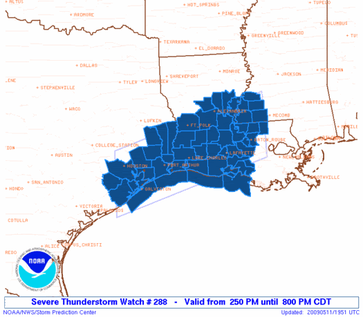
0 likes
-
vbhoutex

- Storm2k Executive
- Posts: 29149
- Age: 74
- Joined: Wed Oct 09, 2002 11:31 pm
- Location: Cypress, TX
- Contact:
Re: SE TX/SW LA weather: Summer-like Pattern
This is Jeff Lindner's comments on the situation in SE TX:
SPC has issued a Severe Thunderstorm Watch until 800pm for a large part of SE TX from Harris and Fort Bend counties eastward.
Line of severe thunderstorms is rapidly developing from near Humble to Columbus along and ahead of an outflow boundary from old thunderstorms over N TX. Within the last hour these storms have been becoming stronger with better instability now available after several hours of surface heating. ACARS out of IAH and HOU indicate an inverted V sounding profile suggesting a good threat of wind damage.
Expect storms to continue to grow and congeal into the late afternoon hours.
Additionally storm motion is extremely slow with forward motions of 8mph or less this afternoon. Cells over N Waller County have put down 1.5-2.5 inches in less than 1-hour. Will need to keep a close watch on storm motions and clustering to make sure we do not get into yet another flooding situation.
0 likes
-
srainhoutx
- S2K Supporter
- Posts: 6919
- Age: 68
- Joined: Sun Jan 14, 2007 11:34 am
- Location: Haywood County, NC
- Contact:

-
PTrackerLA
- Category 5
- Posts: 5281
- Age: 42
- Joined: Thu Oct 10, 2002 8:40 pm
- Location: Lafayette, LA
Re: SE TX/SW LA weather: Summer-like Pattern
I guess my post earlier worked, it's STORMING outside right now! Very heavy rain and lightning with some strong wind gusts occurring right now. Looks like the outflow boundary from the storms to my north moved into the area and a new cell blew up right over the city. Doesn't seem too severe, just a good ole' fashioned summer-time gully washer.
0 likes
-
southerngale

- Retired Staff

- Posts: 27418
- Joined: Thu Oct 10, 2002 1:27 am
- Location: Southeast Texas (Beaumont area)
It got a little dark and I heard thunder, and I was afraid our ballgame might rain out again (it was a make-up game from the deluge a week ago when the ballpark flooded), but thank goodness... the rain steered clear of here.
Finally... after many consecutive weeks, that dern Flood Warning is off my NWS page! Every time Pine Island Bayou would get close to falling below flood stage, we'd get a bunch more rain. We have a lot of ballgames this week... hopefully any more rain will hold off for a bit, then it can rain all it wants. Well, don't take that literally, Mother Nature!
Finally... after many consecutive weeks, that dern Flood Warning is off my NWS page! Every time Pine Island Bayou would get close to falling below flood stage, we'd get a bunch more rain. We have a lot of ballgames this week... hopefully any more rain will hold off for a bit, then it can rain all it wants. Well, don't take that literally, Mother Nature!
0 likes
-
Ed Mahmoud
Re: SE TX/SW LA weather: Summer-like Pattern
Lake Charles sounding shows very weak cap, easily gone at full daytime heating. As NWS HGX suggests, the front is retreating away, so less focus for development. 6 mph winds at IAH seem light enough the sea breeze may serve as a focus.

CRP also has a negligible cap, and even the DRT cap is breakable, with a calculated temperature of 94ºF,
CRP also has a negligible cap, and even the DRT cap is breakable, with a calculated temperature of 94ºF,
0 likes
Return to “USA & Caribbean Weather”
Who is online
Users browsing this forum: AnnularCane, HockeyTx82, Stratton23, wxman22 and 36 guests