
18Z NAM delivers one heck of a rain for southern florida as it develops low pressure South of Cuba and heads it North into southern Florida. These next few days are going to be very very very interesting. Lets see what the 18z GFS says, slatted to begin rolling out in the next 10 minutes
H-84+
http://www.nco.ncep.noaa.gov/pmb/nwprod ... p_084l.gif
Models Develop a Disturbance Near Florida (Is invest 90L)
Moderator: S2k Moderators
Forum rules

The posts in this forum are NOT official forecasts and should not be used as such. They are just the opinion of the poster and may or may not be backed by sound meteorological data. They are NOT endorsed by any professional institution or STORM2K. For official information, please refer to products from the National Hurricane Center and National Weather Service.
18Z GFS rolling in and in fact closes off a low by tomorrow night south of Cuba.
H+36
http://www.nco.ncep.noaa.gov/pmb/nwprod ... n_036l.gif
H+36
http://www.nco.ncep.noaa.gov/pmb/nwprod ... n_036l.gif
0 likes
-
Aric Dunn
- Category 5

- Posts: 21238
- Age: 43
- Joined: Sun Sep 19, 2004 9:58 pm
- Location: Ready for the Chase.
- Contact:
18z GFS clearly brings the system out of the carrib .. right about where that convection is begining to develop south of cuba or west of jamaica
http://www.nco.ncep.noaa.gov/pmb/nwprod ... odel_m.sht
will see what happens
http://www.nco.ncep.noaa.gov/pmb/nwprod ... odel_m.sht
will see what happens
0 likes
-
Aric Dunn
- Category 5
- Posts: 21238
- Age: 43
- Joined: Sun Sep 19, 2004 9:58 pm
- Location: Ready for the Chase.
- Contact:
Re: Models Develop a Disturbance in the GOM Late Next Week
Check out the 250mb level ..
the upper low begins to weaken and give way to a bit of a ridge over the system as it makes landfall in SE florida..
78 hours


the upper low begins to weaken and give way to a bit of a ridge over the system as it makes landfall in SE florida..
78 hours
0 likes
Re: Models Develop a Disturbance in the GOM Late Next Week
NWS Miami has increased the forecast winds, esp. on tuesday:
Tuesday: A 40 percent chance of showers and thunderstorms. Mostly cloudy, with a high near 83. Windy, with a east wind between 21 and 26 mph, with gusts as high as 34 mph.
http://forecast.weather.gov/MapClick.ph ... it=0&lg=en
Tuesday: A 40 percent chance of showers and thunderstorms. Mostly cloudy, with a high near 83. Windy, with a east wind between 21 and 26 mph, with gusts as high as 34 mph.
http://forecast.weather.gov/MapClick.ph ... it=0&lg=en
0 likes
-
cycloneye

- Admin

- Posts: 149514
- Age: 69
- Joined: Thu Oct 10, 2002 10:54 am
- Location: San Juan, Puerto Rico
Re: Models Develop a Disturbance in the GOM Late Next Week
18z GFS tracks it northward from Cuba but after reaching South Florida it turns left into the GOM as high pressure builds to the north.
http://www.nco.ncep.noaa.gov/pmb/nwprod ... loop.shtml
http://www.nco.ncep.noaa.gov/pmb/nwprod ... loop.shtml
0 likes

Re: Models Develop a Disturbance in the GOM Late Next Week
The first 72-hours from the 18Z GFS shows the GFS shifting the low development a bit east and deepening the system quicker. From the present satellite imagery, I'd not buy into the more aggressive models - especially considering the GFS tendency to amp low pressure systems prematurely and the CMC's trend towards conjuring big-storms (from what I saw in '07 and '08). This said, with the full blend of the guidance coupled with how vigorous spin is poised to be in the mid/upper levels over the Eastern Gulf of Mexico by late Tuesday, cyclogenesis seems a given, to me. The outlying questions are: 1) tropical cyclogenesis or non-tropical?, 2) where, 3) when?, and 4) how strong.
From the guidance I've seen, it seems likely that any surface circulation that kicks-up will be warm core and hence tropical. Given the decaying frontal boundary to be over North/Central Florida by Monday PM, though, and given the cut-off low aloft, any surface feature that spins-up may well have some non-tropical characteristics about it. A baroclinic zone seems probable off Northeast Florida, and this could contribute to an elongated trough region extending from some surface feature to develop over the Southeast Gulf of Mexico early next week. I suspect the models are having a rough go at sifting between cyclogenesis favored by the cut-off low to be over the Eastern Gulf and the baroclinic zone to form offshore East Florida. The result seems to be the models skipping between multiple lows that are kicked-up on either side of the Florida Peninsula. Intuitively, the models' limited ability to latch squarely onto one low formation or another (in several cases the models are spitting out two lows!), suggests that any strong surface low development there indicated is spurious. However, forecast models aren't usually too good at sorting out tropical (or subtropical) cyclone formation. This said, I'd not count on a particularly vigorous system just yet. Instead, the most likely scenario - to me - seems to be that the frontal boundary combined with upper level support generates a modest low pressure center over the Southeast Gulf of Mexico or near far South Florida early next week.
The effect of this system will be similar regardless of any tropical formation. There will be a significant increase in precipitation coverage across the Southern 2/3rds of the Florida Peninsula Monday through Wednesday. Breezy to windy conditions will develop along the Florida East Coast as a tight pressure gradient takes form; look for sustained winds to creep up to 15 to 20 mph with gusts 25 to 30 for coastal regions, except slightly higher along the immediate coastline/barrier islands. General rainfall totals of 1 to 3 inches Peninsula-wide for the Monday through Wednesday period seem probable with locally higher amounts. The decaying frontal boundary to eventually end up somewhere within about 50-miles of the I-4 corridor looks to be a potential precipitation focus as it offers enhanced convergence.
- Jay
0 likes
-
Aric Dunn
- Category 5
- Posts: 21238
- Age: 43
- Joined: Sun Sep 19, 2004 9:58 pm
- Location: Ready for the Chase.
- Contact:
Re: Models Develop a Disturbance in the GOM Late Next Week
cycloneye wrote:18z GFS tracks it northward from Cuba but after reaching South Florida it turns left into the GOM as high pressure builds to the north.
http://www.nco.ncep.noaa.gov/pmb/nwprod ... n_120l.gif
actually its a secondary low that developed in the SE gulf in that run the gfs has them interacting i would disregard that low right now.. till the next run.
850 vort map showing the 2 lows

0 likes
-
Aric Dunn
- Category 5
- Posts: 21238
- Age: 43
- Joined: Sun Sep 19, 2004 9:58 pm
- Location: Ready for the Chase.
- Contact:
Re: Models Develop a Disturbance in the GOM Late Next Week
NEXRAD wrote:The first 72-hours from the 18Z GFS shows the GFS shifting the low development a bit east and deepening the system quicker. From the present satellite imagery, I'd not buy into the more aggressive models - especially considering the GFS tendency to amp low pressure systems prematurely and the CMC's trend towards conjuring big-storms (from what I saw in '07 and '08). This said, with the full blend of the guidance coupled with how vigorous spin is poised to be in the mid/upper levels over the Eastern Gulf of Mexico by late Tuesday, cyclogenesis seems a given, to me. The outlying questions are: 1) tropical cyclogenesis or non-tropical?, 2) where, 3) when?, and 4) how strong.
From the guidance I've seen, it seems likely that any surface circulation that kicks-up will be warm core and hence tropical. Given the decaying frontal boundary to be over North/Central Florida by Monday PM, though, and given the cut-off low aloft, any surface feature that spins-up may well have some non-tropical characteristics about it. A baroclinic zone seems probable off Northeast Florida, and this could contribute to an elongated trough region extending from some surface feature to develop over the Southeast Gulf of Mexico early next week. I suspect the models are having a rough go at sifting between cyclogenesis favored by the cut-off low to be over the Eastern Gulf and the baroclinic zone to form offshore East Florida. The result seems to be the models skipping between multiple lows that are kicked-up on either side of the Florida Peninsula. Intuitively, the models' limited ability to latch squarely onto one low formation or another (in several cases the models are spitting out two lows!), suggests that any strong surface low development there indicated is spurious. However, forecast models aren't usually too good at sorting out tropical (or subtropical) cyclone formation. This said, I'd not count on a particularly vigorous system just yet. Instead, the most likely scenario - to me - seems to be that the frontal boundary combined with upper level support generates a modest low pressure center over the Southeast Gulf of Mexico or near far South Florida early next week.
The effect of this system will be similar regardless of any tropical formation. There will be a significant increase in precipitation coverage across the Southern 2/3rds of the Florida Peninsula Monday through Wednesday. Breezy to windy conditions will develop along the Florida East Coast as a tight pressure gradient takes form; look for sustained winds to creep up to 15 to 20 mph with gusts 25 to 30 for coastal regions, except slightly higher along the immediate coastline/barrier islands. General rainfall totals of 1 to 3 inches Peninsula-wide for the Monday through Wednesday period seem probable with locally higher amounts. The decaying frontal boundary to eventually end up somewhere within about 50-miles of the I-4 corridor looks to be a potential precipitation focus as it offers enhanced convergence.
- Jay
good analysis .. it still remains to be seen where the surface low will take shape. I would shoot for areas of more concentrated convection and right now( which is a little premature but has the most convergence and may shift ) is just south of cuba .. where this to happen a more tropical system would likely be line..
its going to tricky over the next 24 to 36 hrs to make any heads or tails out of the models since there is nothing there yet to initialize.
once we see that upper low begin to take shape and the low to midlevel trough the models are just not going to be very helpful beyond general motion of the system ..
0 likes
-
Aric Dunn
- Category 5
- Posts: 21238
- Age: 43
- Joined: Sun Sep 19, 2004 9:58 pm
- Location: Ready for the Chase.
- Contact:
well here is a much better look at the 12z euro ...showing same development area as GFS and NAM
also showing a very large area to it..
http://www.meteo.psu.edu/~gadomski/ECMW ... floop.html
also showing a very large area to it..
http://www.meteo.psu.edu/~gadomski/ECMW ... floop.html
0 likes


-
jlauderdal
- S2K Supporter

- Posts: 7240
- Joined: Wed May 19, 2004 5:46 am
- Location: NE Fort Lauderdale
- Contact:
Re: Models Develop a Disturbance in the GOM Late Next Week
I am taking this opportunity to be the first person on this board to call for a recon flight. 
0 likes
-
MGC

- S2K Supporter
- Posts: 5940
- Joined: Sun Mar 23, 2003 9:05 pm
- Location: Pass Christian MS, or what is left.
Re: Models Develop a Disturbance in the GOM Late Next Week
I was over in Slidell today at NWS New Orleans open house. While everyone was out watching the balloon launch (I skipped it since I've witnessed many while in the Navy), I talked with the forecaster on duty about the GOM low. He was not that concerned and said it might become tropical but remain weak. He expected it to start out as baroclinic but perhaps transition to tropical. He showed me the GFS and it had the low coming ashore near Mobile....MGC
0 likes


-
Rainband
Re: Models Develop a Disturbance in the GOM Late Next Week
looks like it's going to be a wet week 
0 likes
Re: Models Develop a Disturbance in the GOM Late Next Week
Nexrad/Jay i would up the winds a tad from 15-20 gust to 30 on beach (cause that is pretty much the case right now) and i would think the gradient would be stronger in S. FL tues/wed.........
I live across the ocean in boca and i would think that the pressure difference from the high and what ever low forms will get gusts up to 35-40 ....again no big deal....unless you are in THE OCEAN...
I live across the ocean in boca and i would think that the pressure difference from the high and what ever low forms will get gusts up to 35-40 ....again no big deal....unless you are in THE OCEAN...
0 likes
-
cycloneye
- Admin
- Posts: 149514
- Age: 69
- Joined: Thu Oct 10, 2002 10:54 am
- Location: San Juan, Puerto Rico
Re: Models Develop a Disturbance in the GOM Late Next Week
Atlantic Tropical Weather Discussion
--------------------------------------------------------------------------------
000
AXNT20 KNHC 162348
TWDAT
TROPICAL WEATHER DISCUSSION
NWS TPC/NATIONAL HURRICANE CENTER MIAMI FL
805 PM EDT SAT MAY 16 2009
TROPICAL WEATHER DISCUSSION FOR NORTH AMERICA...CENTRAL
AMERICA...GULF OF MEXICO...CARIBBEAN SEA...NORTHERN SECTIONS
OF SOUTH AMERICA...AND ATLANTIC OCEAN TO THE AFRICAN COAST
FROM THE EQUATOR TO 32N. THE FOLLOWING INFORMATION IS BASED
ON SATELLITE IMAGERY...METEOROLOGICAL ANALYSIS...WEATHER
OBSERVATIONS...AND RADAR.
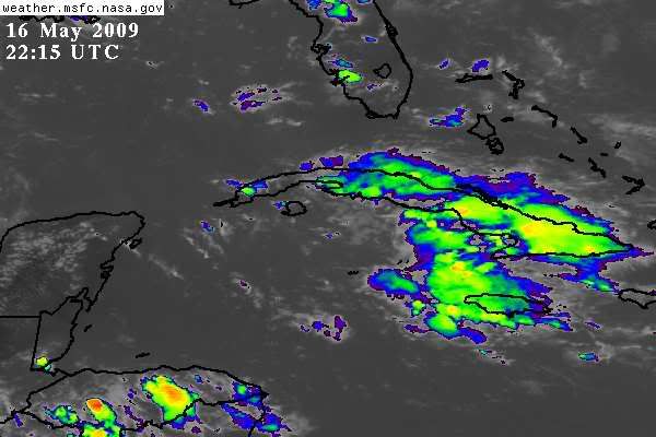
BASED ON 1800 UTC SURFACE ANALYSIS AND SATELLITE IMAGERY
THROUGH 2315 UTC.
...THE ITCZ...
THE ITCZ AXIS IS CENTERED ALONG 6N10W 3N15W 1N20W CROSSING THE
EQUATOR NEAR 23W TO NE BRAZIL NEAR 3S39W. SCATTERED MODERATE
CONVECTION IS WITHIN 30 NM OF THE AXIS BETWEEN 17W-20W.
...DISCUSSION...
THE GULF OF MEXICO...
MUCH OF THE GULF WATERS IS EXPERIENCING QUITE CONDITIONS...BUT
IT IS QUITE DIFFERENT JUST INLAND ALONG THE N GULF COAST. A COLD
FRONT OVER THE SE CONUS COMBINED WITH A DIFFLUENT PATTERN ALOFT
IS SUPPORTING WIDESPREAD SCATTERED SHOWERS AND TSTMS THERE. SOME
OF THIS UNSETTLED WEATHER IS BEGINNING TO MOVE INTO THE FAR NW
WATERS FROM 25N-27N W OF 96W JUST AHEAD OF THE FRONT. THIS FRONT
IS FORECAST TO MOVE OFFSHORE INTO THE NW GULF LATE TONIGHT THEN
TRACK SE AND WEAKEN SUN AND MON. BY MON...MANY OF THE GLOBAL
MODELS ARE SHOWING LOW PRES DEVELOP OVER CUBA OR THE SE
GULF...EITHER EXTRATROPICAL OR SUBTROPICAL...AND MOVING
GENERALLY N. ITS DEVELOPMENT AND TRACK IS UNCERTAIN BUT MODELS
ARE IN ENOUGH AGREEMENT TO WARRANT GALE HEADLINES OVER A PORTION
OF THE E AND MIDDLE WATERS FOR EARLY NEXT WEEK.
THE CARIBBEAN SEA...
A MID TO UPPER TROUGH OVER THE WRN CARIBBEAN IS PRODUCING
SCATTERED SHOWERS AND TSTMS N OF 17N BETWEEN 75W-84W. LIGHTNING
DATA SHOWS THE GREATEST CONCENTRATION OF STRIKES OVER CUBA...AS
LOCAL SEABREEZE/TERRAIN EFFECTS ARE PROVIDING ENHANCED LIFT.
LATEST VIS/SHORTWAVE IR IMAGES SHOW CYCLONIC ROTATION IN THE MID
LEVEL CLOUDS ALONG 79W JUST S OF CUBA. THIS FEATURE MAY BUILD
CLOSER TO THE SFC OVER THE NEXT COUPLE OF DAYS AND DRIFT
GENERALLY NWD...
http://www.storm2k.org/weather/hw3.php? ... hwvmetric=
0 likes
-
cycloneye
- Admin
- Posts: 149514
- Age: 69
- Joined: Thu Oct 10, 2002 10:54 am
- Location: San Juan, Puerto Rico
Re: Models Develop a Disturbance in the GOM Late Next Week
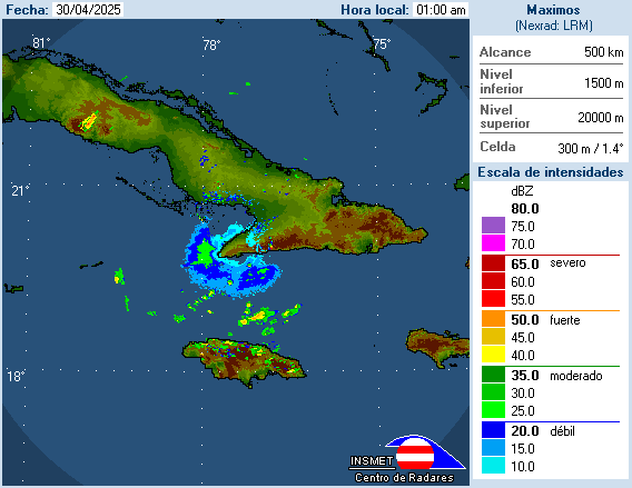
A weak twist in the clouds can be seen in this Cuban radar located at Pilon.
0 likes
-
Tampa Bay Hurricane

- Category 5
- Posts: 5597
- Age: 38
- Joined: Fri Jul 22, 2005 7:54 pm
- Location: St. Petersburg, FL
http://www.ssd.noaa.gov/goes/east/gmex/loop-rb.html
Mid Level Rotation visible near 79-81 W just south of Cuba...
As pointed out by the TWD....
Tropical Storm Force wind gusts *(not necessarily a
tropical system; it may be sub/extra tropical...but the impacts will
be 40+ mph gusts with gradient and strong squalls/storms) are looking to be pretty
likely witn the pressure gradient over S FL the next 3 days.
0 likes
Who is online
Users browsing this forum: tolakram and 124 guests