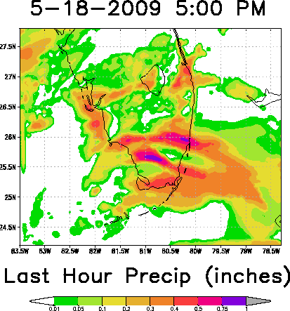
Models Develop a Disturbance Near Florida (Is invest 90L)

This is the general tropical discussion area. Anyone can take their shot at predicting a storms path.

Moderator: S2k Moderators

Forum rules

The posts in this forum are NOT official forecasts and should not be used as such. They are just the opinion of the poster and may or may not be backed by sound meteorological data. They are NOT endorsed by any professional institution or STORM2K. For official information, please refer to products from the National Hurricane Center and National Weather Service.

Help Support Storm2K
Message
Author
JonathanBelles
Professional-Met
Professional-Met
Posts: 11430
Age: 35
Joined: Sat Dec 24, 2005 9:00 pm
Location: School: Florida State University (Tallahassee, FL) Home: St. Petersburg, Florida
Contact:

Re: Models Develop a Disturbance in the GOM Late This Week

#421 Postby JonathanBelles » Sun May 17, 2009 7:57 pm

boca wrote:
TampaFl wrote:here is the radar out of Gitmo, Cuba courtesy NWS Key West. There is a spin noted although there is not alot of precipitation. Thoughts & comments welcomed:

Robert 8-)

http://radar.weather.gov/ridge/radar_lite.php?rid=gmo&product=N0R&loop=yes


Its amazing how primative that radar is compared to ours.It does the job though.


Here is another one from Cuba.

http://www.insmet.cu/asp/genesis.asp?TB ... axw01a.gif
0 likes   

User avatar
boca
Category 5
Category 5
Posts: 6368
Age: 60
Joined: Mon Dec 15, 2003 8:49 am
Location: Boca Raton,FL

Re: Models Develop a Disturbance in the GOM Late This Week

#422 Postby boca » Sun May 17, 2009 7:59 pm

It looks like the mid level low is between Jamiaca and the southern coast of Cuba on this sat. This could be in the SE Bahamas by Mon morning.

http://metofis.rsmas.miami.edu/~dortt/s ... 1_loop.gif
0 likes   

User avatar
cycloneye
Admin
Admin
Posts: 145640
Age: 68
Joined: Thu Oct 10, 2002 10:54 am
Location: San Juan, Puerto Rico

Re: Models Develop a Disturbance in the GOM Late This Week

#423 Postby cycloneye » Sun May 17, 2009 8:14 pm

Guantanamo Radar

Some rotation is evident.

http://radar.weather.gov/ridge/radar_li ... R&loop=yes
0 likes   

nashrobertsx
Tropical Depression
Tropical Depression
Posts: 85
Joined: Fri Aug 15, 2008 3:55 pm

#424 Postby nashrobertsx » Sun May 17, 2009 8:25 pm

I guess the guys that run this thing are aware of this, but it is very difficult to find this page on the GOM Low. I know this is the first of the season, but if you go to TALKING TROPICS.. then ACTIVE STORMS... you see all these adminstrative type posts and you can't find the STORM page. Is it me or what? The only way I found it was to post something, and then it was merged into the existing TOPIC, and I hit VIEW POST and it got me to what I was looking for, for over an hour. I made a new Topic because I couldn't find this one, and it was merged into this one. Tell me if it is me or is something not right and being worked on. Moderator?
0 likes   

cpdaman
Category 5
Category 5
Posts: 3131
Joined: Sat Jun 10, 2006 11:44 am
Location: SPB county (gulf stream)

Re: Models Develop a Disturbance in the GOM Late This Week

#425 Postby cpdaman » Sun May 17, 2009 8:28 pm

how many pages do you think we can go for this "entity" by thursday nite

i say we get 110 ............
0 likes   

User avatar
gatorcane
S2K Supporter
S2K Supporter
Posts: 23692
Age: 47
Joined: Sun Mar 13, 2005 3:54 pm
Location: Boca Raton, FL

Re:

#426 Postby gatorcane » Sun May 17, 2009 8:32 pm

nashrobertsx wrote:I guess the guys that run this thing are aware of this, but it is very difficult to find this page on the GOM Low. I know this is the first of the season, but if you go to TALKING TROPICS.. then ACTIVE STORMS... you see all these adminstrative type posts and you can't find the STORM page. Is it me or what? The only way I found it was to post something, and then it was merged into the existing TOPIC, and I hit VIEW POST and it got me to what I was looking for, for over an hour. I made a new Topic because I couldn't find this one, and it was merged into this one. Tell me if it is me or is something not right and being worked on. Moderator?


It will go into active storms if there is an invest tagged.
Last edited by gatorcane on Sun May 17, 2009 8:32 pm, edited 1 time in total.
0 likes   

User avatar
cycloneye
Admin
Admin
Posts: 145640
Age: 68
Joined: Thu Oct 10, 2002 10:54 am
Location: San Juan, Puerto Rico

Re: Models Develop a Disturbance in the GOM Late This Week

#427 Postby cycloneye » Sun May 17, 2009 8:32 pm

cpdaman wrote:how many pages do you think we can go for this "entity" by thursday nite

i say we get 110 ............


Until a invest is up for this if it occurs,then the thread will be closed and a new invest thread will be made at Active Storms forum.In the meantime,this thread will go ahead regardless of how many pages it has.
0 likes   

User avatar
WeatherLovingDoc
S2K Supporter
S2K Supporter
Posts: 453
Joined: Fri Sep 05, 2008 10:08 pm
Location: Washington D.C.

Re: Models Develop a Disturbance in the GOM Late This Week

#428 Postby WeatherLovingDoc » Sun May 17, 2009 8:35 pm

cpdaman wrote:how many pages do you think we can go for this "entity" by thursday nite

i say we get 110 ............

entity: that which is perceived or known or inferred to have its own distinct existence (living or nonliving) :double:
0 likes   

User avatar
gatorcane
S2K Supporter
S2K Supporter
Posts: 23692
Age: 47
Joined: Sun Mar 13, 2005 3:54 pm
Location: Boca Raton, FL

#429 Postby gatorcane » Sun May 17, 2009 8:38 pm

For those that want to closely watch when an INVEST is tagged, use this page:

http://www.nrlmry.navy.mil/tc_pages/tc_home.html

Right now it shows no active storms.

A couple of observations on this area:

1) The convection envelope continues to decline this evening
2) But, water Vapor loop shows very little dry air around this area.
3) Its probably going to spend some time over Cuba tomorrow, which will prevent any kind or organization at the surface until it can get back over water.
4) Mean direction vector appears around NNW, on track with GFS and UKMET (something tells me its going to pass right of Florida...and not as much rain as we are anticipating, hope I am wrong and it swings back west bringing plenty of rain....)
Last edited by gatorcane on Sun May 17, 2009 8:46 pm, edited 6 times in total.
0 likes   

Rainband

Re: Models Develop a Disturbance in the GOM Late This Week

#430 Postby Rainband » Sun May 17, 2009 8:38 pm

cycloneye wrote:Guantanamo Radar

Some rotation is evident.

http://radar.weather.gov/ridge/radar_li ... R&loop=yes
yep that's what i see
0 likes   

Rainband

Re:

#431 Postby Rainband » Sun May 17, 2009 8:49 pm

gatorcane wrote:For those that want to closely watch when an INVEST is tagged, use this page:

http://www.nrlmry.navy.mil/tc_pages/tc_home.html

Right now it shows no active storms.

A couple of observations on this area:

1) The convection envelope continues to decline this evening
2) But, water Vapor loop shows very little dry air around this area.
3) Its probably going to spend some time over Cuba tomorrow, which will prevent any kind or organization at the surface until it can get back over water.
4) Mean direction vector appears around NNW, on track with GFS and UKMET (something tells me its going to pass right of Florida...and not as much rain as we are anticipating, hope I am wrong and it swings back west bringing plenty of rain....)
I think it's called a diurnal min. lol I think the convection will flare up again but it looks like something may pop in the bahamas instead of the gom but again. I am a novice :P
0 likes   

User avatar
gatorcane
S2K Supporter
S2K Supporter
Posts: 23692
Age: 47
Joined: Sun Mar 13, 2005 3:54 pm
Location: Boca Raton, FL

#432 Postby gatorcane » Sun May 17, 2009 8:51 pm

:uarrow:

I hope it is over Florida during the diurnal maximum :P -- we really need the rain bad and this is a golden opportunity, but is it too good to be true? As long as it passes over Florida or just west -- we will get a nice soaking otherwise, it could be a let down.

I am truly thinking positive.
Last edited by gatorcane on Sun May 17, 2009 8:54 pm, edited 1 time in total.
0 likes   

Rainband

Re: Models Develop a Disturbance in the GOM Late This Week

#433 Postby Rainband » Sun May 17, 2009 8:52 pm

time will tell :P I say about 2am we may see some convection again.
0 likes   

Bailey1777
S2K Supporter
S2K Supporter
Posts: 962
Joined: Mon Jul 31, 2006 6:23 pm
Location: Houston, Texas

#434 Postby Bailey1777 » Sun May 17, 2009 8:54 pm

I thought the train of thought here was not to focus on that junk already south of Cuba but on the trough digging down into the GOM right now and that whatever surface feature we may get would pinch off from that .
0 likes   

User avatar
boca
Category 5
Category 5
Posts: 6368
Age: 60
Joined: Mon Dec 15, 2003 8:49 am
Location: Boca Raton,FL

Re:

#435 Postby boca » Sun May 17, 2009 9:02 pm

Bailey1777 wrote:I thought the train of thought here was not to focus on that junk already south of Cuba but on the trough digging down into the GOM right now and that whatever surface feature we may get would pinch off from that .


I feel you are correct as long as the system down by Cuba doesn't get its act together.
0 likes   

Aric Dunn
Category 5
Category 5
Posts: 21238
Age: 42
Joined: Sun Sep 19, 2004 9:58 pm
Location: Ready for the Chase.
Contact:

Re: Models Develop a Disturbance in the GOM Late This Week

#436 Postby Aric Dunn » Sun May 17, 2009 9:08 pm

that area is just a small part of what may take shape not to be disregarded just not entirely focused on... :darrow: :darrow:

Bailey1777 wrote:I thought the train of thought here was not to focus on that junk already south of Cuba but on the trough digging down into the GOM right now and that whatever surface feature we may get would pinch off from that .


Aric Dunn wrote:Though i would put it in perspective for everyone real fast this is the area we have to watch give or take a couple hundred miles on any direction!!!! lol hehehe :double: :ggreen: :cheesy: :lol: :eek: :) :D

Image
0 likes   

Aric Dunn
Category 5
Category 5
Posts: 21238
Age: 42
Joined: Sun Sep 19, 2004 9:58 pm
Location: Ready for the Chase.
Contact:

#437 Postby Aric Dunn » Sun May 17, 2009 9:13 pm

00z NAM coming in....
http://www.nco.ncep.noaa.gov/pmb/nwprod ... loop.shtml

just a note the 00z run of all the models will be very important as few things are beginning to come together i.e the frontal boundary is finally pushing into the central gulf and a lot of moisture is streaming northward among other things.. but the data this evening is quite a bit different than this morning and afternoon ..

the NAM already looks a little more stable not so many lows all over the place.. given its the NAM of course will see.
0 likes   

User avatar
MGC
S2K Supporter
S2K Supporter
Posts: 5900
Joined: Sun Mar 23, 2003 9:05 pm
Location: Pass Christian MS, or what is left.

Re: Models Develop a Disturbance in the GOM Late This Week

#438 Postby MGC » Sun May 17, 2009 9:14 pm

I vote for the low to form east of Florida in the Bahamas by Tuesday noon. This is a pretty strong high for this time of the year and should turn the low towards the west. Low should cross the coast around the Cape. Does not look like S Fla will not get much rain. Only a 25% chance that the system gets named. Should stay weak. If I'm wrong and the system developes west or over the Fla pen then the system has a better chance of being named out over the GOM....MGC
0 likes   

User avatar
Evil Jeremy
S2K Supporter
S2K Supporter
Posts: 5463
Age: 32
Joined: Mon Apr 10, 2006 2:10 pm
Location: Los Angeles, CA

Re: Models Develop a Disturbance in the GOM Late This Week

#439 Postby Evil Jeremy » Sun May 17, 2009 9:17 pm

Does not look like S Fla will not get much rain.


Just to clarify, is that an intended double negative lol?
0 likes   

User avatar
HURAKAN
Professional-Met
Professional-Met
Posts: 46086
Age: 38
Joined: Thu May 20, 2004 4:34 pm
Location: Key West, FL
Contact:

#440 Postby HURAKAN » Sun May 17, 2009 9:26 pm

0 likes   


Return to “Talkin' Tropics”

Who is online

Users browsing this forum: 7cardinal, duilaslol, gib, Google Adsense [Bot], Stratton23, weeniepatrol and 61 guests