Models Develop a Disturbance Near Florida (Is invest 90L)

This is the general tropical discussion area. Anyone can take their shot at predicting a storms path.

Moderator: S2k Moderators

Forum rules

The posts in this forum are NOT official forecasts and should not be used as such. They are just the opinion of the poster and may or may not be backed by sound meteorological data. They are NOT endorsed by any professional institution or STORM2K. For official information, please refer to products from the National Hurricane Center and National Weather Service.

Help Support Storm2K
Message
Author
Aric Dunn
Category 5
Category 5
Posts: 21238
Age: 42
Joined: Sun Sep 19, 2004 9:58 pm
Location: Ready for the Chase.
Contact:

Re: Models Develop a Disturbance in the GOM Late This Week

#501 Postby Aric Dunn » Mon May 18, 2009 5:38 am

There are a few interesting points this morning in regards to the overall development of the system. there are 2 areas to watch, first the area in the SE gulf and florida straights.
this morning the diving frontal boundary (in blue) is beginning to absorb a sharp trough that was in place in the central and eastern gulf yesterday and last night. This trough is helping to focus much of the developing convection this morning in the eastern and se gulf with some typical frontal type convection approaching the Florida west coast. Watch for the convection to spread SE and increase in coverage and become more concentrated around a low that should begin to develop later today near the where the sharp trough ( white dashed line ) and the front with the NE flow behind it and SE flow ahead of it come together. that whole area will move SE and deepen throughout the day and night. This area will likely a frontal type low to start but may transition rather fast. there is still some cool air advection in the low to mid-levels but this air mass is moderating as it moves south so and transition to sub-tropical is possible.

the area circled will be the area to watch and a secondary low will likely form SE of S florida but most of the dynamics are going to be associated with the low that should form in the SE gulf. now how far the area circled moves SE or how far the low for that matter would continue to move SE before slowing as the fronta washes out and high pressure build back in is a little more tricky and am not going to speculate as of right now.
the image below trying to show this set up this morning.. ( sorry about the crudeness)

Image
0 likes   

User avatar
ronjon
Category 5
Category 5
Posts: 4824
Joined: Fri Aug 19, 2005 5:17 pm
Location: Hernando Beach, FL

Re: Models Develop a Disturbance in the GOM Late This Week

#502 Postby ronjon » Mon May 18, 2009 5:52 am

TAFB 48 hr forecast:

Image
0 likes   

User avatar
HURAKAN
Professional-Met
Professional-Met
Posts: 46086
Age: 38
Joined: Thu May 20, 2004 4:34 pm
Location: Key West, FL
Contact:

#503 Postby HURAKAN » Mon May 18, 2009 6:00 am

:uarrow: Our two disturbances connect!?!?
0 likes   

User avatar
Tampa Bay Hurricane
Category 5
Category 5
Posts: 5597
Age: 37
Joined: Fri Jul 22, 2005 7:54 pm
Location: St. Petersburg, FL

#504 Postby Tampa Bay Hurricane » Mon May 18, 2009 6:49 am

I'm beginning to think the major low will be the one off the SW Coast
of FL/In the straits...the one east of cuba looks like just a sheared
mess...
0 likes   

User avatar
cycloneye
Admin
Admin
Posts: 145630
Age: 68
Joined: Thu Oct 10, 2002 10:54 am
Location: San Juan, Puerto Rico

Re: Models Develop a Disturbance in the GOM Late This Week

#505 Postby cycloneye » Mon May 18, 2009 6:59 am

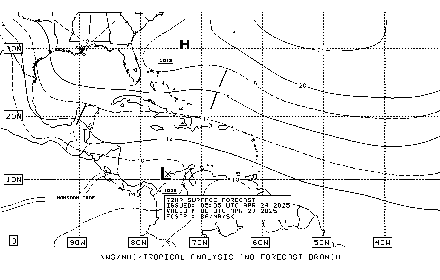
TAFB 72 hour forecast

Image
0 likes   

User avatar
BigA
Professional-Met
Professional-Met
Posts: 1317
Joined: Sun Jul 24, 2005 10:56 pm

Re: Models Develop a Disturbance in the GOM Late This Week

#506 Postby BigA » Mon May 18, 2009 7:13 am

Whoever/Whatever is in charge of creating the TAFB forecast seems to favor the western (Florida straits) solution.
0 likes   

User avatar
wxman57
Moderator-Pro Met
Moderator-Pro Met
Posts: 22984
Age: 67
Joined: Sat Jun 21, 2003 8:06 pm
Location: Houston, TX (southwest)

Re:

#507 Postby wxman57 » Mon May 18, 2009 7:38 am

Tampa Bay Hurricane wrote:I'm beginning to think the major low will be the one off the SW Coast
of FL/In the straits...the one east of cuba looks like just a sheared
mess...


What you see near eastern Cuba is what's left of the weak mid-level low that's kicking out to the NNE ahead of the approaching upper trof/front. The focus for any surface development will be farther west on the front, probably near FL Straits.
0 likes   

User avatar
artist
Category 5
Category 5
Posts: 9792
Joined: Mon Jun 06, 2005 3:26 pm
Location: West Palm

Re: Models Develop a Disturbance in the GOM Late This Week

#508 Postby artist » Mon May 18, 2009 8:11 am

Image

sflorida water management is posting the ukmet model here

Mon May 18 09:04:14 EDT 2009


935

WTNT80 EGRR 180600


MET OFFICE TROPICAL CYCLONE GUIDANCE FOR NORTH-EAST PACIFIC

AND ATLANTIC

GLOBAL MODEL DATA TIME 00UTC 18.05.2009

NEW TROPICAL STORM FORECAST TO DEVELOP AFTER 36 HOURS
FORECAST POSITION AT T+ 36 : 23.6N 78.2W

VERIFYING TIME POSITION STRENGTH TENDENCY
-------------- -------- -------- --------
12UTC 19.05.2009 23.6N 78.2W WEAK
00UTC 20.05.2009 26.5N 80.4W MODERATE INTENSIFYING RAPIDLY
12UTC 20.05.2009 27.6N 82.6W MODERATE WEAKENING RAPIDLY
00UTC 21.05.2009 27.5N 86.3W WEAK WEAKENING SLIGHTLY
12UTC 21.05.2009 26.8N 87.4W WEAK WEAKENING SLIGHTLY
00UTC 22.05.2009 27.5N 87.4W WEAK LITTLE CHANGE
12UTC 22.05.2009 27.9N 88.0W WEAK LITTLE CHANGE
00UTC 23.05.2009 28.3N 89.1W WEAK LITTLE CHANGE
12UTC 23.05.2009 29.9N 89.5W WEAK LITTLE CHANGE
00UTC 24.05.2009 31.7N 90.9W WEAK WEAKENING SLIGHTLY


THIS INFORMATION IS PROVIDED AS GUIDANCE FOR TROPICAL CYCLONE
RSMCS. IT REQUIRES INTERPRETATION BY TROPICAL CYCLONE SPECIALISTS
AND SHOULD NOT BE CONSIDERED AS A FINAL PRODUCT


MET OFFICE, EXETER, UK

TOO 180437

https://my.sfwmd.gov/portal/page?_pagei ... ema=PORTAL
Last edited by artist on Mon May 18, 2009 8:12 am, edited 1 time in total.
0 likes   

User avatar
tailgater
S2K Supporter
S2K Supporter
Posts: 3339
Joined: Sun Jul 11, 2004 9:13 pm
Location: St. Amant La.

Re: Models Develop a Disturbance in the GOM Late This Week

#509 Postby tailgater » Mon May 18, 2009 8:12 am

Ok Fla. you asked for the rain. I beleive you'll be getting it in the next couple days at least the southern half of the state. I just hope you don't get too much of a good thing.
Image

Looks like the Upper trough will be lifting out soon.
0 likes   

User avatar
ronjon
Category 5
Category 5
Posts: 4824
Joined: Fri Aug 19, 2005 5:17 pm
Location: Hernando Beach, FL

Re: Models Develop a Disturbance in the GOM Late This Week

#510 Postby ronjon » Mon May 18, 2009 8:17 am

HPC 5-day rainfall estimates.

Image
0 likes   

User avatar
cycloneye
Admin
Admin
Posts: 145630
Age: 68
Joined: Thu Oct 10, 2002 10:54 am
Location: San Juan, Puerto Rico

Re: Models Develop a Disturbance in the GOM Late This Week

#511 Postby cycloneye » Mon May 18, 2009 8:22 am

Dr Jeff Masters Latest Analisis

Florida poised for a substantial soaking


Posted by: JeffMasters, 1:03 PM GMT on May 18, 2009

An area of showers and thunderstorms is over the southeastern Bahamas and eastern Cuba, in association with a trough of low pressure. The latest 00Z and 06Z runs of the GFS, UKMET, NOGAPS, and ECMWF global dynamical computer models continue to forecast that this disturbance will develop into an extratropical low by Tuesday. The low should bring heavy rain and possible flooding problems to Florida and the Bahamas this week as it lifts northwestward over Florida. Up to nine inches of rain may fall over Florida by Friday (Figure 1), thanks also to a cold front expected to move over the state over the next two days. The exact timing and location of the rains over Florida are still uncertain, as the GFS model predicts development of the low over the Bahamas, while the ECMWF and UKMET models predict development over South Florida. At present, it appears wind shear will be too high to allow the extratropical storm to transition into a subtropical or tropical storm. However, if the storm's center emerges into the northern Gulf of Mexico late this week, wind shear may be low enough to allow a transition to a subtropical storm (10% chance).

Florida could use the rain--most of South Florida is under extreme drought, and Central Florida is under severe drought. The Lake Okeechobee water level is at 10.58 feet (Figure 2), which is about 3 feet below average. During the past week, the lake fell below the level that triggers water conservation measures for the first time since Tropical Storm Fay filled up the lake in August.
0 likes   

Derek Ortt

#512 Postby Derek Ortt » Mon May 18, 2009 8:49 am

I can see some weak low-level turning on 1KM visible to the SW of KW... though it is very very weak at this time

May be the region to watch for development, however
0 likes   

NEXRAD
Category 1
Category 1
Posts: 370
Joined: Fri Jul 22, 2005 12:05 am
Location: South Florida

Re: Models Develop a Disturbance in the GOM Late This Week

#513 Postby NEXRAD » Mon May 18, 2009 8:52 am

Good Monday morning, all.

Model guidance seems reasonable with handling the frontal boundary and future potential surface low. The exception is the GFS, which continues to be a substantial outlier. The 06Z GFS, especially, looks to have inconsistencies with other guidance in that this run of the GFS develops two surface lows on either side of Andros Island by Tuesday PM (36VT). The model then meanders both lows around the near-Florida region through late week while washing out the precipitation over Florida, when compared with the NAM, for example. I suspect that the GFS solution can be disregarded as it does not handle the surface low development too well and it seems to downplay the QPFs too much in vicinity of the frontal boundary across Florida. This boundary will provide a distinct convergence area for convective development and may well allow a cell training situation to unfold Monday PM through at least Tuesday PM for some part of the Peninsula.

I'd recommend going with the NAM/UKMET/ECMWF blend. Look for the initial surface low to kick-up sometime between tonight and midday Tuesday within a region extending from Naples, Florida, to Havana, Cuba, to Andros Island. This region of prospective surface circulation development coincides well with CIMSS vorticity trends during the past 12 hours, which are showing increased H70 vorticity across the Gulf of Mexico and the tongue of vorticity extending from SE Cuba to west of Andros Island as of 12Z. Low level easterlies will force this low on a west-northwest track should it develop farther east. This is distinct from the GFS scenario, which seems to embed the surface system it generates in the mid-level steering flow. Such steering would apply less to a weaker surface low, which is what we'll likely have out of this system for the Monday PM - Tuesday time frame.

Convectively, PW's are quite high across the entire Florida Peninsula and into SE Georgia per the 13Z SPC mesoanalysis. Many locations are well above 1.5". Precipitable water values will only increase over the next 24 hours as further moisture streams in from the Caribbean. The frontal boundary is certainly cropping up widespread convection in this moist environment, with numerous convective clusters ongoing across Nrn/Central Florida and across the Ern Gulf of Mexico. This front's movement over the next day or two will provide insight into where the heaviest rainfall will take shape across Florida. NWS Melbourne and the HPC project the front to stall out across Central Florida whereas the 12Z RUC/2 and NWS Miami suggest that the front will move into South Florida. Since no surface low has formed yet across the Bahamas/Florida Straits, I'd expect a slightly more south approach with the front than the HPC projection. Once the surface low develops and moves over/near South Florida, it should merge with the remnant boundary. The boundary will thereafter lift slowly northward as a sort of warm front. In addition to the frontal boundary providing a convective focus, I also anticipate locally enhanced convergence along the Florida East Coast to provide enhanced rainfall rates. Finally, any larger-scale boundaries (such as an outflow) that set up from this morning's ongoing convective line could likewise instigate a focus for future heavy shower/t'storm activity.

- Jay

[Edit to correct time of CIMSS vorticity analysis; 12Z not 00Z]
Last edited by NEXRAD on Mon May 18, 2009 8:57 am, edited 1 time in total.
0 likes   

User avatar
cycloneye
Admin
Admin
Posts: 145630
Age: 68
Joined: Thu Oct 10, 2002 10:54 am
Location: San Juan, Puerto Rico

Re: Models Develop a Disturbance in the GOM Late This Week

#514 Postby cycloneye » Mon May 18, 2009 8:52 am

850mb Vorticity

Image
0 likes   

User avatar
gatorcane
S2K Supporter
S2K Supporter
Posts: 23692
Age: 47
Joined: Sun Mar 13, 2005 3:54 pm
Location: Boca Raton, FL

#515 Postby gatorcane » Mon May 18, 2009 8:58 am

You can see the mid-level turning here on this VIS loop, it has re-emerged just north of Cuba now heading NNW into the Straits/ Southern Bahamas. Also some nice convection is blowing up just NE of the mid-level turning, and getting sheared off to the NE.

Although not necessarily the area that may develop, it still will be interesting to track this feature as nothing is even remotely closed to being organized in the GOM at the time and it is following the UKMET/GFS/NAM solution pretty closely.

http://metofis.rsmas.miami.edu/~dortt/s ... 1_loop.gif

Title also changed to reflect possibility of development in the Bahamas, over Southern FL/Keys as well.
0 likes   

User avatar
Evil Jeremy
S2K Supporter
S2K Supporter
Posts: 5463
Age: 32
Joined: Mon Apr 10, 2006 2:10 pm
Location: Los Angeles, CA

Re: Models Develop a Disturbance Near Florida This Week

#516 Postby Evil Jeremy » Mon May 18, 2009 9:04 am

Convection, while disorganized, is starting to flare up in the Bahamas:
http://www.ssd.noaa.gov/goes/flt/t1/loop-wv.html
0 likes   

User avatar
gatorcane
S2K Supporter
S2K Supporter
Posts: 23692
Age: 47
Joined: Sun Mar 13, 2005 3:54 pm
Location: Boca Raton, FL

#517 Postby gatorcane » Mon May 18, 2009 9:07 am

Fowey Rocks buoy off of Miami is seeing a noticeable pressure drop while winds remain relatively constant:

http://www.ndbc.noaa.gov/show_plot.php? ... _label=EDT
0 likes   

User avatar
cycloneye
Admin
Admin
Posts: 145630
Age: 68
Joined: Thu Oct 10, 2002 10:54 am
Location: San Juan, Puerto Rico

Re: Models Develop a Disturbance Near Florida This Week

#518 Postby cycloneye » Mon May 18, 2009 9:08 am

You can see in loop a circulation at mid-levels on the northern Cuban coast.

http://www.ssd.noaa.gov/goes/flt/t1/flash-vis.html
0 likes   

User avatar
Evil Jeremy
S2K Supporter
S2K Supporter
Posts: 5463
Age: 32
Joined: Mon Apr 10, 2006 2:10 pm
Location: Los Angeles, CA

Re: Models Develop a Disturbance Near Florida This Week

#519 Postby Evil Jeremy » Mon May 18, 2009 9:12 am

cycloneye wrote:You can see in loop a circulation at mid-levels on the northern Cuban coast.

http://www.ssd.noaa.gov/goes/flt/t1/flash-vis.html


I am surprised that there is a visible circulation after it just crossed Cuba lol.
0 likes   

User avatar
Evil Jeremy
S2K Supporter
S2K Supporter
Posts: 5463
Age: 32
Joined: Mon Apr 10, 2006 2:10 pm
Location: Los Angeles, CA

Re: Models Develop a Disturbance Near Florida This Week

#520 Postby Evil Jeremy » Mon May 18, 2009 9:16 am

12z NAM coming through, looking like another cross SFL from the east run.
0 likes   


Return to “Talkin' Tropics”

Who is online

Users browsing this forum: Hurricane2022, jconsor, southmdwatcher, Ulf and 48 guests