Models Develop a Disturbance Near Florida (Is invest 90L)
Moderator: S2k Moderators
Forum rules

The posts in this forum are NOT official forecasts and should not be used as such. They are just the opinion of the poster and may or may not be backed by sound meteorological data. They are NOT endorsed by any professional institution or STORM2K. For official information, please refer to products from the National Hurricane Center and National Weather Service.
-
Aric Dunn
- Category 5

- Posts: 21238
- Age: 43
- Joined: Sun Sep 19, 2004 9:58 pm
- Location: Ready for the Chase.
- Contact:
im not even looking at the models.. its time to pay attention to actual data for any sort of cyclo-genesis . since neither low has actually formed ( although the low near the SE should take place later today) the models beyond maybe over pattern development are not very helpful. the RUC will be the model to look at for the rest of the day.
0 likes
-
gatorcane

- S2K Supporter

- Posts: 23708
- Age: 48
- Joined: Sun Mar 13, 2005 3:54 pm
- Location: Boca Raton, FL
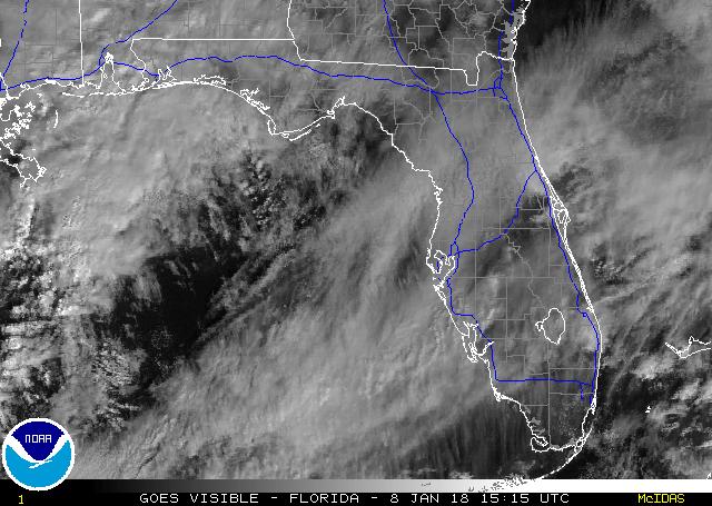
Impressive visible shot of the intense convection out head of a stronger-than-normal cold front for this time of year.
This front may even clear mainland South Florida before heading back as a warm front..impressive indeed.
Watch the sunny areas of SE FL -- I would expect big storms to blow up there later with the heating of the day and a very unstable atmosphere.
This front may even clear mainland South Florida before heading back as a warm front..impressive indeed.
Watch the sunny areas of SE FL -- I would expect big storms to blow up there later with the heating of the day and a very unstable atmosphere.
Last edited by gatorcane on Mon May 18, 2009 11:16 am, edited 1 time in total.
0 likes
-
cycloneye

- Admin

- Posts: 149505
- Age: 69
- Joined: Thu Oct 10, 2002 10:54 am
- Location: San Juan, Puerto Rico
Re: Models Develop a Disturbance Near Florida This Week
Aric is right,its time to look at actual observations and forget the models.Imagine a model that shows 4 lows between the NW Caribbean and GOM.That is what GFS has at the 12z at 96 hours.

0 likes
-
Aric Dunn
- Category 5
- Posts: 21238
- Age: 43
- Joined: Sun Sep 19, 2004 9:58 pm
- Location: Ready for the Chase.
- Contact:
Re:
gatorcane wrote::uarrow:
To be fair NAM and UKMET could be tracking pretty well. I'd like to see if these models verify or not.
but we need to pay attention to the hour to hour data and observation, no model can do that, expect the RUC and since we are looking at a non tropical low at the moment not a bad idea to see what its doing.. but still satellite analysis and surface obs will be our best bet for the rest of today since the models are still all over the place for genesis. whats that happens either non,hybrid,sub,or tropical the models will be less than useful beyond major pattern developments. this is the fun part anyway searching for the first site of the closed low forming( at the surface) lets see you find it first..!!
0 likes
-
vacanechaser

- Category 5
- Posts: 1461
- Joined: Wed Dec 03, 2003 9:34 pm
- Location: Portsmouth, Va
- Contact:
Re: Re:
Aric Dunn wrote:gatorcane wrote::uarrow:
To be fair NAM and UKMET could be tracking pretty well. I'd like to see if these models verify or not.
but we need to pay attention to the hour to hour data and observation, no model can do that, expect the RUC and since we are looking at a non tropical low at the moment not a bad idea to see what its doing.. but still satellite analysis and surface obs will be our best bet for the rest of today since the models are still all over the place for genesis. whats that happens either non,hybrid,sub,or tropical the models will be less than useful beyond major pattern developments. this is the fun part anyway searching for the first site of the closed low forming( at the surface) lets see you find it first..!!
ahh see, you done thrown out the challenge big man. .. lol.. wish i had the time to sit in front of the computer all day!!! lol...
whats up aric???
Jesse V. Bass III
http://www.vastormphoto.com
Hurricane Intercept Research Team
0 likes
-
Aric Dunn
- Category 5
- Posts: 21238
- Age: 43
- Joined: Sun Sep 19, 2004 9:58 pm
- Location: Ready for the Chase.
- Contact:
Re: Models Develop a Disturbance Near Florida This Week
here is my initial examination.. an average distance from the SE flow to the NE flow and area of relative calm wind, is the likely area for a closed low to form ..

0 likes
-
Aric Dunn
- Category 5
- Posts: 21238
- Age: 43
- Joined: Sun Sep 19, 2004 9:58 pm
- Location: Ready for the Chase.
- Contact:
Re: Re:
vacanechaser wrote:Aric Dunn wrote:gatorcane wrote::uarrow:
To be fair NAM and UKMET could be tracking pretty well. I'd like to see if these models verify or not.
but we need to pay attention to the hour to hour data and observation, no model can do that, expect the RUC and since we are looking at a non tropical low at the moment not a bad idea to see what its doing.. but still satellite analysis and surface obs will be our best bet for the rest of today since the models are still all over the place for genesis. whats that happens either non,hybrid,sub,or tropical the models will be less than useful beyond major pattern developments. this is the fun part anyway searching for the first site of the closed low forming( at the surface) lets see you find it first..!!
ahh see, you done thrown out the challenge big man. .. lol.. wish i had the time to sit in front of the computer all day!!! lol...
whats up aric???
Jesse V. Bass III
http://www.vastormphoto.com
Hurricane Intercept Research Team
Hey jesse saw mark at the conference where were you ?
also i did not throw out the challange i actually challenged everyone to analyze satellite and surface obs to try and find where the circ may form lol
0 likes
-
Stormcenter
- S2K Supporter
- Posts: 6689
- Joined: Wed Sep 03, 2003 11:27 am
- Location: Houston, TX
Re: Models Develop a Disturbance Near Florida This Week
Whatever is in the SE GOM
looks kind of interesting. I would
think this is the area to watch. IMO
http://www.ssd.noaa.gov/goes/east/gmex/loop-vis.html
looks kind of interesting. I would
think this is the area to watch. IMO
http://www.ssd.noaa.gov/goes/east/gmex/loop-vis.html
0 likes

-
vacanechaser
- Category 5
- Posts: 1461
- Joined: Wed Dec 03, 2003 9:34 pm
- Location: Portsmouth, Va
- Contact:
Re: Re:
Aric Dunn wrote:Hey jesse saw mark at the conference where were you ?
also i did not throw out the challange i actually challenged everyone to analyze satellite and surface obs to try and find where the circ may form lol
i was saving time for the season... trying too anyway.. i just bought a house so, burned up some leave earlier this year for that..
i know, i was just saying, sounded like a challenge.. you throw that out here on this board, you know you are gonna get it coming..!!! lol
Jesse V. Bass III
http://www.vastormphoto.com
Hurricane Intercept Research Team
0 likes
-
Aric Dunn
- Category 5
- Posts: 21238
- Age: 43
- Joined: Sun Sep 19, 2004 9:58 pm
- Location: Ready for the Chase.
- Contact:
Re: Re:
vacanechaser wrote:Aric Dunn wrote:Hey jesse saw mark at the conference where were you ?
also i did not throw out the challange i actually challenged everyone to analyze satellite and surface obs to try and find where the circ may form lol
i was saving time for the season... trying too anyway.. i just bought a house so, burned up some leave earlier this year for that..
i know, i was just saying, sounded like a challenge.. you throw that out here on this board, you know you are gonna get it coming..!!! lol
Jesse V. Bass III
http://www.vastormphoto.com
Hurricane Intercept Research Team
lol .. yeah probably hehe
well hopefully I will see you out this year if we get lucky/unlucky which ever way you look at it.. lol
I am working on gather up some money and buying some new toys for the season
0 likes
-
Aric Dunn
- Category 5
- Posts: 21238
- Age: 43
- Joined: Sun Sep 19, 2004 9:58 pm
- Location: Ready for the Chase.
- Contact:
Re:
AdamFirst wrote:I'm in one of those areas in Florida where the sun hasn't disappeared yet...got plenty of towering clouds to the west and we got some big cells developing ahead of the frontal boundary
Got some pretty big fireworks a'comin here
only a matter of time .. its coming !!!
0 likes
-
Ed Mahmoud
Re: Models Develop a Disturbance Near Florida This Week
If it wasn't for the recent outflow boundary barfed out, I'd say the Jamaica/Bahamas system was trying to develop a low level circulation.
0 likes
-
cycloneye
- Admin
- Posts: 149505
- Age: 69
- Joined: Thu Oct 10, 2002 10:54 am
- Location: San Juan, Puerto Rico
Re: Models Develop a Disturbance Near Florida This Week
The 12 UTC Analysis has a surface trough in the EGOM.

0 likes
-
AdamFirst

- S2K Supporter
- Posts: 2490
- Age: 36
- Joined: Thu Aug 14, 2008 10:54 am
- Location: Port Saint Lucie, FL
Re: Models Develop a Disturbance Near Florida This Week
Ed Mahmoud wrote:If it wasn't for the recent outflow boundary barfed out, I'd say the Jamaica/Bahamas system was trying to develop a low level circulation.
I saw something around there too, around 22 N, 77 W, looked like some low clouds were beginning to wrap around
I honestly can't tell the difference though between any lower, mid, or high level clouds so I'm refraining from saying anything
0 likes

-
Dean4Storms
- S2K Supporter
- Posts: 6358
- Age: 63
- Joined: Sun Aug 31, 2003 1:01 pm
- Location: Miramar Bch. FL
Re: Models Develop a Disturbance Near Florida This Week
I think I'm seeing a LL spin about 90 miles north of the western tip of Cuba, anyone else see this spin?
0 likes

Re: Models Develop a Disturbance Near Florida This Week
The ULL is becoming very pronounced around 27N-87W - looks to be drifting slowly SE - about where the ECM forecasted it. Shear is very high over most of the area so whatever low pressure develops will definitely be cold core to start out. The Euro essentially vertically stacks the low pressure underneath the ULL. Given the synoptics, this could turn out to be the most likely scenario.
http://www.meteo.psu.edu/rtwx/ewall/ECMWFTROPATL_0z/ecmwfloop.html
http://www.meteo.psu.edu/rtwx/ewall/ECMWFTROPATL_0z/ecmwfloop.html
0 likes
Who is online
Users browsing this forum: AnnularCane and 168 guests