Lets have the discussions about this non-tropical low here that with time may get some tropical caracteristics.
About this thread,it will remain open without limits in pages until if it occurs a new invest is up.
Low Pressure in Gulf of Mexico
Moderator: S2k Moderators
Forum rules

The posts in this forum are NOT official forecasts and should not be used as such. They are just the opinion of the poster and may or may not be backed by sound meteorological data. They are NOT endorsed by any professional institution or STORM2K. For official information, please refer to products from the National Hurricane Center and National Weather Service.
-
cycloneye

- Admin

- Posts: 149776
- Age: 69
- Joined: Thu Oct 10, 2002 10:54 am
- Location: San Juan, Puerto Rico
Low Pressure in Gulf of Mexico
0 likes

Re: Low Pressure near Florida Penninsula
Tuesday AM Analysis
Good Tuesday, all. This morning the HPC analyzed two weak surface lows at 09Z, one situated near Key West and the Dry Tortugas while the other is fixed in vicinity of Andros Island. The broad low south/southwest of the Keys is visible on doppler radar; both lows are apparent on shortwave-IR imagery. IR imagery reveals widespread moderate to deep convection continuing mainly offshore Florida in an area of deepest PW's, moisture transport, and precipitation potential placement. These precipitation/moisture fields are being dominated by mid-level - not surface - features, as the cut-off upper low has formed over the Central to Southwest Florida Peninsula. RUC2 analysis (12Z) captures this feature quite well, though the mid/upper low is likely a bit more elongated E-W per 13Z VAD profiles. This mid/upper low is presently nearly stationary, but is expected to retreat Wward today as midwest ridging builds Eward to the north. IRWV imagery shows the mid/upper low to be stationary given increased moisture fields aloft across the Eastern Florida Panhandle. This moisture surge westward well north of this feature likewise indicates that it is the primary meteorological feature in handling ongoing weather across the Ern Gulf, Florida, and SW Atlantic. IRWV trends during the past hour or two show that dry air offshore West Central Florida has ceased its eastward progression and has even back-tracked west with further moistening. This suggests that 1) deeper moisture aloft is fully rotating around the mid/upper low as it becomes better organized and 2) this feature may be starting to edge westward. For today, this will translate into deeper moisture fields presently east of the Peninsula edging back alongshore Florida's East Coast. Widespread shower activity with likely rain and embedded heavy showers/t'storms will be probable today, especially east of a line from Key West to Lake Okeechobbee to Orlando to Jacksonville.
Wind... a tight pressure gradient is ongoing across Northeast and parts of Central Florida. If the surface low near Key West further deepens, then the pressure gradient will likely expand a little with areas of Florida and Southeast Georgia north of a line from Port Charlotte to Melbourne seeing at least breezy conditions. General winds across these areas will likely become 15 to 25 mph sustained with gusts to 35 mph. Slightly higher winds will be felt along the Northeast Florida coast potentially extending as far south as Cape Canaveral during the afternoon. Gale-force gusts will be possible here for coastal communities.
Severe threat... The saturated, rain-cooled airmass across most of Florida precludes a notable severe threat today. With the upper feature deepening and cooler temperatures poised to establish aloft, an isolated strong to severe cell cannot be ruled out. The main threat from any stronger cells that get-going today will be strong wind gusts. While respectable helicity is found across parts of North Central Florida this morning, the lack of any focused forcing combined with little CAPE suggests that only a minimal risk for rotating storm cells exists. If the surface low wraps-up deeper and quicker, then it may be able to develop more organized bands of heavier showers/t'storms to move onshore Florida's East Coast this afternoon. Until deep sustained cells can form, however, the severe weather risk looks minimal today.
For rainfall, additional totals of 1 to 3 inches look to be in the works for much of the Peninsula with highest totals existing along the Northeast and East Central Florida areas. Locally higher amounts can be expected, especially if deeper convection moves back onshore this afternoon.
Tropical development... None likely during the next 48 hours. The Andros Island low is quite weak and is likely to dissipate or become absorbed in the larger scale non-tropical forcing farther west.
14Z Update... satellite imagery is showing new convective tops starting to fire in the more unstable airmass in place north of the Keys to offshore Southwest Florida. This activity will likely build during the next few hours and will fill-in some precipitation across parts of Central and South Florida.
(Am reposting since the previous active storms thread was locked; moderators feel free to delete if my cross-posting is inappropriate.)
- Jay
0 likes

Re: Low Pressure in EGOM / Model runs
Impressive radar view.
Uncheck the TOPO, counties and city boxes and animate.
http://radar.weather.gov/radar.php?prod ... W&loop=yes
Glad this isn't August.
Uncheck the TOPO, counties and city boxes and animate.
http://radar.weather.gov/radar.php?prod ... W&loop=yes
Glad this isn't August.
0 likes
-
Evil Jeremy

- S2K Supporter

- Posts: 5463
- Age: 32
- Joined: Mon Apr 10, 2006 2:10 pm
- Location: Los Angeles, CA
Re: Low Pressure in EGOM / Model runs
Can we at least unlock the thread for the Bahamas disturbance? Its still technically an invest, and even if that remains locked, what about the one in here in Talkin' Tropics?
0 likes

-
cycloneye
- Admin
- Posts: 149776
- Age: 69
- Joined: Thu Oct 10, 2002 10:54 am
- Location: San Juan, Puerto Rico
Re: Low Pressure in EGOM / Model runs
Evil Jeremy wrote:Can we at least unlock the thread for the Bahamas disturbance? Its still technically an invest, and even if that remains locked, what about the one in here in Talkin' Tropics?
That thread is unlocked until NRL no longer has 90L.Once that happens,then the thread moves to archieves forum.About this thread,it will remain open without limits in pages until if it occurs a new invest is up.
0 likes
-
hurricanefloyd5

- Category 5

- Posts: 1659
- Age: 45
- Joined: Sun May 02, 2004 10:53 am
- Location: Spartanburg
- Contact:
Re: Low Pressure in EGOM / Model runs
tailgater wrote:Impressive radar view.
Uncheck the TOPO, counties and city boxes and animate.
http://radar.weather.gov/radar.php?prod ... W&loop=yes
Glad this isn't August.
the low near or due west of Naples looks to be moving/drifting due southward and the convection is over and near the center according to the radar or am I wrong and just seeing things?
0 likes
-
HouTXmetro

- Category 5
- Posts: 3949
- Joined: Sun Jun 13, 2004 6:00 pm
- Location: District of Columbia, USA

Re: Low Pressure in Fla Penninsula / EGOM / Model runs
06Z UKMET deepens GOM low pressure over the next 48 hrs.
http://moe.met.fsu.edu/cgi-bin/ukmtc2.cgi?time=2009051906&field=Sea+Level+Pressure&hour=Animation
http://moe.met.fsu.edu/cgi-bin/ukmtc2.cgi?time=2009051906&field=Sea+Level+Pressure&hour=Animation
0 likes
Re: Low Pressure in Fla Penninsula / EGOM / Model runs
hurricanefloyd5 wrote:the low near or due west of Naples looks to be moving/drifting due southward and the convection is over and near the center according to the radar or am I wrong and just seeing things?
While I can clearly see some rotation offshore Naples, the lowest pressures are farther southeast (29.86inHg at Naples as of 10AM, 29.81inHg at Marathon and 29.82inHg at Virginia Key). Interestingly, the Florida mesonet and RUC2 pin the surface low offshore Miami/Dade County. Furthermore, the 12Z HPC surface analysis drapes the frontal boundary directly along the Southeast Florida coast (which makes sense per the mesonet grid) and does not indicate any surface low. I think we're not dealing with much of any organized surface low right now.
Interestingly, convergence is becoming better defined nearer the East Central and Southeast Florida coast and new showers are cropping up along the Atlantic coast of Palm Beach County and Treasure Coast.
- Jay
0 likes
Re: Low Pressure in EGOM / Model runs
hurricanefloyd5 wrote:tailgater wrote:Impressive radar view.
Uncheck the TOPO, counties and city boxes and animate.
http://radar.weather.gov/radar.php?prod ... W&loop=yes
Glad this isn't August.
the low near or due west of Naples looks to be moving/drifting due southward and the convection is over and near the center according to the radar or am I wrong and just seeing things?
There are a few lows in the area, I was refering to one the just east of Tampa, there's another one over the Keys and still another over the Bahamas along with an Upper Low just off Fla west coast.
0 likes
-
Evil Jeremy
- S2K Supporter
- Posts: 5463
- Age: 32
- Joined: Mon Apr 10, 2006 2:10 pm
- Location: Los Angeles, CA
Re: Low Pressure in Fla Penninsula / EGOM / Model runs
Certainly rotation around the Lake O area. Unfortunately this is keeping a lot of rain offshore. Hopefully SFL will get rain like yesterday later today.
0 likes

-
hurricanefloyd5
- Category 5
- Posts: 1659
- Age: 45
- Joined: Sun May 02, 2004 10:53 am
- Location: Spartanburg
- Contact:
Re:
gatorcane wrote:Here is the latest Mesoanalysis showing low-level wind flow across Florida:
this low is right over my sister's house
0 likes
-
gatorcane

- S2K Supporter
- Posts: 23708
- Age: 48
- Joined: Sun Mar 13, 2005 3:54 pm
- Location: Boca Raton, FL
Re: Low Pressure near Florida Penninsula
NEXRAD wrote:Tuesday AM Analysis
Severe threat... The saturated, rain-cooled airmass across most of Florida precludes a notable severe threat today. With the upper feature deepening and cooler temperatures poised to establish aloft, an isolated strong to severe cell cannot be ruled out. The main threat from any stronger cells that get-going today will be strong wind gusts. While respectable helicity is found across parts of North Central Florida this morning, the lack of any focused forcing combined with little CAPE suggests that only a minimal risk for rotating storm cells exists. If the surface low wraps-up deeper and quicker, then it may be able to develop more organized bands of heavier showers/t'storms to move onshore Florida's East Coast this afternoon. Until deep sustained cells can form, however, the severe weather risk looks minimal today.
- Jay
Another issue is the lack of heating across Fl today due to the extensive mid-level cloud cover. That should put a cap on widespread severe thunderstorm activity today, and may even limit the amount of rainfall across mainland FL that does not see any heating. The best chance of rain will be from rotating cells off of the GOM or Atlantic once the ULL moves a bit farther west.
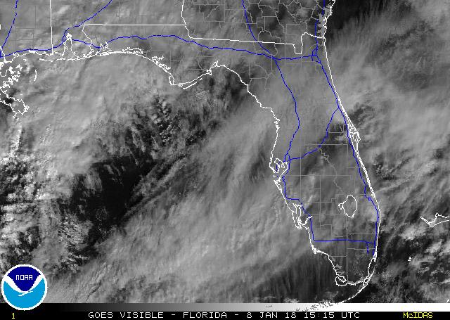
Latest VIS shot of Florida does show some sunshine trying to get through the cloud deck, that could be just enough heating to spark off some deep convection later on today. Point is that the heating potential couple with seabreeze convergence potential (lack of it) will be the main driving factor for any kind of severe weather.
http://www.ssd.noaa.gov/PS/FIRE/DATA/RT/FL/VIS/20.jpg
0 likes
-
cycloneye
- Admin
- Posts: 149776
- Age: 69
- Joined: Thu Oct 10, 2002 10:54 am
- Location: San Juan, Puerto Rico
Re: Low Pressure in Fla Penninsula / EGOM / Model runs
12 UTC Surface Analysis does not have surface low pressures in the area of interest.

0 likes
-
jlauderdal
- S2K Supporter
- Posts: 7240
- Joined: Wed May 19, 2004 5:46 am
- Location: NE Fort Lauderdale
- Contact:
Re: Low Pressure in Fla Penninsula / EGOM / Model runs
Evil Jeremy wrote:Certainly rotation around the Lake O area. Unfortunately this is keeping a lot of rain offshore. Hopefully SFL will get rain like yesterday later today.
we just had some sun so if we can keep that going for an hour two that should get things going in this setup, wont take much today
0 likes

Does look like there are several low pressure centers trying to work there way down the surface and there isn't really any major organisation to the broad area of lower pressure.
No tropical change for a while, may need to be watched as it gets towards the central gulf in about 3-4 days though.
No tropical change for a while, may need to be watched as it gets towards the central gulf in about 3-4 days though.
0 likes
-
floridasun78
- Category 5
- Posts: 3755
- Joined: Sun May 17, 2009 10:16 pm
- Location: miami fl
Re: Low Pressure in Fla Penninsula / EGOM / Model runs
it look like most rain going north of south fl we not going get big amount as forecast
0 likes
-
Dean4Storms
- S2K Supporter
- Posts: 6358
- Age: 63
- Joined: Sun Aug 31, 2003 1:01 pm
- Location: Miramar Bch. FL
Who is online
Users browsing this forum: WaveBreaking and 171 guests