GOM: INVEST 90L

Moderator: S2k Moderators

Message
Author
OpieStorm

Re: INVEST 90L

#281 Postby OpieStorm » Tue May 19, 2009 3:02 pm

Category 5 wrote:SEASON CANCEL :D

Image
0 likes   

User avatar
Lowpressure
S2K Supporter
S2K Supporter
Posts: 2032
Age: 58
Joined: Sun Sep 14, 2003 9:17 am
Location: Charlotte, North Carolina

Re: EX-INVEST 90L

#282 Postby Lowpressure » Tue May 19, 2009 4:06 pm

Wow, that was fast.
0 likes   

User avatar
Cookie
S2K Supporter
S2K Supporter
Posts: 477
Age: 37
Joined: Sun Dec 14, 2008 11:13 am
Location: Isle Of lewis scotland

Re: INVEST 90L

#283 Postby Cookie » Tue May 19, 2009 4:25 pm

OpieStorm wrote:
Category 5 wrote:SEASON CANCEL :D

Image


:lol: :lol:
0 likes   

User avatar
Hybridstorm_November2001
S2K Supporter
S2K Supporter
Posts: 2811
Joined: Sat Aug 21, 2004 2:50 pm
Location: SW New Brunswick, Canada
Contact:

Re: INVEST 90L

#284 Postby Hybridstorm_November2001 » Tue May 19, 2009 4:34 pm

OpieStorm wrote:
Category 5 wrote:SEASON CANCEL :D

Image


Indeed LOL!
0 likes   

User avatar
HURAKAN
Professional-Met
Professional-Met
Posts: 46086
Age: 38
Joined: Thu May 20, 2004 4:34 pm
Location: Key West, FL
Contact:

#285 Postby HURAKAN » Tue May 19, 2009 5:49 pm

Atmospheric pressures are quite low across South Florida. Currently in my house, 1007.1 mb. At 5:53 PM it was 1006.4 mb.
0 likes   

Aric Dunn
Category 5
Category 5
Posts: 21238
Age: 42
Joined: Sun Sep 19, 2004 9:58 pm
Location: Ready for the Chase.
Contact:

Re: EX-INVEST 90L

#286 Postby Aric Dunn » Tue May 19, 2009 6:20 pm

figured this goes in here...
instead of the other thread..
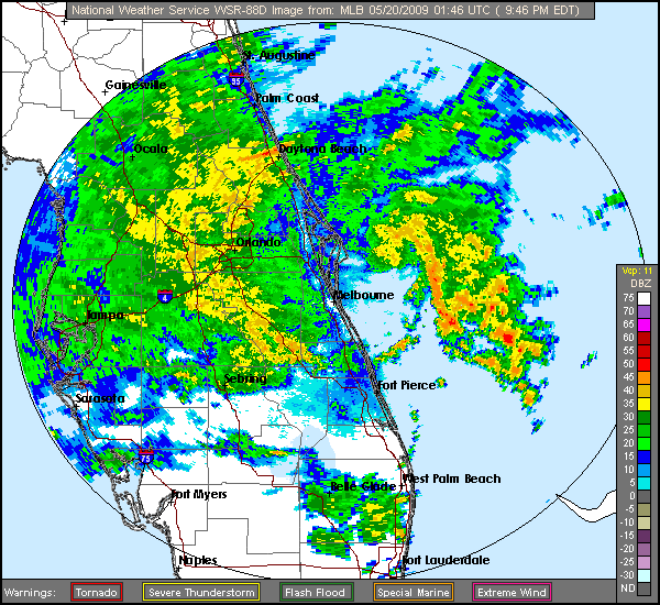
Aric Dunn wrote:hehe.. the remnants of 90L is circled in the image below.. been tracking it still has some circ to it.. lol probably some gusty winds to the central florida area..
you can see the leftover spin on long range radar people who have GR it shows up better. also in base velocity you can see the signature.. kind of funny i think.. lol

Image


Aric Dunn wrote:also check out the winds out at the 120 mile bouy ..!!! which is right in the middle of the remnants.

http://www.ndbc.noaa.gov/station_page.php?station=41010
nearly sustained TS force.. lol

that will all come ashore somewhere in central florida looks like just north of the cape..
0 likes   

User avatar
jasons2k
Storm2k Executive
Storm2k Executive
Posts: 8238
Age: 51
Joined: Wed Jul 06, 2005 12:32 pm
Location: The Woodlands, TX

#287 Postby jasons2k » Tue May 19, 2009 6:38 pm

What you can see on radar and confirmed by BV is an outflow boundry moving towards the coast. Not a positive sign for any development.
0 likes   

Aric Dunn
Category 5
Category 5
Posts: 21238
Age: 42
Joined: Sun Sep 19, 2004 9:58 pm
Location: Ready for the Chase.
Contact:

Re:

#288 Postby Aric Dunn » Tue May 19, 2009 6:41 pm

jasons wrote:What you can see on radar and confirmed by BV is an outflow boundry moving towards the coast. Not a positive sign for any development.


no no
did not say developments.. just the remnants. :)

just been tracking the left overs of 90L for fun
0 likes   

Aric Dunn
Category 5
Category 5
Posts: 21238
Age: 42
Joined: Sun Sep 19, 2004 9:58 pm
Location: Ready for the Chase.
Contact:

Re: EX-INVEST 90L

#289 Postby Aric Dunn » Tue May 19, 2009 8:25 pm

nearly onshore... lol

just nearby here in ormond beach 55 mph ... thats from the pressure gradient though


Image
0 likes   

Aric Dunn
Category 5
Category 5
Posts: 21238
Age: 42
Joined: Sun Sep 19, 2004 9:58 pm
Location: Ready for the Chase.
Contact:

#290 Postby Aric Dunn » Tue May 19, 2009 8:27 pm

the remnants are over the 20 miles bouy now

http://www.ndbc.noaa.gov/station_page.php?station=41009


Image

40kts

that will be on shore soon..

check the plot when it passed the 120 mile bouy.. look at the pressure..
Image
0 likes   

Aric Dunn
Category 5
Category 5
Posts: 21238
Age: 42
Joined: Sun Sep 19, 2004 9:58 pm
Location: Ready for the Chase.
Contact:

Re: EX-INVEST 90L

#291 Postby Aric Dunn » Tue May 19, 2009 9:22 pm

nearly ashore
Image
0 likes   

User avatar
HURAKAN
Professional-Met
Professional-Met
Posts: 46086
Age: 38
Joined: Thu May 20, 2004 4:34 pm
Location: Key West, FL
Contact:

#292 Postby HURAKAN » Tue May 19, 2009 9:28 pm

Image
0 likes   

meteorologyman
Category 2
Category 2
Posts: 541
Joined: Wed Mar 15, 2006 6:48 pm
Location: Florida, Kissimmee/St.CLoud

Re: EX-INVEST 90L

#293 Postby meteorologyman » Tue May 19, 2009 9:45 pm

It looks it will pass close to my area, I am in center nortern top of Osceola County about 30 min from Orlando
0 likes   

Aric Dunn
Category 5
Category 5
Posts: 21238
Age: 42
Joined: Sun Sep 19, 2004 9:58 pm
Location: Ready for the Chase.
Contact:

#294 Postby Aric Dunn » Tue May 19, 2009 9:52 pm

we have landfall. and i just saw a transfer blow..lol ..
0 likes   

User avatar
WeatherLovingDoc
S2K Supporter
S2K Supporter
Posts: 453
Joined: Fri Sep 05, 2008 10:08 pm
Location: Washington D.C.

Re:

#295 Postby WeatherLovingDoc » Tue May 19, 2009 10:10 pm

Aric Dunn wrote:we have landfall. and i just saw a transfer blow..lol ..


You still breathing there Aric? How high is the wind? Still have electricity?

Also have family nearby....Hope you all are well.
0 likes   

Aric Dunn
Category 5
Category 5
Posts: 21238
Age: 42
Joined: Sun Sep 19, 2004 9:58 pm
Location: Ready for the Chase.
Contact:

Re: Re:

#296 Postby Aric Dunn » Tue May 19, 2009 10:12 pm

WeatherLovingDoc wrote:
Aric Dunn wrote:we have landfall. and i just saw a transfer blow..lol ..


You still breathing there Aric? How high is the wind? Still have electricity?

Also have family nearby....Hope you all are well.


yep all is good.. its just fun.. some good gust :) lots of rain

my getting my fix !!! hold me over till the season gets going :)
0 likes   

User avatar
Category 5
Category 5
Category 5
Posts: 10074
Age: 35
Joined: Sun Feb 11, 2007 10:00 pm
Location: New Brunswick, NJ
Contact:

Re: EX-INVEST 90L

#297 Postby Category 5 » Tue May 19, 2009 10:18 pm

ZOMG 15 FOOT SURGE ON CAPE CANAVERAL :grrr:
0 likes   

User avatar
AdamFirst
S2K Supporter
S2K Supporter
Posts: 2491
Age: 36
Joined: Thu Aug 14, 2008 10:54 am
Location: Port Saint Lucie, FL

Re: EX-INVEST 90L

#298 Postby AdamFirst » Tue May 19, 2009 10:42 pm

When there's smoke, there's fire

BULLETIN - EAS ACTIVATION REQUESTED
TORNADO WARNING
NATIONAL WEATHER SERVICE MELBOURNE FL
1135 PM EDT TUE MAY 19 2009

THE NATIONAL WEATHER SERVICE IN MELBOURNE HAS ISSUED A

* TORNADO WARNING FOR...
CENTRAL LAKE COUNTY IN FLORIDA...
NORTHWESTERN ORANGE COUNTY IN FLORIDA...
THIS INCLUDES THE CITIES OF...ZELLWOOD...WINTER PARK...WINTER
GARDEN...WINDERMERE...PINE HILLS...OCOEE...MAITLAND...LOCKHART...
LAKE APOPKA...FAIRVIEW SHORES...APOPKA...
WESTERN SEMINOLE COUNTY IN FLORIDA...
THIS INCLUDES THE CITIES OF...WINTER SPRINGS...WEKIVA SPRINGS...
LONGWOOD...LAKE MARY...GOLDENROD...FOREST CITY...CASSELBERRY...
ALTAMONTE SPRINGS...

* UNTIL MIDNIGHT EDT.

* AT 1134 PM EDT...NATIONAL WEATHER SERVICE DOPPLER RADAR INDICATED A
SEVERE THUNDERSTORM CAPABLE OF PRODUCING A TORNADO NEAR
CASSELBERRY...MOVING WEST AT 40 MPH.

* THE TORNADO WILL BE NEAR...
ALTAMONTE SPRINGS...WEKIVA SPRINGS AND FAIRVIEW SHORES BY 1140 PM
EDT...
LOCKHART...WEKIWA SPRINGS STATE PARK...PINE HILLS AND FOREST CITY
BY 1145 PM EDT...
APOPKA BY 1150 PM EDT...
OCOEE BY 1155 PM EDT...
LAKE APOPKA BY MIDNIGHT EDT...
0 likes   

User avatar
CronkPSU
S2K Supporter
S2K Supporter
Posts: 2014
Joined: Sun Aug 07, 2005 10:44 pm
Location: Avalon Park, FL

Re: EX-INVEST 90L

#299 Postby CronkPSU » Tue May 19, 2009 10:57 pm

AdamFirst wrote:When there's smoke, there's fire

BULLETIN - EAS ACTIVATION REQUESTED
TORNADO WARNING
NATIONAL WEATHER SERVICE MELBOURNE FL
1135 PM EDT TUE MAY 19 2009

THE NATIONAL WEATHER SERVICE IN MELBOURNE HAS ISSUED A

* TORNADO WARNING FOR...
CENTRAL LAKE COUNTY IN FLORIDA...
NORTHWESTERN ORANGE COUNTY IN FLORIDA...
THIS INCLUDES THE CITIES OF...ZELLWOOD...WINTER PARK...WINTER
GARDEN...WINDERMERE...PINE HILLS...OCOEE...MAITLAND...LOCKHART...
LAKE APOPKA...FAIRVIEW SHORES...APOPKA...
WESTERN SEMINOLE COUNTY IN FLORIDA...
THIS INCLUDES THE CITIES OF...WINTER SPRINGS...WEKIVA SPRINGS...
LONGWOOD...LAKE MARY...GOLDENROD...FOREST CITY...CASSELBERRY...
ALTAMONTE SPRINGS...

* UNTIL MIDNIGHT EDT.

* AT 1134 PM EDT...NATIONAL WEATHER SERVICE DOPPLER RADAR INDICATED A
SEVERE THUNDERSTORM CAPABLE OF PRODUCING A TORNADO NEAR
CASSELBERRY...MOVING WEST AT 40 MPH.

* THE TORNADO WILL BE NEAR...
ALTAMONTE SPRINGS...WEKIVA SPRINGS AND FAIRVIEW SHORES BY 1140 PM
EDT...
LOCKHART...WEKIWA SPRINGS STATE PARK...PINE HILLS AND FOREST CITY
BY 1145 PM EDT...
APOPKA BY 1150 PM EDT...
OCOEE BY 1155 PM EDT...
LAKE APOPKA BY MIDNIGHT EDT...


yep...it is crazy here right now in apopka!
0 likes   

User avatar
CronkPSU
S2K Supporter
S2K Supporter
Posts: 2014
Joined: Sun Aug 07, 2005 10:44 pm
Location: Avalon Park, FL

Re: EX-INVEST 90L

#300 Postby CronkPSU » Tue May 19, 2009 11:13 pm

and now we are back to regular old drizzle for a few hours
0 likes   


Return to “2009”

Who is online

Users browsing this forum: No registered users and 5 guests