Nothing like that going on over here in Biloxi, all's quiet. Looks like my relatives in Lucedale will get more out of this system than I will if it continues on it's present path.Dean4Storms wrote:BULLETIN - EAS ACTIVATION REQUESTED
SEVERE THUNDERSTORM WARNING
NATIONAL WEATHER SERVICE MOBILE AL
844 AM CDT SAT MAY 23 2009
THE NATIONAL WEATHER SERVICE IN MOBILE HAS ISSUED A
* SEVERE THUNDERSTORM WARNING FOR...
SOUTHWESTERN MOBILE COUNTY IN SOUTHWEST ALABAMA...
* UNTIL 915 AM CDT
* AT 844 AM CDT...THE PUBLIC REPORTED A LINE OF VERY STRONG WINDS
ASSOCIATED WITH A BAND OF SHOWERS AND ISOLATED THUNDERSTORMS
IN EXCESS OF 60 MPH. THE LEADING EDGE OF THESE WINDS WERE LOCATED
ALONG A LINE EXTENDING FROM BAYOU LA BATRE TO SAINT ELMO TO
IRVINGTON...AND MOVING NORTHWEST AT 15 MPH.
* THE DAMAGING WINDS WILL BE NEAR...
I10 AND MCDONALD ROAD BY 845 AM CDT...
GRAND BAY BY 905 AM CDT...
DEES BY 915 AM CDT...
PRECAUTIONARY/PREPAREDNESS ACTIONS...
DAMAGING WINDS ESTIMATED UP TO 60 MPH WERE REPORTED AT ALABAMA PORT
WITH A MACROBURST...AND TORE BARK OF TREES AND THREW AROUND OTHER
UNSECURED ITEMS. THIS IS A DANGEROUS STORM...SEEK SAFE SHELTER AND
STAY AWAY FROM WINDOWS!
GOM: INVEST 90L
Moderator: S2k Moderators
-
attallaman
Re:
0 likes


-
tolakram
- Admin

- Posts: 20186
- Age: 62
- Joined: Sun Aug 27, 2006 8:23 pm
- Location: Florence, KY (name is Mark)
Re: GOM: INVEST 90L
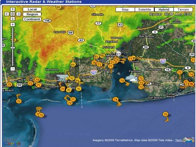
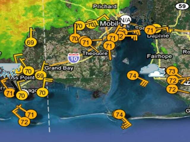
Looking at all the observation stations on shore it appears the center, or a center, moved ashore just west of Mobile Bay, near an area named Portersville Bay on the map. Max sustained winds were between 30 and 35MPH, which would be around 30 knots.
You can see on this map that the center was not well defined, so while the winds may have qualified it for a TD the circulation did not. In my opinion.
http://www.wunderground.com/wundermap/? ... fd=0&pix=0
You can see on this map that the center was not well defined, so while the winds may have qualified it for a TD the circulation did not. In my opinion.
http://www.wunderground.com/wundermap/? ... fd=0&pix=0
0 likes


Re:
Dean4Storms wrote:I believe this was a TC.
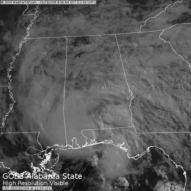
I initially thought the same when I noted the Fort Morgan, AL, station reporting sustained winds above 34-knots from 7:48 until 8:00 AM along with the Daupin Island pressure report down to 1003-1004 mb. While the system did present a reasonable satellite appearance, clear surface rotation, and a tight vortex on radar, I still wonder whether about it being a tropical storm/tropical cyclone. Technically the winds and pressure do meet tropical storm strength. That said, does a less than 30-minute swath of tropical storm force winds with a circulating system qualify for "tropical storm" (or even "tropical depression")? Would such short-lived systems with more isolated impacts be better classified as severe local storms (as NWS Mobile is obviously treating it this morning)?
I don't have a good answer, but as we're able to observe the oceans with finer detail and spot strangely tiny storm systems (like last year's Marco), I think the professionals are going to need to fine-tune TC definitions. A duration criteria could work, if such isn't already formally in place.
- Jay
0 likes
-
cycloneye

- Admin
- Posts: 149507
- Age: 69
- Joined: Thu Oct 10, 2002 10:54 am
- Location: San Juan, Puerto Rico
Re: GOM: INVEST 90L
Maybe they will go back and look at it after the season is over to see if it merits any upgrade at Best Track.
0 likes
-
CrazyC83
- Professional-Met

- Posts: 34315
- Joined: Tue Mar 07, 2006 11:57 pm
- Location: Deep South, for the first time!
Re: GOM: INVEST 90L
If it were to be upgraded, I would start the BT at 1800Z yesterday, just as it started to develop solid convection.
This is entirely unofficial, but a possible BT (note I only use depression/storm since it is still to be determined if it was a TC):
22/1800 - 27.0 / 87.6 - 25 kt - 1006mb - Depression
23/0000 - 27.7 / 87.8 - 30 kt - 1005mb
23/0600 - 28.6 / 88.4 - 30 kt - 1004mb
23/1200 - 29.8 / 88.4 - 35 kt - 1002mb - Storm
23/1400 - 30.4 / 88.5 - 35 kt - 1001mb - Landfall east of Pascagoula, MS and minimum pressure
23/1800 - 31.1 / 88.6 - 30 kt - 1001mb - Depression
Last edited by CrazyC83 on Sat May 23, 2009 12:49 pm, edited 1 time in total.
0 likes
-
Ed Mahmoud
Re: GOM: INVEST 90L
Soon to be ex-90L, which I think was at least an STD, has yet to provide any rain for my lawn way over here in SE Texas. Odd that the dewpoint has been rising on a Northeast wind.
Odd clouds yesterday. The cumulus had some vertical development, but most stopped growing at a high based stratus deck, which had only patchy holes revealing blue sky, a few punched past and produced showers.
But multilayered clouds, high humidity and a Northeast wind, it almost felt like something was brewing in the Gulf and headed closer than the MS/AL state line.
0 likes

Re: GOM: INVEST 90L
i guess you could say the rain this morning in Palm beach county, FL was associated with 90L
currently under a flood warning....with areas of 6-8 inch rainfalls in part of Boca Raton just in the last FEW hours.
(3) inches at my house brings the total to 9-10 inches since monday...
currently under a flood warning....with areas of 6-8 inch rainfalls in part of Boca Raton just in the last FEW hours.
(3) inches at my house brings the total to 9-10 inches since monday...
0 likes
-
OpieStorm
Re: GOM: INVEST 90L
It was pretty rough here (pensacola) early this morning with very heavy rain and gusty wind but it's calmed down now.
0 likes

The poor weather caused in part by 90L has forced the postponement of SS Atlantis' return to Earth.
http://news.bbc.co.uk/2/hi/science/nature/8062773.stm
http://news.bbc.co.uk/2/hi/science/nature/8062773.stm
0 likes
Re: GOM: INVEST 90L
This morning's rain due more to convergence line and short wave moving up from the keys than 90L for se fl...
AREA FORECAST DISCUSSION...UPDATED
NATIONAL WEATHER SERVICE MIAMI FL
1038 AM EDT SAT MAY 23 2009
.UPDATE...
THIS MORNING THERE HAS BEEN A CONVERGENCE LINE OF SHOWERS AND
THUNDERSTORMS OVER THE METRO AREAS OF PALM BEACH COUNTY, AND
WESTERN METRO AREAS OF BROWARD COUNTY...DUE TO THE DRAINAGE FLOW
FROM THE LAND AND THE EASTERLY WIND FLOW FROM THE ATLANTIC WATERS.
AT THE SAME TIME...A SHORT WAVE IN THE MIDDLE OF THE ATMOSPHERE HAS
ALSO BEEN WORKING NORTH FROM THE FLORIDA KEYS INTO SOUTH FLORIDA.
THE SHORT WAVE WILL CONTINUE TO MOVE NORTH THROUGH THE CWA THIS
AFTERNOON...AS THE CONVERGENCE LINE SHOULD PUSH INLAND INTO THE
INTERIOR AREAS OF SOUTH FLORIDA. THIS WILL REFOCUS THE ACTIVITY
FROM THE EAST COAST METRO AREAS INTO THE INTERIOR AREAS ESPECIALLY
OVER THE LAKE OKEECHOBEE AREA.
THEREFORE...HAVE INCREASE THE POPS TO LIKELY THIS MORNING FOR
METRO PALM BEACH INTO BROWARD COUNTIES...BEFORE DECREASING THEM
BACK TO CHANCE THIS AFTERNOON. THE INTERIOR AREAS WILL REMAIN IN
THE LIKELY CAT TODAY...WITH THE WEST COAST METRO AREAS IN THE
CHANCE CAT.
cpdaman wrote:i guess you could say the rain this morning in Palm beach county, FL was associated with 90L
currently under a flood warning....with areas of 6-8 inch rainfalls in part of Boca Raton just in the last FEW hours.
(3) inches at my house brings the total to 9-10 inches since monday...
0 likes

Re: GOM: INVEST 90L
I guess the sensor at Hollingers Is. is broken

Code: Select all
AP513 (APRSWXNET) WB4QEV-4 Hollingers Is. AL US
time    slp         t / td          dir / spd / gst/pcp   presWx & skyCover & Visibility
(UTC)  (mb)          (F)                    (mph)  (in.)                          (mi)
1457 ------(Z) 73.0(V)/-----(Z) 107°(Q)/073(Q)/---/0.00"
1354 ------(Z) 71.0(V)/-----(Z)  49°(Q)/028(Q)/---/0.00"
0 likes
-
attallaman
Who is online
Users browsing this forum: Google Adsense [Bot] and 13 guests