
GOM: INVEST 90L
Moderator: S2k Moderators
-
HURAKAN

- Professional-Met

- Posts: 46084
- Age: 39
- Joined: Thu May 20, 2004 4:34 pm
- Location: Key West, FL
- Contact:
Re: GOM: INVEST 90L
90L comes close to being the season's first named storm
Posted by: JeffMasters, 5:30 PM GMT on May 23, 2009
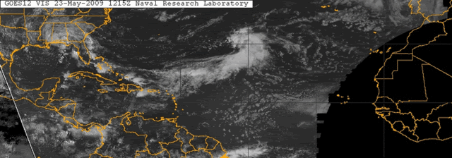
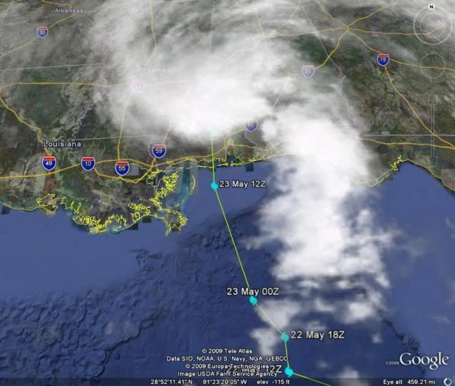
The large extratropical storm (90L) that has been pounding Florida, the Bahamas, and Haiti this week with heavy rain and high surf has moved ashore over Mississippi. Last night and this morning, the storm put on an impressive burst of heavy thunderstorm activity and came close to becoming a subtropical or tropical depression. Winds at the Fort Morgan, AL station were 44 mph, gusting to 52 mph, and winds at Dauphin Island, Alabama coastal station were sustained at 39 mph, gusting to 48 mph at between 8am and 10am EDT this morning. While these winds were in excess of the 39 mph threshold of tropical storm force, both measurements were taken at elevations higher than the international wind measurement standard of ten meters, so the top measured winds of 90L were actually slightly less than tropical storm force. Had 90L spent another six hours over water, it very likely would have been declared a tropical/subtropical depression/storm.
The circulation around 90L continues to mean rain for Florida, but the rains will be lessening today. Rainfall amounts as high as 28 inches were measured this week in Northern Florida at Brunnell. Rainfall amounts of 2 - 3 inches have accumulated along the Alabama, Mississippi, and Florida Panhandle coasts from 90L so far (Figure 1).

Posted by: JeffMasters, 5:30 PM GMT on May 23, 2009
The large extratropical storm (90L) that has been pounding Florida, the Bahamas, and Haiti this week with heavy rain and high surf has moved ashore over Mississippi. Last night and this morning, the storm put on an impressive burst of heavy thunderstorm activity and came close to becoming a subtropical or tropical depression. Winds at the Fort Morgan, AL station were 44 mph, gusting to 52 mph, and winds at Dauphin Island, Alabama coastal station were sustained at 39 mph, gusting to 48 mph at between 8am and 10am EDT this morning. While these winds were in excess of the 39 mph threshold of tropical storm force, both measurements were taken at elevations higher than the international wind measurement standard of ten meters, so the top measured winds of 90L were actually slightly less than tropical storm force. Had 90L spent another six hours over water, it very likely would have been declared a tropical/subtropical depression/storm.
The circulation around 90L continues to mean rain for Florida, but the rains will be lessening today. Rainfall amounts as high as 28 inches were measured this week in Northern Florida at Brunnell. Rainfall amounts of 2 - 3 inches have accumulated along the Alabama, Mississippi, and Florida Panhandle coasts from 90L so far (Figure 1).
0 likes
-
cycloneye

- Admin

- Posts: 149508
- Age: 69
- Joined: Thu Oct 10, 2002 10:54 am
- Location: San Juan, Puerto Rico
Re: GOM: INVEST 90L
Last Special Tropical Weather Outlook
000
ABNT20 KNHC 231732
TWOAT
SPECIAL TROPICAL WEATHER OUTLOOK
NWS TPC/NATIONAL HURRICANE CENTER MIAMI FL
130 PM EDT SAT MAY 23 2009
FOR THE NORTH ATLANTIC...CARIBBEAN SEA AND THE GULF OF MEXICO...
SATELLITE IMAGERY...RADAR DATA...AND SURFACE OBSERVATIONS INDICATE
THAT THE AREA OF LOW PRESSURE THAT WAS OVER THE NORTH-CENTRAL GULF
OF MEXICO THIS MORNING HAS MOVED INLAND NEAR THE ALABAMA-MISSISSIPPI
BORDER. ALTHOUGH TROPICAL CYCLONE DEVELOPMENT IS NOT EXPECTED...
THIS SYSTEM IS LIKELY TO PRODUCE LOCALLY HEAVY RAINS OVER PORTIONS
OF THE SOUTHEASTERN UNITED STATES DURING THE NEXT DAY OR TWO. SEE
STATEMENTS FROM LOCAL NATIONAL WEATHER SERVICE FORECAST OFFICES FOR
ADDITIONAL INFORMATION. THIS WILL BE THE LAST SPECIAL TROPICAL
WEATHER OUTLOOK ON THIS SYSTEM.
$$
FORECASTER PASCH/KIMBERLAIN
http://www.storm2k.org/weather/hw3.php? ... hwvmetric=
0 likes
-
Bailey1777
- S2K Supporter

- Posts: 962
- Joined: Mon Jul 31, 2006 6:23 pm
- Location: Houston, Texas
-
CrazyC83
- Professional-Met
- Posts: 34315
- Joined: Tue Mar 07, 2006 11:57 pm
- Location: Deep South, for the first time!
Re:
Bailey1777 wrote:-Ok yesterday when all the models came out I jokingly did my own saying it would come ashore at 30.2 - 87.8. How close was I to where it officially came ashore?
It looked to be around 30.4/88.5.
0 likes
-
cycloneye
- Admin
- Posts: 149508
- Age: 69
- Joined: Thu Oct 10, 2002 10:54 am
- Location: San Juan, Puerto Rico
Re: GOM: INVEST 90L
0 likes
-
Category 5

- Category 5

- Posts: 10074
- Age: 36
- Joined: Sun Feb 11, 2007 10:00 pm
- Location: New Brunswick, NJ
- Contact:
-
Brent
- S2K Supporter
- Posts: 38755
- Age: 37
- Joined: Sun May 16, 2004 10:30 pm
- Location: Tulsa Oklahoma
- Contact:
Re: GOM: INVEST 90L
Close but no cigar. Nice practice run before the season officially starts.
0 likes

-
MGC

- S2K Supporter
- Posts: 5940
- Joined: Sun Mar 23, 2003 9:05 pm
- Location: Pass Christian MS, or what is left.
Re: GOM: INVEST 90L
I think 90L was a TD last night based on the surface observations and satellite presentation. We shall see what the NHC does in the post season......MGC
0 likes
-
Hurricanehink

- S2K Supporter
- Posts: 2045
- Joined: Sun Nov 16, 2003 2:05 pm
- Location: New Jersey
Re: GOM: INVEST 90L
If it didn't have gale force winds, then don't expect anything any post-season upgrade. Tropical depressions aren't included in HURDAT, so there wouldn't be any reason to classify it. At least, I can't think of any tropical depressions that were upgraded in post-analysis.
0 likes
-
wxman57

- Moderator-Pro Met

- Posts: 23175
- Age: 68
- Joined: Sat Jun 21, 2003 8:06 pm
- Location: Houston, TX (southwest)
Re: GOM: INVEST 90L
Squalls with 30-40 mph winds alone doesn't make it a TD/TS. There is a requirement for at least some degree of organization. That area of squalls was well removed from a rather broad center. Just too disorganized to classify.
0 likes
-
Cryomaniac
- Category 5
- Posts: 1289
- Joined: Tue Aug 15, 2006 2:26 pm
- Location: Newark, Nottinghamshire, UK
- Contact:
Re: GOM: INVEST 90L
MGC wrote:I think 90L was a TD last night based on the surface observations and satellite presentation. We shall see what the NHC does in the post season......MGC
To be honest I doubt they'd upgrade a marginal TD postseason. Even if it was technically a TD, which seems unlikely.
0 likes

Who is online
Users browsing this forum: No registered users and 20 guests