Now up on Navy site...
http://www.nrlmry.navy.mil/tc_pages/tc_home.html
EAST COAST : Tropical Depression ONE
Moderator: S2k Moderators
-
srainhoutx

- S2K Supporter

- Posts: 6919
- Age: 68
- Joined: Sun Jan 14, 2007 11:34 am
- Location: Haywood County, NC
- Contact:
EAST COAST : Tropical Depression ONE
Last edited by srainhoutx on Tue May 26, 2009 8:43 am, edited 1 time in total.
0 likes
-
wxman57

- Moderator-Pro Met

- Posts: 23170
- Age: 68
- Joined: Sat Jun 21, 2003 8:06 pm
- Location: Houston, TX (southwest)
Re: Invest 91L Near The Bahamas
Pressures are high in the area and SSTs are well below normal threshold for tropical development. Slim shot at it becoming an STD or STS before it heads out to sea tomorrow night - very slim. I don't think that the NHC really thinks it'll develop. They didn't even identify a disturbance there on their tropical outlook. Probably just doing a bit of pre-season verifying that everything is in working order.
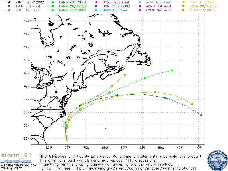
WHXX01 KWBC 261243
CHGHUR
TROPICAL CYCLONE GUIDANCE MESSAGE
NWS TPC/NATIONAL HURRICANE CENTER MIAMI FL
1243 UTC TUE MAY 26 2009
DISCLAIMER...NUMERICAL MODELS ARE SUBJECT TO LARGE ERRORS.
PLEASE REFER TO NHC OFFICIAL FORECASTS FOR TROPICAL CYCLONE
AND SUBTROPICAL CYCLONE INFORMATION.
ATLANTIC OBJECTIVE AIDS FOR
DISTURBANCE INVEST (AL912009) 20090526 1200 UTC
...00 HRS... ...12 HRS... ...24 HRS. .. ...36 HRS...
090526 1200 090527 0000 090527 1200 090528 0000
LAT LON LAT LON LAT LON LAT LON
BAMS 29.5N 75.3W 30.9N 75.5W 32.8N 75.2W 34.7N 74.2W
BAMD 29.5N 75.3W 31.5N 75.6W 33.6N 75.5W 35.7N 74.4W
BAMM 29.5N 75.3W 31.2N 75.4W 33.1N 75.1W 34.9N 73.9W
LBAR 29.5N 75.3W 31.9N 75.0W 34.1N 74.5W 36.2N 72.6W
SHIP 25KTS 31KTS 37KTS 42KTS
DSHP 25KTS 31KTS 37KTS 42KTS
...48 HRS... ...72 HRS... ...96 HRS. .. ..120 HRS...
090528 1200 090529 1200 090530 1200 090531 1200
LAT LON LAT LON LAT LON LAT LON
BAMS 36.7N 71.7W 40.5N 63.8W 43.8N 54.4W 45.6N 47.0W
BAMD 37.4N 71.8W 39.9N 61.7W 39.3N 48.8W 35.4N 39.3W
BAMM 36.5N 71.6W 39.4N 63.0W 40.7N 51.6W 37.9N 41.8W
LBAR 37.5N 69.5W 38.1N 58.0W 36.5N 44.7W .0N .0W
SHIP 45KTS 51KTS 47KTS 39KTS
DSHP 45KTS 51KTS 47KTS 39KTS
...INITIAL CONDITIONS...
LATCUR = 29.5N LONCUR = 75.3W DIRCUR = 355DEG SPDCUR = 14KT
LATM12 = 26.7N LONM12 = 74.6W DIRM12 = 353DEG SPDM12 = 14KT
LATM24 = 24.0N LONM24 = 75.1W
WNDCUR = 25KT RMAXWD = 45NM WNDM12 = 20KT
CENPRS = 1009MB OUTPRS = 1012MB OUTRAD = 300NM SDEPTH = M
RD34NE = 0NM RD34SE = 0NM RD34SW = 0NM RD34NW = 0NM
$$
NNNN
0 likes
-
srainhoutx
- S2K Supporter
- Posts: 6919
- Age: 68
- Joined: Sun Jan 14, 2007 11:34 am
- Location: Haywood County, NC
- Contact:
Re: Invest 91L Near The Bahamas
I was actually a bit surprised to see it declared an invest. I agree that this will not make it to STD or TD status.
0 likes
-
srainhoutx
- S2K Supporter
- Posts: 6919
- Age: 68
- Joined: Sun Jan 14, 2007 11:34 am
- Location: Haywood County, NC
- Contact:
-
wxman57
- Moderator-Pro Met
- Posts: 23170
- Age: 68
- Joined: Sat Jun 21, 2003 8:06 pm
- Location: Houston, TX (southwest)
Re: Invest 91L East Coast
It does have some nice mid-level rotation now, but I can't find any rotation at the surface. I don't know about that estimate of 1009mb in the region. Some obs nearby are 1015mb. Has a nice eye, though. 
0 likes

-
HURAKAN

- Professional-Met

- Posts: 46084
- Age: 39
- Joined: Thu May 20, 2004 4:34 pm
- Location: Key West, FL
- Contact:
Disturbance 91L forms near North Carolina
An area of disturbed weather, dubbed "91L" by the National Hurricane Center, has formed a few hundred miles southeast of North Carolina. The disturbance is over waters of 25 - 26°C and has wind shear of 10 - 15 knots over it, and these conditions are marginally favorable for some slow development to occur over the next 24 - 36 hours. The disturbance will track northwards towards North Carolina's Outer Banks over the next 24 - 36 hours, then get swept northeastwards out to sea. It is unlikely that the disturbance has enough time to develop into a tropical depression. However, the storm should bring winds of 20 - 25 mph and heavy rain to North Carolina's Cape Hatteras on Wednesday.
Jeff Masters
0 likes

-
wxman57
- Moderator-Pro Met
- Posts: 23170
- Age: 68
- Joined: Sat Jun 21, 2003 8:06 pm
- Location: Houston, TX (southwest)
Re: Invest 91L East Coast
SSTs in its path are only 75-76F at most, and closer to 72F for the next 12 hours. Not enough for pure tropical development. Nearest observation is now about 200 miles away, so that's no help. Those obs do indicate that a surface low may be forming, however.

Last edited by wxman57 on Tue May 26, 2009 9:22 am, edited 1 time in total.
0 likes
-
Ed Mahmoud
Re: Invest 91L East Coast
Faster than I expected...
Note- lower level convergence is improving since I posted last night...
Color satellite loop
This is smaller than original. Click this bar to view the full image. The original is 980x680, size 150KB
Shear is higher than what is considered favorable, but isn't excessive, the streamlines seem to suggest the clouds are just West of a weak anticyclone, and in the upward motion region of the jet.
I have no idea if this will develop, but I'll unoficially give it 33.3% chance of becoming 91L by lunch time Wednesday. No better than that, CIMMS low level convergence map not looking impressive.
Note- lower level convergence is improving since I posted last night...
0 likes
-
OuterBanker
- S2K Supporter
- Posts: 1761
- Joined: Wed Feb 26, 2003 10:53 am
- Location: Nags Head, NC
- Contact:
Several things going on here. First of course is that the center is over too cool water to develop. But as JB points out, the more powerfull and developed tsorms are away from the center to the N and NW of the center over warmer waters. This indicates a warm core center. The invest is also heading NNW toward the warmer waters of the Gulf Stream. So will it travel enough west to get into the warmer waters. Will it stay off shore before making the turn, or will it brush the OBX on it's way out.
Stay turned for As the Storm Turns.
BTW, 1km image is not on NRL site yet. But the XML link to Google Earth works fine (what a great link, the NRL links to Google Earth that is).
Stay turned for As the Storm Turns.
BTW, 1km image is not on NRL site yet. But the XML link to Google Earth works fine (what a great link, the NRL links to Google Earth that is).
0 likes
-
wxman57
- Moderator-Pro Met
- Posts: 23170
- Age: 68
- Joined: Sat Jun 21, 2003 8:06 pm
- Location: Houston, TX (southwest)
Re: Invest 91L East Coast
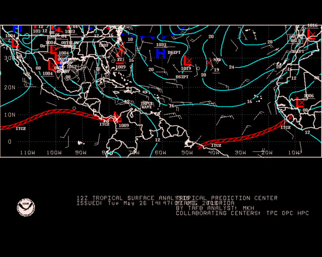
Here's a combo satellite image and surface obs. Not very impressive yet.

Last edited by wxman57 on Tue May 26, 2009 9:38 am, edited 1 time in total.
0 likes

Re: Invest 91L East Coast
Noteable May storm...it has happened in almost the exact same region (though not predicting anything like the Cat 3 Able was able to become)

0 likes


-
wxman57
- Moderator-Pro Met
- Posts: 23170
- Age: 68
- Joined: Sat Jun 21, 2003 8:06 pm
- Location: Houston, TX (southwest)
Re: Invest 91L East Coast
Convection remains sparse, SSTs are low, shear is high, environmental pressures are on the high side. Development chances are very, very low.
0 likes
-
Dean4Storms
- S2K Supporter
- Posts: 6358
- Age: 63
- Joined: Sun Aug 31, 2003 1:01 pm
- Location: Miramar Bch. FL

Who is online
Users browsing this forum: No registered users and 6 guests