Florida Weather
Moderator: S2k Moderators
Forum rules

The posts in this forum are NOT official forecast and should not be used as such. They are just the opinion of the poster and may or may not be backed by sound meteorological data. They are NOT endorsed by any professional institution or STORM2K.
-
HURAKAN

- Professional-Met

- Posts: 46084
- Age: 38
- Joined: Thu May 20, 2004 4:34 pm
- Location: Key West, FL
- Contact:
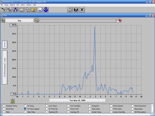
The most eventful day so far this year, weatherwise, has happened to me today. This line of storms produced wind gusts up to 39 mph, measured by my anenometer, and it's now pouring. I got video that I will load later one to show the arrangement of the garbage cans in my neighborhood thanks to the wind.
0 likes
-
gatorcane

- S2K Supporter

- Posts: 23708
- Age: 48
- Joined: Sun Mar 13, 2005 3:54 pm
- Location: Boca Raton, FL
Just another typical rainy season day in Southern Florida, with clear skies in the morning giving way to widespread convection by 3pmEST.
This VIS loop is neat to see the blowup of convection that we are seeing now on a daily basis. You can put your clock on when the rain will start each day usually between 1pm and 3pm with lingering convection into the evening.
http://www.ssd.noaa.gov/PS/FIRE/fires-fl-vis-loop.html
This VIS loop is neat to see the blowup of convection that we are seeing now on a daily basis. You can put your clock on when the rain will start each day usually between 1pm and 3pm with lingering convection into the evening.
http://www.ssd.noaa.gov/PS/FIRE/fires-fl-vis-loop.html
Last edited by gatorcane on Tue May 26, 2009 2:22 pm, edited 6 times in total.
0 likes

Re: Florida Weather Thread: Rainy season is here
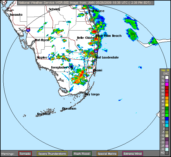
Impressive winds with this line of storm...potentially 60 mph+!!! Downed trees and powerlines have been reported.
SEVERE WEATHER STATEMENT
NATIONAL WEATHER SERVICE MIAMI FL
326 PM EDT TUE MAY 26 2009
...A SEVERE THUNDERSTORM WARNING REMAINS IN EFFECT UNTIL 400 PM EDT
FOR NORTHEASTERN MIAMI-DADE COUNTY...
AT 322 PM EDT...NATIONAL WEATHER SERVICE DOPPLER RADAR CONTINUED TO
INDICATE A LINE OF SEVERE THUNDERSTORMS PRODUCING DAMAGING WINDS IN
EXCESS OF 60 MPH. THESE STORMS WERE LOCATED ALONG A LINE EXTENDING
FROM BAL HARBOUR TO 6 MILES EAST OF PERRINE...MOVING EAST AT 25 MPH.
TRAINED SPOTTERS EARLIER REPORTED TREES DOWN, PENNY SIZED HAIL, AND
SPORADIC POWER OUTAGES ACROSS METRO MIAMI.
WIND DAMAGE WITH THIS STORM WILL OCCUR WELL AHEAD OF ANY RAIN OR
LIGHTNING. DO NOT WAIT FOR THE SOUND OF THUNDER BEFORE TAKING COVER.
SEEK SHELTER IMMEDIATELY INSIDE A STURDY STRUCTURE AND STAY AWAY FROM
WINDOWS.
0 likes
-
dolebot_Broward_NW
- Category 2

- Posts: 529
- Joined: Fri Sep 10, 2004 6:38 am
-
gatorcane
- S2K Supporter
- Posts: 23708
- Age: 48
- Joined: Sun Mar 13, 2005 3:54 pm
- Location: Boca Raton, FL
Re: Florida Weather Thread: Rainy season is here
Very large, severe cells are developing in interior South Florida in the Everglades, south of Lake O heading westward.
Its probably pretty unlikely they will hold together on their eastward treck towards the metro areas of Palm Beach county, but if a seabreeze develops and some cloud cover over metro areas from previous storms earlier today can dissipate, then these storms may hold together.
http://radar.weather.gov/radar.php?rid= ... 1&loop=yes
0 likes
-
HURAKAN
- Professional-Met
- Posts: 46084
- Age: 38
- Joined: Thu May 20, 2004 4:34 pm
- Location: Key West, FL
- Contact:
Re: Florida Weather Thread: Rainy season is here
HAIL
WIND
Code: Select all
1845    75    CORAL SPRINGS    BROWARD    FL   2627    8027   PENNY SIZED HAIL 106 WAY CORAL SPRINGS (MFL)

1900   100    HIALEAH    MIAMI-DADE    FL   2586    8029   NICKLE TO QUARTER SIZED HAIL REPORTED BY PUBLIC 1881 WEST 72ND PLACE (MFL)

1940   75   PLANTATION    BROWARD    FL   2612   8025   MIAMI NWS EMPLOYEE REPORTED PENNY SIZED HAIL I595 AND NOB HILL ROAD (MFL)
WIND
Code: Select all
1900   UNK    5 W CORAL GABLES    MIAMI-DADE    FL   2572    8035   2 TO 3 INCH DIAMETER BRANCHES BROKEN IN 52 MPH MEASURED WIND GUSTS (MFL)

1925   UNK    5 NW COOPER CITY    BROWARD    FL   2611    8033   DAVIE POLICE REPORTED TREES DOWN IN AREA OF SW 131 AVE AND 9TH PLACE. NO STRUCTURAL DAMAGE WAS NOTED. (MFL)
0 likes
-
JonathanBelles
- Professional-Met
- Posts: 11430
- Age: 35
- Joined: Sat Dec 24, 2005 9:00 pm
- Location: School: Florida State University (Tallahassee, FL) Home: St. Petersburg, Florida
- Contact:
-
gatorcane
- S2K Supporter
- Posts: 23708
- Age: 48
- Joined: Sun Mar 13, 2005 3:54 pm
- Location: Boca Raton, FL
Curious if it holds together all the way to the coast, it may weaken though.
http://radar.weather.gov/radar.php?rid= ... 1&loop=yes
0 likes
-
JonathanBelles
- Professional-Met
- Posts: 11430
- Age: 35
- Joined: Sat Dec 24, 2005 9:00 pm
- Location: School: Florida State University (Tallahassee, FL) Home: St. Petersburg, Florida
- Contact:


Re: Florida Weather Thread: Rainy season is here
MIA is now over 6 inches for May. Ft Lauderdale is real close and WPB is 13.51. Safe to say no Lushine May this year! Hurakan - how much rain did you get today?
0 likes

Re: Florida Weather Thread: Rainy season is here
WOW - when I checked the radar earlier was I ever surprised!
Just took the pup out and the temp dropped dramatically with the first clouds. I expect rain here soon.
Just started.
Just took the pup out and the temp dropped dramatically with the first clouds. I expect rain here soon.
Just started.
0 likes
-
Tampa Bay Hurricane

- Category 5

- Posts: 5597
- Age: 38
- Joined: Fri Jul 22, 2005 7:54 pm
- Location: St. Petersburg, FL
-
Tampa Bay Hurricane
- Category 5
- Posts: 5597
- Age: 38
- Joined: Fri Jul 22, 2005 7:54 pm
- Location: St. Petersburg, FL
-
JonathanBelles
- Professional-Met
- Posts: 11430
- Age: 35
- Joined: Sat Dec 24, 2005 9:00 pm
- Location: School: Florida State University (Tallahassee, FL) Home: St. Petersburg, Florida
- Contact:
-
JonathanBelles
- Professional-Met
- Posts: 11430
- Age: 35
- Joined: Sat Dec 24, 2005 9:00 pm
- Location: School: Florida State University (Tallahassee, FL) Home: St. Petersburg, Florida
- Contact:
-
dolebot_Broward_NW
- Category 2
- Posts: 529
- Joined: Fri Sep 10, 2004 6:38 am
I think I just figured out how to spot upper level divergence, and its effects. THought I'd share my lightbulb moment.
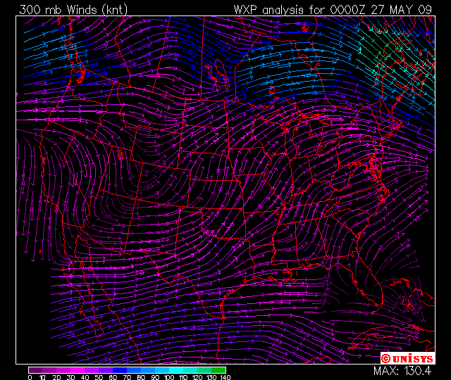
This is the 300mb wind vector map. Note the spot offshore tampa.
Note the vectors that are in completely different directions. This shows that air is rising in this area, has nowhere to go once it hits this level, and basically goes everywhere.
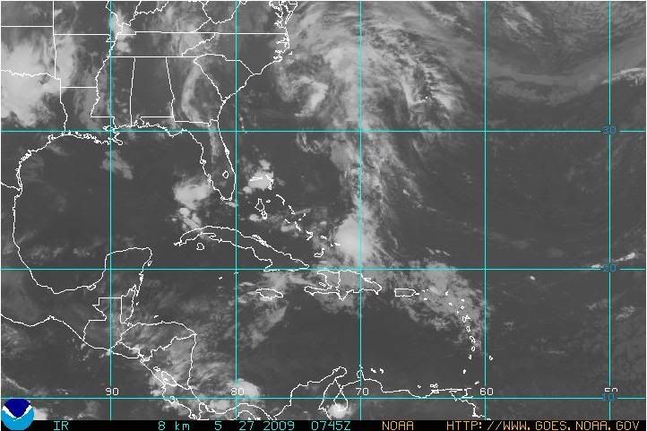
See the effect? Look at the IR sat view in the same spot. Also note that this upper level divergence covers most all of south FL and it also seems to be supporting a similar disturbed patch across FL into the gulf stream and almost to the Bahamas.
I think this is a shortwave trough, am I right?
This is the 300mb wind vector map. Note the spot offshore tampa.
Note the vectors that are in completely different directions. This shows that air is rising in this area, has nowhere to go once it hits this level, and basically goes everywhere.
See the effect? Look at the IR sat view in the same spot. Also note that this upper level divergence covers most all of south FL and it also seems to be supporting a similar disturbed patch across FL into the gulf stream and almost to the Bahamas.
I think this is a shortwave trough, am I right?
0 likes
Return to “USA & Caribbean Weather”
Who is online
Users browsing this forum: cheezyWXguy, cycloneye, wxman22 and 43 guests