

New storms trying to pop.
Moderator: S2k Moderators


KWT wrote:Yeah I did notice that on the longer loops wxman57 but the Dvorak numbers are still rising and I think in this case if we do get a reading of 2.5 then I can imagine we may get an upgrade, esp with reagrds to how sharp they were at upgrading this in the first place.


CrazyC83 wrote:I don't see upgrading until 11 pm at the earliest.

cycloneye wrote:CI still creeping up now to 2.3
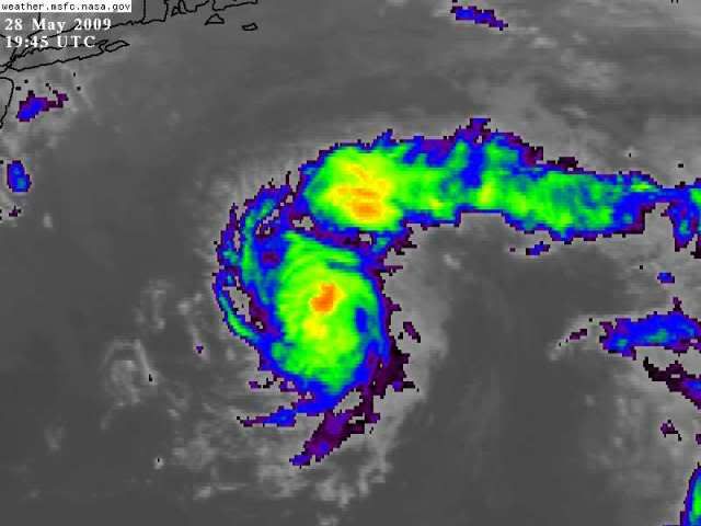
UW - CIMSS
ADVANCED DVORAK TECHNIQUE
ADT-Version 7.2.3
Tropical Cyclone Intensity Algorithm
----- Current Analysis -----
Date : 28 MAY 2009 Time : 194500 UTC
Lat : 37:49:16 N Lon : 69:50:00 W
CI# /Pressure/ Vmax
2.3 /1006.6mb/ 33.0kt
Final T# Adj T# Raw T#
(3hr avg)
2.3 2.7 2.7
Latitude bias adjustment to MSLP : +0.0mb
Center Temp : -21.7C Cloud Region Temp : -34.6C
Scene Type : CURVED BAND with 0.46 ARC in MD GRAY
Positioning Method : FORECAST INTERPOLATION
Ocean Basin : ATLANTIC
Dvorak CI > MSLP Conversion Used : ATLANTIC
Tno/CI Rules : Constraint Limits : NO LIMIT
Weakening Flag : OFF
Rapid Dissipation Flag : OFF
jinftl wrote:If it's going to become Ana, it really will have to do it by morning at the latest....time is running out....but this system has shown itself to be a bit tenacious and underestimated so i wouldn't rule it out quite yet....it is over the Gulf Stream still and shear is low.
WmE wrote:jinftl wrote:If it's going to become Ana, it really will have to do it by morning at the latest....time is running out....but this system has shown itself to be a bit tenacious and underestimated so i wouldn't rule it out quite yet....it is over the Gulf Stream still and shear is low.
Yeah. Also if it were to be named it'd be the third consecutive season with a named storm before June 1.
Users browsing this forum: No registered users and 44 guests


