ENSO Updates (2007 thru 2023)

This is the general tropical discussion area. Anyone can take their shot at predicting a storms path.

Moderator: S2k Moderators

Forum rules

The posts in this forum are NOT official forecasts and should not be used as such. They are just the opinion of the poster and may or may not be backed by sound meteorological data. They are NOT endorsed by any professional institution or STORM2K. For official information, please refer to products from the National Hurricane Center and National Weather Service.

Help Support Storm2K
Message
Author
jinftl
Category 5
Category 5
Posts: 4312
Joined: Tue Aug 31, 2004 4:47 pm
Location: fort lauderdale, fl

Re: ENSO Updates

#721 Postby jinftl » Sun May 24, 2009 9:05 am

Not sure of the difference, but NOAA uses the "Pdf corrected" version of the model runs in their weekly analysis...from last week that version is (interesting little dip in forecast during the fall back towards enso neutral for forecast consensus (blue line):

Image

CPC considers El Niño or La Niña conditionsto occur when the monthly Niño3.4 SST departures meet or exceed +/-0.5°C along with consistent atmospheric features. These anomalies must also be forecasted to persist for 3 consecutive months. As of last week, the SST anomaly of Niño 3.4 was 0.3ºC...enso neutral, so the earliest period that could be considered an el nino phase would be June-July-August (a la 2004 season....actual SST anomalies from that year are very close to the forecast consensus line for this year..interesting)

Once the threshold is met....it must persist over time....otherwise it could be the result of the normal ups and downs that take place in sst's given the detailed look we give them.


wxman57 wrote:NCEP ensembles get warmer with each run. Now approaching +2 above normal late this year. Already approaching El Nino threshold of +0.5 deg.
0 likes   

User avatar
wxman57
Moderator-Pro Met
Moderator-Pro Met
Posts: 22978
Age: 67
Joined: Sat Jun 21, 2003 8:06 pm
Location: Houston, TX (southwest)

Re: ENSO Updates

#722 Postby wxman57 » Sun May 24, 2009 10:47 am

From my observations this spring, the SSTs in Nino 3.4 are rising faster than the NCEP models were forecasting during the winter, and even faster than they were forecasting last month. So the NCEP models appear to be verifying much better than the other models.
0 likes   

Ed Mahmoud

Re: ENSO Updates

#723 Postby Ed Mahmoud » Sun May 24, 2009 12:08 pm

wxman57 wrote:From my observations this spring, the SSTs in Nino 3.4 are rising faster than the NCEP models were forecasting during the winter, and even faster than they were forecasting last month. So the NCEP models appear to be verifying much better than the other models.


In laymen's terms, are we getting to 1997 or even 1983 "Season Cancel" proportions?
0 likes   

User avatar
Category 5
Category 5
Category 5
Posts: 10074
Age: 35
Joined: Sun Feb 11, 2007 10:00 pm
Location: New Brunswick, NJ
Contact:

Re: ENSO Updates

#724 Postby Category 5 » Sun May 24, 2009 12:19 pm

Ed Mahmoud wrote:
wxman57 wrote:From my observations this spring, the SSTs in Nino 3.4 are rising faster than the NCEP models were forecasting during the winter, and even faster than they were forecasting last month. So the NCEP models appear to be verifying much better than the other models.


In laymen's terms, are we getting to 1997 or even 1983 "Season Cancel" proportions?


Layman's terms would've been "We're getting to a 1997 or 1983 el nino" :wink:
0 likes   

Ed Mahmoud

Re: ENSO Updates

#725 Postby Ed Mahmoud » Sun May 24, 2009 2:26 pm

Category 5 wrote:
Ed Mahmoud wrote:
wxman57 wrote:From my observations this spring, the SSTs in Nino 3.4 are rising faster than the NCEP models were forecasting during the winter, and even faster than they were forecasting last month. So the NCEP models appear to be verifying much better than the other models.


In laymen's terms, are we getting to 1997 or even 1983 "Season Cancel" proportions?


Layman's terms would've been "We're getting to a 1997 or 1983 el nino" :wink:


I ask, humbly, that the technical gurus, like x-y-no, add ñ as the "enye" character as I can't remember the alt-numbers command, and I think we could be talking a lot about the warm ENSO...
0 likes   

User avatar
wxman57
Moderator-Pro Met
Moderator-Pro Met
Posts: 22978
Age: 67
Joined: Sat Jun 21, 2003 8:06 pm
Location: Houston, TX (southwest)

Re: ENSO Updates

#726 Postby wxman57 » Sun May 24, 2009 2:48 pm

Ed Mahmoud wrote:
In laymen's terms, are we getting to 1997 or even 1983 "Season Cancel" proportions?


If a moderate El Nino appears by August/September, then it may knock down the number of storms to a bit below average, perhaps 9-10. But we've had many such season with quite major impacts (Betsy, Alicia, Andrew). So don't get used to 15-16 named storms per season.
0 likes   

Ed Mahmoud

Re: ENSO Updates

#727 Postby Ed Mahmoud » Sun May 24, 2009 2:53 pm

Betsy was an El Neenyo year?


Does E.N. favor Miami to NOLA tracks, somehow?
0 likes   

User avatar
cycloneye
Admin
Admin
Posts: 145308
Age: 68
Joined: Thu Oct 10, 2002 10:54 am
Location: San Juan, Puerto Rico

Re: ENSO Updates

#728 Postby cycloneye » Sun May 24, 2009 3:19 pm

One big monster that I saw in person was Hugo (cat 3 here) in 1989 a el Nino year with only 11 named storms.To me it doesnt matter how many form but where the ones that form will go.

Image
0 likes   

jinftl
Category 5
Category 5
Posts: 4312
Joined: Tue Aug 31, 2004 4:47 pm
Location: fort lauderdale, fl

Re: ENSO Updates

#729 Postby jinftl » Sun May 24, 2009 4:57 pm

Here is a comparison of the 3-month ONI values for 1997....anything over 0.5 SST anomaly is considered el nino...

1997:
JFM = -0.3
FMA = 0.0
MAM = 0.4
AMJ = 0.8 (we were well into el nino conditions in may 1997, right now (may 2009) we are enso neutral)
MJJ = 1.3
JJA = 1.7
JAS = 2.0
ASO = 2.2
SON = 2.4

Compared to 2009 readings available (for full 3 month period):
JFM = -0.7
FMA = -0.5

as of last week, the reading was 0.3...so the march-april-may composite will probably be close to 0.0 or under....compared to 0.4 in 1997. Further, with May almost done and a reading of 0.3, the April-May-June value would have an almost impossible time skyrocketing to the 0.8 el nino reading from same period 1997 (figure the 3 month composite, is roughly the midpoint value of the 3 months, or where we were last week).

The statistical difference between the values of 2.0+ from 1997 and the 0.5 to 1.5 values forecast for the latter part of 2009 is huge.....not even the outlier models are hinting at those levels.

I see ONI values very reminiscent of 2004 if anything....in terms of timeframe and intensity


2004:
JFM = 0.3
FMA = 0.2
MAM = 0.2
AMJ = 0.3
MJJ = 0.5 (el nino conditions began to appear in June/July 2004)
JJA = 0.7
JAS = 0.8
ASO = 0.9
SON = 0.8


Ed Mahmoud wrote:
wxman57 wrote:From my observations this spring, the SSTs in Nino 3.4 are rising faster than the NCEP models were forecasting during the winter, and even faster than they were forecasting last month. So the NCEP models appear to be verifying much better than the other models.


In laymen's terms, are we getting to 1997 or even 1983 "Season Cancel" proportions?
0 likes   

User avatar
cycloneye
Admin
Admin
Posts: 145308
Age: 68
Joined: Thu Oct 10, 2002 10:54 am
Location: San Juan, Puerto Rico

Re: ENSO Updates

#730 Postby cycloneye » Wed May 27, 2009 1:32 pm

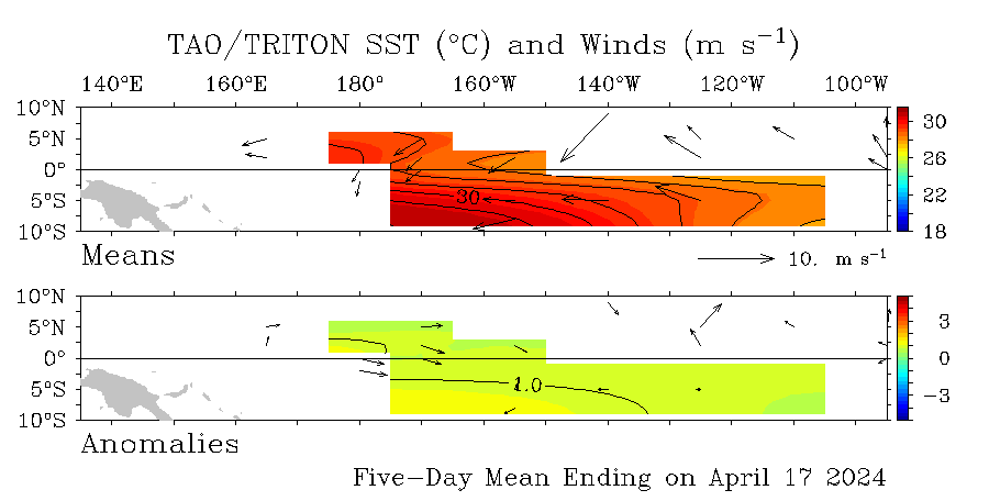
Latest graphic of the Pacific anomalies show a slow warming but still not considered to be at El Nino thresholds.

This graphic updates every day.

Image

http://www.pmel.noaa.gov/tao/
0 likes   

User avatar
cycloneye
Admin
Admin
Posts: 145308
Age: 68
Joined: Thu Oct 10, 2002 10:54 am
Location: San Juan, Puerto Rico

Re: ENSO Updates

#731 Postby cycloneye » Wed May 27, 2009 6:29 pm

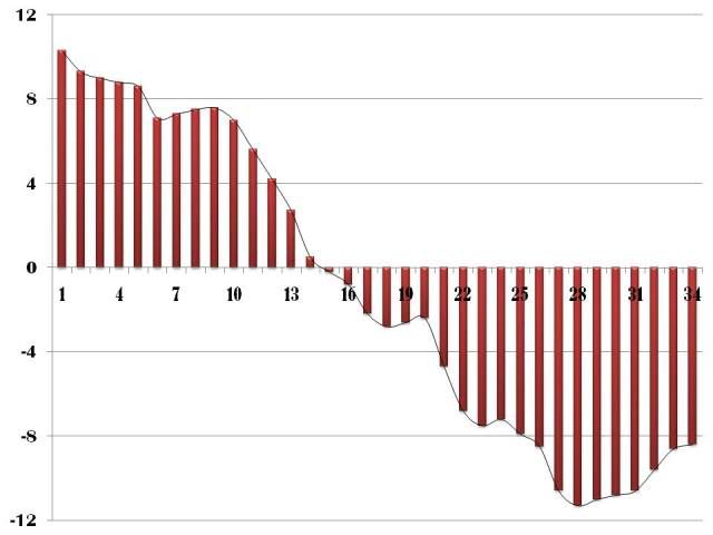
Here is one month of data (April 26-May 26) of the SOI and it shows a wild swing up and down.The tanking of the SOI has stopped some.

2009032820090426 10.3
2009032920090427 9.3
2009033020090428 9
2009033120090429 8.8
2009040120090430 8.6
2009040220090501 7.1
2009040320090502 7.3
2009040420090503 7.5
2009040520090504 7.6
2009040620090505 7
2009040720090506 5.6
2009040820090507 4.2
2009040920090508 2.7
2009041020090509 .5
2009041120090510 -.2
2009041220090511 -.8
2009041320090512 -2.2
2009041420090513 -2.8
2009041520090514 -2.6
2009041620090515 -2.4
2009041720090516 -4.7
2009041820090517 -6.8
2009041920090518 -7.5
2009042020090519 -7.2
2009042120090520 -7.9
2009042220090521 -8.5
2009042320090522 -10.6
2009042420090523 -11.3
2009042520090524 -11
2009042620090525 -10.8
2009042720090526 -10.6

Image

http://www.bom.gov.au/climate/enso/soi.dt3
0 likes   

User avatar
cycloneye
Admin
Admin
Posts: 145308
Age: 68
Joined: Thu Oct 10, 2002 10:54 am
Location: San Juan, Puerto Rico

Re: ENSO Updates

#732 Postby cycloneye » Fri May 29, 2009 3:57 pm

Dr Jeff Masters update of ENSO

Interesting analysis from Dr Jeff Masters about El Nino chances increasing during the peak of the 2009 season.The question is what kind of El Nino will evolve (Weak,Moderate or Strong) when it is officially declared.

Posted by: JeffMasters, 3:38 PM GMT on May 29, 2009

Sea surface temperatures in the Equatorial Eastern Pacific have been rising steadily for several months, and there is now a very real possibility that an El Niño event could occur during the peak of the Atlantic hurricane season, August - October. This is important, since the number and intensity of Atlantic tropical storms and hurricanes is usually reduced during an El Niño year, thanks to the increased wind shear such events bring to the tropical Atlantic. Last month, Columbia University's International Research Institute (IRI) was giving a 30% chance of an El Niño event for the coming hurricane season; this month, they have bumped their odds up to 45%. The Australian Bureau of Meteorology notes that "recent trends are consistent with the very early stages of a developing El Niño". NOAA's Climate Prediction Center forecasts the current neutral conditions in the Equatorial Eastern Pacific will continue into the summer, but shows that their CFS El Niño model is predicting a moderate El Niño event for the coming hurricane season.

Image

El Niño forecast models
The latest suite of runs by the various computer models used to forecast El Niño offer two main forecasts for the coming hurricane season: neutral conditions will persist, or an El Niño will develop (Figure 2). There are two types of models used to make these forecasts: statistical models and dynamical models. The statistical models have been around the longest, and they rely on statistics of how past El Niño episodes have developed in order to make a forecast. Dynamical models don't care about what has happened in the past. They make a forecast by taking the current state of the atmosphere, putting the data on a grid covering the entire globe, then solving the equations that govern the physics of the atmosphere and ocean on each point of this grid every few minutes, marching forward in time for many months. These dynamical models, in many cases, are simply modified versions of the same models we use to forecast the short-term weather. For example, the NOAA's Coupled Forecast System (CFS) model is based on the GFS model that we use to track hurricanes and make short-term weather forecasts. The main difference is that the CFS model runs for many months instead of just a few days.

Which model to believe?
As is the case with all seasonal forecasts, El Niño forecasts are not very good, and don't do much better than flipping a coin. However, thanks to intensive research efforts and the doubling of computer power that has been occurring every 1.5 years, the El Niño forecasts by the dynamical models have improved considerably over the past few years. These models now do about as well as the traditional statistical models, and should continue to improve as computer power continues to increase and our understanding of El Niño increases. Over the past two months, the dynamical models have increasingly been forecasting the development of an El Niño this Fall. To illustrate, in March only three of the thirteen dynamical models were predicting an El Niño event for hurricane season. By mid-May, this had increased to nine out of thirteen models. However, none of the eight statistical El Niño models are forecasting an El Niño event for the Fall, and their forecasts should be respected, as well. The IRI web site has a nice tool one can use to study the performance of the individual models. To my eye, the Japanese Meteorological Agency (JMA) dynamical model has made the best El Niño forecasts over the past two years (though I haven't done a rigorous error analysis to verify this). The JMA model is predicting a weak El Niño event for the coming hurricane season, and I am going to go along with that forecast.

Image

What will an El Niño event do to hurricane numbers?
Since the active hurricane period we are in began in 1995, there have been four El Niño events (Figure 3). During these years, the number of named storms, hurricanes, and intense hurricanes 11 named storms, 5 hurricanes, and 3 intense hurricanes. This is close to the average levels we've seen over the past 60 years--10-11 named storms, 6 hurricanes, and 2 intense hurricanes. If, on the other hand, we look at the five years that had neutral conditions, the numbers are considerably higher--18 named storms, 10 hurricanes, and 5 intense hurricanes. So, let's hope for an El Niño this year. Note, though, that one of our worst hurricane years--2004, which featured hurricanes Ivan, Charlie, Frances and Jeanne, which all hit Florida--was an El Niño year. It seems that in years like 2004, there is a lag between the time a El Niño event develops and the response of the atmosphere over the Atlantic. There is no way of forecasting at this point whether this could be the case this year. One argument against a repeat of 2004 is the presence of much lower heat content and SSTs in the tropical Atlantic this year compared to 2004.


Image
0 likes   

User avatar
wxman57
Moderator-Pro Met
Moderator-Pro Met
Posts: 22978
Age: 67
Joined: Sat Jun 21, 2003 8:06 pm
Location: Houston, TX (southwest)

Re: ENSO Updates

#733 Postby wxman57 » Fri May 29, 2009 10:13 pm

I still don't get the chart below. The forecasts start in April on that chart. Isn't there an updated version with the models run in May? Currently, the anomaly is +0.3 to +0.4. That's warmer than any model in the chart below was forecasting by the beginning of June.

Image

Meanwhile, NCEP ensembles are going warmer and warmer and warmer, reaching El Nino (0.5C) in a few weeks and a very healthy El Nino for August/September. Stronger than 2002, 2004, and 2006, but not as strong as 1997, probably.

Image
0 likes   

User avatar
KWT
Category 5
Category 5
Posts: 31415
Joined: Tue Aug 17, 2004 11:02 am
Location: UK!!!

#734 Postby KWT » Sat May 30, 2009 4:42 am

True, does look like being a moderate El Nino accoring to that, though I've noticed in many other events they do overdo the development of such events at times. Still I suppose even if it is slightly overdone its going to shut the season down early I'd have thought.
0 likes   

OURAGAN
Category 1
Category 1
Posts: 451
Joined: Sat Aug 07, 2004 12:18 pm
Location: GUADELOUPE

Re: ENSO Updates

#735 Postby OURAGAN » Sat May 30, 2009 9:12 am

1989, was an el nino year and we got Hurricane Hugo in Guadeloupe.
NOAA prédict a stong 2009 West enhanced Africa monsoon system.
0 likes   

User avatar
wxman57
Moderator-Pro Met
Moderator-Pro Met
Posts: 22978
Age: 67
Joined: Sat Jun 21, 2003 8:06 pm
Location: Houston, TX (southwest)

Re: ENSO Updates

#736 Postby wxman57 » Sat May 30, 2009 9:28 am

OURAGAN wrote:1989, was an el nino year and we got Hurricane Hugo in Guadeloupe.
NOAA prédict a stong 2009 West enhanced Africa monsoon system.


Yes, and in the strong El Nino of 1983 there were only 4 named storms, one of which was a major hurricane that hit Houston. El Nino can lead to development closer in to the U.S., resulting in some major hits with little warning.
0 likes   

User avatar
cycloneye
Admin
Admin
Posts: 145308
Age: 68
Joined: Thu Oct 10, 2002 10:54 am
Location: San Juan, Puerto Rico

Re: ENSO Updates

#737 Postby cycloneye » Sat May 30, 2009 9:35 am

wxman57 wrote:
OURAGAN wrote:1989, was an el nino year and we got Hurricane Hugo in Guadeloupe.
NOAA prédict a stong 2009 West enhanced Africa monsoon system.


Yes, and in the strong El Nino of 1983 there were only 4 named storms, one of which was a major hurricane that hit Houston. El Nino can lead to development closer in to the U.S., resulting in some major hits with little warning.


In other words,no complacency at all,even if El Nino is out there.
0 likes   

User avatar
srainhoutx
S2K Supporter
S2K Supporter
Posts: 6919
Age: 67
Joined: Sun Jan 14, 2007 11:34 am
Location: Haywood County, NC
Contact:

Re: ENSO Updates

#738 Postby srainhoutx » Sat May 30, 2009 9:39 am

cycloneye wrote:
wxman57 wrote:
OURAGAN wrote:1989, was an el nino year and we got Hurricane Hugo in Guadeloupe.
NOAA prédict a stong 2009 West enhanced Africa monsoon system.


Yes, and in the strong El Nino of 1983 there were only 4 named storms, one of which was a major hurricane that hit Houston. El Nino can lead to development closer in to the U.S., resulting in some major hits with little warning.


In other words,no complacency at all,even if El Nino is out there.


Always a good reminder that it only takes 1 to make for a very bad season.
0 likes   

User avatar
cycloneye
Admin
Admin
Posts: 145308
Age: 68
Joined: Thu Oct 10, 2002 10:54 am
Location: San Juan, Puerto Rico

Re: ENSO Updates

#739 Postby cycloneye » Sat May 30, 2009 6:11 pm

SOI rising

After tanking to -11.3,the SOI has gone up again thru the last 7 days,as of this post -8.4.Lets continue to watch how this factor plays out in the comming weeks.

2009032820090426 10.3
2009032920090427 9.3
2009033020090428 9
2009033120090429 8.8
2009040120090430 8.6
2009040220090501 7.1
2009040320090502 7.3
2009040420090503 7.5
2009040520090504 7.6
2009040620090505 7
2009040720090506 5.6
2009040820090507 4.2
2009040920090508 2.7
2009041020090509 .5
2009041120090510 -.2
2009041220090511 -.8
2009041320090512 -2.2
2009041420090513 -2.8
2009041520090514 -2.6
2009041620090515 -2.4
2009041720090516 -4.7
2009041820090517 -6.8
2009041920090518 -7.5
2009042020090519 -7.2
2009042120090520 -7.9
2009042220090521 -8.5
2009042320090522 -10.6
2009042420090523 -11.3
2009042520090524 -11
2009042620090525 -10.8
2009042720090526 -10.6
2009042820090527 -9.6
2009042920090528 -8.6
2009043020090529 -8.4

Image
0 likes   

User avatar
HURAKAN
Professional-Met
Professional-Met
Posts: 46086
Age: 38
Joined: Thu May 20, 2004 4:34 pm
Location: Key West, FL
Contact:

#740 Postby HURAKAN » Sat May 30, 2009 6:51 pm

Image
0 likes   


Return to “Talkin' Tropics”

Who is online

Users browsing this forum: cycloneye, duilaslol, Google [Bot], Stratton23, TampaWxLurker and 37 guests