Area of disturbed weather in the Caribbean
Moderator: S2k Moderators
Forum rules
The posts in this forum are NOT official forecasts and should not be used as such. They are just the opinion of the poster and may or may not be backed by sound meteorological data. They are NOT endorsed by any professional institution or STORM2K. For official information, please refer to products from the National Hurricane Center and National Weather Service.
- cycloneye
- Admin
- Posts: 145625
- Age: 68
- Joined: Thu Oct 10, 2002 10:54 am
- Location: San Juan, Puerto Rico
Re: Caribbean development next week?
This will be the area to watch if the models are right.


0 likes
- cycloneye
- Admin
- Posts: 145625
- Age: 68
- Joined: Thu Oct 10, 2002 10:54 am
- Location: San Juan, Puerto Rico
Re: Caribbean development next week?
Dr Jeff Masters Analysis of Possible Western Caribbean Development
Western Caribbean development possible next week
An area of disturbed weather has developed over Central America and the adjacent waters of the Eastern Pacific and Western Caribbean, associated with a tropical wave interacting with the Intertropical Convergence Zone (ITCZ) in the Eastern Pacific. This disturbance has generated 1 - 2 inches of rain over Costa Rica and western Panama over the past day, and is likely to bring 4 - 6 more inches of rain to those areas and Nicaragua over the next 3 - 4 days, as the storm drifts northwards into the Western Caribbean. The subtropical jet stream, which is currently bringing high wind shear to the Caribbean, is expected to shift northwards next week, bringing low wind shear to the region. The last few runs of several of our major dynamical computer weather forecast models have been pointing to the possible development of a tropical depression southwest of Jamaica by Thursday of next week. Heavy rains from the disturbance should spread into Jamaica and Cuba by Thursday and Friday, and may affect the Bahamas, Haiti, and South Florida 7 - 8 days from now.
0 likes
- AtlanticWind
- S2K Supporter
- Posts: 1891
- Age: 66
- Joined: Sun Aug 08, 2004 9:57 pm
- Location: Plantation,Fla
From Jeff Masters Weather underground
Western Caribbean development possible next week
An area of disturbed weather has developed over Central America and the adjacent waters of the Eastern Pacific and Western Caribbean, associated with a tropical wave interacting with the Intertropical Convergence Zone (ITCZ) in the Eastern Pacific. This disturbance has generated 1 - 2 inches of rain over Costa Rica and western Panama over the past day, and is likely to bring 4 - 6 more inches of rain to those areas and Nicaragua over the next 3 - 4 days, as the storm drifts northwards into the Western Caribbean. The subtropical jet stream, which is currently bringing high wind shear to the Caribbean, is expected to shift northwards next week, bringing low wind shear to the region. The last few runs of several of our major dynamical computer weather forecast models have been pointing to the possible development of a tropical depression southwest of Jamaica by Thursday of next week. Heavy rains from the disturbance should spread into Jamaica and Cuba by Thursday and Friday, and may affect the Bahamas, Haiti, and South Florida 7 - 8 days from now.
0 likes
-
- Admin
- Posts: 20012
- Age: 62
- Joined: Sun Aug 27, 2006 8:23 pm
- Location: Florence, KY (name is Mark)
Re: Caribbean development next week?
This is, what, the second time this year the GFS has indicated a system that appears to be in the Atlantic but is in fact in the EPAC and will probably be at least an invest. Every year. 

0 likes
Re: Caribbean development next week?
This is interesting. How strong of a storm could form this early with low wind shear?
cycloneye wrote:Dr Jeff Masters Analysis of Possible Western Caribbean DevelopmentWestern Caribbean development possible next week
An area of disturbed weather has developed over Central America and the adjacent waters of the Eastern Pacific and Western Caribbean, associated with a tropical wave interacting with the Intertropical Convergence Zone (ITCZ) in the Eastern Pacific. This disturbance has generated 1 - 2 inches of rain over Costa Rica and western Panama over the past day, and is likely to bring 4 - 6 more inches of rain to those areas and Nicaragua over the next 3 - 4 days, as the storm drifts northwards into the Western Caribbean. The subtropical jet stream, which is currently bringing high wind shear to the Caribbean, is expected to shift northwards next week, bringing low wind shear to the region. The last few runs of several of our major dynamical computer weather forecast models have been pointing to the possible development of a tropical depression southwest of Jamaica by Thursday of next week. Heavy rains from the disturbance should spread into Jamaica and Cuba by Thursday and Friday, and may affect the Bahamas, Haiti, and South Florida 7 - 8 days from now.
0 likes
Re: Caribbean development next week?


How could a storm form early with low wind shear- preexisting low level disturbance, a tropical wave interacting with the ITCZ/monsoon trough- as STJ lifts North, 0Z GFS showed an area of weak and weakly diffluent upper winds, which would favor maintenace of the thunderstorms, which would release latent heat as vapor condensed, with gentle exhaust, but no strong wind carrying the heat away, the system would develop a 'warm core', and if it can stay over warm water, it will become a natural version of a Carnot engine.
Or something isn't quite right, and nothing happens, or my personal and unofficial opinion, it develops in the EastPac.
GFS shows a sub-1000 mb storm hitting Cuba, which with GFS's coarse grid scale resolution, could easily mean a 990 mb Cat 1.
Now, Hurricane Audrey weakened to a Cat 1 before landfall in Louisiana, but it was stronger than a Cat 1 apparently in the Southern Gulf in late June, so my amateur opinion, a Cat 1 or higher is possible. There is an MIT doc who has tropical cyclone maximum intensities on a web site, but they seem worse case.
Unofficial, and amateur opinion above. Don't trust me at all for anything important.
0 likes
Re: Caribbean development next week?
Good analysis as always.
Ed Mahmoud wrote::uarrow:![]()
![]()
How could a storm form early with low wind shear- preexisting low level disturbance, a tropical wave interacting with the ITCZ/monsoon trough- as STJ lifts North, 0Z GFS showed an area of weak and weakly diffluent upper winds, which would favor maintenace of the thunderstorms, which would release latent heat as vapor condensed, with gentle exhaust, but no strong wind carrying the heat away, the system would develop a 'warm core', and if it can stay over warm water, it will become a natural version of a Carnot engine.
Or something isn't quite right, and nothing happens, or my personal and unofficial opinion, it develops in the EastPac.
GFS shows a sub-1000 mb storm hitting Cuba, which with GFS's coarse grid scale resolution, could easily mean a 990 mb Cat 1.
Now, Hurricane Audrey weakened to a Cat 1 before landfall in Louisiana, but it was stronger than a Cat 1 apparently in the Southern Gulf in late June, so my amateur opinion, a Cat 1 or higher is possible. There is an MIT doc who has tropical cyclone maximum intensities on a web site, but they seem worse case.
Unofficial, and amateur opinion above. Don't trust me at all for anything important.
0 likes
- cycloneye
- Admin
- Posts: 145625
- Age: 68
- Joined: Thu Oct 10, 2002 10:54 am
- Location: San Juan, Puerto Rico
Re: Caribbean development next week?
The jet stream will be way north of the Caribbean according to the 12 GFS data.


0 likes
- cycloneye
- Admin
- Posts: 145625
- Age: 68
- Joined: Thu Oct 10, 2002 10:54 am
- Location: San Juan, Puerto Rico
Re: Caribbean development next week?
12z GFS
90 hours=In Nicaragua.
http://www.nco.ncep.noaa.gov/pmb/nwprod ... n_090l.gif
126 hours=Still stuck in Nicaragua,weaker so far than the past runs.
http://www.nco.ncep.noaa.gov/pmb/nwprod ... n_126l.gif
144 hours=This run is a mess in terms of what it wants to do,I am done for this run.
http://www.nco.ncep.noaa.gov/pmb/nwprod ... n_144l.gif
90 hours=In Nicaragua.
http://www.nco.ncep.noaa.gov/pmb/nwprod ... n_090l.gif
126 hours=Still stuck in Nicaragua,weaker so far than the past runs.
http://www.nco.ncep.noaa.gov/pmb/nwprod ... n_126l.gif
144 hours=This run is a mess in terms of what it wants to do,I am done for this run.

http://www.nco.ncep.noaa.gov/pmb/nwprod ... n_144l.gif
0 likes
Re: Caribbean development next week?


If the 12Z Canadian doesn't do anything at all, well, as Derek Ortt has mentioned, it develops everything, so if that dog doesn't bark, well, the Canadian will hit the streets soon enough.
0 likes
- cycloneye
- Admin
- Posts: 145625
- Age: 68
- Joined: Thu Oct 10, 2002 10:54 am
- Location: San Juan, Puerto Rico
Re: Caribbean development next week?
12z CMC
It only has a weak low near Jamaica at 138 hours.

http://moe.met.fsu.edu/cgi-bin/cmctc2.c ... =Animation
It only has a weak low near Jamaica at 138 hours.

http://moe.met.fsu.edu/cgi-bin/cmctc2.c ... =Animation
0 likes
Re: Caribbean development next week?
The Phantom low is now gone how surprising on the 12z run.
0 likes
- cycloneye
- Admin
- Posts: 145625
- Age: 68
- Joined: Thu Oct 10, 2002 10:54 am
- Location: San Juan, Puerto Rico
Re: Caribbean development next week?
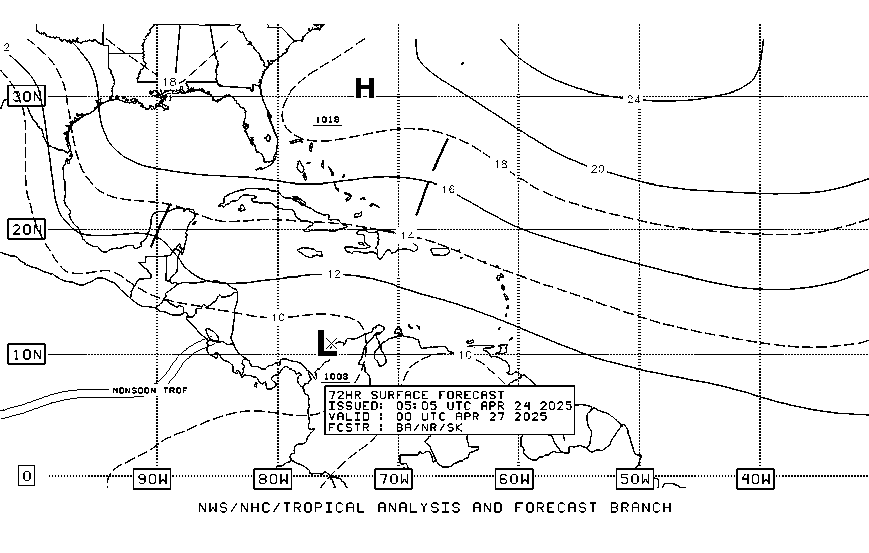
72 Hour Forecast from TAFB
I insist that the wave now east of the Lesser Antilles may be part of the trigger for something that may try to form in the Western Caribbean.

I insist that the wave now east of the Lesser Antilles may be part of the trigger for something that may try to form in the Western Caribbean.

0 likes
- cycloneye
- Admin
- Posts: 145625
- Age: 68
- Joined: Thu Oct 10, 2002 10:54 am
- Location: San Juan, Puerto Rico
Re: Caribbean development next week?
The cannadian model is on board with possible Caribbean development.Here is the 850mb vorticity graphic.

http://moe.met.fsu.edu/cgi-bin/cmctc2.c ... =Animation

http://moe.met.fsu.edu/cgi-bin/cmctc2.c ... =Animation
0 likes
Re: Caribbean development next week?
NWS Miami makes mention of it in latest Discussion...
IN THE EXTENDED PERIODS...THE SUITE OF GUIDANCE CONTINUES TO
SUGGEST A LOW DEVELOPING IN THE CARIBBEAN AND MOVING NORTHEAST TO
THE VICINITY OF THE CENTRAL BAHAMAS LATE NEXT WEEK...MUCH TOO LONG
IN THE EXTENDED FORECAST TO ADD ANY SPECULATION OTHER THAN AN
INTERESTING FEATURE TO MONITOR.
IN THE EXTENDED PERIODS...THE SUITE OF GUIDANCE CONTINUES TO
SUGGEST A LOW DEVELOPING IN THE CARIBBEAN AND MOVING NORTHEAST TO
THE VICINITY OF THE CENTRAL BAHAMAS LATE NEXT WEEK...MUCH TOO LONG
IN THE EXTENDED FORECAST TO ADD ANY SPECULATION OTHER THAN AN
INTERESTING FEATURE TO MONITOR.
0 likes
- cycloneye
- Admin
- Posts: 145625
- Age: 68
- Joined: Thu Oct 10, 2002 10:54 am
- Location: San Juan, Puerto Rico
Re: Caribbean development next week?
Here is the lateest HPC doscussion of Caribbean.
THE AMPLIFYING TROUGH OVER THE GULF/WESTERN CARIBBEAN IS TO
INTERACT WITH THE EASTERN PACIFIC ITCZ AND THE CLIMATOLOGICAL
TROUGH OVER SOUTHERN CENTRAL AMERICA. IN THIS PROCESS...IT WILL
INDUCE THE NORTHWARD AMPLIFICATION OF THE CONVERGENCE ZONE INTO
THE SOUTHERN CARIBBEAN THROUGH 30-36 HRS...WHILE FAVORING
FORMATION OF A CYCLONE OVER THE GULF OF PANAMA. THE LATEST RUN
(12Z) OF THE GFS FAVORS A SLOWER EVOLUTION/DISPLACEMENT OF THE
SURFACE CYCLONE THAN ON THE PREVIOUS MODEL RUNS...WITH LATEST
EVOLUTION CLOSER TO WHAT THE ECMWF SHOWS. THE LOW WILL SLOWLY LIFT
TO THE NORTH ACROSS THE ISTHMUS INTO THE GOLFO DE LOS MOSQUITOS/
BOCAS DEL TORO PANAMA BY 36-42 HRS...AND THEN SLOWLY LIFT NORTH
ALONG THE COAST OF NICARAGUA TO NORTHEAST OF CABO GRACIAS A
DIOS/PUERTO LEMPIRA BY 72-84 HRS. DURING THE NEXT 36-48 HRS IT
WILL SUSTAIN ORGANIZED CONVECTION OVER SOUTHERN NICARAGUA-COSTA
RICA/PANAMA TO NORTHERN COLOMBIA. BUT WE EXPECT THE BEST DYNAMICS
ALONG THE EASTERN SEMICIRCLE OF THE SURFACE CYCLONE TO CONCENTRATE
OVER PANAMA CANAL AREA-THE DARIEN TO GULF OF URABA/EJE CAFETERO IN
COLOMBIA/SANTANDERES-SIERRA DE SANTA MARTA...WITH RAINFALL AMOUNTS
OF 35-70MM/DAY AND MAXIMA OF 125-250MM. OVER COSTA RICA AND
SOUTHERN NICARAGUA EXPECT ACCUMULATION OF 15-20MM/DAY AND MAXIMA
OF 40-80MM. AFTER 36-48 HRS...WE EXPECT A DECREASE IN ACTIVITY
OVER BOTH PANAMA-COSTA RICA AS THE PACIFIC ITCZ PULLS NORTH OF THE
ISTHMUS...WITH ACCUMULATION TO DECREASE TO 10-15MM/DAY AND THE
MAXIMA TO PEAK AT 20-40MM. HEAVY CONVECTION WILL PERSIST OVER
NORTHERN COLOMBIA WHILE EXPANDING TO NORTHWEST AND CENTRAL
VENEZUELA WITH ACCUMULATION OF 15-25MM/DAY AND MAXIMA OF 35-70MM.
LOCALLY HIGHER AMOUNTS IN SANTANDERES COLOMBIA COULD REACH
150MM/DAY.
http://www.hpc.ncep.noaa.gov/discussions/fxca20.html
0 likes
- cycloneye
- Admin
- Posts: 145625
- Age: 68
- Joined: Thu Oct 10, 2002 10:54 am
- Location: San Juan, Puerto Rico
Re: Caribbean development next week?
12z ECMWF
Euro has a little more than the past runs.
http://www.ecmwf.int/products/forecasts ... 12!!!step/
Euro has a little more than the past runs.
http://www.ecmwf.int/products/forecasts ... 12!!!step/
0 likes
Who is online
Users browsing this forum: Hurricane2022, Killjoy12, LarryWx, ljmac75, NotSparta, ScottNAtlanta, weatherwindow and 61 guests